Items Similar to World Wind Currents Map – “Courants de l’Atmosphère” by Andriveau-Goujon, 1861


Want more images or videos?
Request additional images or videos from the seller
1 of 10
World Wind Currents Map – “Courants de l’Atmosphère” by Andriveau-Goujon, 1861
$469.31
£347.45
€390
CA$649.79
A$709.41
CHF 371.92
MX$8,616.07
NOK 4,644.61
SEK� 4,385.75
DKK 2,969.15
About the Item
World Wind Currents Map – “Courants de l’Atmosphère” by Andriveau-Goujon, 1861
This striking and educational antique chart titled “Courants de l’Atmosphère d’après le Lt. F. Maury” visualizes the major atmospheric wind systems of the Earth as understood in the mid-19th century. Published by E. Andriveau-Goujon in Paris in 1861, it forms part of the “Atlas Universel” and is based on the pioneering meteorological work of U.S. Navy Lieutenant Matthew Fontaine Maury, a key figure in the early scientific study of oceanography and global wind patterns.
The map illustrates prevailing wind directions and zones across the globe with great clarity, using a mix of colors, arrows, and hatching to differentiate between climatic belts and wind regimes. Trade winds (alizés), westerlies (vents de l’ouest), monsoons, calms (zones of relative atmospheric stillness), and polar winds are all distinctly marked. Notably, the red-striped zones indicate the northeast and southeast trade winds, while blue diagonal hatching identifies the westerlies.
A key feature is the inclusion of major monsoon systems over the Indian Ocean, Southeast Asia, and the western Pacific, labeled with directional arrows and seasonal annotations such as "Mousson du Sud-Ouest Avril–Octobre." The equatorial calms (calmes équatoriaux) and zones like the “Région des Ouragans” in the Caribbean are clearly demarcated, giving insight into both meteorological science and historical maritime navigation.
A circular inset in the lower left corner presents a vertical atmospheric profile titled “Diagramme des Vents et Profil de l’Atmosphère,” offering an illustrative cross-section of wind circulation by latitude and altitude. Deserts and arid zones are shaded in yellow and ochre according to the legend.
This chart is both scientifically fascinating and visually elegant—an outstanding example of 19th-century thematic cartography merging climatology, geography, and aesthetics. It reflects the growing 19th-century interest in global systems and navigation and would appeal to collectors of antique maps, maritime history, or early meteorological science.
Condition: Good. Slight toning and minor foxing to the margins. Original centerfold as issued. Clean plate impression and fresh hand coloring. Two tears around bottom folding line, repaired on reverse.
Framing tips: Best suited to a dark wood or brass-toned frame with a light ivory mat. A thin secondary mat in blue or grey can highlight the diagram’s fine scientific detailing while enhancing its decorative appeal.
Technique: Engraving with original hand coloring
Maker: E. Andriveau-Goujon, Paris, 1861
- Dimensions:Height: 20.91 in (53.1 cm)Width: 27.64 in (70.2 cm)Depth: 0.01 in (0.2 mm)
- Materials and Techniques:Paper,Engraved
- Place of Origin:
- Period:
- Date of Manufacture:1861
- Condition:Condition: Good. Slight toning and minor foxing to the margins. Original centerfold as issued. Clean plate impression and fresh hand coloring. Two tears around bottom folding line, repaired on reverse.
- Seller Location:Langweer, NL
- Reference Number:Seller: BG-14099-31stDibs: LU3054346185212
About the Seller
5.0
Recognized Seller
These prestigious sellers are industry leaders and represent the highest echelon for item quality and design.
Platinum Seller
Premium sellers with a 4.7+ rating and 24-hour response times
Established in 2009
1stDibs seller since 2017
2,641 sales on 1stDibs
Typical response time: <1 hour
- ShippingRetrieving quote...Shipping from: Langweer, Netherlands
- Return Policy
Authenticity Guarantee
In the unlikely event there’s an issue with an item’s authenticity, contact us within 1 year for a full refund. DetailsMoney-Back Guarantee
If your item is not as described, is damaged in transit, or does not arrive, contact us within 7 days for a full refund. Details24-Hour Cancellation
You have a 24-hour grace period in which to reconsider your purchase, with no questions asked.Vetted Professional Sellers
Our world-class sellers must adhere to strict standards for service and quality, maintaining the integrity of our listings.Price-Match Guarantee
If you find that a seller listed the same item for a lower price elsewhere, we’ll match it.Trusted Global Delivery
Our best-in-class carrier network provides specialized shipping options worldwide, including custom delivery.More From This Seller
View AllWind and Hurricane Map by A.K. Johnston – Meteorological Chart 1852
Located in Langweer, NL
Wind and Hurricane Map by A.K. Johnston – Meteorological Chart 1852
This scientifically significant 1852 map titled "The Distribution of the Constant, Periodical & Variable Winds Ov...
Category
Antique Mid-19th Century Scottish Prints
Materials
Paper

Antique Map Showing the Ocean Currents and Temperature of Air, '1872'
Located in Langweer, NL
Two maps on one sheet titled 'Johnson's Oceans Currents (..)' and 'Johnson's World showing the Distribution of the Temperature of the Air'. Original world map...
Category
Antique Late 19th Century Maps
Materials
Paper

$336 Sale Price
20% Off
Antique Map Showing the Distribution of the Currents of Air by Johnston '1850'
Located in Langweer, NL
Antique map titled 'Geographical Distribution of the Currents of Air'. Original antique map showing the distribution of the currents of air. This map originates from 'The Physical At...
Category
Antique Mid-19th Century Maps
Materials
Paper

$192 Sale Price
20% Off
Antique Map of the World Showing the Distribution of Plants and Minerals, 1872
Located in Langweer, NL
Antique map titled 'Johnson's World showing the distribution of the Characteristic Forest Trees (..)'. Original world map showing the distribution o...
Category
Antique Late 19th Century Maps
Materials
Paper

$192 Sale Price
20% Off
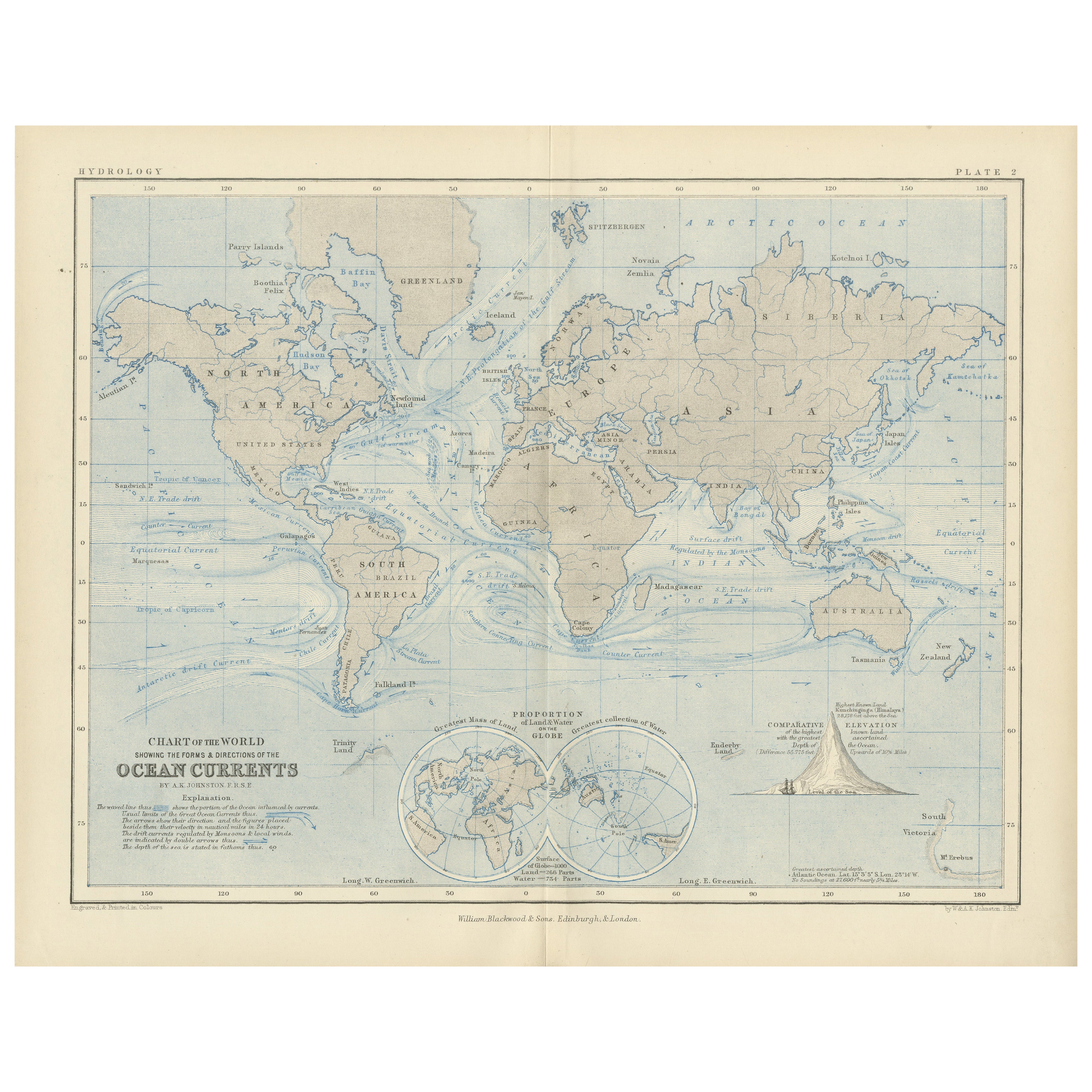
World Map of Ocean Currents by A.K. Johnston, Educational Print 1852
Located in Langweer, NL
World Map of Ocean Currents by A.K. Johnston, Educational Print 1852
This detailed and scientifically rich chart titled 'Chart of the World Showing the Form & Direction of the Ocean...
Category
Antique Mid-19th Century Scottish Prints
Materials
Paper
Antique Map showing Isotherm Lines throughout the World by Johnston '1850'
Located in Langweer, NL
Antique map titled 'Humboldt's System of Isothermal Lines'. Original antique map showing isotherm lines throughout the world. This map originates from 'The Physical Atlas of Natural ...
Category
Antique Mid-19th Century Maps
Materials
Paper

$192 Sale Price
20% Off
You May Also Like
Hemisphere Of The New Continent - Ancient Map by J.G. Heck - 1834.
By Johann Georg Heck
Located in Roma, IT
Hemisphere Of The New Continent is an artwork realized around 1760 by Johann Georg Heck
Original colored print.
Good conditions except for yellowing of paper and tears along the m...
Category
1830s Modern Figurative Prints
Materials
Etching

1864 Original illustrated planisphere - World Map - Geography
Located in PARIS, FR
Immerse yourself in the epic journey of the past with the Illustrated Historical Planisphere of 1864 by Charpentier! 🗺️ This cartographic treasure transports you through the intrica...
Category
1860s Prints and Multiples
Materials
Linen, Lithograph, Paper

Original Antique Map of The World by Dower, circa 1835
Located in St Annes, Lancashire
Nice map of the World
Drawn and engraved by J.Dower
Published by Orr & Smith. C.1835
Unframed.
Free shipping
Category
Antique 1830s English Maps
Materials
Paper

1850 Old French Map Depicting the Entire Earth's Surface Divided into Two Parts
Located in Milan, IT
Geographical map depicting the entire earth's surface divided into two parts that correspond to the two hemispheres where the emerged lands are depicted which have been classified wi...
Category
Antique Mid-19th Century French Maps
Materials
Glass, Wood, Paper

1850 Old French Map Depicting the Entire Earth's Surface Divided into Two Parts
Located in Milan, IT
Geographical map depicting the entire earth's surface divided into two parts that correspond to the two hemispheres or globes, the map deals with the earth in general. Detailed expla...
Category
Antique Mid-19th Century French Maps
Materials
Glass, Wood, Paper

Original Antique Map of The Eastern Hemisphere by Dower, circa 1835
Located in St Annes, Lancashire
Nice map of the Eastern Hemisphere
Drawn and engraved by J.Dower
Published by Orr & Smith. C.1835
Unframed.
Free shipping
Category
Antique 1830s English Maps
Materials
Paper

More Ways To Browse
Fontaine Antique
Antique Aly
Pair Of Danish Chairs
Veneer Dining Tables
1970 Italian Armchair
Furniture Uk
House Of Denmark Table And Chairs
Louis Marble Top Side Table
Antique Russian Rugs
Baker Furniture By
For Kids
Sterling Silver Flatware Set Service For 12
Tufted Bar
Pair Of French Antique Armchairs
1970s Brass Glass Coffee Table
Antique Column Base
Charles Rennie Mackintosh For Cassina
Glass Salt