Items Similar to Long Island Chart from 1828


Want more images or videos?
Request additional images or videos from the seller
1 of 8
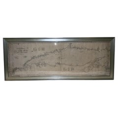
Long Island Chart from 1828
$6,500
£4,908.10
€5,694.41
CA$9,134.54
A$10,177.17
CHF 5,312.96
MX$123,564.40
NOK 66,780.49
SEK 63,123.79
DKK 42,508.07
About the Item
Rare original chart of Long Island Sound by E + G Blunt of New York, 179 Water St. "Surveyed in the years 1828, 29 & 30" Exceedingly rare and early chart, titled Long Island Sound from New York to Montauk Point by Edmund Blunt. This is a blue back chart that shows sea use and also backed in marine canvas. Tears and holes are present showing evidence of use.
Overall Dimensions: 32" H x 89" L . 35 pounds.
About the Seller
5.0
Vetted Professional Seller
Every seller passes strict standards for authenticity and reliability
Established in 1967
1stDibs seller since 2015
414 sales on 1stDibs
Typical response time: 1 hour
- ShippingRetrieving quote...Shipping from: Norwell, MA
- Return Policy
Authenticity Guarantee
In the unlikely event there’s an issue with an item’s authenticity, contact us within 1 year for a full refund. DetailsMoney-Back Guarantee
If your item is not as described, is damaged in transit, or does not arrive, contact us within 7 days for a full refund. Details24-Hour Cancellation
You have a 24-hour grace period in which to reconsider your purchase, with no questions asked.Vetted Professional Sellers
Our world-class sellers must adhere to strict standards for service and quality, maintaining the integrity of our listings.Price-Match Guarantee
If you find that a seller listed the same item for a lower price elsewhere, we’ll match it.Trusted Global Delivery
Our best-in-class carrier network provides specialized shipping options worldwide, including custom delivery.More From This Seller
View AllAntique Maritime Chart of East Coast Virginia to Nova Scotia
Located in Norwell, MA
1920 nautical chart of the East Coast of the United States from Virginia to Maine, New Brunswick, and Nova Scotia. The chart shows Cape Cod, Long Island, the Connecticut coast, Jersey Shore, Maine, New Hampshire, etc. Very detailed, showing ports, lighthouses, shoals, depths, etc. The chart is by famous cartographer George W. Eldridge, compiled from surveys of the United States government, British Admiralty, George Eldridge, and others. First authorized by George Eldridge, published in 1916 by Wilfred O. White with a merchant's stamp of Charles Hutchinson...
Category
Vintage 1920s North American Maps
Materials
Paper

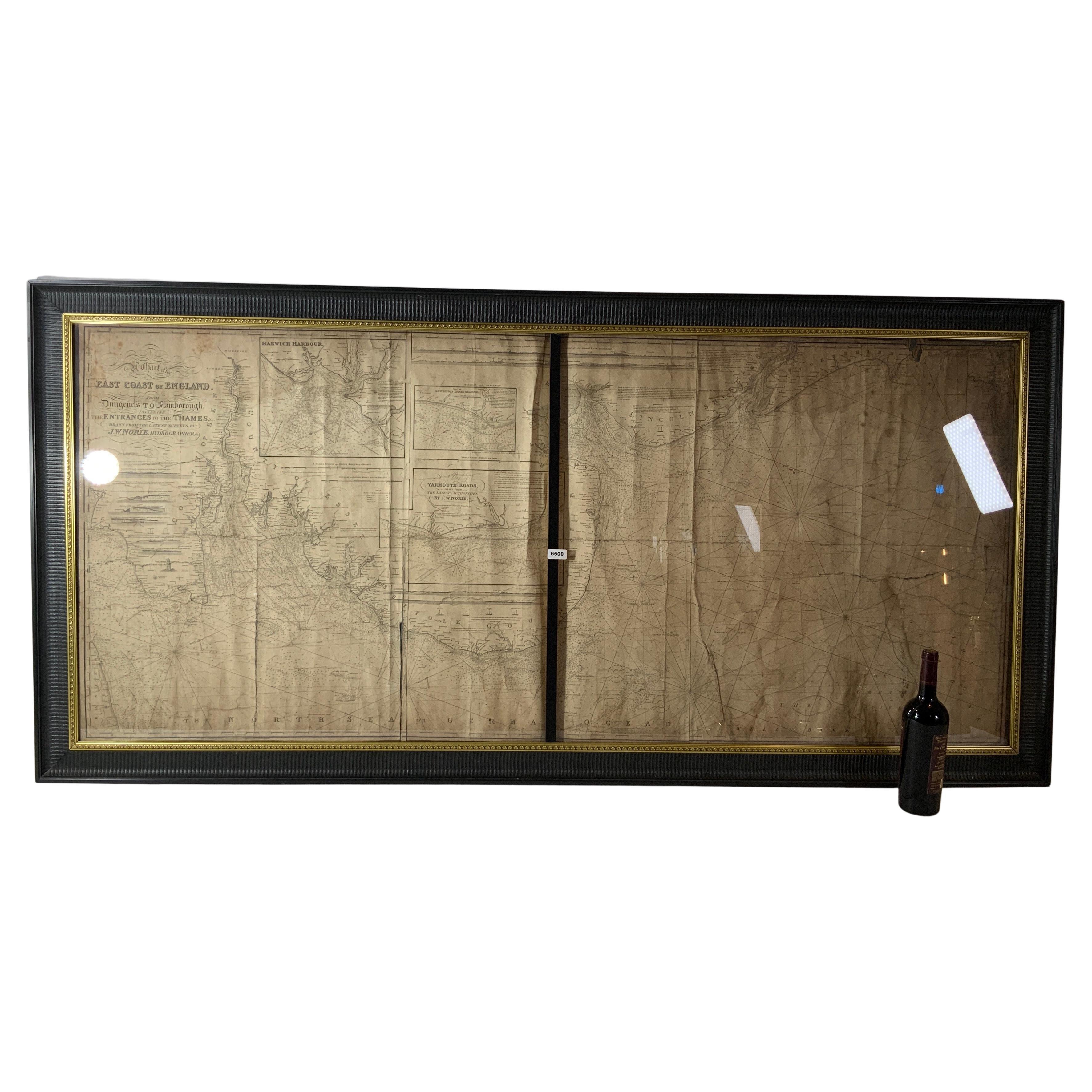
Chart of the East Coast of England
Located in Norwell, MA
Chart of the East Coast of England, from Dungeness to Flamborough, including the entrances to the Thames River. Drawn by hydrographer J.W. Norie in 1841. Includes Kent, Essex and Suf...
Category
Antique 1840s English Nautical Objects
Materials
Paper

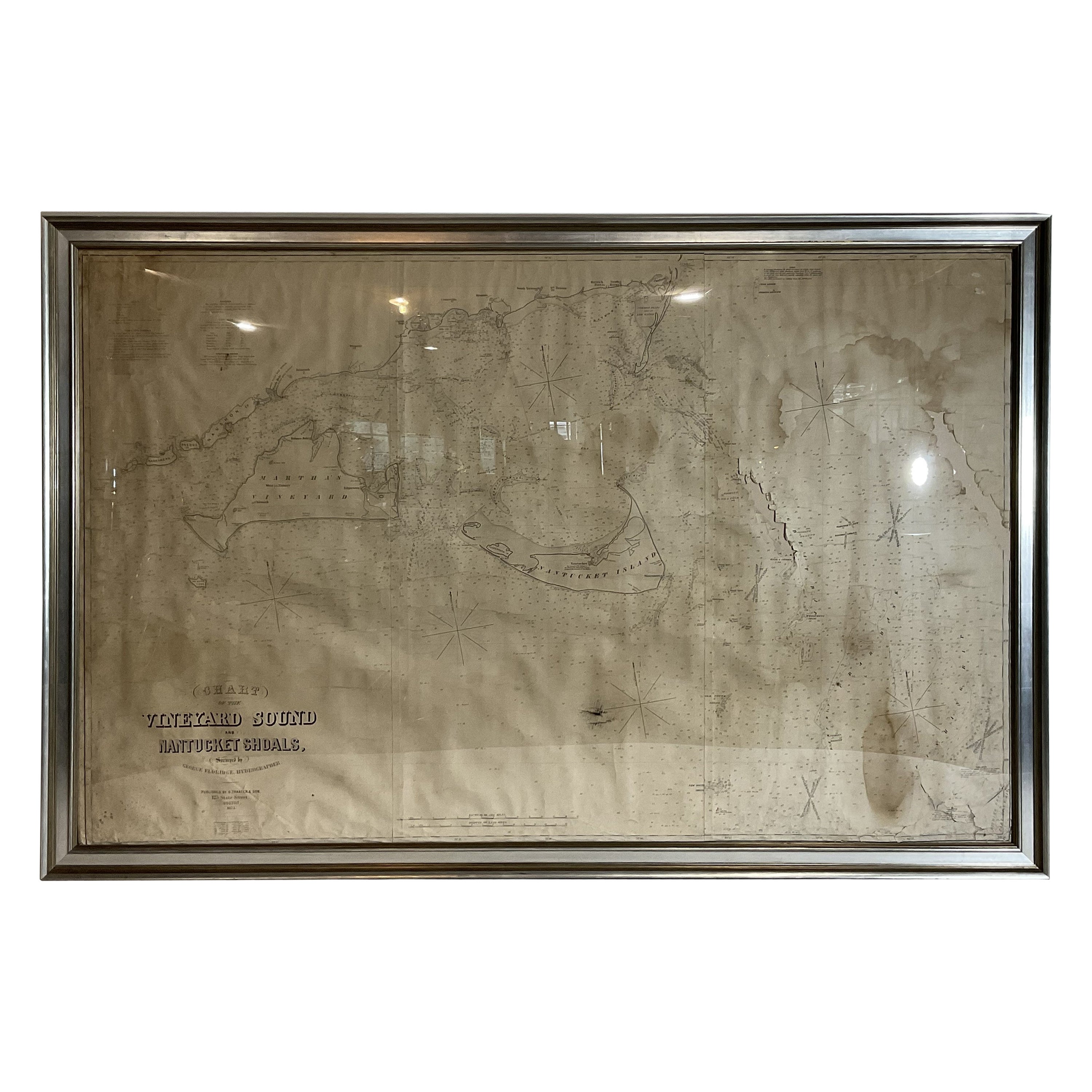
1873 Martha's Vineyard and Nantucket Chart
Located in Norwell, MA
Original chart of Nantucket and Martha's Vineyard by George Eldridge, Cartographer, 125 State Street, Boston. Dated 1873. Mounted to canvas. Also showing the coast of Cape Cod includ...
Category
Antique 1870s North American Maps
Materials
Paper

1898 Chart of Boston Bay
Located in Norwell, MA
Original 1898 chart showing Massachusetts Bay with the coast from Cape Ann to Cape Cod. This is a U.S. Navy Geodetic survey chart. All towns are noted along the coast. Framed with gl...
Category
Antique 1890s Nautical Objects
Materials
Paper

$1,495
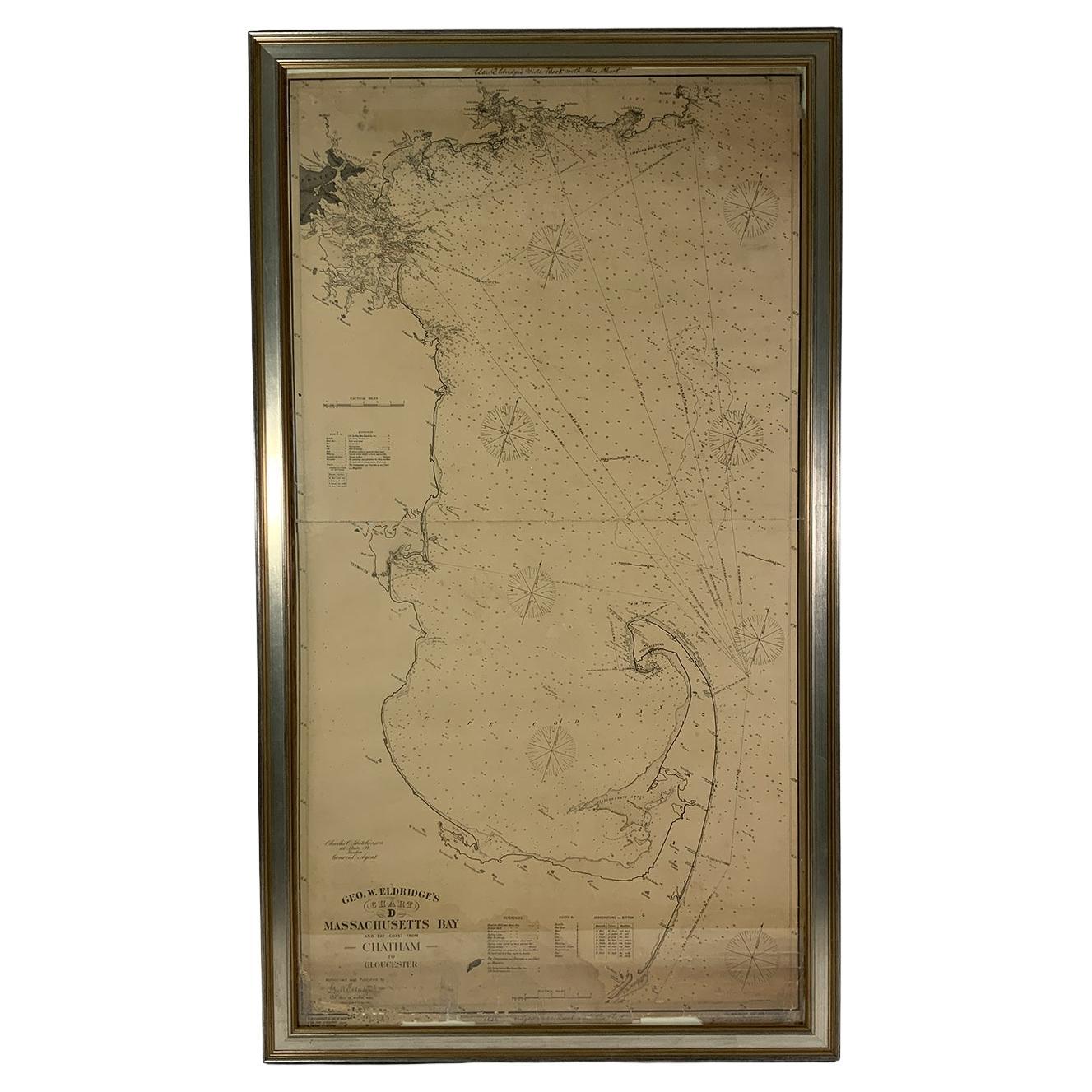
Ocean Chart Of Massachusetts Bay
Located in Norwell, MA
Cape Cod Bay chart from 1907 by George W. Eldridge. This is chart "D" Massachusetts Bay and the coast from Chatham to Boston. Showing plotted courses, depths, lighthouses, ports, etc.. Excellent graphics. Ports include Barnstable, Sandwich, Duxbury, Plymouth, Cohasset, Hingham, Quincy, Boston, Marblehead, Lynn. Manchester by the Sea...
Category
Antique Early 1900s North American Prints
Materials
Paper
1905 Chart of Long Island Sound by Eldridge
Located in Norwell, MA
Original chart of Long Island Sound by George Eldridge, date-stamped 1905. Also includes the seller's name, Ships Chandler Charles C. Hutchinson, 152 State St., Boston, General Agent...
Category
Antique Early 1900s North American Prints
Materials
Paper
You May Also Like
Large U.S. Coast and Geodetic Survey Chart A of the Atlantic Coast, 1877
Located in Nantucket, MA
Large U.S. Coast and Geodetic Survey Chart A of the Atlantic Coast, 1877, re-issued in February 1881, a printed paper laid down on linen navigational chart of the U.S. Atlantic coast...
Category
Antique 1880s American Other Maps
Materials
Linen

Old Map of Cook's Discovery and Charting of the East Coast of Australia, 1803
Located in Langweer, NL
Antique map titled 'Kaart van Nieuw Zuid Wales of de Oostlyke Kust van Nieuw Holland ontdekt en onderzogt door den Luitenant J. Cook met het Schip de Endeavour in het Jaar 1770'.
...
Category
Antique Early 1800s Maps
Materials
Paper

$1,662 Sale Price
20% Off
Rare 18th C. Newport Map
Located in Sandwich, MA
Rare 18th C, Map titled "A plan of the town of Newport in the province of Rhode Island". Earliest printed plan of Newport, published for the use of the British just prior to their o...
Category
Antique 1770s American Maps
Materials
Paper

$19,500 / item
19th Century Chart of New England Coast, 1847
By U.S. Government
Located in Nantucket, MA
19th Century Chart of New England Coast: the U.S. Coast Survey Sketch A - Section 1, a triangulation chart showing the progress of the survey and details along the New England coas...
Category
Antique 1840s American Other Maps
Materials
Paper

Antique Map of Cordes Bay and Surroundings
Located in Langweer, NL
Antique map titled 'Baye et Havre de Cordes (..)'. Four maps on the one sheet of; Cordes Bay, Port Famine, Woods Pay, Port Gallant, Fortescue Bay, Chile based on the voyage of John B...
Category
Antique Late 18th Century Maps
Materials
Paper
$247 Sale Price
20% Off
Chart of the Harbour of Liverpool
Located in Cheshire, GB
PL Burdett A Chart of the Harbour of Liverpool hand coloured. Encased in an ebonised frame.
Dimensions
Height 23.5 Inches
Width 28 Inches
Depth 1 Inches
Category
Early 20th Century British Maps
Materials
Paper

$633 Sale Price
20% Off