Want more images or videos?
Request additional images or videos from the seller
1 of 21
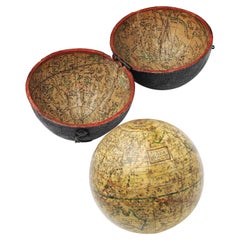
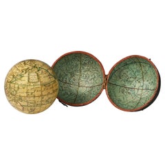
19th Century English Pocket Globe By Newton, London 1817
$13,186.26List Price
About the Item
- Creator:John & William Newton (Maker)
- Dimensions:Height: 3.82 in (9.7 cm)Diameter: 3.82 in (9.7 cm)
- Style:George III (Of the Period)
- Materials and Techniques:
- Place of Origin:
- Period:1810-1819
- Date of Manufacture:1817
- Condition:Minor losses. Minor fading. Slight gaps in the original paint of the sphere; some signs of use and some abrasions both on the globe and inside the case.
- Seller Location:Milano, IT
- Reference Number:1stDibs: LU4352219195552
About the Seller
4.3
Vetted Professional Seller
Every seller passes strict standards for authenticity and reliability
Established in 1860
1stDibs seller since 2018
21 sales on 1stDibs
Associations
International Confederation of Art and Antique Dealers' Associations
Authenticity Guarantee
In the unlikely event there’s an issue with an item’s authenticity, contact us within 1 year for a full refund. DetailsMoney-Back Guarantee
If your item is not as described, is damaged in transit, or does not arrive, contact us within 7 days for a full refund. Details24-Hour Cancellation
You have a 24-hour grace period in which to reconsider your purchase, with no questions asked.Vetted Professional Sellers
Our world-class sellers must adhere to strict standards for service and quality, maintaining the integrity of our listings.Price-Match Guarantee
If you find that a seller listed the same item for a lower price elsewhere, we’ll match it.Trusted Global Delivery
Our best-in-class carrier network provides specialized shipping options worldwide, including custom delivery.You May Also Like
19th Century English Globe by Renowned Cartographers John Newton and Son
By Newton and Son
Located in Southall, GB
An extremely rare and important 21 inch English globe by renowned cartographers John Newton and Son, one of the most important globe makers of early 19th century England. Representin...
Category
Antique 19th Century English Scientific Instruments
Materials
Hardwood
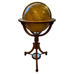
$53,824 Sale Price
20% Off
H 42 in W 27 in D 27 in
Rare George III Celestial Pocket Globe by Cary, London
By Cary
Located in Oxfordshire, United Kingdom
A fine and rare 3" celestial pocket globe by G & W Cary, Strand, London circa 1791, housed in its original sharkskin case.
A companion globe to terrestrial globes of this type we...
Category
Antique Late 18th Century English George III Aviation Objects
Materials
Plaster
19th Century German Miniature Pocket Terrestrial Globe
By C. Abel-Klinger
Located in Essex, MA
A miniature 19th century 3.5 inch diameter pocket terrestrial globe by C. Abel-Klinger, Nuremberg, Germany, in English for the English speaking markets. Signed with cartouche reading...
Category
Antique 1880s German Scientific Instruments
Materials
Brass
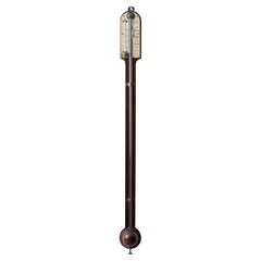
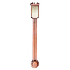
English Stick Barometer by Loftus, London, 19th Century
Located in Savannah, GA
A late 19th century rosewood stick barometer by Loftus of London.
3 ¼ inches wide by 36 inches tall; 3 inches deep
Category
Antique 19th Century English Scientific Instruments
Materials
Rosewood
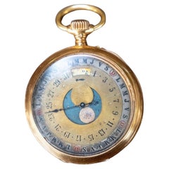
Pocket Watch, 19th century
Located in SAINT-OUEN-SUR-SEINE, FR
Magnificent 19th century pocket watch.
The glass is detached and bumps at the sides.
On the back on the watch, there is a perpetual calendar
Category
Antique 1890s French Napoleon III Collectible Jewelry
Materials
Gold
19th Century Antique English Georg III Mahogany Barometer
By Arval Argenti Valenza
Located in VALENZA, IT
A fine quality example of a mercury wheel barometer. A mahogany case. A wider and deeper case with an opening door for the long scale thermometer with silvered dial.
A silvered engraved dial signed 'J.B.Sala, Holborn'. Circa 1820.
The banjo barometer is also known as the wheel barometer. It was invented by Robert Hooke...
Category
Antique 1810s English George III Scientific Instruments
Materials
Mahogany
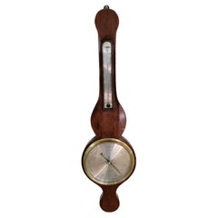
$1,716 Sale Price
20% Off
H 35.83 in W 10.24 in D 2.17 in
English Mahogany 19th Century Stick Barometer by Tarone
Located in Vero Beach, FL
English Mahogany 19th Century Stick Barometer by Tarone
Classic traditional English mahogany stick Barometer. Excellent and original feat...
Category
Antique 19th Century English Georgian Scientific Instruments
Materials
Silver
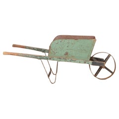
English 19th Century Wheelbarrow
Located in Haywards Heath, GB
Rustic English 19th Century wheelbarrow.
Made of pine and metal in original paint.
Circa 1900.
Category
Antique 19th Century English Architectural Models
Materials
Pine
Pair of 19th Century English J & W Cary Celestial/Terrestrial Table Model Globes
By John & William Cary
Located in Milford, NH
A fine assembled pair of 12-inch English table model globes on stands manufactured by J & W. Cary, the left globe with cartouche labeled “The New Celestial Globe, on which are correc...
Category
Antique Early 19th Century English Globes
Materials
Brass
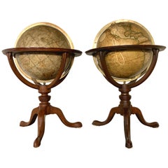
$18,900 / set
H 25 in Dm 16.5 in
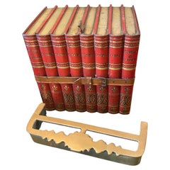
19th Century English tole box in the form of leather bound books
Located in Buchanan, MI
Rare set of four english tole boxes in the form of leather bound books.
Category
Antique 19th Century English George III Books
Materials
Metal
More From This Seller
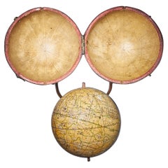
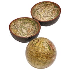
View AllEnglish Pocket Globe, London, Circa 1775-1798
By Herman Moll
Located in Milano, IT
Pocket globe
London, between 1775 and 1798
Re-edition of the globe of Hermann Moll (1678-1732) dated 1719
The globe is contained in its original case, which itself is covered in shark skin.
There are slight gaps in the original paint on the sphere. The case no longer closes.
The sphere measures 2.7 in (7 cm) in diameter whereas the case measures 2.9 in (7.4 cm) in diameter.
lb 0.22 (kg 0.1)
The globe is made up of twelve printed paper gores aligned and glued to the sphere.
In the North Pacific Ocean there is a cartouche with the inscription:
A Correct
Globe
with the new
Discoveries.
The celestial globe is depicted on the inside of the box and is divided into two hemispheres with the cartouche:
A correct globe
with ye new cons
relations of Dr.
Halley & c.
It shows the ecliptic divided into the days of the zodiacal calendar and the constellations represented as animals and mythological figures.
On the globe are delineated the equinoctial line, divided by degrees and hours, the ecliptic and the meridian (passing west of Greenwich). The continents are shaded and outlined in pink, green and yellow. It shows: the Cook routes; a wind rose in the Southern Indian Ocean; Antarctica without land; Africa with Negroland (Hermann Moll is considered the first geographer to name the West African region in his 1727 map. (Encyclopaedia Britannica, ed. 1902, under "States of Central Africa"); Tartary in Central Asia; the Mogul kingdom in northern India; in North America only New England, Virginia, Carolina, Florida, Mississippi are identified; California is already a peninsula; the northwest coast of America is "unknown parts" (Alaska is not described and it is only partially delineated, it was to become part of the United States in 1867); Mexico is named "Spain"; Central South America "Amazone America". Australia (which was to be so named after 1829) is called New Holland. The route of Admiral Anson is traced (1740) and the trade winds are indicated by arrows. (See Van der Krogt, P., Old Globes in the Netherlands, Utrecht 1984, p. 146 and Van der Krogt, P. - Dekker, E., Globes from the Western World, London 1993, pp. 115.)
Elly Dekker, comparing Moll’s 1719 globe and his re-edition (of which the one described above is a sample), identifies the differences between them: the two editions are quite similar to each other, but in the "anonymous" globe, compared to the previous globe of 1719, California looks like a proper peninsula - the reports of the Spanish explorers of the region had given rise to uncertainty over whether it was connected to the mainland or not. The geographical nature of California was confirmed after the explorations of Juan Bautista de Anza (1774-1776). The routes of Dampier's journey were partially erased and the route of Captain James Cook's first voyage was superimposed on them, and the geography of Australasia was adapted accordingly, including the denomination of the Cook Strait. See Dekker, Elly, Globes at Greenwich, 1999.
An important ante quem element is represented by Tasmania: it is not separated from Australia by the Bass Strait...
Category
Antique Late 18th Century English George III Globes
Materials
Shagreen, Paper
Pocket Globe by Nathaniel Hill, London 1754
Located in Milano, IT
Nathaniel Hill
Pocket globe
London, 1754
The globe is contained in its original case, which itself is covered in shark skin.
There are slight gaps in the original paint on the sphere. The case no longer closes.
The sphere measures 2.6 in (6.8 cm) in diameter whereas the case measures 2.9 in (7.4 cm) in diameter.
lb 0.24 (kg 0.11)
The globe is made up of twelve printed paper gores aligned and glued to the sphere.
In the North Pacific Ocean there is a scroll with the inscription:
A
New
terrestrial
Globe
by
Nath. Hill,
1754.
The celestial globe is depicted on the inside of the box.
On the terrestrial globe much of central and southern Africa is empty. North America bears only the name of some British colonies. It shows California as a peninsula and the northwest coast of America as "unknown parts" (Alaska is not described and is only partially delineated; it would become part of the United States in 1867). The route of Admiral Anson is traced (1740) and the trade winds are indicated by arrows. Australia, still named New Holland (the new name would be introduced in 1829), is part of the west coast. (See Van der Krogt, P., Old Globes in the Netherlands, Utrecht 1984, p. 146 and Van der Krogt, P. - Dekker, E., Globes from the Western World, London 1993, p. 115.)
Nathaniel Hill (London, news from 1746 to 1768) had impeccable professional credentials: he had done his apprenticeship with Richard Cushee, who at the time was carrying out surveying work for John Senex's Surrey map...
Category
Antique 1750s English George II Globes
Materials
Shagreen, Paper
Pocket Globe, Nicholas Lane, London, post 1779
By Nicholas Lane
Located in Milano, IT
Pocket Globe
Nicholas Lane
London, post 1779
The globe is contained in its original case, which is covered in leather.
The sphere measures 2.75 in (6.9 cm) whereas the case measure...
Category
Antique 1780s English Other Models and Miniatures
Materials
Leather, Wood, Paper
Miniature Terrestrial Globe Newton & Son London, Post 1833, Ante 1858
By Newton and Son
Located in Milano, IT
Miniature Terrestrial Globe
Newton & Son
London, post 1833, ante 1858
Paper, papier-mâché, bronze and wood
It measures: sphere diameter 2.95 in (7.6 cm); diameter of the wooden base 6.02 in (15.3 cm); height 8.36 in (21.24 cm).
Weight: 2,067 lb.
State of conservation: the globe still bears its original paint, but has various small gaps, abrasions and stains on the surface.
The globe is hinged with two pins at the meridian circle, which is in turn inserted perpendicular to the horizon circle; this is supported by four semi-arches connected at the bottom by a small goblet-shaped foot, resting on a wooden bell-shaped base.
Apart from the wooden base, the entire support structure is made of bronze; on the foot there are the scale reproductions of a compass, a telescope and an open book.
The sphere is made of papier-mâché and is covered with twelve printed paper gores.
In the North Pacific Ocean the globe bears a cartouche with the inscription (about 30% of the writing is illegible, but the missing parts can be easily integrated based on the rest):
NEWTON’S
New & Improved
TERRESTRIAL
Globe
Published by Newton & Son
66 Chancery Lane
LONDON
On the globe, much of central Africa is empty and the great lakes Tanganyika and Victoria are not marked (Europeans would begin to explore the area after 1858). Canada is called "British Territory" and Alaska "Russian Territory" (it would become part of the United States in 1867). Australia already bears its modern name (until 1829 it had been called New Holland) and its coasts are completely designed; Tasmania is listed as an island (Matthew Flinders circumnavigated it in 1798). The routes of Cook's various voyages are plotted; both the route followed by Biscoe in 1831 and the "Land of Enderby" which he discovered on the coast of Antarctica, south of Africa, are marked.
Bibliography
P. Van der Krogt, Old Globes...
Category
Antique 1840s English Early Victorian Maps
Materials
Bronze
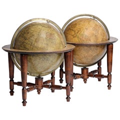
Pair of English 12-inch Globes by William Harris, London, 1832 and 1835
By William Harris
Located in Milano, IT
Pair of 12-inch table globes
William Harris
London, 1832 and 1835
Slight abrasions from use; few cracks
lb 11 each (kg 5)
The two terrestrial and celestial globes rest in their original Dutch style stands with four supporting turned wood columns.
Each one measures 12 in in height x 16.5 in in diameter with the diameter of the spheres measuring approximately 12 in; 48 cm in height x 42 cm in diameter x 31 cm diameter of the spheres.
The 12 inch measure was the most frequently used by British manufacturers of globes of this period.
Each globe is composed of two series of twelve printed paper gores, aligned and glued onto plaster spheres.
The brass circle of the meridian bears engravings...
Category
Antique 1830s English William IV Globes
Materials
Paper, Wood
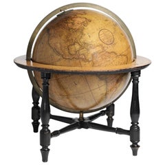
18-inch Globe, Cary's, London, 1840
By Cary’s
Located in Milano, IT
John and William Cary
Updated by George and John Cary
Terrestrial Globe
London, 1840
lb 22 (kg 10)
Slight surface abrasions due to use. A small crack on the horizon circle.
The globe rests in its original Dutch style stand with four supporting turned wood columns.
It measures 26 in in height x 23.6 in in diameter with the diameter of the sphere measuring 18 in; 66 cm in height x 60 cm in diameter with the diameter of the sphere measuring 45.72 cm.
The 18 inch...
Category
Antique 1840s English Early Victorian Globes
Materials
Paper, Wood
Recently Viewed
View AllMore Ways To Browse
Antique Armillary Sphere
Armillary Globe
Pocket Globe
Antique Pocket Globe
Brass Display Stand
Giltwood Barometer
Antique Brass Pans
Antique Binoculars
Antique Measuring Instruments
Antique Scientific Model
Antique Microscope
Louis Xvi Barometer
Opera Pearls
Weather Station
Antique Scales And Balances
Botanical Model
Brass Compass Antique
French Thermometer