Items Similar to Mechanical Equatorial Sundial, Johann Michael Bergauer, Ante 1745

Video Loading
Want more images or videos?
Request additional images or videos from the seller
1 of 19
Mechanical Equatorial Sundial, Johann Michael Bergauer, Ante 1745
$17,878.05
£13,238.59
€15,000
CA$24,585
A$27,344.84
CHF 14,311.70
MX$333,516.82
NOK 179,831.74
SEK 169,154.96
DKK 114,199.62
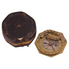
About the Item
Johann Michael Bergauer (Simonsfeld, 1676 - Innsbruck, 1745 circa)
Mechanical equatorial sundial
Signed: Michael Bergauer Insprugg? Innsbruck?
Ante 1745
Gilded and silvered brass; glass.
Measures: closed 1.29 x 3.50 x 4.92 in (33 x 89 x 125 mm); open 5.19 x 3.50 x 3.81 in (132 x 89 x 97 mm).
Weight: the sundial 0.49 lb (224 g); the case 0, 20 lb (95 g)
Original wooden case covered in brown leather.
State of conservation: very good. It has some signs of use. The spring that allowed for the two parts of the instrument to remain open is missing (absent even in the comparative specimens kept in museums).
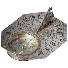
The sundial is composed of two overlapping plates hinged together on the north edge.
The base plate is octagonal and is supported by three turned legs. The upper face is gilded and a compass with a magnetic variation index has been inserted. The rest of the surface is occupied by a rich decoration of engraved scrolls, centered around the inscription “Michael Bergauer Insprugg”. A foldable oval support with a plumb-bob is attached with a hinge on the southern edge. On the reverse of the base plate a table of the latitudes of some European cities (expanded with the vertical writing “Meiland 40” on the edge and “Rome” deleted) and of Jerusalem has been engraved. A Cam marked for 0 °-70 ° is applied near the northern edge. This can be adjusted to change the inclination of the upper plate according to the latitude; originally a spring, now lost, made it possible to keep the two plates of the clock open.
The second plate is round, has a toothed edge and measures 3.26 in (83 mm) in diameter: it is slightly smaller than the octagonal base which it rests upon and overlaps when the instrument is closed.
The recto is gilded and there are three concentric graduated circles engraved on it:
- the outermost is the equatorial hour dial, numbered I-XII, I-XII;
- the second-one is that of days 1-30 of the lunar month and has “Aetas lunae” engraved on it;
- the third, silvered, is a subsidiary hour dial, with double numbering 1-12; originally it could have been rotated.
The engravings of the first two circles are enameled in red.
In the center - on the polar axis - there is an alidade, at the end of which is associated the silvered minute dial. This, in turn, is welded, perpendicularly, to a small disc, also silvered, with a triangular gnomon. The plate, alidade and minute dial are connected to each other by toothed mechanisms.
Below is the procedure for measuring the time:
1) Adjust the Cam under the base of the clock, based on the latitude of your location;
2) Place the watch on a flat surface using the plumb-bob and with the side closest to the compass facing south;
3) Keeping the instrument still, manually rotate the alidade until the shadow cast by the triangular gnomon on the small silvered disc falls on the line marked below it;
4) The hour and minutes can therefore be read on the hour and minute dials set on the alidade respectively.
Johann Michael Bergauer, who sometimes only signs his works as Michael Bergauer, was born in Simonsfeld, north of Vienna. His apprenticeship as a watchmaker took place in Landshut and he probably worked as a laborer in Augsburg before becoming a watchmaker at the court of Karl Philipp von der Pfalz in Innsbruck in 1708. In the following years, his repeated attempts to obtain Innsbruck citizenship are documented and, in 1721, he is listed as a resident. In 1724 he was admitted to the guild of watchmakers, with which however he had continuous problems. In 1732 he presented a "masterpiece". This is the last reference to his business; he must have died before or in 1745 because in that year his widow appealed to the City Council.
The mechanical sundial is compared with very similar examples preserved in:
- The British Museum, 1888, 1201.326;
- The British Museum, reg. no. OA.384;
- Greenwich Maritime Museum, reg. no. AST0469;
- History of Science Museum, Oxford, new inv. no. 51664;
- Germanisches Nationalmuseum, Nuremberg, WI1216;
- National Technical Museum, Praga.
Bibliography:
- Zinner E., Deutsche und Niederländische Astronomische Instrumente des 11.18. Jahrhunderts, Munich, 1979, passim;
- Francis Ward, A catalogue of scientific instruments in the Department of Medieval and later Antiquities of the British Museum, London 1981, s. v;
- Wolfgang, Eckhardt, Claude Dunod, Michael Bergauer und Johann Willebrand – Zur Geschichte der Minutensonnenuhr, Jahrbuch des Museums für Kunst und Gewerbe Hamburg 3, 1984, pp. 79-104;
- Gerard, L'E. Turner; Andrew, Turner, Scientific Instruments, 1500-1900: An Introduction, London 1998, p. 22;
- Higton H., Sundials at Greenwich, Oxford 2002, no. 165, pp. 181-2;
- Abeler J., Meister der Uhrmacherkunst, 2010, p. 59.
- Creator:Johann Michael Bergauer (Maker)
- Dimensions:Height: 1.3 in (3.3 cm)Width: 4.93 in (12.5 cm)Depth: 3.51 in (8.9 cm)
- Style:Baroque (Of the Period)
- Materials and Techniques:
- Place of Origin:
- Period:1730-1739
- Date of Manufacture:circa 1730
- Condition:Very good. It has some signs of use. The spring that allowed for the two parts of the instrument to remain open is missing (absent even in the comparative specimens kept in museums).
- Seller Location:Milano, IT
- Reference Number:1stDibs: LU4352228069592
About the Seller
4.3
Vetted Professional Seller
Every seller passes strict standards for authenticity and reliability
Established in 1860
1stDibs seller since 2018
21 sales on 1stDibs
Associations
International Confederation of Art and Antique Dealers' Associations
- ShippingRetrieving quote...Shipping from: Milano, Italy
- Return Policy
Authenticity Guarantee
In the unlikely event there’s an issue with an item’s authenticity, contact us within 1 year for a full refund. DetailsMoney-Back Guarantee
If your item is not as described, is damaged in transit, or does not arrive, contact us within 7 days for a full refund. Details24-Hour Cancellation
You have a 24-hour grace period in which to reconsider your purchase, with no questions asked.Vetted Professional Sellers
Our world-class sellers must adhere to strict standards for service and quality, maintaining the integrity of our listings.Price-Match Guarantee
If you find that a seller listed the same item for a lower price elsewhere, we’ll match it.Trusted Global Delivery
Our best-in-class carrier network provides specialized shipping options worldwide, including custom delivery.More From This Seller
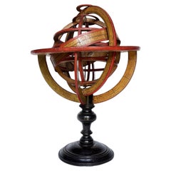
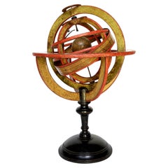
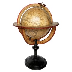
View AllPtolemaic Armillary Sphere, Charles-François Delamarche, Paris, ante 1798
By Charles Francois Delamarche
Located in Milano, IT
Ptolemaic armillary sphere
Charles-François Delamarche
Paris, ante 1798
Wood and papier-mâché
covered with printed and partly hand-colored paper
It measures 15.55 in in height x Ø 10...
Category
Antique 1790s French Other Scientific Instruments
Materials
Wood, Paper
Ptolemaic Armillary Sphere, Charles-François Delamarche, Paris, ante 1798
By Charles Francois Delamarche
Located in Milano, IT
Ptolemaic armillary sphere
Charles-François Delamarche
Paris, ante 1798
Wood and papier-mâché
covered with printed and partly hand-colored paper
It measures 16.37 in in height x Ø 10.94 in (41.60 cm - Ø 27.80 cm)
It weights 2.33 lb (1,058 g)
State of conservation: consistent with its age and use, the paper shows some signs of use, stains and abrasions.
The sphere is Ptolemaic, with the Earth placed at its center, surrounded by the Moon and the Sun mounted on two metal arms.
The sphere is composed of six horizontal and two vertical rings (armillae), each bearing graduations and its own name.
The first horizontal ring is illegible. The others, in descending order are: North Pole, Tropic of Cancer, Equator, Tropic of Capricorn, South Pole.
The vertical rings consist of two double meridians.
The sphere is then connected to the large meridian by two pins, a vertical ring inserted perpendicularly into the circle of the Horizon, in turn supported by four semicircles connected to the turned and black-stained wooden base.
Each element is covered with printed paper. It contains various pieces of information: latitudes, length of days, names and zodiac symbols, calendar, wind directions, etc.
The vertical circles mention the latitudes and longitudes of different cities: Rome, Bordeaux, Madrid, Boston, Batavia (Jakarta), Acapulco, etc.
Even the small terrestrial globe is covered with printed paper: continents and oceans appear with numerous geographical markings indicating the most recent explorations.
In the Pacific Ocean, west of South America bears the following inscription:
GLOBE
TERRESTRIAL
à Paris
chez Delamarche Géog
Rue du Foin Jacques
Au Collège de
M.e Gervais
The North American coasts are well delineated and California appears correctly as a peninsula - reports from Spanish explorers in the region had given rise to confusion as to whether it was connected to the mainland or not. The geographical nature of California was confirmed after the explorations of Juan Bautista de Anza (1774-1776).
Alaska is not described and is only partially traced; it would become part of the United States in 1867.
Various Pacific islands are indicated.
Australia (the name definitely used from 1824) is called "Nouvelle Hollande."
Tasmania is still represented as a peninsula and this is an important detail for the dating of our armillary sphere.
The island is separated from Australia by Bass Strait, which was crossed by Matthew Flinders for the first time in 1798, showing that it was not a peninsula. Delamarche certainly would not have waited a long time to update such an important geographical datum: presumably he did so shortly after receiving the news.
Charles-François Delamarche (1740-1817) founded his laboratory around 1770 and, in a few years, he became the most famous French cartographer and globe maker between the 18th and 19th centuries. After having acquired the laboratory of the late Didier Robert de Vaugondy (1723-1786; himself a renowned cartographer who continued the family business founded by his grandfather Nicolas Sanson in the seventeenth century) and after having purchased, between 1788 and around 1800, the businesses of Jean-Baptiste Fortin (1750-1831) and Jean Lattré (around 1750-1800), he began to call himself "Successeur de MM. Sanson and Robert de Vaugondi, Géographes du Roi and de M. Fortin, Ingénieur-mécanicien du Roi pour les globes et les sphères."
Thus, at the end of the eighteenth century, Delamarche possessed the warehouse stocks, as well as the manufacturing skills of the globes of his main rivals in Paris.
In addition to this aggressive acquisition policy, the key to its success also lay in the combination of high-quality cartography combined with extremely attractive globes and armillary spheres; and, of course, its famous red paint finishing touch.
His laboratory was located on Rue de Foin St Jacques "au Collège Me. (or "Mtre") Gervais" in the Latin Quarter of Paris until around 1805, when he moved to rue du Jardinet No. 13.
On the death of Charles-François in 1817, the reins of the company passed to his son Félix (1779-1835), who continued to publish, often in collaboration with the engraver Charles Dien, Sr. In 1835 the company first moved to rue du Jardinet No. 12 and a little later to rue du Battoir No. 7.
Bibliography:
Dekker, Elly, et al. Globes at Greenwich...
Category
Antique 1790s French Other Scientific Instruments
Materials
Wood, Paper
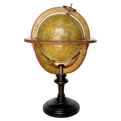
Ptolemaic Armillary Sphere Charles-François Delamarche Paris, 1805-1810 Circa
By Charles Francois Delamarche
Located in Milano, IT
Charles-François Delamarche
Ptolemaic armillary sphere
Paris, circa 1805-1810
Wood and papier-mâché
covered with printed and partly hand-coloured paper
It measures 15.74” in height, ...
Category
Antique Early 1800s French Empire Scientific Instruments
Materials
Paper, Wood

Celestial Table Globe, Charles-François Delamarche, Paris, 1791
By Charles Francois Delamarche
Located in Milano, IT
Celestial table globe
Charles-François Delamarche
Paris, 1791
It measures: 17.13 in in height, Ø max 27.7 in; the sphere Ø 7.09 in
(h 43.5 cm x Ø max 27.7 cm; the sphere Ø 18 cm).
W...
Category
Antique 1790s French Other Scientific Instruments
Materials
Metal
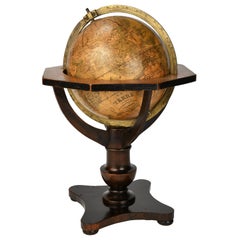
Terrestrial Table Globe by Félix Delamarche, Paris, 1821
By Félix Delamarche
Located in Milano, IT
Terrestrial table globe
Félix Delamarche
Paris, 1821
It measures 20.47 in height, Ø max 14.17 in; the sphere Ø 9.44 in (h 52 cm x Ø max 36.5 cm; the sphere Ø 24 cm)
Wood, printed...
Category
Antique 1820s French Restauration Scientific Instruments
Materials
Metal
German Globe by C. Abel-Klinger, Nuremberg, circa 1860
By C. Abel-Klinger
Located in Milano, IT
Terrestrial globe
Artistic company C. Abel - Klinger
Nuremberg, circa 1860
H cm 31 x 22 cm (12.20 x 8.66 in); sphere 14 cm (5.51 in) in diameter
lb 2.30 (kg 1.04)
State of conservation: good. On the sphere there are slight visible signs of accidental bumping at the poles, as well as on New Guinea and England (vertical and more visible); some ink stains, especially at the South Pole and on the meridian that crosses North America.
The globe is composed of twelve whole gores of printed paper, juxtaposed and glued on a sphere made with a chalky base mixture.
The circle of the meridian, made of brass...
Category
Antique 1860s German Other Scientific Instruments
Materials
Wood, Paper
You May Also Like
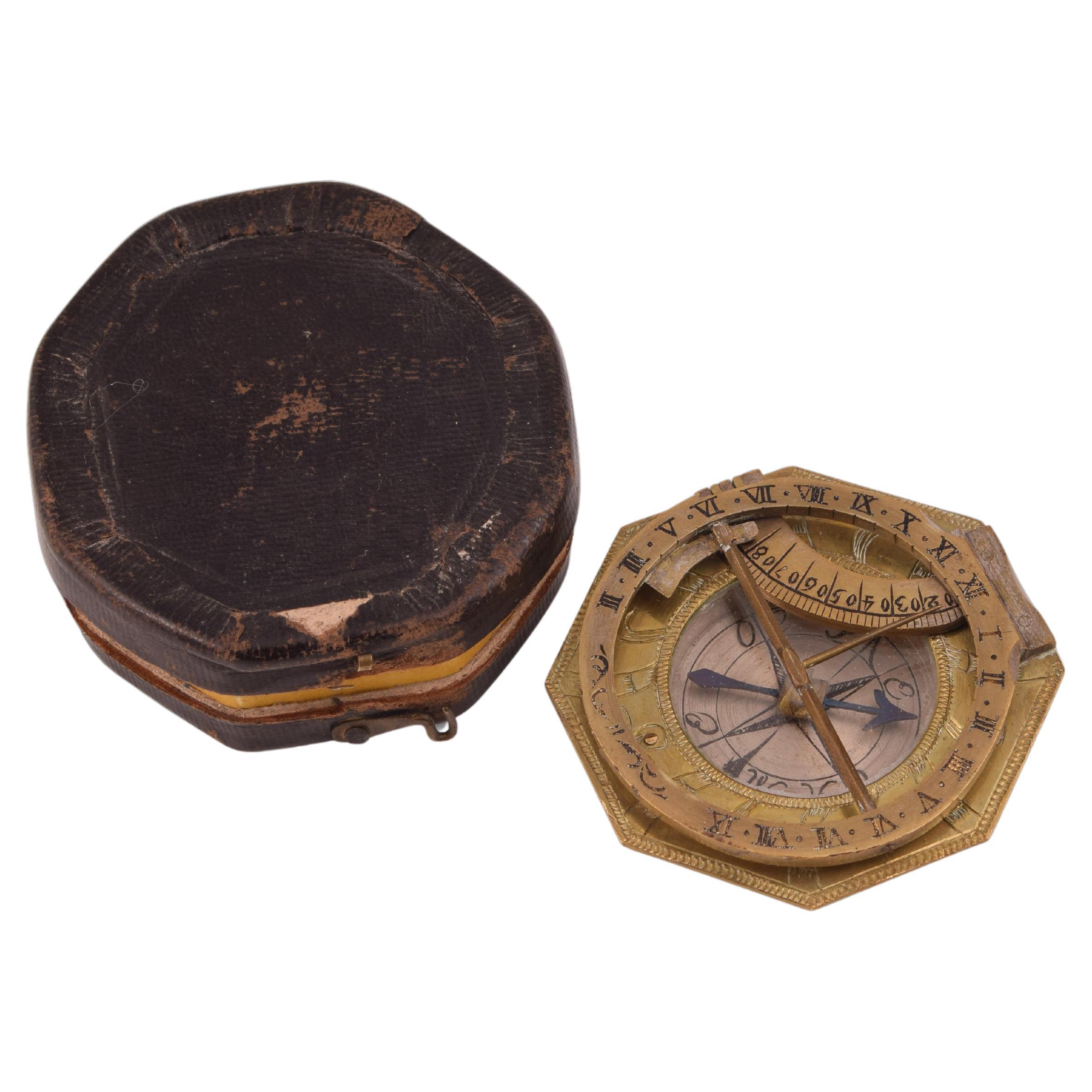
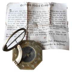
Sundial and Compass with Case, Schrettegger, Johan, Augsburg, Germany, Ca 1800
Located in Madrid, ES
Sundial and compass with case. Bronze. SCHRETTEGGER, Johan. Augsburg, Germany, around 1800.
Sundial with a polygonal shape made of bronze, engraved with plant elements on the front,...
Category
Antique Late 18th Century German Neoclassical Scientific Instruments
Materials
Bronze, Other
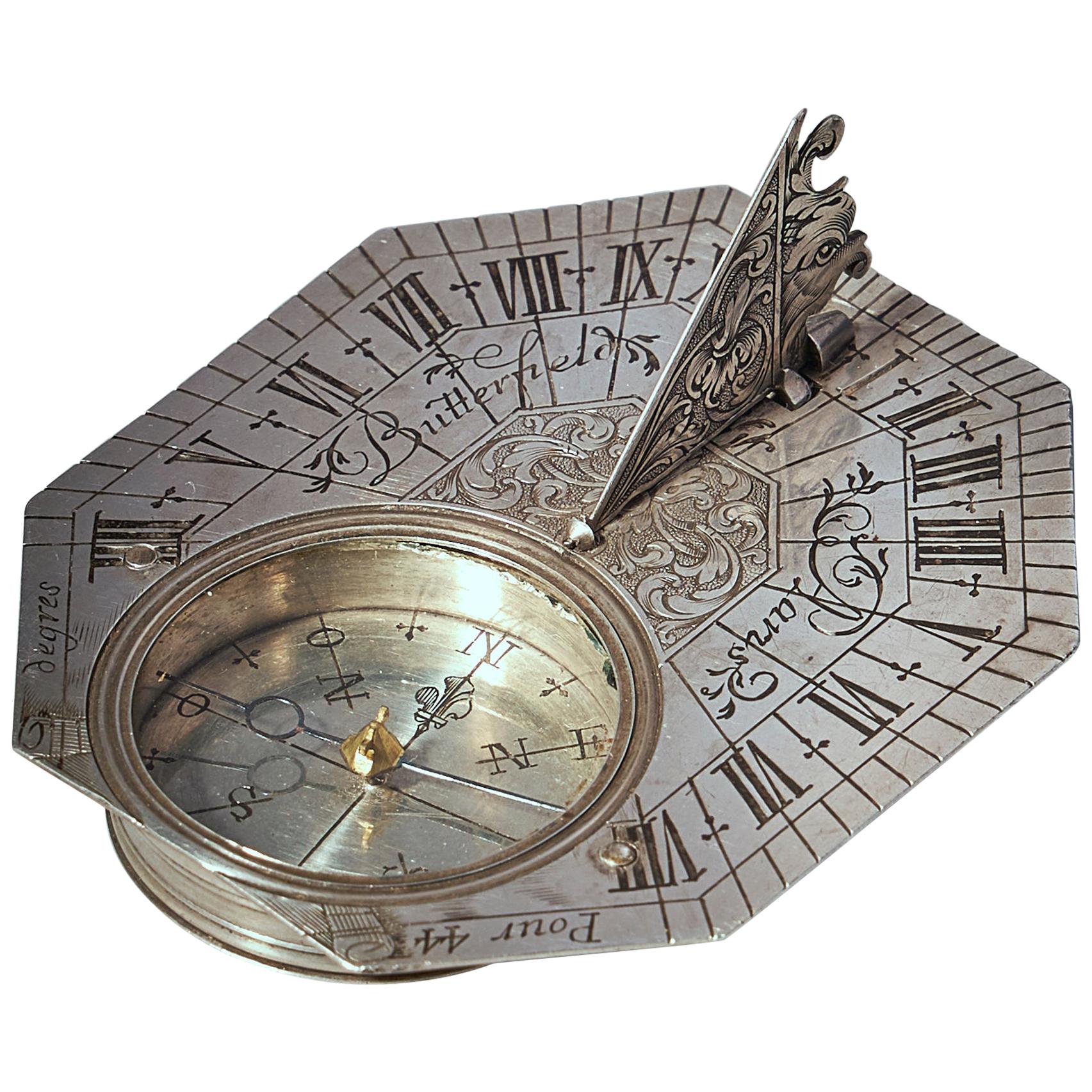
Rare Silver Pocket Sundial and Compass by Michael Butterfield, Paris, circa 1700
By Butterfield Paris
Located in Oxfordshire, United Kingdom
A beautiful, rare solid silver Anglo-French octagonal pocket sundial with compass by Michael Butterfield, circa 1700.
The sundial is made for a latitude of 44° and could be used in places in the south of France such as Avignon and elsewhere along this parallel. The elaborately engraved base plate has a Roman chapter ring on which the gnomon (a triangular flap) casts its shadow. It is signed by the maker in the following manner: Butterfield A Paris. On one side is a glazed recessed compass with a blued steel hand to position the instrument in such a way that the time can be read. The hinged triangular gnomon is richly engraved and in the shape of a bird’s head. The folding gnomon and cut corners enable the dial to be carried in the pocket.
The underside shows the latitudes of various Southern-French places in the relevant areas
Its maker Michael Butterfield was an English instrument maker who based himself in 'Le Quay de l'Horloge' of Paris from circa 1685. These types of dials, often replicated by other makers, became known as Butterfield Dials...
Category
Antique Late 17th Century French Louis XIV Carriage Clocks and Travel Cl...
Materials
Silver
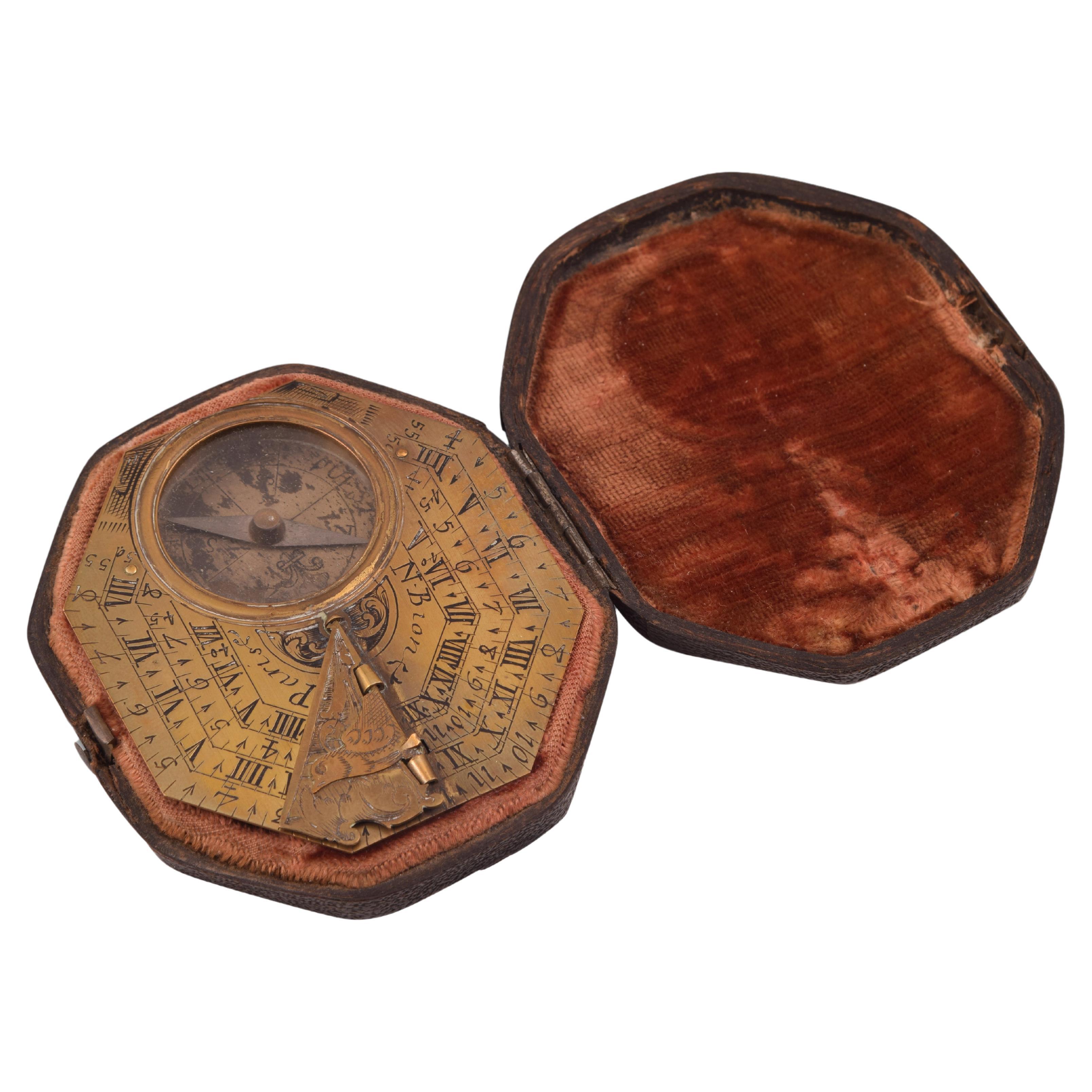
Sundial with Compass and Case, Bronze, Bion, Nicholas, Paris, 18th Century
By Nicholas Bion
Located in Madrid, ES
Sundial with compass and case. Bronze. BION, Nicholas. Paris, 18th century.
Polygonal sundial with a bird-shaped gnomon and engraved triangular piece, which presents, on one side, ...
Category
Antique 18th Century French Neoclassical Scientific Instruments
Materials
Bronze, Other
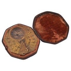
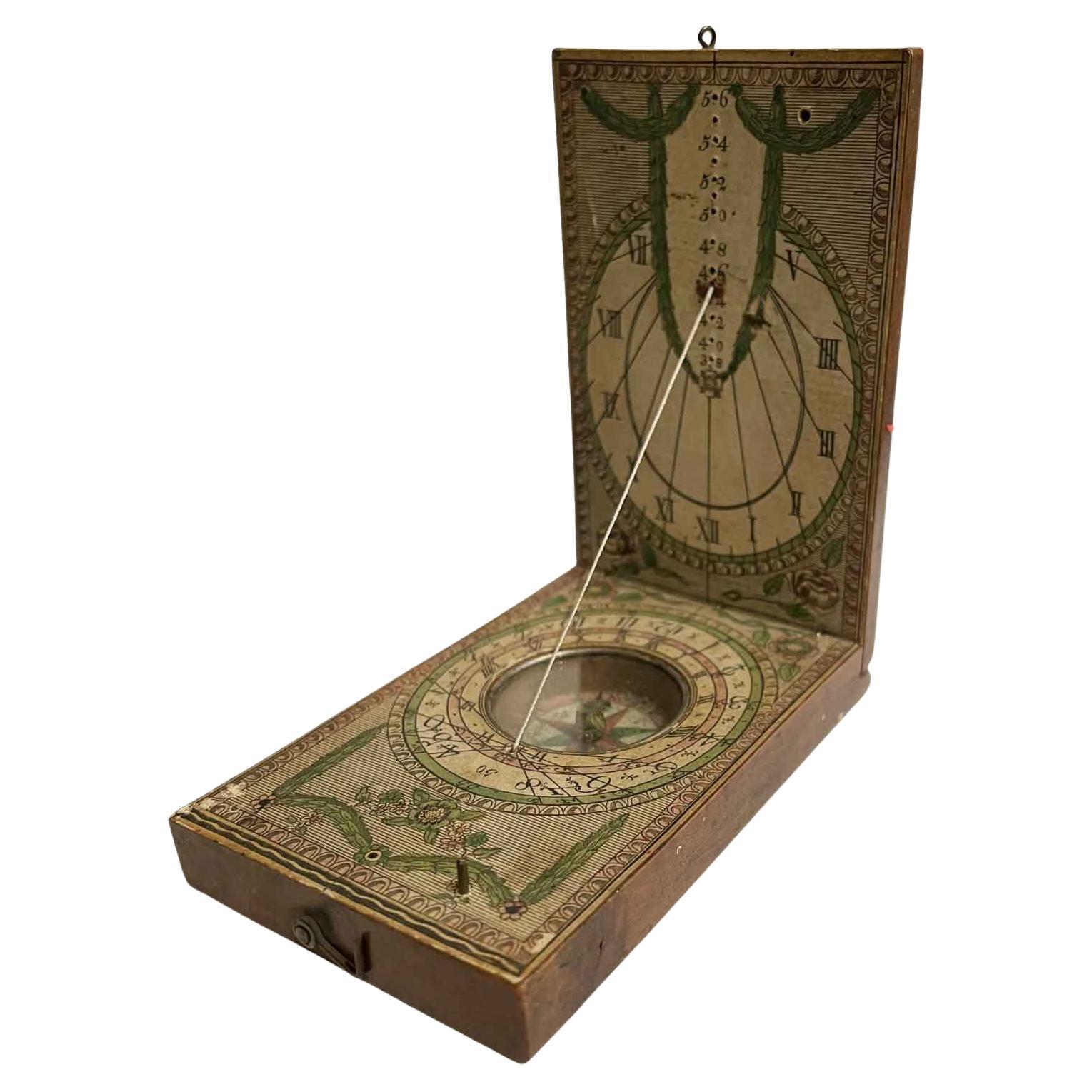
: Wooden pocket diptych sundial Ernst Christoph Stocket. Germany 1780 - 1811.
Located in Milan, IT
Wooden pocket diptych sundial Ernst Christoph Stocket - type, Bavaria. A folding wooden sundial is partially covered in paper with engraved/printed decorations and text. A compass is...
Category
Antique Late 18th Century German Scientific Instruments
Materials
Wood, Paper
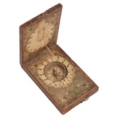
18th Century Diptych Portable Sundial And Compass by German Beringer
By David Beringer
Located in Milano, MI
Antique 18th Century Diptych Sundial and Compass a portable wooden boxwood sundial with compass, of German origin, by David Beringer, Nuremberg, dating back to the 1790 circa, in good age related condition, with signs of wear consistent with age and use.
David Beringer (1756 – 1821) was a German scientific instrument maker and craftsman active in Nuremberg and famous for his cubic wooden sundials visible in Metropolitan Museum of Art di New York.
A portable sundial...
Category
Antique Late 18th Century German Scientific Instruments
Materials
Brass
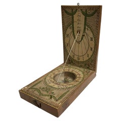
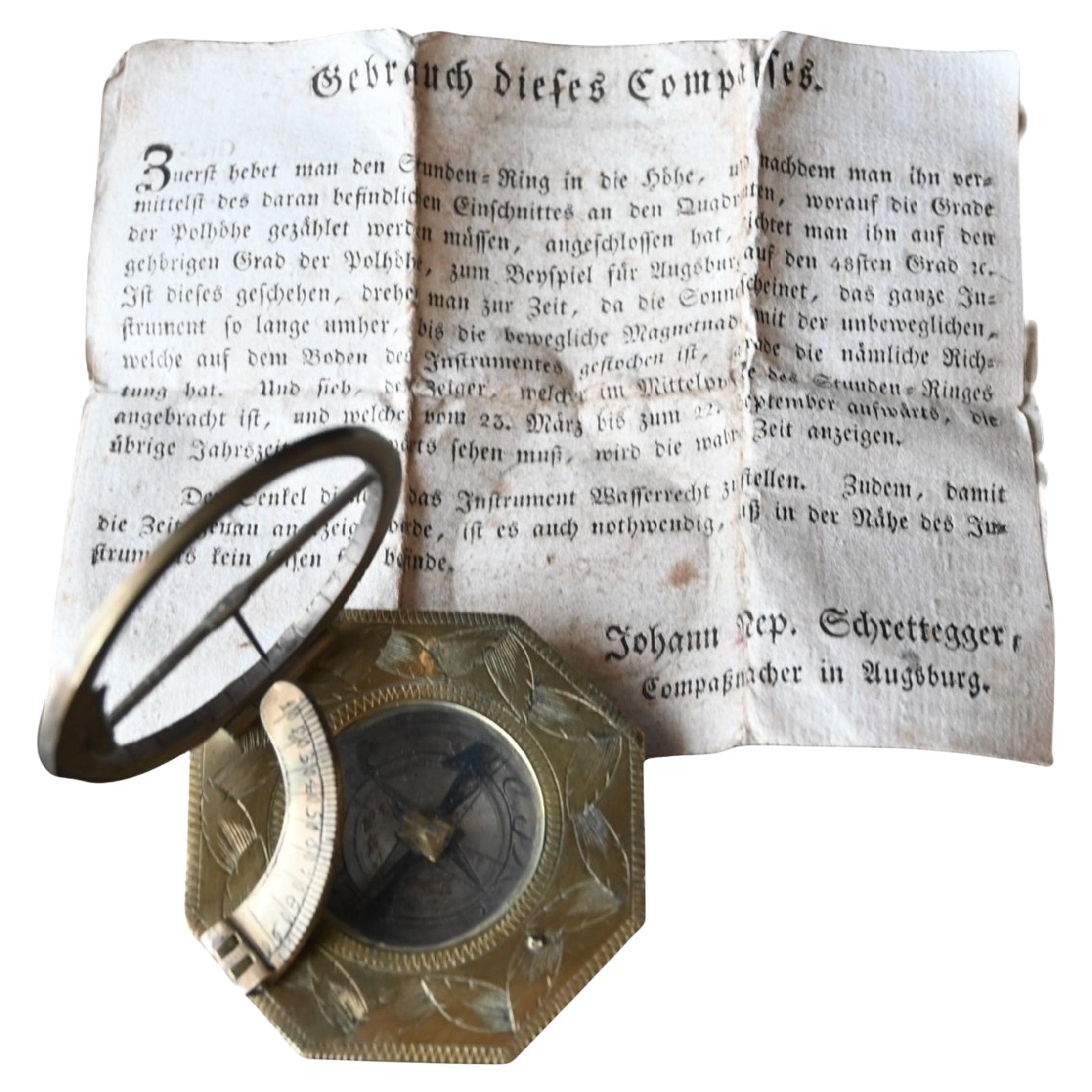
Rare 18th Century Equatorial Sundial And Compass By Johann Nepomuk Schrettegger
Located in Bilzen, BE
"Rare 18th Century Equatorial Sundial And Compass By Johann Nepomuk Schrettegger,"
Rare 18th-Century Equinoctial Sundial & Compass by Johann Nepomuk Schrettegger, Augsburg
Maker: Joh...
Category
Antique 18th Century German Louis XVI Scientific Instruments
Materials
Brass
More Ways To Browse
Antique Mechanical
Antique Brass H Hinges
Antique Brass Watch
Watchmaker Sign
Clock With 4 Faces
British Antique Clocks
Clock Reverse
Antique Mechanical Clocks
Oval Dial Watch
Hinged Case Watch
Antique Round Folding Table
Covered Face Watch
Nuremberg Silver
Baroque Vienna
European Watch And Clock
Nuremberg Brass
Antique Writing Instruments
Karl Springer Round Table