1 of 8
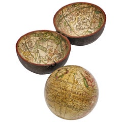
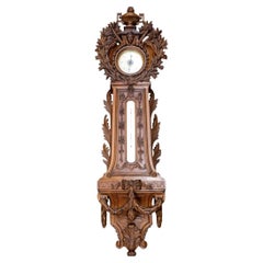
Unique Globe w/Clock, Barometer, Thermometer&Hygro(GMD#2728)
$1,050List Price
About the Item
- Dimensions:Height: 7.5 in (19.05 cm)Diameter: 5 in (12.7 cm)
- Materials and Techniques:
- Place of Origin:
- Period:
- Date of Manufacture:Mid 20th Century
- Condition:Good. Normal distress/patina/wear to piece/finish/materals of this age/use. Clock works and globe rotates easily. Contact dealer for full condition information.
- Seller Location:Los Angeles, CA
- Reference Number:Seller: 27281stDibs: U11040181851641
Authenticity Guarantee
In the unlikely event there’s an issue with an item’s authenticity, contact us within 1 year for a full refund. DetailsMoney-Back Guarantee
If your item is not as described, is damaged in transit, or does not arrive, contact us within 7 days for a full refund. Details24-Hour Cancellation
You have a 24-hour grace period in which to reconsider your purchase, with no questions asked.Vetted Professional Sellers
Our world-class sellers must adhere to strict standards for service and quality, maintaining the integrity of our listings.Price-Match Guarantee
If you find that a seller listed the same item for a lower price elsewhere, we’ll match it.Trusted Global Delivery
Our best-in-class carrier network provides specialized shipping options worldwide, including custom delivery.You May Also Like
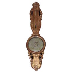
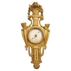
Louis XVI Style Giltwood Thermometer/ Barometer
Located in Montreal, QC
The Louis XVI style giltwood case with ribboned crest flanked by trailing garlands above the wood cased painted wheel barometer
Category
Antique 19th Century French Louis XVI Scientific Instruments
Materials
Giltwood, Glass
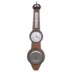
Victorian Marquetry Wall Barometer and Thermometer
Located in London, GB
Victorian marquetry wall barometer and thermometer.
English, 19th century
Measures: height 98cm, width 25cm, depth 7cm.
This elegant piece is a fin...
Category
Antique 19th Century English Victorian Scientific Instruments
Materials
Wood
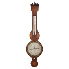
Mid-Century English Inlaid Burlwood Barometer / Thermometer
Located in Germantown, MD
Mid-Century English Inlaid Burlwood Barometer / Thermometer.
Clean vintage condition. Measures 8.5" in width, 33" in height and 2.25" in depth.
Category
Mid-20th Century English Mid-Century Modern Scientific Instruments
Materials
Wood
$1,242 Sale Price
30% Off
H 33 in W 8.5 in D 2.25 in
Monumental European Carved Wood Barometer And Thermometer
Located in Bradenton, FL
Large 19th Century Black Forest Thermometer Barometer combo featuring mounted in a wooden case, intricately hand-carved with a crowned face above the barometer, and beneath a buttres...
Category
Antique 19th Century German Black Forest Scientific Instruments
Materials
Wood
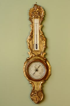
18th Century Parisian Giltwood Barometer Thermometer
Located in Dallas, TX
This lovely giltwood barometer and thermometer was hand-carved during the Louis XVI period in Paris, France. During the late 1700’s, barometers were typically only owned by wealthy families. Over time, barometers began to be viewed as works of art and could be found in middle class homes throughout Europe.
The highly detailed crown of our apparatus depicts a footed vase bursting with a floral display. The garland trails down in an arch shape until it reaches an angular platform adorned with molding and vertical fluting. The flowered swag continues behind the platform, transitioning into a pair of gadrooned leaves. Each gadrooned leaf terminates in a husked cornucopia overflowing with laurel leaves. A large circular barometer dial is positioned in between the cornucopias.
Under the barometer is a looping lambrequin that borders the top half of the thermometer. A pair of gadrooned leaves runs behind and through the lambrequin, flanking the lower half of the thermometer. A fluted base beneath the thermometer sits in a gadrooned cup.
The detail of the carvings on this late 18th century Parisian...
Category
Antique Late 18th Century French Louis XVI Scientific Instruments
Materials
Iron
Louis XV Period Gilded Barometer with Thermometer
Located in Pembroke, MA
An elegant French gilded wood barometer with thermometer (period Louis XV, Circa 1760). Barometer has been fitted with a new mercury tube, ...
Category
Antique 18th Century and Earlier French Louis XV Scientific Instruments
Materials
Giltwood, Glass
Regency Lane’s Pocket Globe, Dated 1818
By Lane's
Located in Lymington, Hampshire
A 3 ½ inch Regency Lane’s pocket globe, dated 1818, the terrestrial globe with the seas in light green and the land masses outlined in darker green, contained within a hinged black shagreen case, the concave interior of the case applied with the engraved celestial charts...
Category
Antique 1810s English Regency Globes
Materials
Wood
18-inch Globe, Cary's, London, 1840
By Cary’s
Located in Milano, IT
John and William Cary
Updated by George and John Cary
Terrestrial Globe
London, 1840
lb 22 (kg 10)
Slight surface abrasions due to use. A small crack on the horizon circle.
The globe rests in its original Dutch style stand with four supporting turned wood columns.
It measures 26 in in height x 23.6 in in diameter with the diameter of the sphere measuring 18 in; 66 cm in height x 60 cm in diameter with the diameter of the sphere measuring 45.72 cm.
The 18 inch...
Category
Antique 1840s English Early Victorian Globes
Materials
Paper, Wood
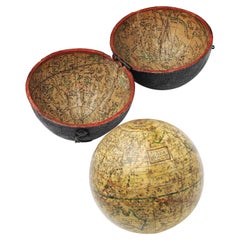
English Pocket Globe, London, Circa 1775-1798
By Herman Moll
Located in Milano, IT
Pocket globe
London, between 1775 and 1798
Re-edition of the globe of Hermann Moll (1678-1732) dated 1719
The globe is contained in its original case, which itself is covered in shark skin.
There are slight gaps in the original paint on the sphere. The case no longer closes.
The sphere measures 2.7 in (7 cm) in diameter whereas the case measures 2.9 in (7.4 cm) in diameter.
lb 0.22 (kg 0.1)
The globe is made up of twelve printed paper gores aligned and glued to the sphere.
In the North Pacific Ocean there is a cartouche with the inscription:
A Correct
Globe
with the new
Discoveries.
The celestial globe is depicted on the inside of the box and is divided into two hemispheres with the cartouche:
A correct globe
with ye new cons
relations of Dr.
Halley & c.
It shows the ecliptic divided into the days of the zodiacal calendar and the constellations represented as animals and mythological figures.
On the globe are delineated the equinoctial line, divided by degrees and hours, the ecliptic and the meridian (passing west of Greenwich). The continents are shaded and outlined in pink, green and yellow. It shows: the Cook routes; a wind rose in the Southern Indian Ocean; Antarctica without land; Africa with Negroland (Hermann Moll is considered the first geographer to name the West African region in his 1727 map. (Encyclopaedia Britannica, ed. 1902, under "States of Central Africa"); Tartary in Central Asia; the Mogul kingdom in northern India; in North America only New England, Virginia, Carolina, Florida, Mississippi are identified; California is already a peninsula; the northwest coast of America is "unknown parts" (Alaska is not described and it is only partially delineated, it was to become part of the United States in 1867); Mexico is named "Spain"; Central South America "Amazone America". Australia (which was to be so named after 1829) is called New Holland. The route of Admiral Anson is traced (1740) and the trade winds are indicated by arrows. (See Van der Krogt, P., Old Globes in the Netherlands, Utrecht 1984, p. 146 and Van der Krogt, P. - Dekker, E., Globes from the Western World, London 1993, pp. 115.)
Elly Dekker, comparing Moll’s 1719 globe and his re-edition (of which the one described above is a sample), identifies the differences between them: the two editions are quite similar to each other, but in the "anonymous" globe, compared to the previous globe of 1719, California looks like a proper peninsula - the reports of the Spanish explorers of the region had given rise to uncertainty over whether it was connected to the mainland or not. The geographical nature of California was confirmed after the explorations of Juan Bautista de Anza (1774-1776). The routes of Dampier's journey were partially erased and the route of Captain James Cook's first voyage was superimposed on them, and the geography of Australasia was adapted accordingly, including the denomination of the Cook Strait. See Dekker, Elly, Globes at Greenwich, 1999.
An important ante quem element is represented by Tasmania: it is not separated from Australia by the Bass Strait...
Category
Antique Late 18th Century English George III Globes
Materials
Shagreen, Paper
Pocket Globe by Nathaniel Hill, London 1754
Located in Milano, IT
Nathaniel Hill
Pocket globe
London, 1754
The globe is contained in its original case, which itself is covered in shark skin.
There are slight gaps in the original paint on the sphere. The case no longer closes.
The sphere measures 2.6 in (6.8 cm) in diameter whereas the case measures 2.9 in (7.4 cm) in diameter.
lb 0.24 (kg 0.11)
The globe is made up of twelve printed paper gores aligned and glued to the sphere.
In the North Pacific Ocean there is a scroll with the inscription:
A
New
terrestrial
Globe
by
Nath. Hill,
1754.
The celestial globe is depicted on the inside of the box.
On the terrestrial globe much of central and southern Africa is empty. North America bears only the name of some British colonies. It shows California as a peninsula and the northwest coast of America as "unknown parts" (Alaska is not described and is only partially delineated; it would become part of the United States in 1867). The route of Admiral Anson is traced (1740) and the trade winds are indicated by arrows. Australia, still named New Holland (the new name would be introduced in 1829), is part of the west coast. (See Van der Krogt, P., Old Globes in the Netherlands, Utrecht 1984, p. 146 and Van der Krogt, P. - Dekker, E., Globes from the Western World, London 1993, p. 115.)
Nathaniel Hill (London, news from 1746 to 1768) had impeccable professional credentials: he had done his apprenticeship with Richard Cushee, who at the time was carrying out surveying work for John Senex's Surrey map...
Category
Antique 1750s English George II Globes
Materials
Shagreen, Paper