Items Similar to Original 1948 Map of Uruguay by Charles Burki – Art Deco Design


Want more images or videos?
Request additional images or videos from the seller
1 of 9
Original 1948 Map of Uruguay by Charles Burki – Art Deco Design
$652.32
£489.66
€550
CA$912.59
A$998.81
CHF 519.19
MX$12,021.05
NOK 6,527.01
SEK 6,122.53
DKK 4,190.31
About the Item
Title: Original 1948 Map of Uruguay by Charles Burki – Art Deco Design for Liebig Extract
This original 1948 pen-and-ink map of Uruguay by Charles Burki (1909–1994) showcases his refined sense of composition and command of graphic clarity, blending geography, commercial illustration, and early postwar design. Created for the Liebig Extract of Meat Company, it highlights Uruguay’s agricultural wealth and export economy in an elegant Art Deco-inspired layout that merges precision mapping with striking visual detail.
The map presents Uruguay’s major cities, rivers, and trade routes with clean linework and careful lettering. Around the borders, Burki added illustrative vignettes symbolizing the country’s key products: a detailed cow’s head among stalks of wheat, a Merino sheep on the opposite side, and depictions of maize, canned beef marked “Beef – Liebig,” and a bottle labeled “Aroma Liebig.” These images represent Uruguay’s principal exports of beef, hides, wool, and grain, rendered with Burki’s characteristic precision. An airplane, compass rose, and stylized marlin evoke movement, trade, and the connection between land and sea.
This map is signed and dated “Charles Burki 48” in the lower right corner, marking the artist’s active postwar period when he worked for Dutch publishers such as Uitgeverij Succes, producing illustrations and educational maps that combined clarity with artistic appeal. The inclusion of advertising elements such as the Liebig branding reflects his ability to merge commercial and informational design without losing aesthetic balance.
The depth and empathy in Burki’s postwar work are inseparable from his extraordinary personal history. Born in the Dutch East Indies, he was imprisoned during World War II by Japanese forces, survived the sinking of a transport ship, and endured the atomic bombing of Nagasaki. These traumatic experiences profoundly influenced his artistic outlook, sharpening both his technical discipline and his awareness of human endurance. After the war, Burki resettled in the Netherlands, channeling his resilience into illustration, architecture, and teaching. His work often carries a quiet strength and precision born from survival and reflection.
In this map, Burki’s meticulous draughtsmanship conveys more than cartography—it reflects order, renewal, and progress after chaos. The composition is balanced and optimistic, celebrating productivity, trade, and human industry in a world rebuilding after war.
Condition report: Very good condition with light toning and minor handling traces consistent with age. Small pieces of archival mounting tape are visible on the margins. The ink and linework remain crisp and bold.
Framing suggestion: A simple black or dark oak frame with an off-white mat enhances the clarity of the linework and complements the vintage cream paper tone.
Technique: Pen and ink on paper
Maker: Charles Burki (Dutch-Indonesian, 1909–1994), signed and dated 1948
- Dimensions:Height: 12.92 in (32.8 cm)Width: 9.53 in (24.2 cm)Depth: 0.01 in (0.2 mm)
- Materials and Techniques:
- Place of Origin:
- Period:
- Date of Manufacture:1948
- Condition:Condition report: Very good condition with light toning and minor handling traces consistent with age. Small pieces of archival mounting tape are visible on the margins. The ink and linework remain crisp and bold.
- Seller Location:Langweer, NL
- Reference Number:Seller: BG-Bea351stDibs: LU3054347183672
About the Seller
5.0
Recognized Seller
These prestigious sellers are industry leaders and represent the highest echelon for item quality and design.
Platinum Seller
Premium sellers with a 4.7+ rating and 24-hour response times
Established in 2009
1stDibs seller since 2017
2,689 sales on 1stDibs
Typical response time: <1 hour
- ShippingRetrieving quote...Shipping from: Langweer, Netherlands
- Return Policy
Authenticity Guarantee
In the unlikely event there’s an issue with an item’s authenticity, contact us within 1 year for a full refund. DetailsMoney-Back Guarantee
If your item is not as described, is damaged in transit, or does not arrive, contact us within 7 days for a full refund. Details24-Hour Cancellation
You have a 24-hour grace period in which to reconsider your purchase, with no questions asked.Vetted Professional Sellers
Our world-class sellers must adhere to strict standards for service and quality, maintaining the integrity of our listings.Price-Match Guarantee
If you find that a seller listed the same item for a lower price elsewhere, we’ll match it.Trusted Global Delivery
Our best-in-class carrier network provides specialized shipping options worldwide, including custom delivery.More From This Seller
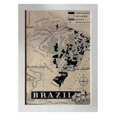
View AllOriginal 1947 Map of Brazil by Charles Burki – Dutch Colonial Graphic Design
Located in Langweer, NL
Original 1947 Map of Brazil by Charles Burki – Dutch Colonial Graphic Design
This original 1947 pen-and-ink map of Brazil by Charles Burki (1909–1994) exemplifies the artist’s preci...
Category
Vintage 1940s Dutch Drawings
Materials
Paper
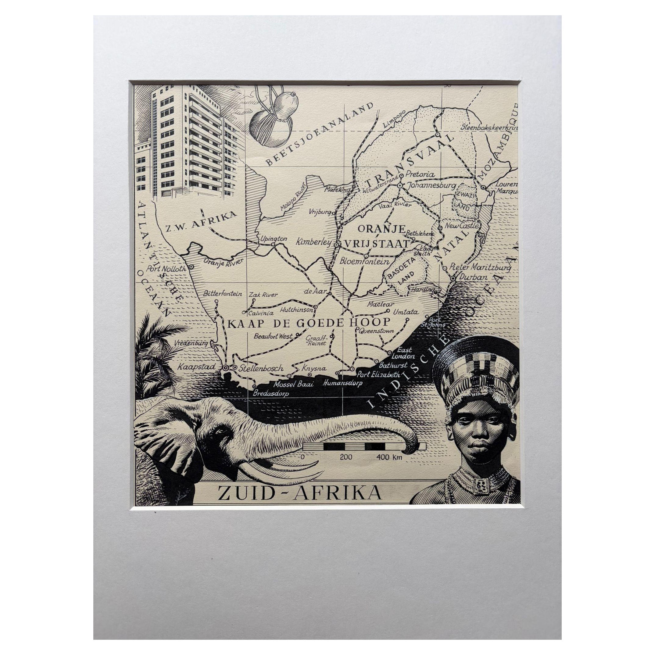
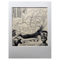
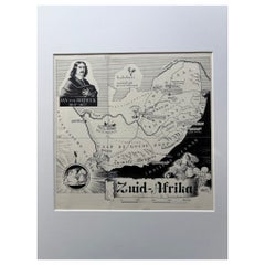
Original Illustration Map of South Africa by Charles Burki, c.1945 – Ink Drawing
Located in Langweer, NL
Original Illustration Map of South Africa by Charles Burki, ca. 1945 – Ink Drawing
Description:
Original pen-and-ink illustration of Zuid-Afrika (South Africa) by Dutch artist Charl...
Category
Vintage 1940s Dutch Drawings
Materials
Paper
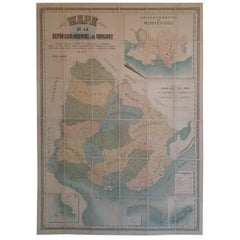
Cortesi's Masterpiece: A Comprehensive and Authoritative Map of Uruguay, 1903
Located in Langweer, NL
Antique map titled 'Mapa de la Republica Oriental del Uruguay'. Large and detailed folding map of Uruguay. This monumental map depicts all of Uruguay with unprecedented accuracy and detail. Impressively, it serves the multiple roles of being an advanced topographic, economic and political map, as well as being a meticulous sea chart of the Rio de la Plata and the adjacent waters of the Atlantic. The republic's 20 departments are defined in various colors, while a legend, 'Referencias' identifies symbols representing the locations of departmental capitals, town, roads, railways, public schools and lighthouses, amongst other details. Every single river and stream is delineated and named and the ridges of hills are delicately expressed. The map features four insets, including a large map of the capital, Montevideo, as well as maps of Colonia, Maldonado and Punta del Este and the Island of Flores. The hydrographical information provided is truly profound, and renders the map fit for use in maritime commerce.
In 1901, the Uruguayan House of Representatives commissioned the geographer Saturnino Cortesi to employ the most progressive geographical sources, both military and civilian, to devise an authoritative national map of the republic. Cortesi clearly had access to a vast archive of topographical surveys...
Category
Early 20th Century Maps
Materials
Paper
$5,218 Sale Price
20% Off
Free Shipping
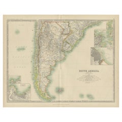
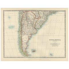
Antique Map of South America by Johnston '1909'
Located in Langweer, NL
Antique map titled 'South America, Southern Sheet'. Depicting Chile, Argentina, Brazil, Patagonia, the Falkland Island and more. With inset maps of Valparaiso, Rio de Janeiro and Bue...
Category
Early 20th Century British Maps
Materials
Paper
$237 Sale Price
20% Off
Map of Southern South America – Richly Detailed Engraving by K.Johnston, 1903
Located in Langweer, NL
Title (80 characters, keyword-first):
Map of Southern South America – Richly Detailed Engraving by Keith Johnston, 1903
Description:
This elegant map titled "South America: Southern...
Category
Early 20th Century Maps
Materials
Paper
Original 1947 Map of South Africa by C. Burki – Jan van Riebeeck & Cape Colony
Located in Langweer, NL
Title: Original 1947 Map of South Africa by Charles Burki – Jan van Riebeeck & Cape Colony
This striking 1947 pen-and-ink map of South Africa by Charles Burki (1909–1994) exemplifie...
Category
Vintage 1940s Dutch Drawings
Materials
Paper
You May Also Like
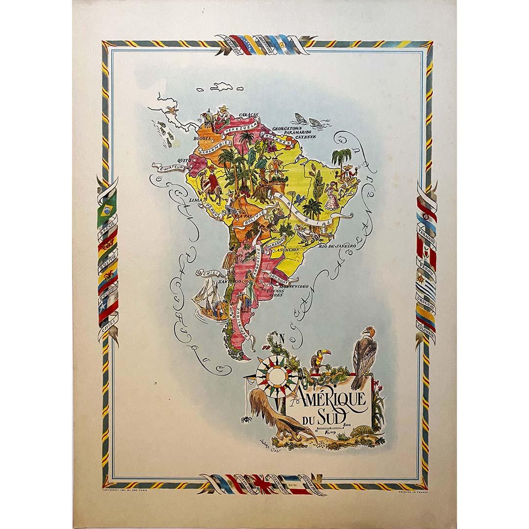
Jacques Liozu's 1951 illustrated map of South America
By Jacques Liozu
Located in PARIS, FR
Jacques Liozu's 1951 illustrated map of South America is an exceptional work of cartography that skilfully blends art and geography. French artist and cartographer Jacques Liozu crea...
Category
1950s Prints and Multiples
Materials
Lithograph, Paper

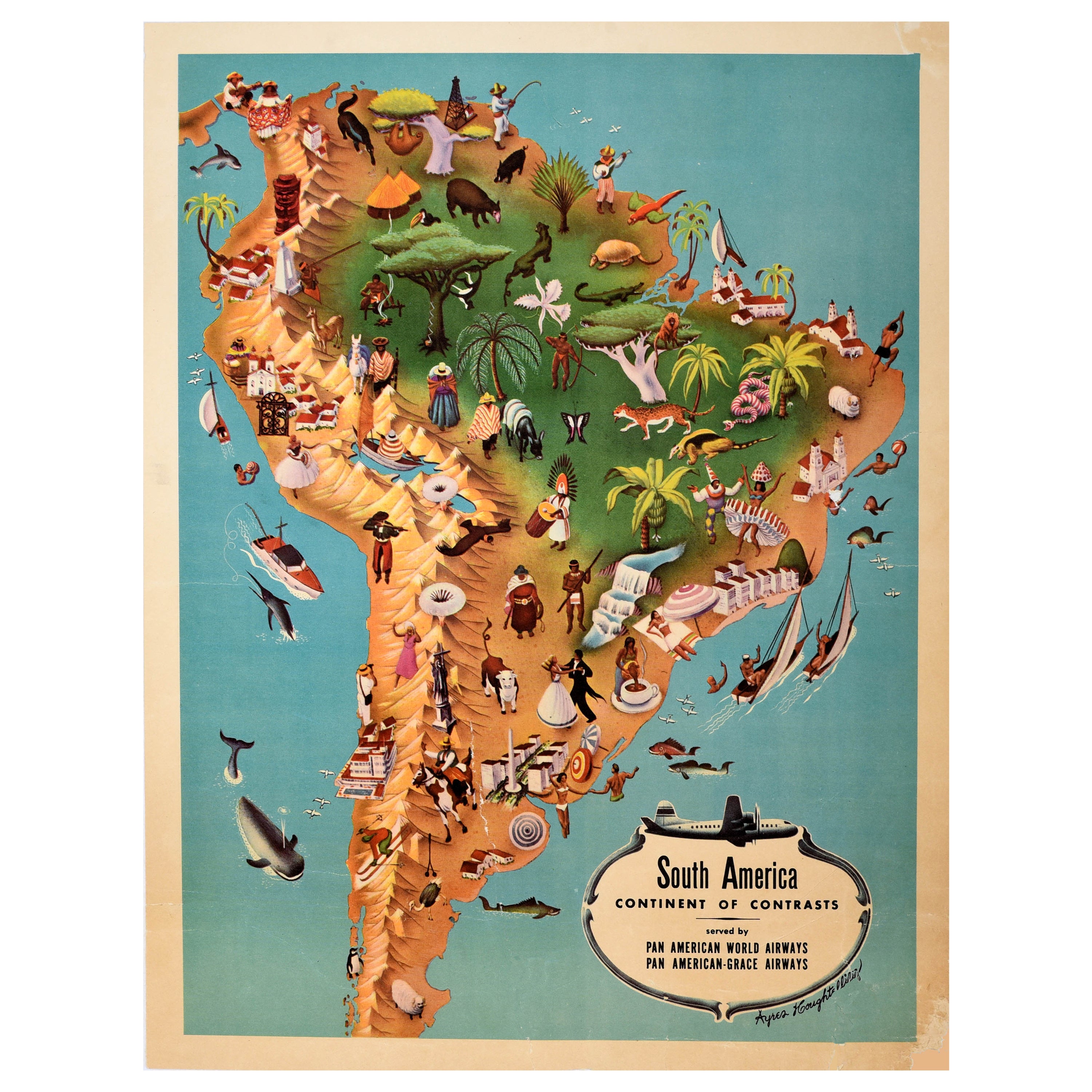
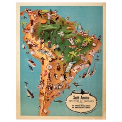
Original Vintage Pan Am Travel Map Poster South America Continent Of Contrasts
Located in London, GB
Original vintage Pan Am travel advertising map poster - South America Continent of Contrasts served by Pan American World Airways and Pan American Grace ...
Category
Vintage 1940s American Posters
Materials
Paper
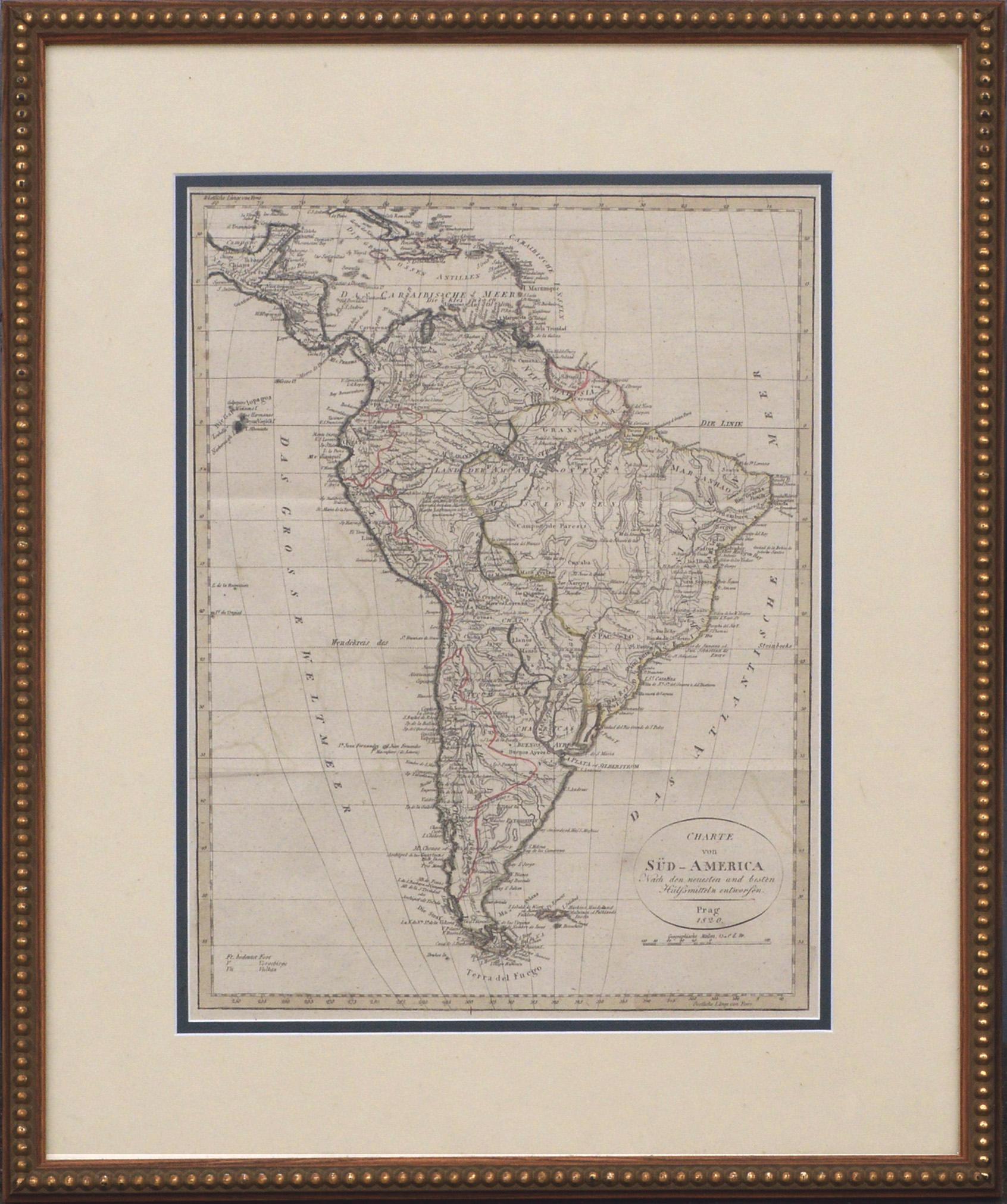
Charte von Sud-America (Map of South America) - Etching with Hand-Drawn Outlines
Located in Soquel, CA
Map of south America, engraved by Franz Pluth (Czech, 1800-1871), from the book "Neueste Länder - und Völkerkunde, ein geographisches Lesebuch für alle Stände" by Linder, F. L. (Prag...
Category
1820s Other Art Style More Prints
Materials
Paper, Printer's Ink, Etching

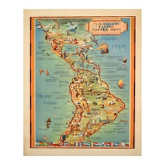
Original Vintage Travel Poster Pan Am Flying Clipper Ships South America Map
Located in London, GB
Original vintage Pan Am travel advertising map poster - On the routes of the Flying Clipper Ships - featuring a pictorial map by Kenneth W. Thompson (1907-1996) of Latin America with images of points of interest, cities, animals and people including ancient Maya ruins and Inca ruins, the Iguassu Falls, Amazon...
Category
Vintage 1940s American Posters
Materials
Paper
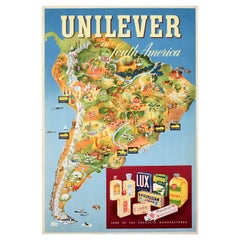
Original Vintage Advertising Poster Unilever South America Illustrated Map Art
Located in London, GB
Original vintage advertising poster for Unilever in South America featuring a colourful illustrated map marking the factories - Lever & Atkinson Lima Peru / Atkinson Santiago Chile / Lever Atkinson Buenos Aires Argentina / Atkinson Montevideo Uruguay / Lever Sao Paolo and Atkinson Rio de Janeiro Brazil - with images of people, industry and cattle farming, forests, wine production, mountains, sheep and cows, wheat, fruit, fishing, wild animals and birds, flowers, whales, a penguin and seal, a raft, sailing boat and ship at sea, the bold title above and a box below showing some of the cleaning and other household products manufactured including Lux, Rinso, Pepsodent toothpaste, Olavino and Sunlight soap. The British company Lever Brothers...
Category
Vintage 1950s British Posters
Materials
Paper
Antique Map of South America in Roma Frame
Located in Malibu, CA
Antique map of South America. Displayed in a new Roma frame with museum quality matting. Custom frame in platinum. No print date, but cert...
Category
Antique Late 19th Century Victorian Prints
Materials
Paper, Hardwood

$300 Sale Price
20% Off