Items Similar to Antique Chart of the Southern Pole, Showing Three Routes of Captain Cook, 1803

Want more images or videos?
Request additional images or videos from the seller
1 of 5
Antique Chart of the Southern Pole, Showing Three Routes of Captain Cook, 1803
$924.82
$1,156.0220% Off
£684.25
£855.3120% Off
€768
€96020% Off
CA$1,278.72
CA$1,598.4020% Off
A$1,403.88
A$1,754.8520% Off
CHF 732.41
CHF 915.5120% Off
MX$16,988.86
MX$21,236.0820% Off
NOK 9,179.57
NOK 11,474.4620% Off
SEK 8,649.56
SEK 10,811.9620% Off
DKK 5,847.57
DKK 7,309.4720% Off
About the Item
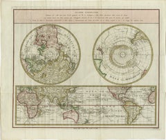
Antique map titled 'Kaart van het Zuider Halfrond'. Circular chart within a square frame centred on the southern pole. It shows southern parts of South America, South Africa and Madagascar as well as Australia and part of Indonesia. Originates from 'Reizen Rondom de Waereld door James Cook (..)'.
Artists and Engravers: Translated by J.D. Pasteur. Published by Honkoop, Allart en Van Cleef.
Condition: Very good, minor defects and some small professional restorations. Please study image carefully.
Date: 1803
Overall size: 73.5 x 61 cm
Image size: 52 x 53 cm
We also offer thousands of antique prints covering fields of interest as diverse as architecture, natural history, religion, ethnology and many more. Antique prints have long been appreciated for both their aesthetic and investment value. They were the product of engraved, etched or lithographed plates. These plates were handmade out of wood or metal, which required an incredible level of skill, patience and craftsmanship. Whether you have a house with Victorian furniture or more contemporary decor an old engraving can enhance your living space.
- Dimensions:Height: 24.02 in (61 cm)Width: 28.94 in (73.5 cm)Depth: 0 in (0.01 mm)
- Materials and Techniques:
- Period:
- Date of Manufacture:1803
- Condition:
- Seller Location:Langweer, NL
- Reference Number:Seller: BG-11487-31stDibs: LU3054325894882
About the Seller
5.0
Recognized Seller
These prestigious sellers are industry leaders and represent the highest echelon for item quality and design.
Platinum Seller
Premium sellers with a 4.7+ rating and 24-hour response times
Established in 2009
1stDibs seller since 2017
2,641 sales on 1stDibs
Typical response time: <1 hour
- ShippingRetrieving quote...Shipping from: Langweer, Netherlands
- Return Policy
Authenticity Guarantee
In the unlikely event there’s an issue with an item’s authenticity, contact us within 1 year for a full refund. DetailsMoney-Back Guarantee
If your item is not as described, is damaged in transit, or does not arrive, contact us within 7 days for a full refund. Details24-Hour Cancellation
You have a 24-hour grace period in which to reconsider your purchase, with no questions asked.Vetted Professional Sellers
Our world-class sellers must adhere to strict standards for service and quality, maintaining the integrity of our listings.Price-Match Guarantee
If you find that a seller listed the same item for a lower price elsewhere, we’ll match it.Trusted Global Delivery
Our best-in-class carrier network provides specialized shipping options worldwide, including custom delivery.More From This Seller
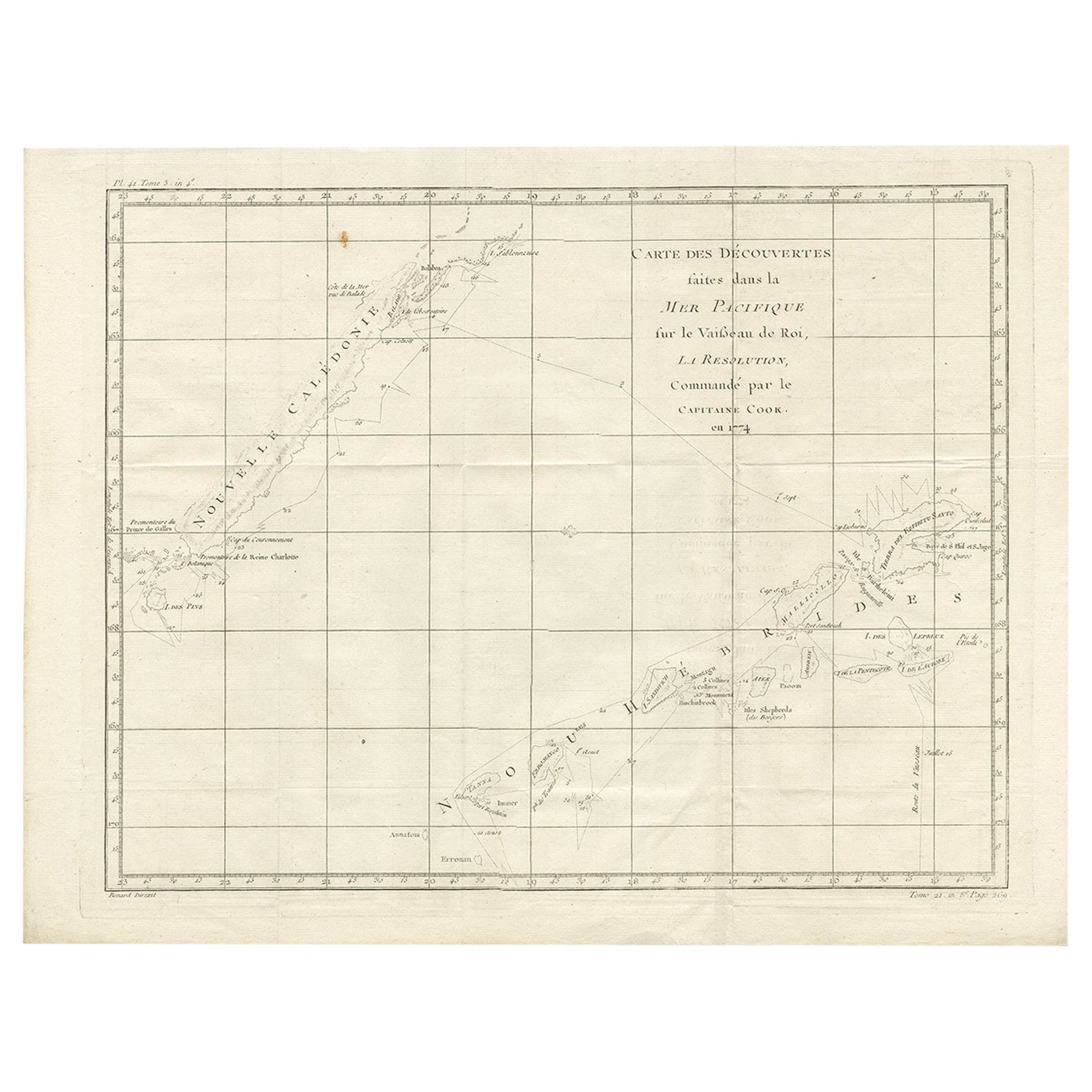
View AllAntique Chart of the Voyage of Captain Cook by Benard, 1780
Located in Langweer, NL
Antique map titled 'Carte des Découvertes faites dans la Mer Pacifique sur la Vaisse au de Roi, La Resolution, Commandé par le Capitaine Cook en 1774'. Chart detailing the 1774 voyag...
Category
Antique 18th Century Maps
Materials
Paper
$269 Sale Price
20% Off
Old World Map Featuring Captain Cook's Exploration Routes and Polar Views, 1787
Located in Langweer, NL
1786 World Map with Polar Projections - "Globo Terrestre" by Giovanni Maria Cassini
This 1786 map titled "Globo Terrestre" by Giovanni Maria Cassini offers a fascinating and detai...
Category
Antique 1860s Maps
Materials
Paper
$1,830 Sale Price
20% Off
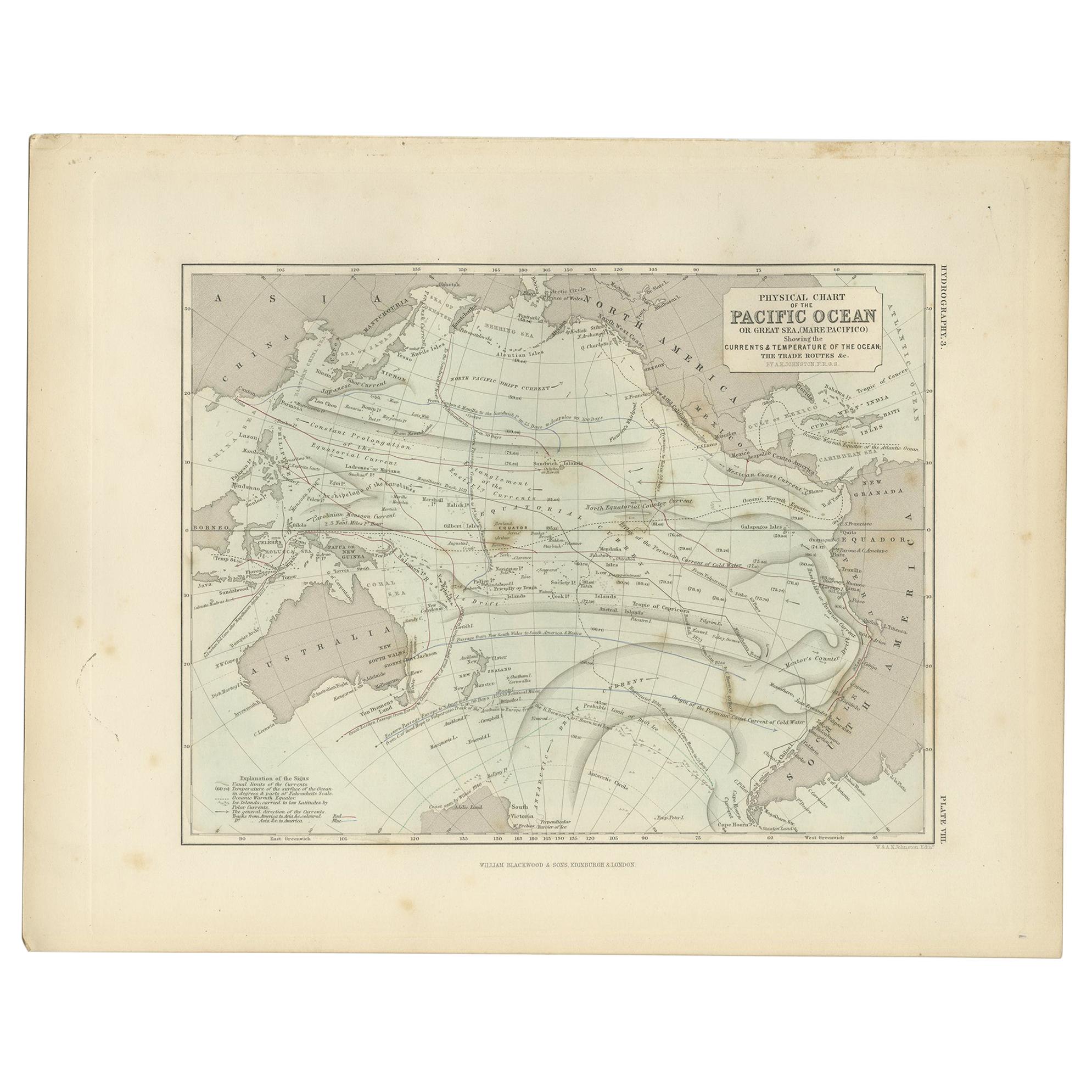
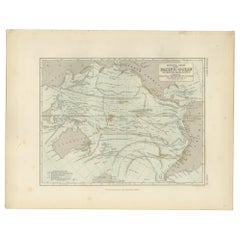
Antique Physical Chart of the Pacific Ocean by Johnston, '1850'
Located in Langweer, NL
Antique map titled 'Physical Chart of the Pacific Ocean showing the currents and temperature of the ocean'. Original antique chart of the Pacific Ocean. This map originates from 'The...
Category
Antique Mid-19th Century European Maps
Materials
Paper
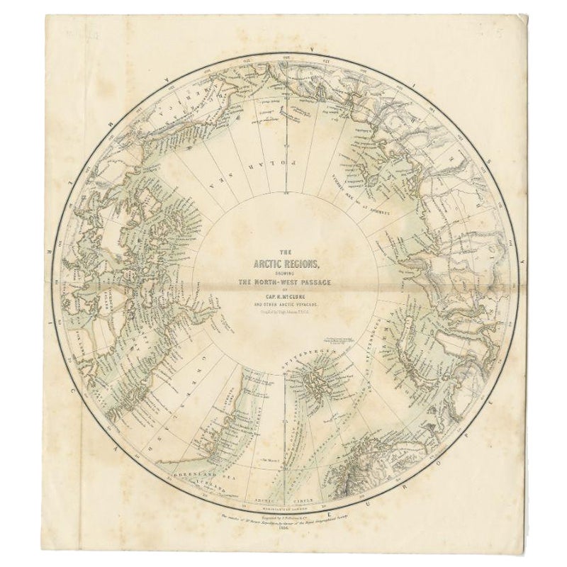
Antique Map of the North Pole by Fullarton, 1856
Located in Langweer, NL
Antique map titled 'The Arctic Regions showing the North-West Passage of Captain R. McClure'. Old map of the North Pole, displaying the Northwest Passage di...
Category
Antique 19th Century Maps
Materials
Paper
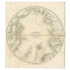
$122 Sale Price
20% Off
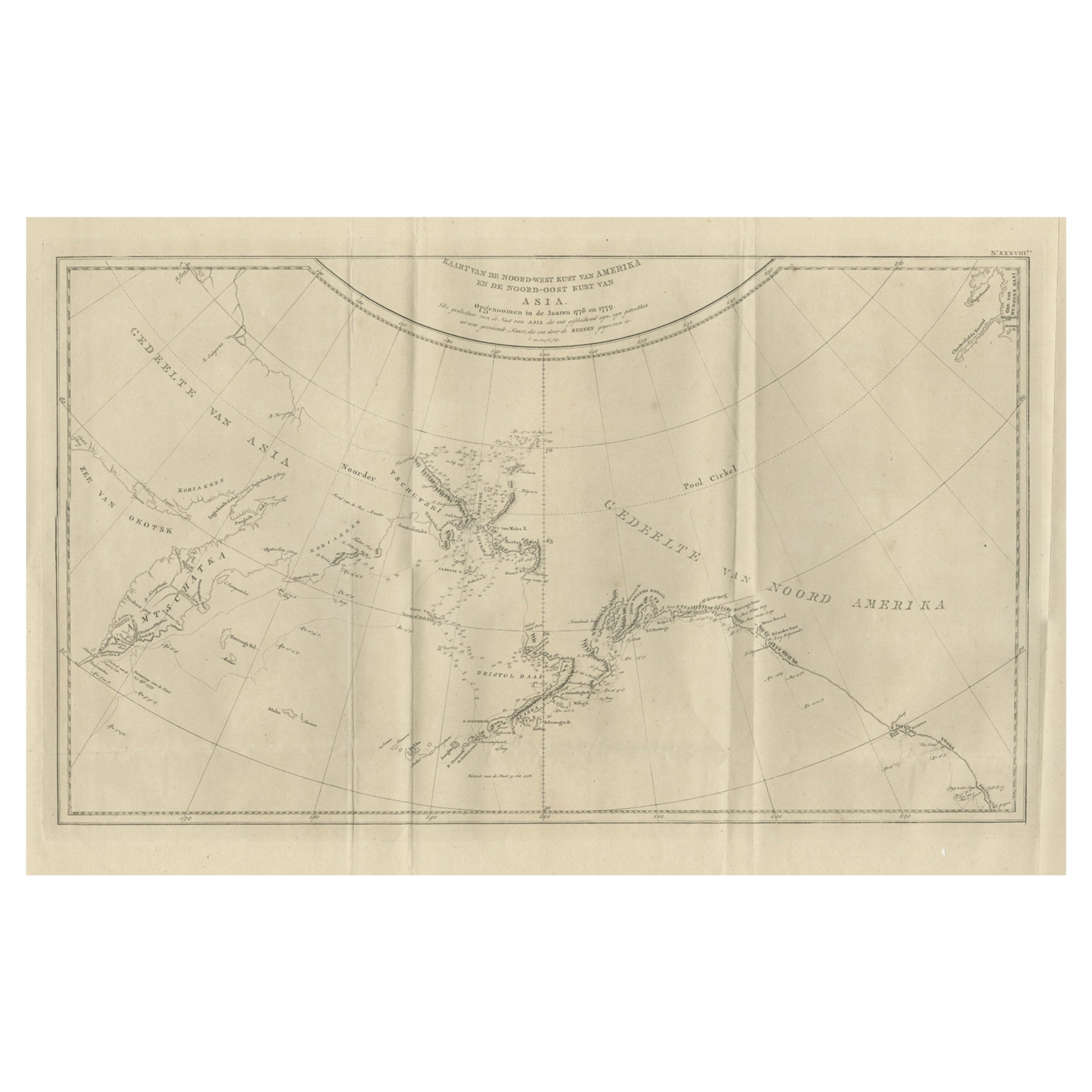
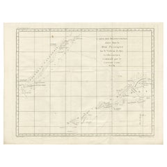
Old Map Showing the Tracks of Cook Between North America and Asia's Coast, 1803
Located in Langweer, NL
Description: Antique map titled 'Kaart van de Noord-West kust van Amerika en de Noord-Oost kust van Asia'.
Antique chart depicting America's northwest coast and Asia's northeast ...
Category
Antique Early 1800s Maps
Materials
Paper
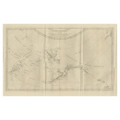
$915 Sale Price
20% Off
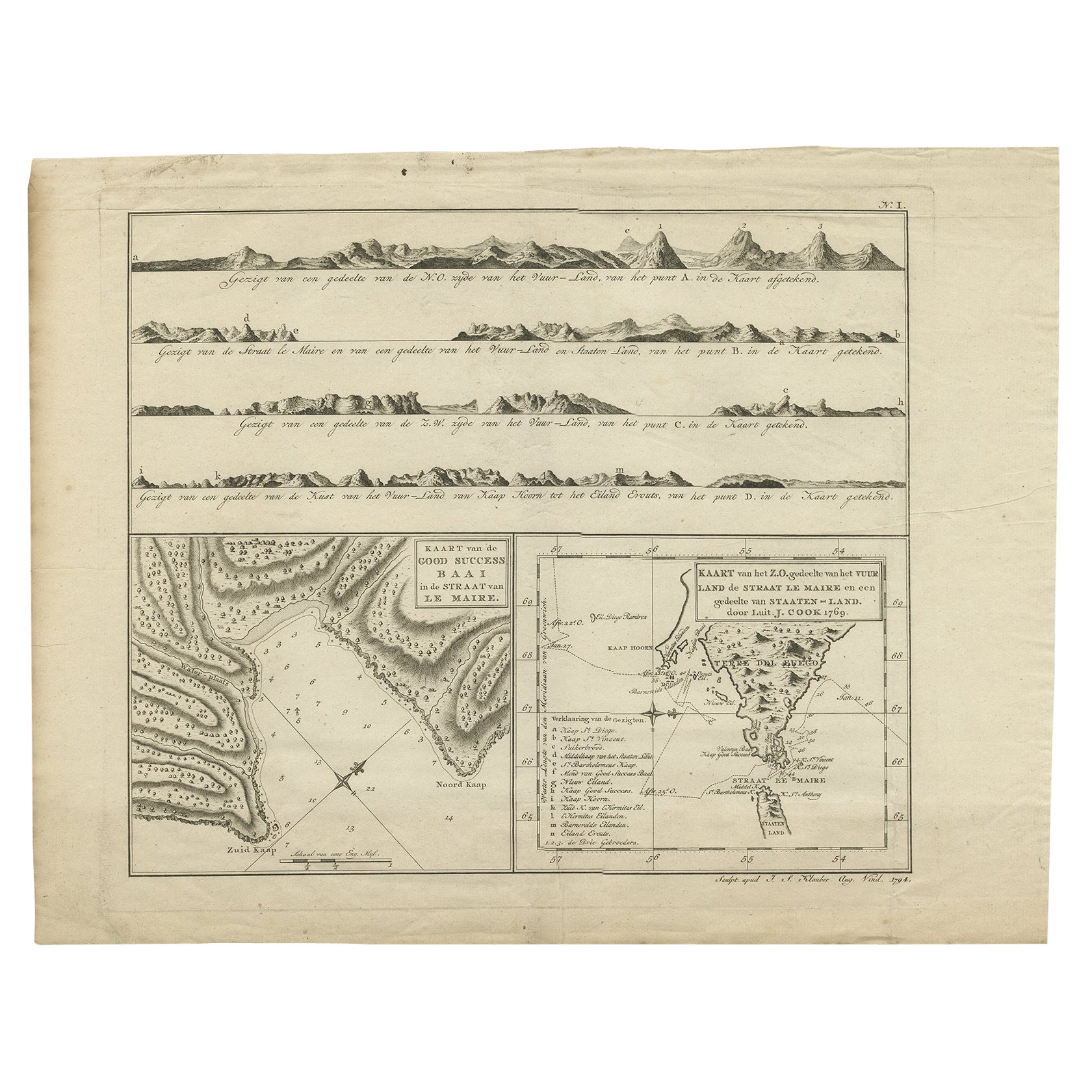
Antique Map of the Strait of Le Maire by Cook, 1803
Located in Langweer, NL
Antique map titled 'Kaart van de Good Success Baai in de Straat van Le Maire (..)'. Antique map of the Strait of Le Maire between Terra Fuego and Staten Island. On top, various coast...
Category
Antique 19th Century Maps
Materials
Paper

$606 Sale Price
20% Off
You May Also Like
Original Antique Map of The Eastern Hemisphere by Dower, circa 1835
Located in St Annes, Lancashire
Nice map of the Eastern Hemisphere
Drawn and engraved by J.Dower
Published by Orr & Smith. C.1835
Unframed.
Free shipping
Category
Antique 1830s English Maps
Materials
Paper

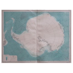
Large Original Vintage Map of the South Pole, circa 1920
Located in St Annes, Lancashire
Great map of the South pole.
Unframed.
Original color.
By John Bartholomew and Co. Edinburgh Geographical Institute.
Published, circa 1920.
Category
Vintage 1920s British Maps
Materials
Paper
Original Antique Map of The Western Hemisphere by Dower, circa 1835
Located in St Annes, Lancashire
Nice map of the Western Hemisphere
Drawn and engraved by J.Dower
Published by Orr & Smith. C.1835
Unframed.
Free shipping
Category
Antique 1830s English Maps
Materials
Paper

Original Antique Map of The World by Thomas Clerk, 1817
Located in St Annes, Lancashire
Great map of The Eastern and Western Hemispheres
On 2 sheets
Copper-plate engraving
Drawn and engraved by Thomas Clerk, Edinburgh.
Published by Mackenzie And Dent, 1817
...
Category
Antique 1810s English Maps
Materials
Paper

Ancient Map of Oceania - Original Etching - 19th century
Located in Roma, IT
This Map of Oceania is an etching realized in the 19th century.
The state of preservation of the artwork is good. At the top of the paper, the inscription “Longitudine del Meridiano...
Category
19th Century More Prints
Materials
Etching

Original Antique Map of South America. C.1780
Located in St Annes, Lancashire
Great map of South America
Copper-plate engraving
Published C.1780
Two small worm holes to left side of map
Unframed.
Category
Antique Early 1800s English Georgian Maps
Materials
Paper

More Ways To Browse
Swedish Botanical Print
Toni Hermansson
Trowbridge Botanical Print
Tugomir Huberger
Van Gogh Cafe Terrace
Vanity Fair Original Print
Vasarely Griffon
Vintage Botanical Rose Prints
Vintage Paris Map Framed
Vintage Wall Registers
1940s French Prints
1961 Picasso Exhibition
Aaa Lithograph
Alexander Wilson Birds
Antique Painting Pompeii
Arman Boom Boom
Audubon Havell Edition
Audubon Havell