Items Similar to Antique Map of Principality of Monaco


Want more images or videos?
Request additional images or videos from the seller
1 of 6
Antique Map of Principality of Monaco
$450.70
£338.31
€380
CA$630.52
A$690.09
CHF 358.71
MX$8,305.45
NOK 4,509.57
SEK 4,230.11
DKK 2,895.12
About the Item
ST/619 - "Old Geographical Atlas of Italy - Topographic map of ex-Principality of Monaco" -
ediz Vallardi - Milano -
A somewhat special edition ---
- Creator:Antonio Vallardi Editore (Illustrator)
- Dimensions:Height: 22.84 in (58 cm)Width: 15.75 in (40 cm)Depth: 0.04 in (1 mm)
- Style:Other (In the Style Of)
- Materials and Techniques:Paper,Other
- Place of Origin:
- Period:
- Date of Manufacture:1859
- Condition:
- Seller Location:Alessandria, IT
- Reference Number:1stDibs: LU1379223166852
About the Seller
4.8
Vetted Professional Seller
Every seller passes strict standards for authenticity and reliability
Established in 1984
1stDibs seller since 2015
375 sales on 1stDibs
Typical response time: 11 hours
- ShippingRetrieving quote...Shipping from: Alessandria, Italy
- Return Policy
Authenticity Guarantee
In the unlikely event there’s an issue with an item’s authenticity, contact us within 1 year for a full refund. DetailsMoney-Back Guarantee
If your item is not as described, is damaged in transit, or does not arrive, contact us within 7 days for a full refund. Details24-Hour Cancellation
You have a 24-hour grace period in which to reconsider your purchase, with no questions asked.Vetted Professional Sellers
Our world-class sellers must adhere to strict standards for service and quality, maintaining the integrity of our listings.Price-Match Guarantee
If you find that a seller listed the same item for a lower price elsewhere, we’ll match it.Trusted Global Delivery
Our best-in-class carrier network provides specialized shipping options worldwide, including custom delivery.More From This Seller
View AllGeographical Antique Map of Principality of Monaco
By Bruno Santini
Located in Alessandria, Piemonte
ST/609 - Interesting antique color map of Monaco Principality in French language : "Carte qui contient le Principauté de Piémont, le Monferrat et la comté de...
Category
Antique Late 18th Century Italian Other Maps
Materials
Paper

Ancient National Atlas of France with Marengo
Located in Alessandria, Piemonte
Ancient National Atlas of France with the department of Marengo: a rare French etching dated 1806.
ST/178.
Category
Antique Early 19th Century French Other Prints
Materials
Paper

Geographical Map of Italy
Located in Alessandria, Piemonte
BOLIS Publishing House - Bergamo.
A beautiful large map of Italy, on paper but suitably reinforced to preserve it correctly. The maps were usually p...
Category
Mid-20th Century Italian Other Prints
Materials
Paper

Old Horizontal Map of England
By Tasso
Located in Alessandria, Piemonte
ST/520 - Old rare Italian map of England, dated 1826-1827 - by Girolamo Tasso, editor in Venise, for the atlas of M.r Le-Sage.
Category
Antique Early 19th Century Italian Other Prints
Materials
Paper

Map "Estuary- Mouth of the Thames"
Located in Alessandria, Piemonte
ST/426 - Antique French Map of the estuary of the Thames, map dated 1769 -
"Mape of the entrance of the Thames. Designed by filing of Navy cards fo...
Category
Antique Mid-18th Century French Other Prints
Materials
Paper

Ancient Valenza Jewelry City Etching
Located in Alessandria, Piemonte
Ancient etching from 1707 representing VALENZA, the Italian city in the province of Alessandria, famous throughout the world for its gold processing any jewelry factories.
Author of ...
Category
Antique Early 18th Century Italian Other Prints
Materials
Paper
You May Also Like
Antique Map of Southern Italy by J. Tallis, circa 1851
Located in Langweer, NL
Decorative and detailed mid-19th century map of Southern Italy which was drawn and engraved by John Rapkin (vignettes by A. H. Wray and J. Rogers...
Category
Antique Mid-19th Century British Maps
Materials
Paper

$244 Sale Price
25% Off
Antique Map of the French Colony of Algeria by V. Levasseur, 1854
By Victor Levasseur
Located in Langweer, NL
Antique map titled 'Algérie, Colonie Francaise'. Shows the region divided into the administrative provinces of Oban, Alger, and Constantine. The map proper is surrounded by elaborate...
Category
Antique Mid-19th Century Maps
Materials
Paper

$189 Sale Price
20% Off
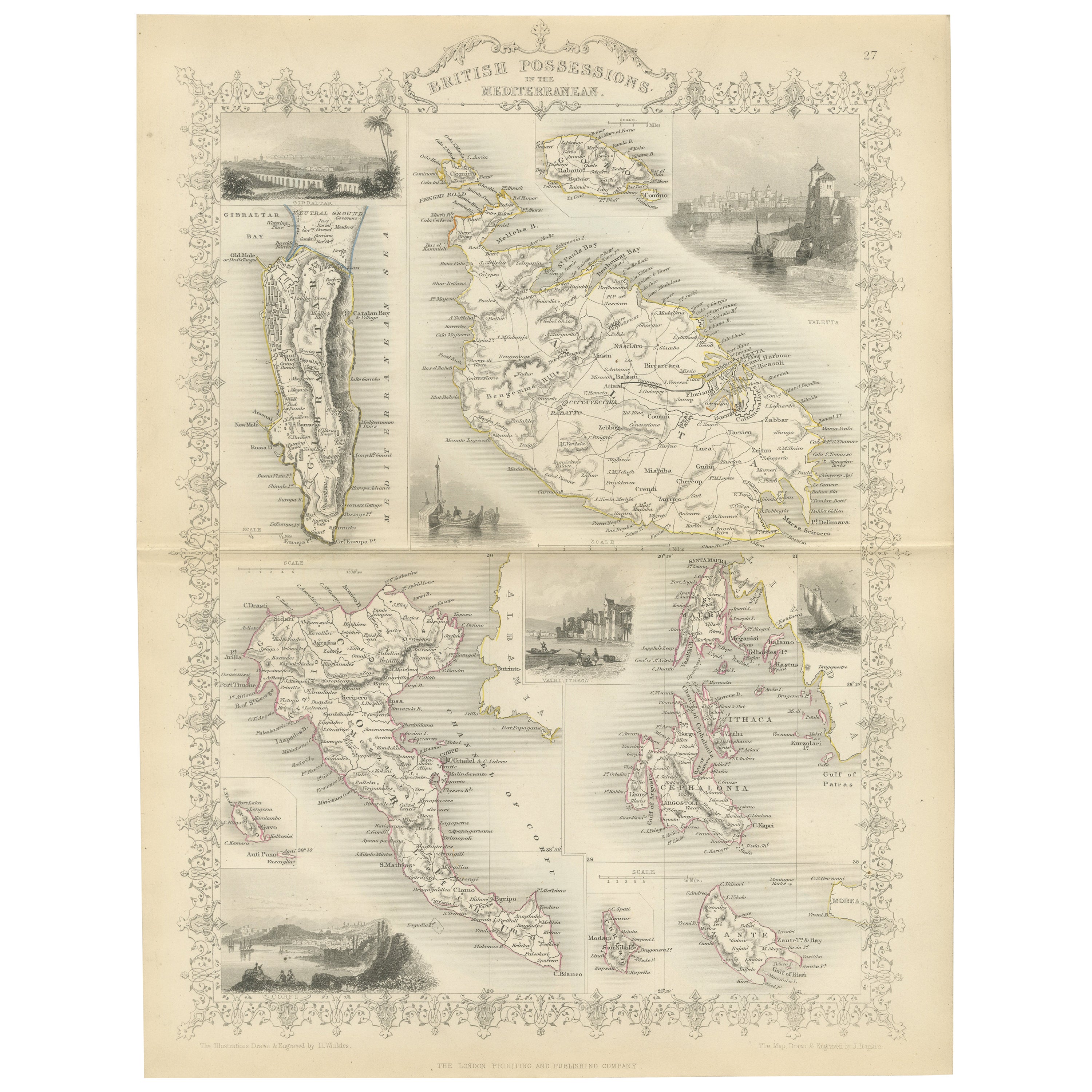
Old Map of British Mediterranean Territories with Images of Historic Sites, 1851
Located in Langweer, NL
John Tallis & Company was a British map-making firm that gained widespread acclaim in the 19th century, particularly known for their detailed and artistically embellished maps. The f...
Category
Antique 1850s Maps
Materials
Paper
$341 Sale Price
20% Off
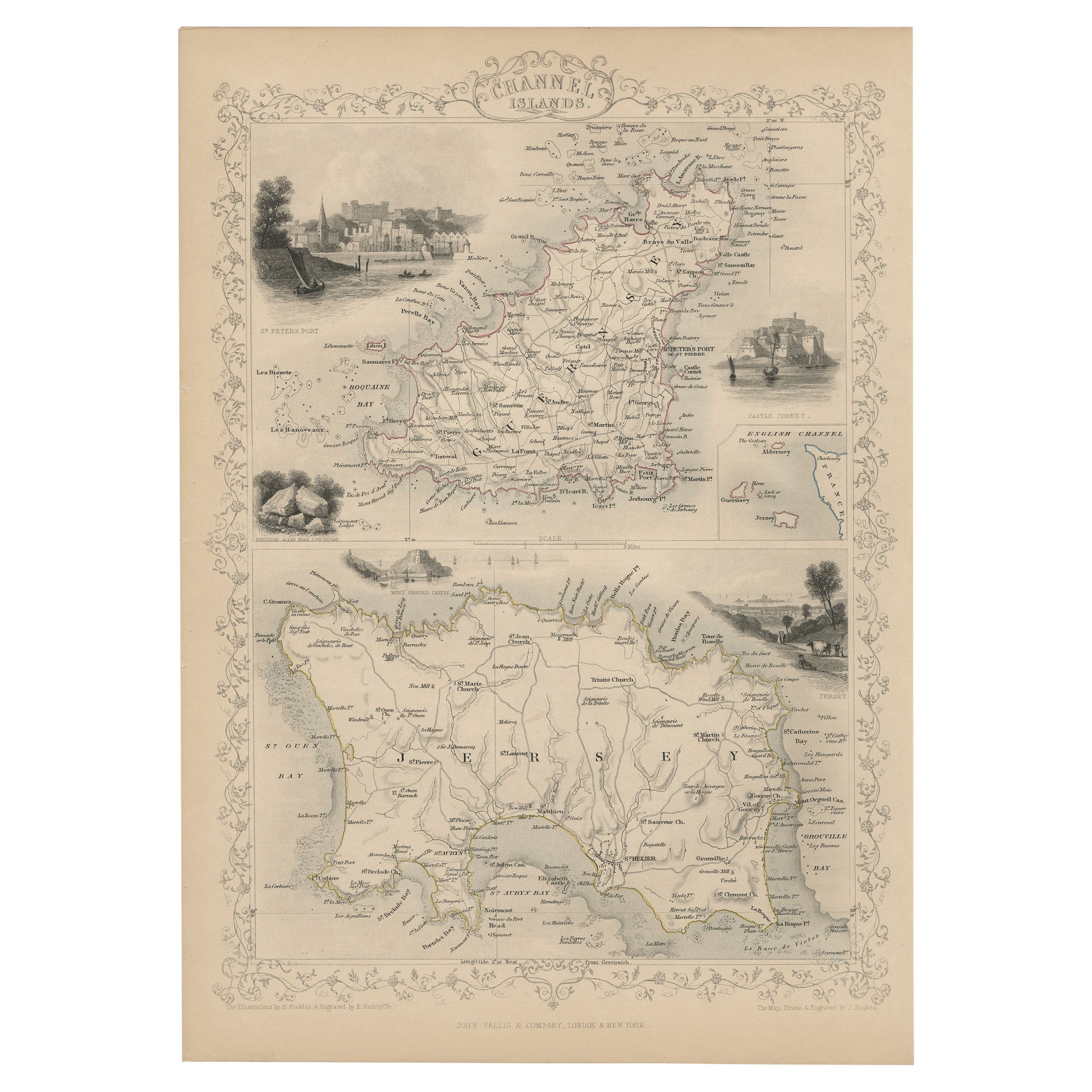
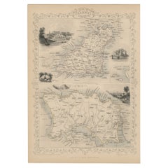
Original Antique Map of the Channel Islands, Incl. Decorative Vignettes, 1851
Located in Langweer, NL
Antique map titled ‘Channel Islands’.
Includes decorative vignettes titled St. Peters Port, Castle Cornet, Druidical altar near Lancresse, Mont Orgueil Castle and Jersey. Originates from 'The Illustrated Atlas, And Modern History Of The World Geographical, Political, Commercial & Statistical, Edited By R. Montgomery Martin'. Published; John Tallis London, New York, Edinburgh & Dublin. 1851. Drawn and Engraved by J. Rapkin.
Artists and engravers: John Tallis (1817-1876) was a British map...
Category
Antique 1850s Maps
Materials
Paper
$426 Sale Price
20% Off
Antique Map of Northern Africa by Perthes, 1848
Located in Langweer, NL
Antique map titled 'Africa Propria (..)'. Old map of North Africa and the region of Babylon originating from 'Orbis Terrarum Antiquus in usum Scholarum'. Artists and Engravers: Publi...
Category
Antique 19th Century Maps
Materials
Paper

$93 Sale Price
20% Off
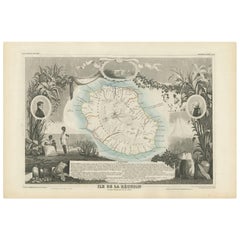
Antique Map of Bourbon/Reunion 'France' by V. Levasseur, 1854
By Victor Levasseur
Located in Langweer, NL
Antique map titled 'Ile de la Réunion'. Map of the French department of Ile. Bourbon or Reunion. Bourbon, or Reunion, is a volcanic island off the coast of Africa. It is one of Franc...
Category
Antique Mid-19th Century French Maps
Materials
Paper
$189 Sale Price
20% Off
More Ways To Browse
Paul Wood Etching
Pierre Bouillon
Prints From The Louvre
Queen Victoria Print
Racehorse Engraving
Tanzania Antique Map
Toulouse Lautrec Signed Lithograph
Turner Flamingo
Vertes Dancing
Vintage Air Race
Vintage Boardwalk
Vintage German Shepherd Prints
Weaver Bird Print
Wharton Esherick Print
18th Century Nautical Engraving
1950 Skira Ceramic Print
Abraham Lincoln Engraving
Acinonyx Jubatus