Items Similar to Beautiful Antique Map with Views of Dendermonde, Belgium, 1735

Want more images or videos?
Request additional images or videos from the seller
1 of 5
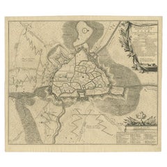
Beautiful Antique Map with Views of Dendermonde, Belgium, 1735
$623.35
$779.1920% Off
£463.06
£578.8320% Off
€520
€65020% Off
CA$865.59
CA$1,081.9920% Off
A$944.56
A$1,180.7020% Off
CHF 495.44
CHF 619.3020% Off
MX$11,472.04
MX$14,340.0420% Off
NOK 6,188.31
NOK 7,735.3920% Off
SEK 5,848.26
SEK 7,310.3320% Off
DKK 3,958.71
DKK 4,948.3820% Off
About the Item
Antique map titled 'Teneramonda vulgo Dendermonde'. Beautiful map with views of Dendermonde, Belgium. This map originates from 'Flandria illustrata, sive provinciae ac comitatus hujus descriptio'.
Artists and Engravers: Engraved by R. Blokhuyse. The author was Antonius Sanderus, who studied theology for some years under Malderus at Louvain, and Estius at Douai, and was ordained priest at Ghent.
Condition: Very good, please study image carefully.
Date: 1735
Overall size: 56 x 46 cm.
Image size: 51 x 41 cm.
We also offer thousands of antique prints covering fields of interest as diverse as architecture, natural history, religion, ethnology and many more. Antique prints have long been appreciated for both their aesthetic and investment value. They were the product of engraved, etched or lithographed plates. These plates were handmade out of wood or metal, which required an incredible level of skill, patience and craftsmanship. Whether you have a house with Victorian furniture or more contemporary decor an old engraving can enhance your living space.
- Dimensions:Height: 18.12 in (46 cm)Width: 22.05 in (56 cm)Depth: 0 in (0.01 mm)
- Materials and Techniques:
- Period:
- Date of Manufacture:1735
- Condition:
- Seller Location:Langweer, NL
- Reference Number:Seller: BGI-002231stDibs: LU3054326159272
About the Seller
5.0
Recognized Seller
These prestigious sellers are industry leaders and represent the highest echelon for item quality and design.
Platinum Seller
Premium sellers with a 4.7+ rating and 24-hour response times
Established in 2009
1stDibs seller since 2017
2,647 sales on 1stDibs
Typical response time: <1 hour
- ShippingRetrieving quote...Shipping from: Langweer, Netherlands
- Return Policy
Authenticity Guarantee
In the unlikely event there’s an issue with an item’s authenticity, contact us within 1 year for a full refund. DetailsMoney-Back Guarantee
If your item is not as described, is damaged in transit, or does not arrive, contact us within 7 days for a full refund. Details24-Hour Cancellation
You have a 24-hour grace period in which to reconsider your purchase, with no questions asked.Vetted Professional Sellers
Our world-class sellers must adhere to strict standards for service and quality, maintaining the integrity of our listings.Price-Match Guarantee
If you find that a seller listed the same item for a lower price elsewhere, we’ll match it.Trusted Global Delivery
Our best-in-class carrier network provides specialized shipping options worldwide, including custom delivery.More From This Seller
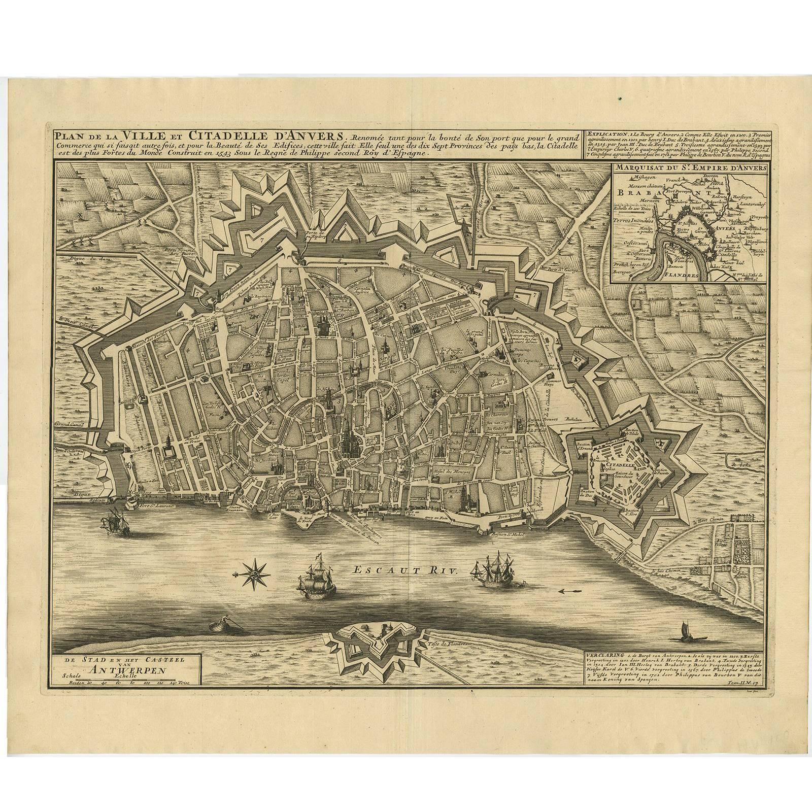
View AllAntique Map of the City of Antwerpen ‘Belgium’ by A. Deur, 1729
Located in Langweer, NL
Copper-engraving by A. Deur. Published by I. van der Kloot in Den Haag, 1729. With French and Dutch title-cartouches and explanatory notes, several ships o...
Category
Antique Early 18th Century Maps
Materials
Paper
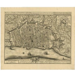
$738 Sale Price
20% Off
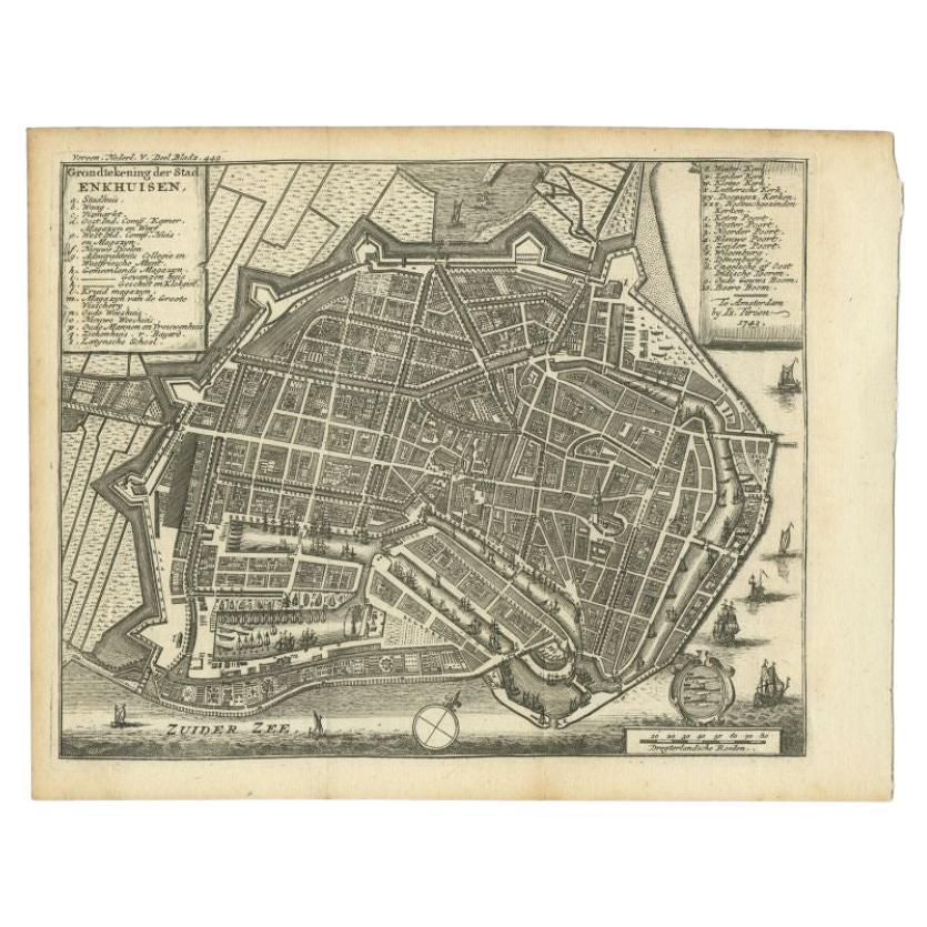
Antique Map of the City of Enkhuizen by Tirion, 1743
Located in Langweer, NL
Antique map titled ?Grondtekening der Stad Enkhuisen?. Beautiful map of the City of Enkhuizen. With Dutch legend. Decorated with compass rose, several ships and the city-arms. Artist...
Category
Antique 18th Century Maps
Materials
Paper
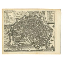
$143 Sale Price
20% Off
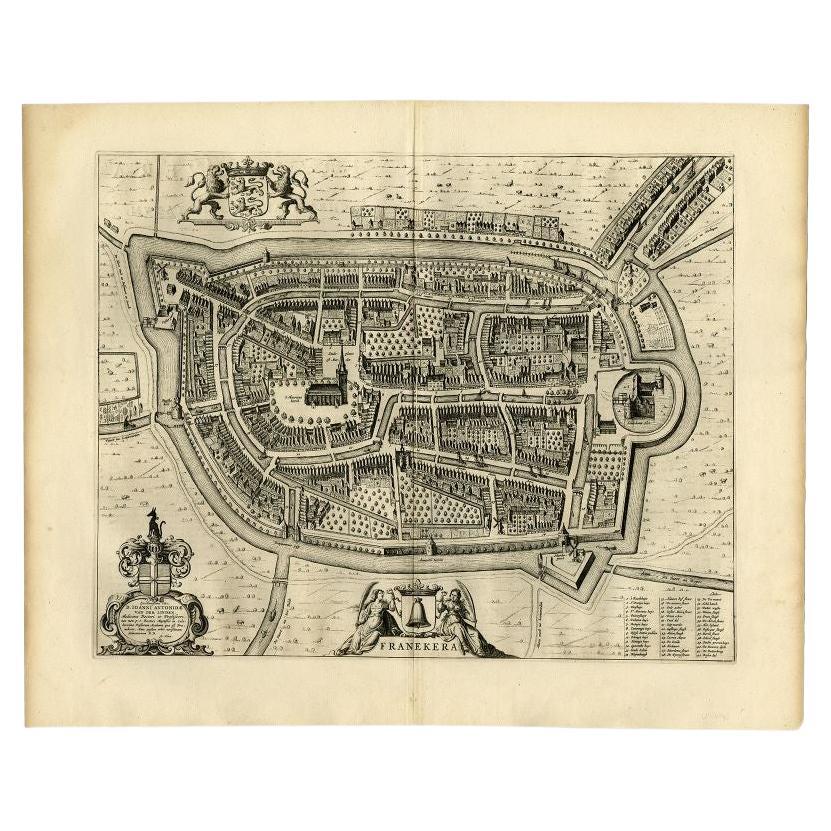
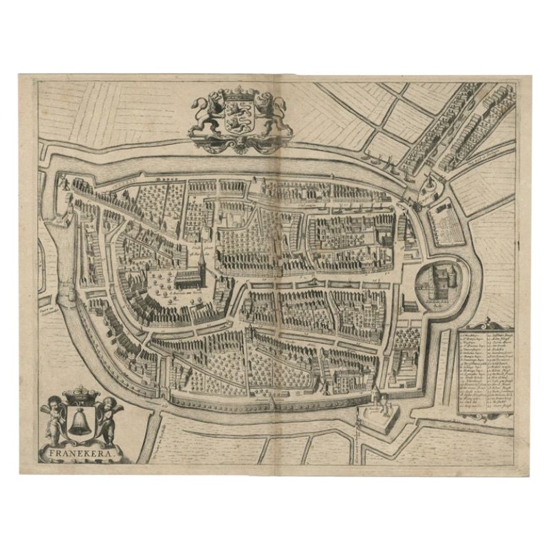
Antique Map of the City of Franeker by Blaeu, 1652
Located in Langweer, NL
Antique map titled 'Franekera'. Old map of the city of Franeker, Friesland. Also shows two cartouches, coats of arms and legend. This map originates from a Latin edition of the town ...
Category
Antique 17th Century Maps
Materials
Paper
$309 Sale Price
20% Off
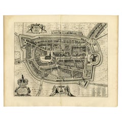
Antique Map of the City of Geldern by Blaeu, 1649
Located in Langweer, NL
Antique map titled 'Gelre'. Old map of the city of Geldern, Germany. This map originates from 'Toonneel der Steden van de Vereenighde Nederlanden' by J. Blaeu.
Artists and Engrav...
Category
Antique 17th Century Maps
Materials
Paper

$380 Sale Price
20% Off
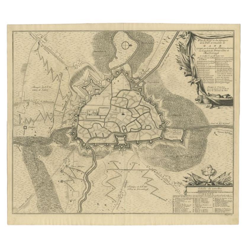
Antique Map of the Siege of Gent by Dumont, 1729
By Dumont
Located in Langweer, NL
Antique map titled 'Plan of the Siege and Attacks of the City and Citadel of Ghent'. Large map depicting the siege of the Belgian city of Gent in 1708 during the war of the Spanish S...
Category
Antique 18th Century Maps
Materials
Paper
$321 Sale Price
20% Off
Antique Map of the City of Franeker by Janssonius, 1657
By Johannes Janssonius
Located in Langweer, NL
Antique map titled ‘Franekera‘. This map depicts the city of Franeker (Friesland, The Netherlands). Published by J. Janssonius, Amsterdam, 1657.
Artists and Engravers: Johannes Jans...
Category
Antique 17th Century Maps
Materials
Paper
You May Also Like
Framed 1731 Color Engraving, Map of Rotterdam by Matthaus Seutter, "Roterodami"
Located in Bridgeport, CT
"Roterodami". Seutter (1678-1757) was an important German 18th century map maker. Bird's eye view of the city above with full details, neoclassi...
Category
Antique 18th Century European Renaissance Maps
Materials
Glass, Wood, Paper

18th Century Map Engraving - Newport, a Strong Sea-Port Town in Flanders
Located in Corsham, GB
A map of Nieuwpoort, anglicised to 'Newport', in northern Belgium. There is a panorama in the upper quarter depicting major landmarks. Below is a plan of the town, including its strong defences and ships at the port in the lower register. Inscribed with the title in plate to the lower edge, 'Newport a Strong Sea-Port Town...
Category
18th Century More Prints
Materials
Engraving

$269 Sale Price
20% Off
17th Century Toulouse, Savve, Sommieres Topographical Map by Iohan Peeters
Located in New York, NY
Fine topographical 17th century map of Toulouse, Savve and Sommieres by Iohan Peeters
Beautiful engraving of the capital of France's Occitanie Region, Toulouse, called La Ville Rose- the Pink City, for the terracotta bricks used in its many buildings, giving the city a distinct apricot-rose hue. An important cultural and educational center, the city's residents included Nobel Prize winners and world renown artists- Henri de Toulouse-Lautrec, Henri Martin, Jean-Auguste-Dominique Ingres, Antonin Mercie, Alexandre Falguiere and more recently Cyril Kongo...
Category
Antique 17th Century Dutch Maps
Materials
Paper

Map of Antwerp - Etching by G.Braun and F. Hogenberg -Late 16th century
By Franz Hogenberg
Located in Roma, IT
This Map of Anverpia is an original etching hand colored realized by George Braun and Franz Hogenberg as part of the famous Atlas "Civitates Orbis Ter...
Category
16th Century Old Masters Figurative Prints
Materials
Etching

17th Century Topographical Engraving Nantes & St. Malo, France, by Iohan Peeters
Located in New York, NY
The ancient city of Saint Malo in North Western France has long been associated with adventure on the high seas, piracy and exploration. It was the birthplace of several important in...
Category
Antique 17th Century Dutch Maps
Materials
Paper

1752 Vaugoundy Map of Flanders : Belgium, France, and the Netherlands, Ric.a002
Located in Norton, MA
Large Vaugoundy Map of Flanders:
Belgium, France, and the Netherlands
Colored -1752
Ric.a002
Description: This is a 1752 Didier Robert de Vaugondy map of Flanders. The map de...
Category
Antique 17th Century Unknown Maps
Materials
Paper

More Ways To Browse
Antique Painting Pompeii
Arman Boom Boom
Audubon Havell Edition
Audubon Havell
Aurelia In A Red Bonnet
Avi Kiriaty
Bernard Munch
Bjorn Wiinblad Lithograph
Botero Hand Signed
Calder Artist Proof
Carol Summers Vintage Prints
Chagall Circus Signed
Charles Cobelle Signed Lithograph
Charles T Bowling
Christian Choisy
Clyde Connell
Cobelle Lithograph
Cracked Gesso