Items Similar to Cemetery on Amsterdam Island, French Territory in the Indian Ocean, ca.1785


Want more images or videos?
Request additional images or videos from the seller
1 of 5
Cemetery on Amsterdam Island, French Territory in the Indian Ocean, ca.1785
About the Item
Antique print titled 'Begraafplaats op het eiland Amsterdam'.
Engraved view of a local cemetery on Amsterdam Island, a small French territory in the southern Indian Ocean. Originates from 'Reizen Rondom de Waereld door James Cook (..)'.
Artists and Engravers: Captain James Cook (1728 - 1779) was a British explorer, navigator, cartographer, and captain in the Royal Navy. Cook made detailed maps of Newfoundland prior to making three voyages to the Pacific Ocean, during which he achieved the first recorded European contact with the eastern coastline of Australia and the Hawaiian Islands, and the first recorded circumnavigation of New Zealand.
Condition: Fair/good, general age-related toning. Original foldin lines, with a few small repairs. Blank verso, please study image carefully.
- Dimensions:Height: 9.85 in (25 cm)Width: 15.36 in (39 cm)Depth: 0 in (0.02 mm)
- Materials and Techniques:
- Period:1780-1789
- Date of Manufacture:circa 1785
- Condition:Repaired: Condition: Fair/good, general age-related toning. Original foldin lines, with a few small repairs. Blank verso, please study image carefully.
- Seller Location:Langweer, NL
- Reference Number:
About the Seller
5.0
Platinum Seller
These expertly vetted sellers are 1stDibs' most experienced sellers and are rated highest by our customers.
Established in 2009
1stDibs seller since 2017
1,929 sales on 1stDibs
Typical response time: <1 hour
- ShippingRetrieving quote...Ships From: Langweer, Netherlands
- Return PolicyA return for this item may be initiated within 14 days of delivery.
More From This SellerView All
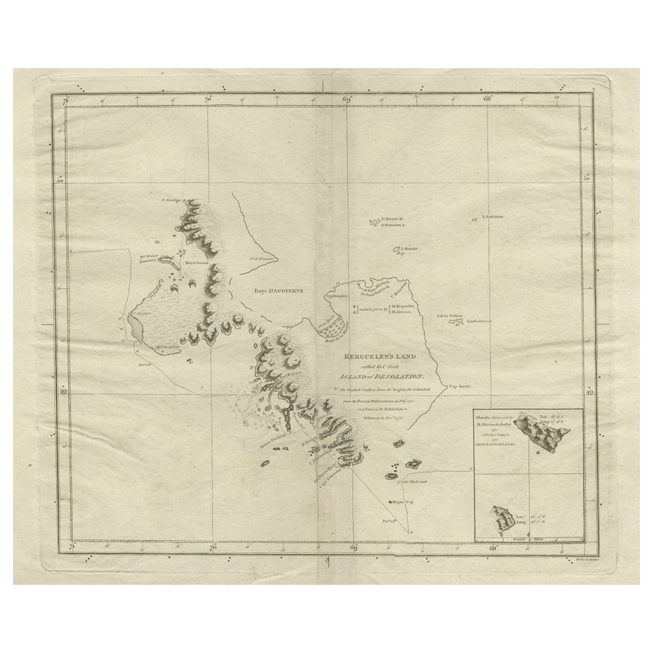
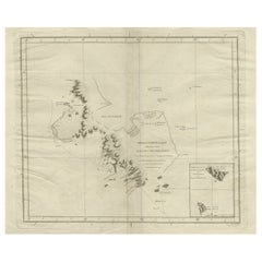
- Antique Map of Kerguelens Island Coast in the Indian Ocean by Cook, 1785By James CookLocated in Langweer, NLAntique print titled 'Kerguelen's Land (..)'. Antique map of Kerguelens island coast, known today as the Desolation islands. Originates from 'Voyage to the Pacific Ocean, undertaken ...Category
Antique 18th Century Prints
MaterialsPaper
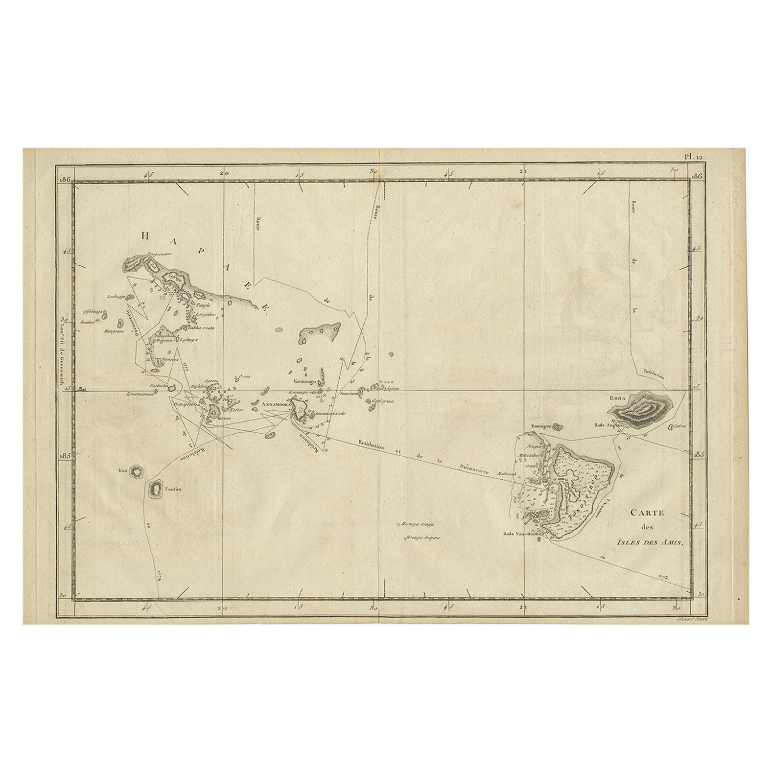
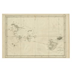
- Antique Engraved Map of the Friendly Islands or Tonga, ca.1785Located in Langweer, NLAntique map titled 'Carte des Isles des Amis'. Map of the Friendly Islands / Tonga. The Tongan people first encountered Europeans in 1616 when the Dutch vessel Eendracht, captain...Category
Antique 1780s Maps
MaterialsPaper
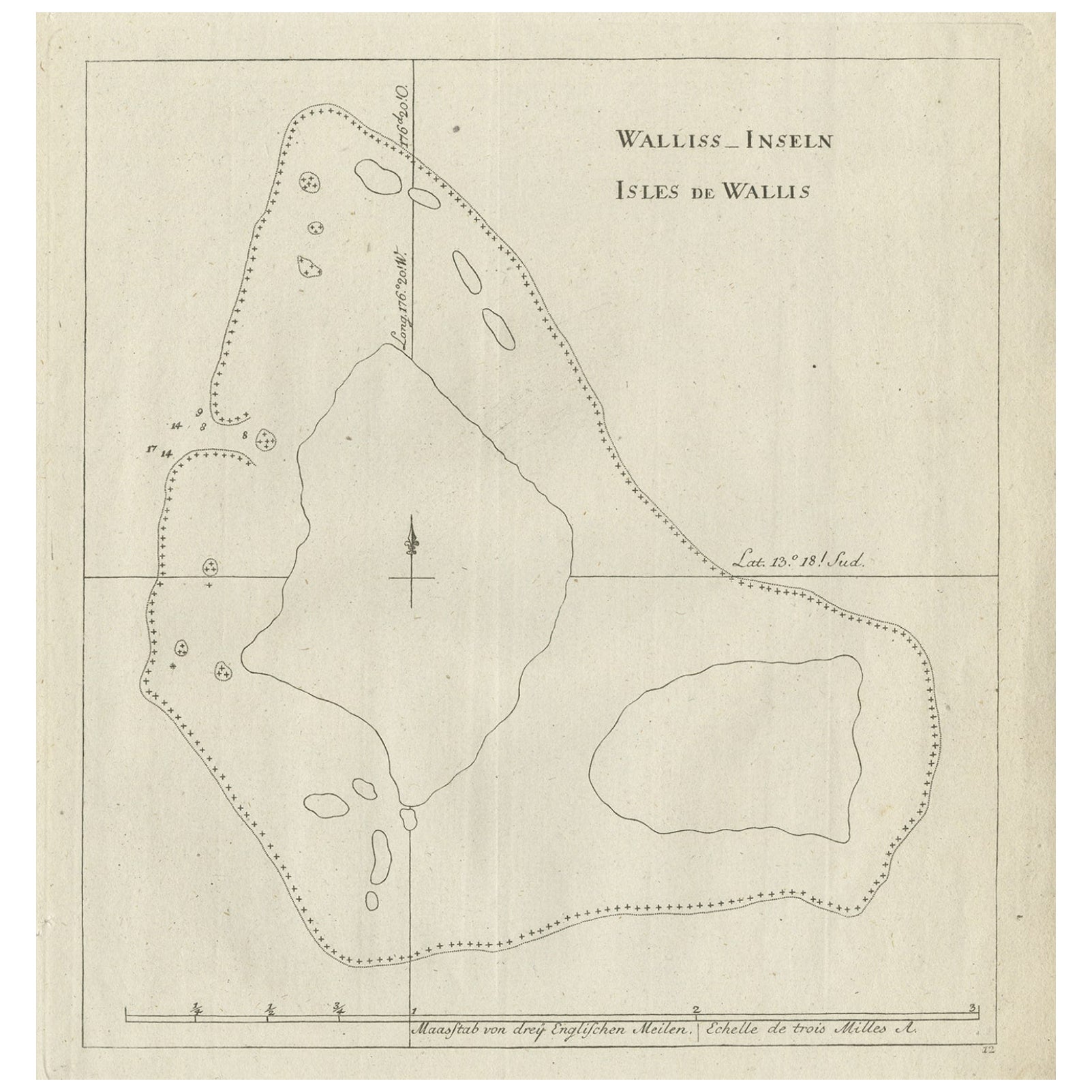
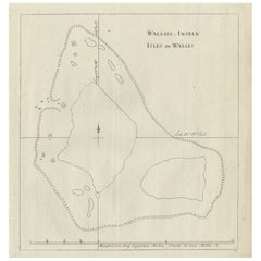
- Antique Map of the Wallis and Futuna Islands, French Overseas Territory, 1778Located in Langweer, NLAntique map titled 'Walliss Inseln, Isles de Wallis'. Old map of the Wallis and Futuna Islands, officially Territory of the Wallis and Futuna Islands, French overseas territory. The ...Category
Antique 18th Century Maps
MaterialsPaper
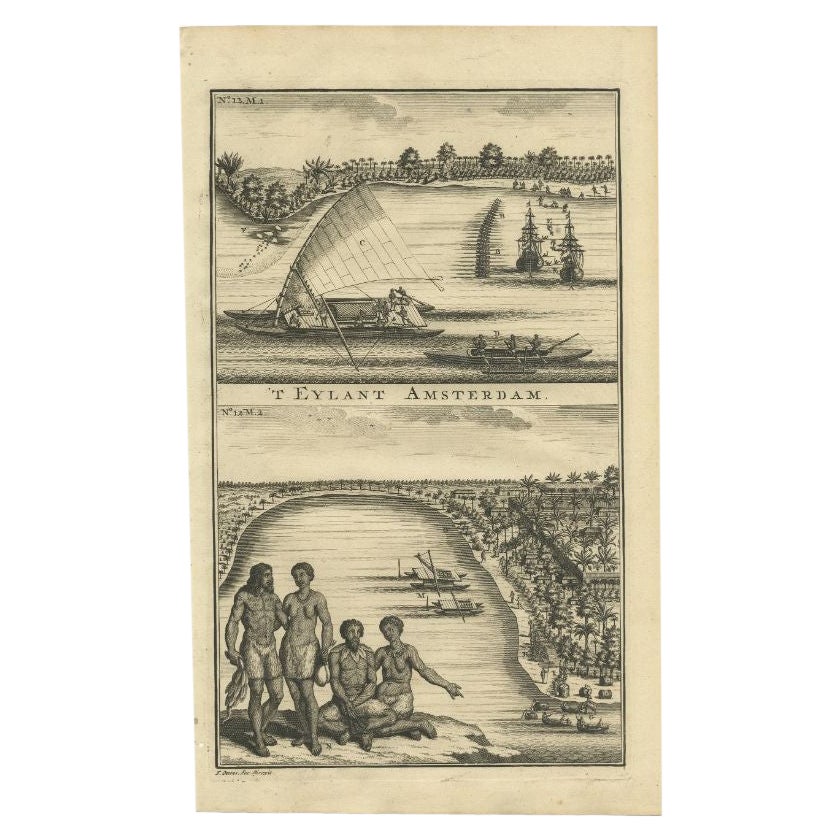
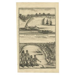
- Antique Print of Amsterdam Island in the Indian Ocean by Valentijn, 1726Located in Langweer, NLAntique print Indonesia titled 'T Eylant Amsterdam'. Two engravings on one sheet showing the native boats and peoples of Amsterdam Island in the Indian Ocean. Dutch (V.O.C.) sailing ...Category
Antique 18th Century Prints
MaterialsPaper
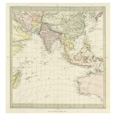
- Antique Map of Southern Asia, the East Indies and the Indian Ocean, ca.1840Located in Langweer, NLOriginal antique map of Southern Asia, the East Indies and the Indian Ocean. Also shows part of Australia. Published circa 1840. Artists and Engravers: ...Category
Antique 1840s Maps
MaterialsPaper
- Antique Map of the Islands in the Pacific Ocean by Wyld, '1845'Located in Langweer, NLAntique map titled 'Islands in the Pacific Ocean'. Original antique map of the islands in the Pacific Ocean. This map originates from 'An Atlas of the World, Comprehending Separate M...Category
Antique Mid-19th Century Maps
MaterialsPaper

You May Also Like
- Lithographic print on paper, depicting the atlas of the hand, France 1850 ca.Located in Milan, ITAn anatomical lithographic print on paper, depicting the anatomical atlas of the hand. Black lacquered fir wood frame with golden ramin wood batting. N. H. Ja...Category
Antique Mid-19th Century French Prints
MaterialsGlass, Wood, Paper
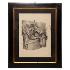
- Lithographic Print on Paper, Depicting the Male Genital System, France 1850 CaLocated in Milan, ITAn anatomical lithographic print on paper, depicting the male genital system. Black lacquered fir wood frame with golden ramin wood batting. N. H. Jacob, Pari...Category
Antique Mid-19th Century French Prints
MaterialsGlass, Wood, Paper
- Hand-Colored 18th Century Homann Map of Denmark and Islands in the Baltic SeaBy Johann Baptist HomannLocated in Alamo, CAAn 18th century copper plate hand-colored map entitled "Insulae Danicae in Mari Balthico Sitae utpote Zeelandia, Fionia, Langelandia, Lalandia, Falstria, Fembria Mona" created by Joh...Category
Antique Early 18th Century German Maps
MaterialsPaper
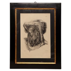
- Lithographic print on paper depicting the muscular system of a neck, France 1850Located in Milan, ITAn anatomical lithographic print on paper, depicting a cross section of the muscular system of the neck. Black lacquered fir wood frame with golden ramin wood batting...Category
Antique Mid-19th Century French Prints
MaterialsGlass, Wood, Paper
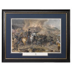
- "On the March to the Sea" Print by Alexander Hay Ritchie, after F.O.C DarleyBy Alexander Hay RitchieLocated in Colorado Springs, COThis color print of On The March to the Sea by Felix O.C. Darley, and engraved by A.H. Ritchie, is a stunning portrayal of William T. Sherman’s notorious Georgia Campaign. Originally...Category
Antique 1860s American Prints
MaterialsPaper


Recently Viewed
View AllMore Ways To Browse
Antique Indian Door
Antique Indian Doors
Indian Antique Door
Indian Antique Doors
British Royal Navy
Hawaiian Antique
Antique Hawaiian
Map Of Southern Europe
Royal Hawaiian
Antique Furniture Hawaii
Antique Hawaiian Furniture
Hawaiian Antique Furniture
Antique Newfoundland
Pacific Ocean Antique Map
Antique New Zealand Map
Antique Maps New Zealand
New Zealand Antique Map
Antique Map Of New Zealand