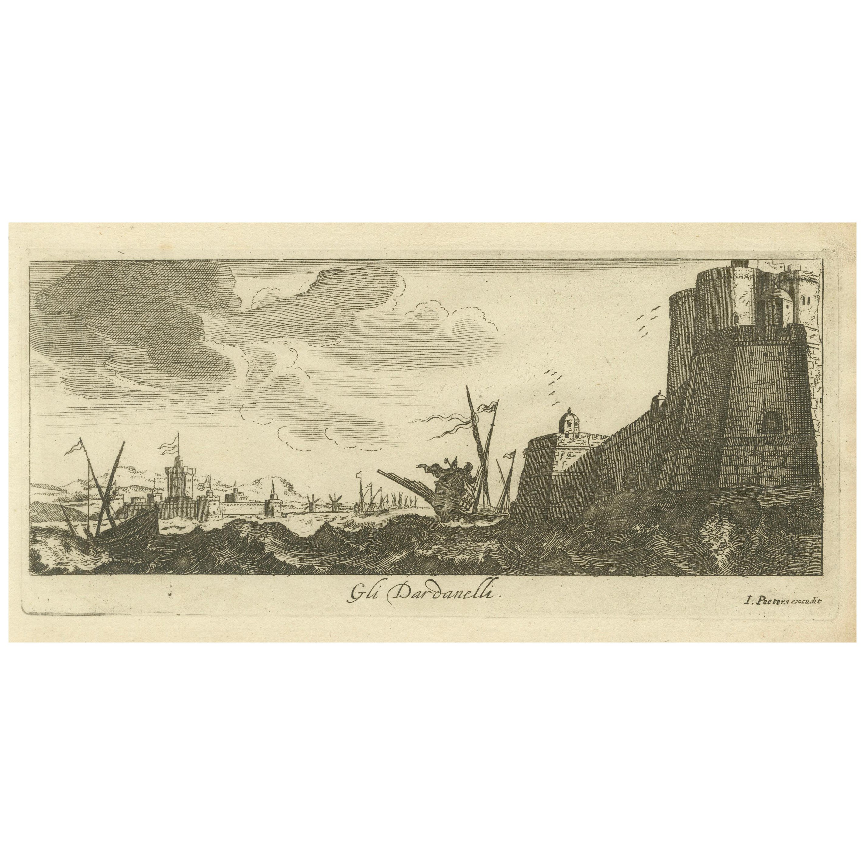
Items Similar to Engraved View of the Dardanelles with Fortifications and Ships, ca. 1680
Want more images or videos?
Request additional images or videos from the seller
1 of 6
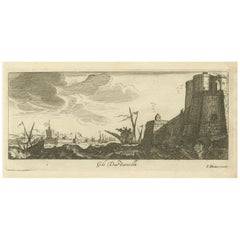
Engraved View of the Dardanelles with Fortifications and Ships, ca. 1680
$260.83
£195.20
€220
CA$359.84
A$400.16
CHF 210.17
MX$4,892.31
NOK 2,618.93
SEK 2,468.94
DKK 1,674.75
About the Item
Title: View of the Dardanelles with Fortifications and Ships, ca. 1680
Description: This copperplate engraving offers a detailed view of the Dardanelles Strait, emphasizing its strategic importance with prominent fortifications along the shoreline. The foreground showcases a circular tower with cannons, flying a crescent-flag, while ships navigate the turbulent waters under the watch of soldiers. In the background, additional fortifications and structures are visible, further highlighting the significance of this maritime passage. Attributed to Jan Peeters as the delineator and published by Jacob Peeters, this engraving reflects the critical role of the Dardanelles in 17th-century navigation and defense.
Condition:
Good condition with strong impressions and clear details. Light foxing is visible, especially in the margins, with minor handling marks. Slight edge wear but does not detract from the overall visual appeal.
- Dimensions:Height: 6.7 in (17 cm)Width: 11.23 in (28.5 cm)Depth: 0.01 in (0.2 mm)
- Materials and Techniques:Paper,Engraved
- Period:1680-1689
- Date of Manufacture:circa 1680
- Condition:Good condition with strong details, light foxing, minor handling marks, slight edge wear, due to age and handling.
- Seller Location:Langweer, NL
- Reference Number:Seller: BG-14036-91stDibs: LU3054342967732
About the Seller
5.0
Recognized Seller
These prestigious sellers are industry leaders and represent the highest echelon for item quality and design.
Platinum Seller
Premium sellers with a 4.7+ rating and 24-hour response times
Established in 2009
1stDibs seller since 2017
2,607 sales on 1stDibs
Typical response time: <1 hour
- ShippingRetrieving quote...Shipping from: Langweer, Netherlands
- Return Policy
Authenticity Guarantee
In the unlikely event there’s an issue with an item’s authenticity, contact us within 1 year for a full refund. DetailsMoney-Back Guarantee
If your item is not as described, is damaged in transit, or does not arrive, contact us within 7 days for a full refund. Details24-Hour Cancellation
You have a 24-hour grace period in which to reconsider your purchase, with no questions asked.Vetted Professional Sellers
Our world-class sellers must adhere to strict standards for service and quality, maintaining the integrity of our listings.Price-Match Guarantee
If you find that a seller listed the same item for a lower price elsewhere, we’ll match it.Trusted Global Delivery
Our best-in-class carrier network provides specialized shipping options worldwide, including custom delivery.More From This Seller
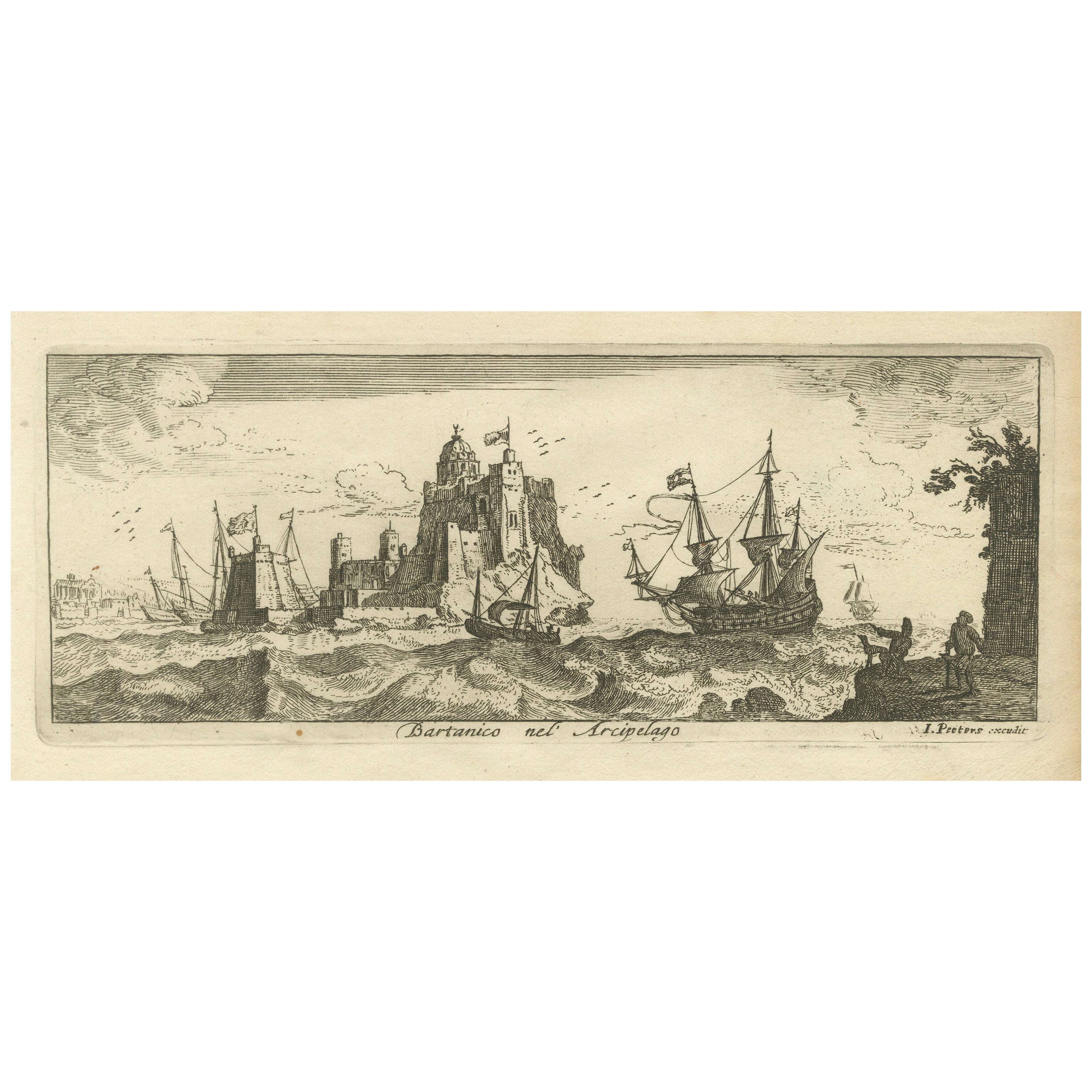
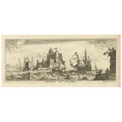
View AllView of Bartanico in the Aegean Archipelago with Fortifications and Ships, 1680
Located in Langweer, NL
Title: View of Bartanico in the Aegean Archipelago with Fortifications and Ships, ca. 1680
Description: This copperplate engraving depicts a striking view of Bartanico (possibly P...
Category
Antique 1680s Prints
Materials
Paper
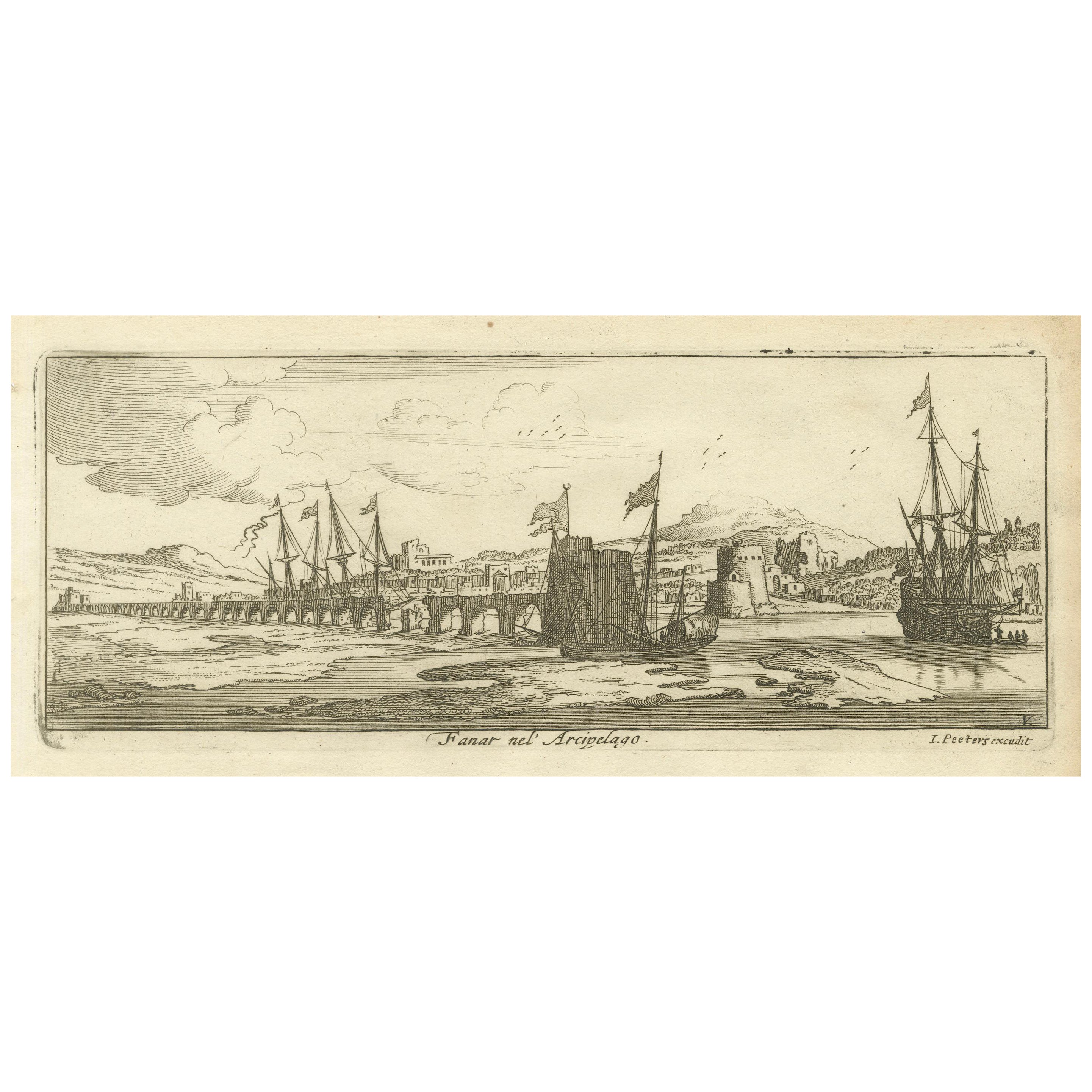
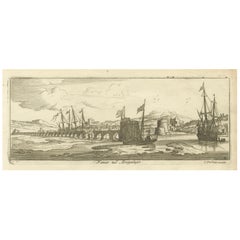
View of Fanar in the Aegean Archipelago with Bridge and Ships, ca. 1680
Located in Langweer, NL
Title: View of Fanar in the Aegean Archipelago with Bridge and Ships, ca. 1680
Description: This copperplate engraving showcases a detailed view of Fanar (possibly Fener or anothe...
Category
Antique 1680s Prints
Materials
Paper
The Dardanelles with Fortified Towers and Maritime Activity, ca. 1680
Located in Langweer, NL
Title: The Dardanelles with Fortified Towers and Maritime Activity, ca. 1680
Description: This copperplate engraving portrays the Dardanelles Strait with its imposing fortified to...
Category
Antique 1680s Prints
Materials
Paper
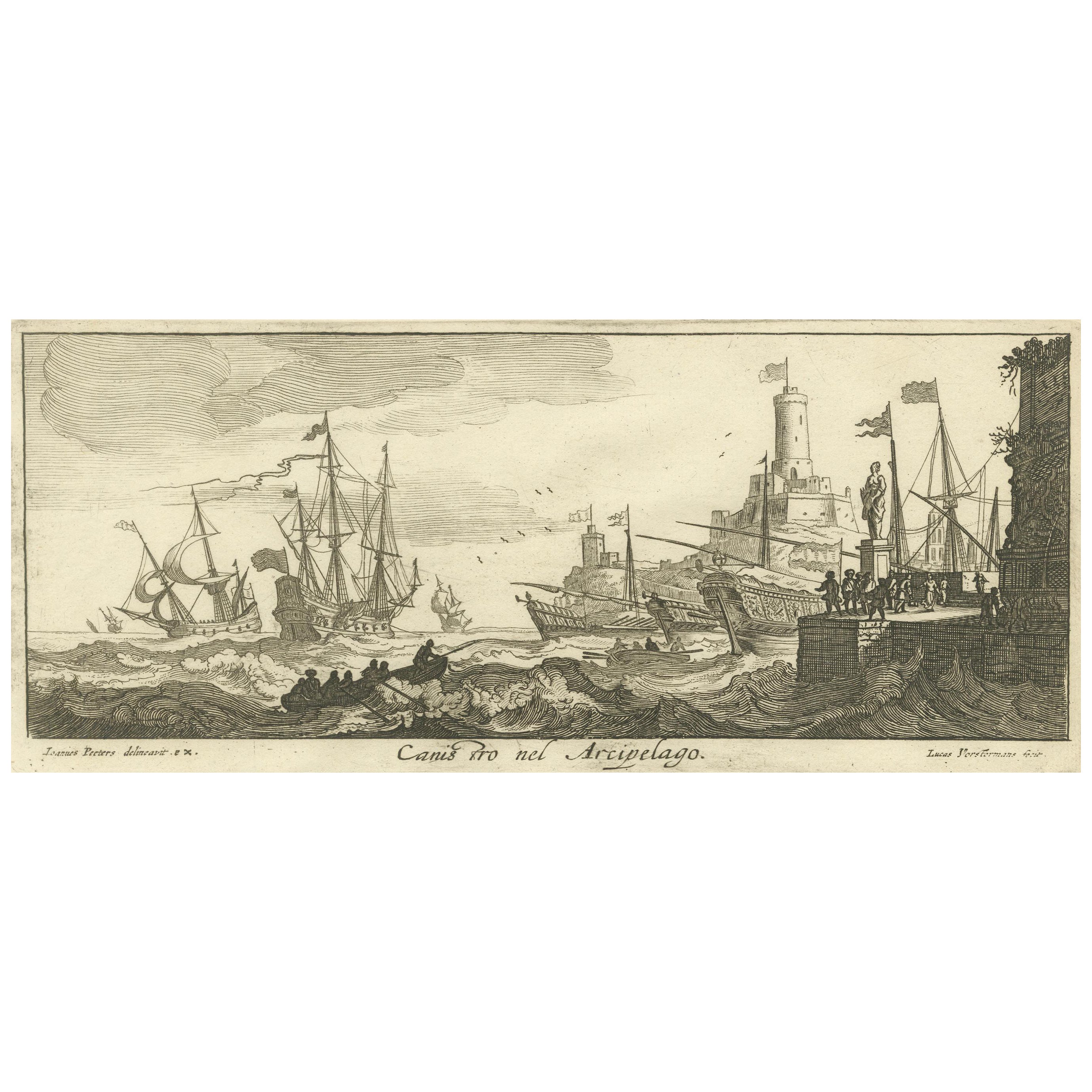
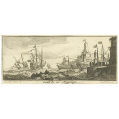
Maritime Scene in the Aegean Archipelago with Fortifications & Ships, circa 1680
Located in Langweer, NL
Title: Canal Scene in the Archipelago – Engraving by Lucas Vorsterman after Jan Peeters, Antwerp, circa 1680
Description: This copperplate engraving depicts a lively maritime sce...
Category
Antique 1680s Prints
Materials
Paper
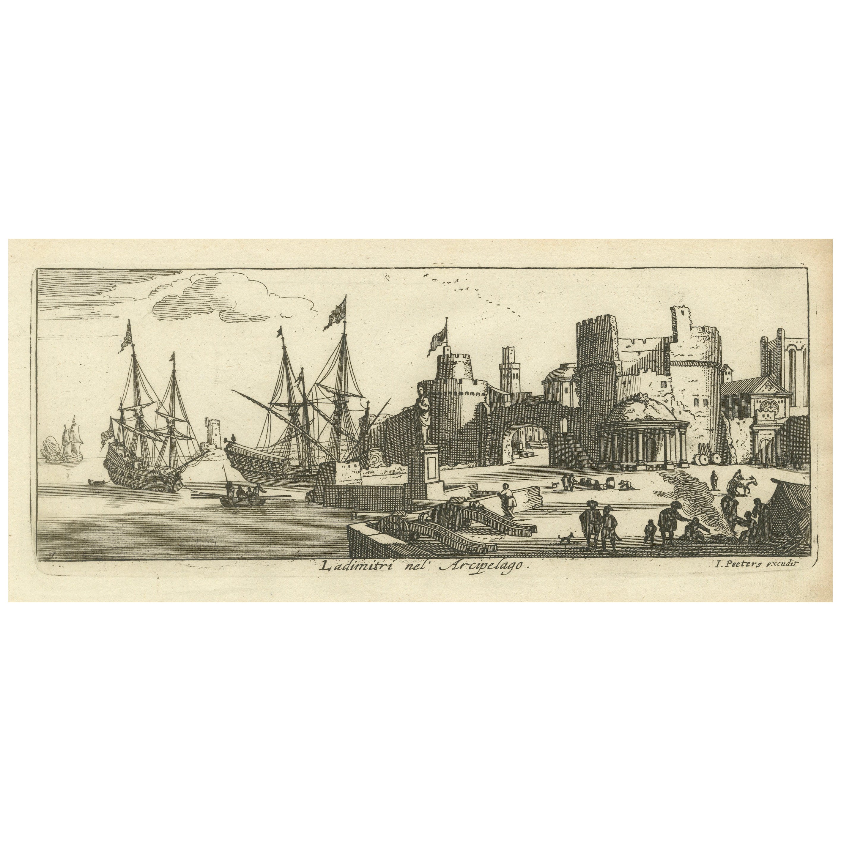
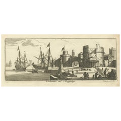
Port Scene at Ladimiti in the Aegean Archipelago with Fortifications, ca. 1680
Located in Langweer, NL
Title: Port Scene at Ladimiti in the Aegean Archipelago with Fortifications, ca. 1680
Description: This copperplate engraving depicts a bustling port scene at Ladimiti (likely Lem...
Category
Antique 1680s Prints
Materials
Paper
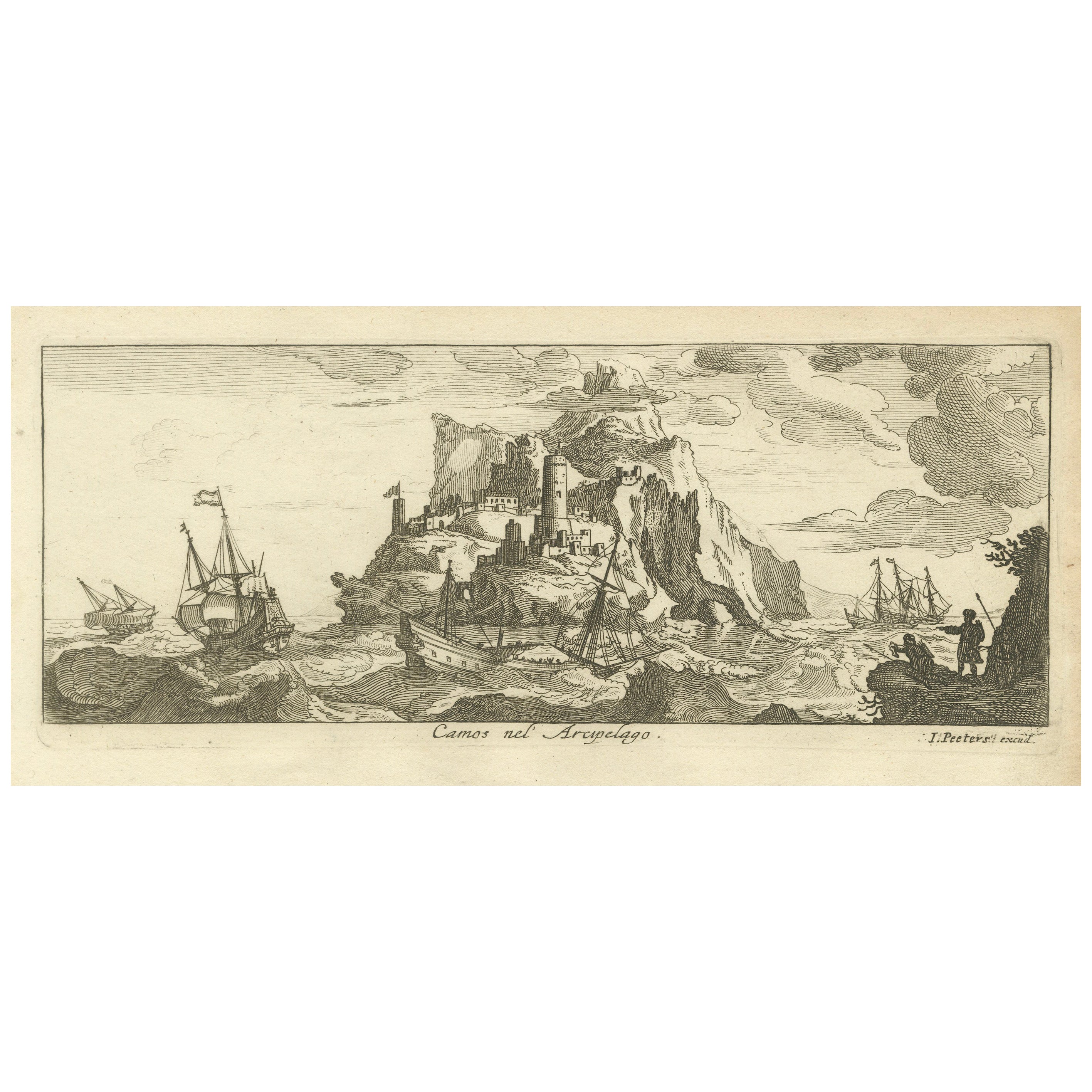
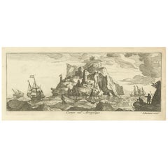
Fortified Island in the Aegean Archipelago with Ships at Sea, circa 1680
Located in Langweer, NL
Title: Fortified Island in the Aegean Archipelago with Ships at Sea, circa 1680
Description:
This copperplate engraving depicts a dramatic scene of a fortified island rising f...
Category
Antique 1680s Prints
Materials
Paper
You May Also Like
18th Century French Map and City View of Joppe/Jaffa (Tel Aviv) by Sanson
By Nicholas Sanson d'Abbeville
Located in Alamo, CA
An original antique engraving entitled "Joppe; in ’t Hebreeusch by ouds Japho; hedendaags Japha, of Jaffa; volgens d’aftekening gedaan 1668", by Nicholas Sanson d'Abbeville (1600 - 1667). This is a view of the city of Joppe (in Hebrew Japho), now called Japha or Jaffa, the harbor portion of modern day Tel Aviv, Israel as it appeared in 1668 . It depicts a very busy harbor with numerous boats. A large ship on the left appears to be firing its canons and a small ship on the right appears to be sitting very low in the water, either heavily loaded with cargo or sinking. The town is seen on the far shore with a fortress on a hill across in the background. The map is printed from the original Sanson copperplate and was published in 1709 by his descendants.
The map is presented in an ornate brown wood frame embellished by gold-colored leaves and gold inner trim with a double mat; the outer mat is cream-colored and the inner mat is black. There is a central vertical fold, as issued. There are two small spots in the lower margin and one in the upper margin, as well as two tiny spots adjacent to the central fold. 1717 is written below the date 1668 in the inscription. The map is otherwise in very good condition.
Another map of the "Holy Land" (by Claes Visscher in 1663), with an identical style frame and mat is available. This pair of maps would make a wonderful display grouping. Please see Reference #LU117324709892.
Artist: Nicholas Sanson d'Abbeville (1600 - 1667) and his descendents were important French cartographer's active through the 17th century. Sanson started his career as a historian and initially utilized cartography to illustrate his historical treatises. His maps came to the attention of Cardinal Richelieu and then King Louis XIII of France, who became a supporter and sponsor. He subsequently appointed Sanson 'Geographe Ordinaire du Roi' the official map maker to the king. Sanson not only created maps for the king, but advised him on geographical issues and curated his map collection...
Category
Early 1700s Prints and Multiples
Materials
Engraving

Ships - Etching by Charles-François Lacroix de Marseille - 18th Century
Located in Roma, IT
Ships is an etching realized by Charles-François Lacroix de Marseille in the 18th Century.
Good conditions with slight foxing.
The artwork is realized through deft expressive strokes.
Category
18th Century Modern Landscape Prints
Materials
Etching, Paper
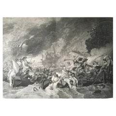
B.West Engraving "Naval Battle, Battle of the Houge" 18th Century
Located in Beuzevillette, FR
This magnificent engraving is entitled "Battle of La Hougue" by the engraver E.C Voysard after Benjamin West.
It depicts the Battle of Barfleur- La Hougue,...
Category
Antique 18th Century French Prints
Materials
Paper
Ancient View of La Valetta - Original Lithograph - Early-19th Century
Located in Roma, IT
La Valetta is an original modern artwork realized in Italy in the first half of the 19th Century.
Original Lithograph on Ivory Paper.
Inscripted in capital letters on the lower ma...
Category
1850s Modern Figurative Prints
Materials
Lithograph
Antique Voc Print Holland Malaysia Old Map Melaka History, 1663
Located in Amsterdam, Noord Holland
From my own collection I offer this impressive Antique print of the city of Malakka
A very interesting piece for collectors . It is an museum piece from the Dutch Institute of Orien...
Category
Antique 17th Century European Paintings
Materials
Paper

$293 Sale Price
20% Off
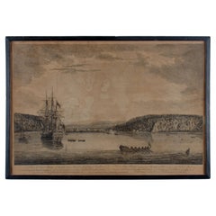
A View of Cape Rouge, Quebec, Canada, Mazell after Capt. Hervey Smyth, c.1760s
Located in Savannah, GA
A View of Cape Rouge, or Carouge, on the Saint Lawrence River, north of Quebec.
Engraving by Peter Mazell after a drawing by Captian Hervey Smyth, published c.1760's, London.
T...
Category
Antique 1760s Canadian British Colonial Prints
Materials
Paper
More Ways To Browse
Bronze Cupid And Psyche
Bronze Eagle Finial
Bronze Trinket Box
Brooklyn Navy Yard
Burl Wood China Cabinet
Carved Bone Tusks
Carved Jade Frame
Cast Iron Fish
Chest Of Drawers Blonde
Chinese Court Lady
Chinese Export Tea Cup
Chinese Kite
Chinese Wood Mask
Chippendale Block Front
Chrysanthemum Stone
Clockwork Toys
Congo Table
Connecticut Chest