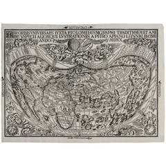
First World Map Available to the Collector to Bear the Name America
View Similar Items


1 of 1
First World Map Available to the Collector to Bear the Name America
About the Item
- Creator:Peter Apian (Illustrator)
- Dimensions:Height: 25 in (63.5 cm)Width: 29.5 in (74.93 cm)Depth: 2 in (5.08 cm)
- Style:Medieval (Of the Period)
- Place of Origin:
- Period:
- Date of Manufacture:1520
- Condition:Wear consistent with age and use. Condition report available upon request.
- Seller Location:Houston, TX
- Reference Number:1stDibs: LU129322126752
You May Also Like
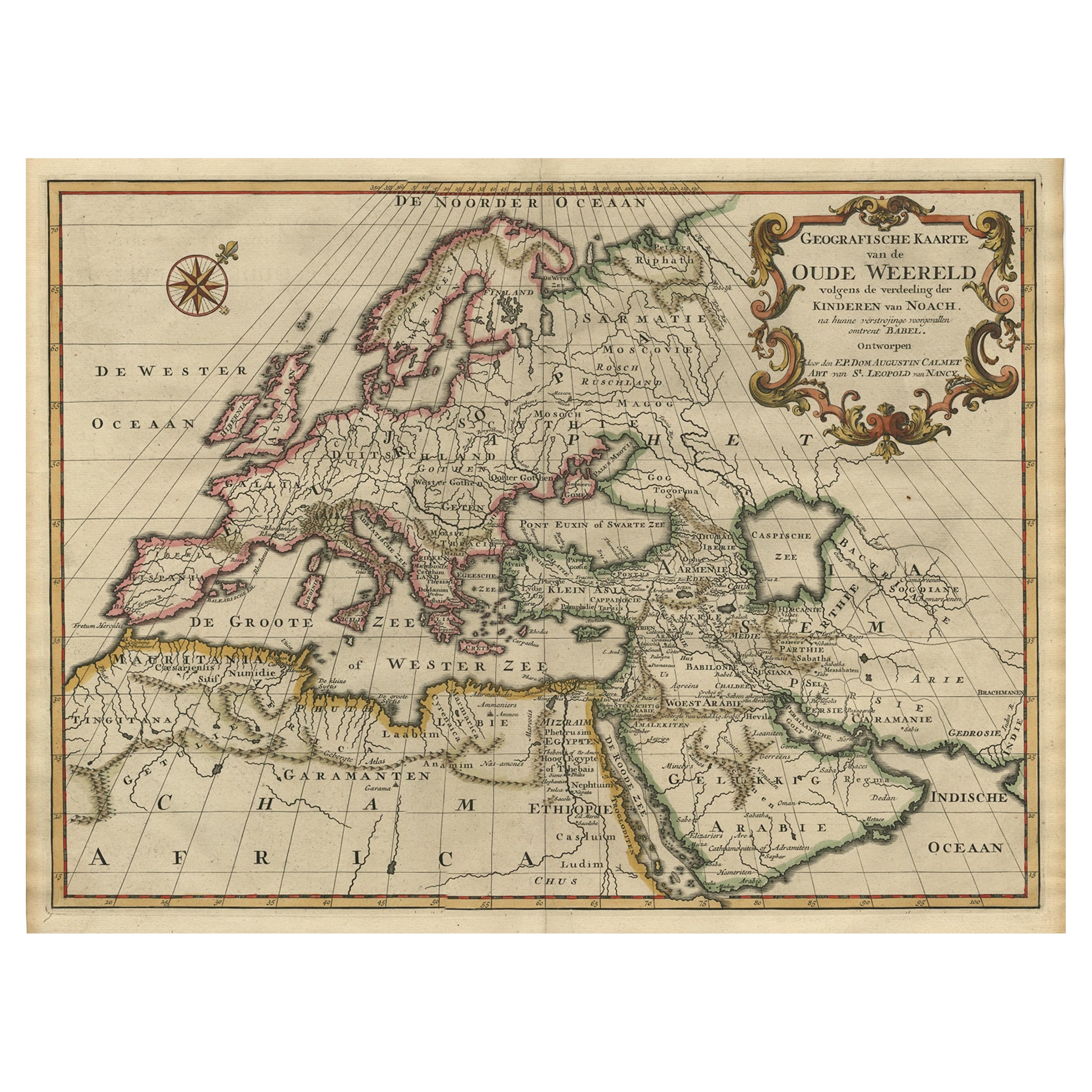
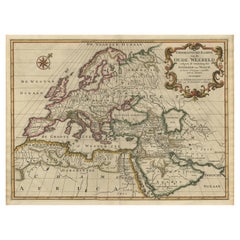
- Ancient World Map of Europe, Asia & Northern Africa with Ancient Names, 1725Located in Langweer, NLAntique map titled 'Geografische Kaarte van de Oude Weereld (..).' Original antique map of the ancient world depicting Europe, Asia, and northern Africa with ancient place names....Category
Antique 1720s Maps
MaterialsPaper
 $1,030 Sale Price24% Off
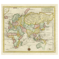
 - Antique Map of the Eastern Part of the WorldLocated in Langweer, NLAntique map titled 'Nieuwe Kaart van het Oostelykste Deel der Weereld, diendende tot aanwyzing van de Scheepstogten der Nederlanderen Naar Oostindie'. This finely engraved map of the...Category
Antique Mid-18th Century Maps
MaterialsPaper
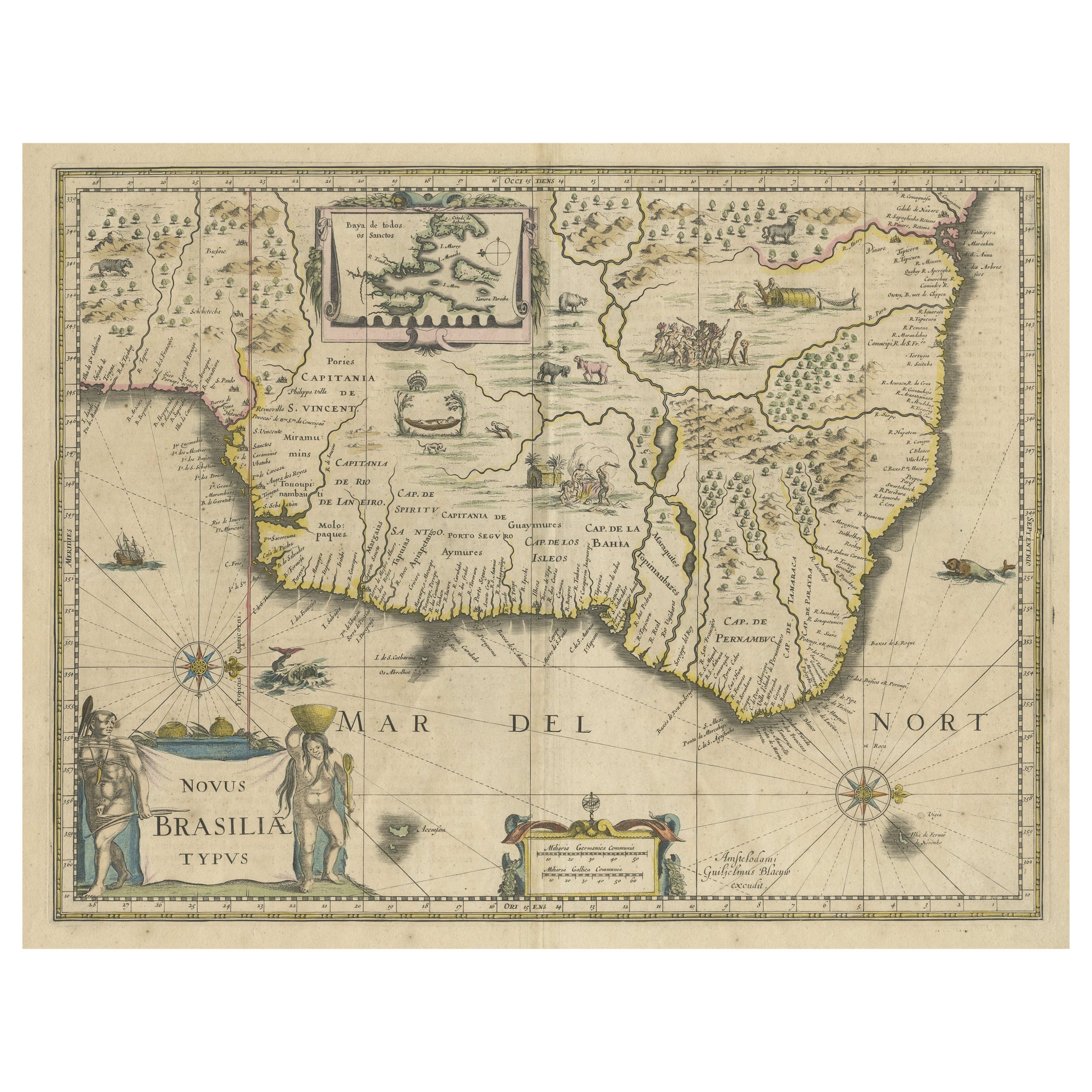
- Old Color Engraving of Blaeu's first Map of Brazil, North Oriented to the RightBy Willem BlaeuLocated in Langweer, NLAntique map titled 'Novus Brasiliae Typus'. Fine old color example of Blaeu's first map of Brazil, with north oriented to the right. Includes inset map of Baya de todos Santos, elaborate cartouche, 2 compass roses and richly embellished vignettes of native Brazilian life and animals. The interior of the map includes vignettes of indigenous animals and native scenes, including cannibalism. Inset within a decorative border is a small map of "Baya de todos Sanctos". In the sea are monsters, a galleon and two compass roses. The large title cartouche features a male and female Brazilian, both of whom are shown naked. Willem Janszoon Blaeu (1571-1638) was a prominent Dutch geographer and publisher. Born the son of a herring merchant, Blaeu chose not fish but mathematics and astronomy for his focus. He studied with the famous Danish astronomer Tycho Brahe...Category
Antique Mid-17th Century Maps
MaterialsPaper
- Antique Map of the World by Johnson, '1872'Located in Langweer, NLAntique map titled 'Johnson's World. Original world map. This map originates from 'Johnson's New Illustrated Family Atlas of the World' by A.J. John...Category
Antique Late 19th Century Maps
MaterialsPaper
 $411 Sale Price25% Off
 - Antique Map of the World by A. Vuillemin, 1854By Victor LevasseurLocated in Langweer, NLThis map originates from ‘Atlas National de la France Illustré’. Published by A. Combette, Paris, 1854.Category
Antique Mid-19th Century Maps
MaterialsPaper
 $308 Sale Price25% Off
 - Antique Map of the World by Balbi '1847'Located in Langweer, NLAntique map titled 'Planisphère'. Original antique map of the world. This map originates from 'Abrégé de Géographie (..)' by Adrien Balbi. Pub...Category
Antique Mid-19th Century Maps
MaterialsPaper
 $219 Sale Price20% Off
