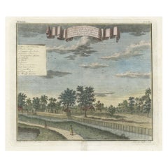
Items Similar to Old Antque Pirint of the New Dutch Church of Batavia 'Jakarta, Indonesia', 1744
Want more images or videos?
Request additional images or videos from the seller
1 of 6
Old Antque Pirint of the New Dutch Church of Batavia 'Jakarta, Indonesia', 1744
About the Item
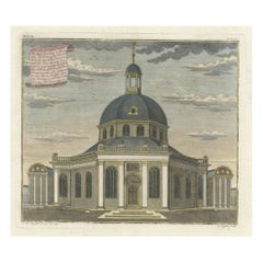
Antique print titled 'Ein Aufzug und Durchschnitt der Neuerbauten Holländischen Kirche in Batavia nach den Maastaab aufegzogen'.
Old print with a cross-section of the new Dutch church of Batavia (Jakarta). This print originates from from 'Allerneuester Geographische- und Topographischer Schau-platz, von Africa und Ost-Indien'.
Artists and engravers: Johann Wolfgang Heydt, a German artist who worked for the Dutch East India company.
- Dimensions:Height: 12.6 in (32 cm)Width: 14.57 in (37 cm)Depth: 0 in (0.02 mm)
- Materials and Techniques:
- Period:1740-1749
- Date of Manufacture:circa 1744
- Condition:Wear consistent with age and use. Condition: Fair, age-related toning. Few small repairs in image. Large damp stain left margin and a defect in the lower right margin, but all outside the image, leaving the print perfectly fine for framing. Please study image carefully.
- Seller Location:Langweer, NL
- Reference Number:
About the Seller
5.0
Platinum Seller
These expertly vetted sellers are 1stDibs' most experienced sellers and are rated highest by our customers.
Established in 2009
1stDibs seller since 2017
1,919 sales on 1stDibs
Typical response time: <1 hour
- ShippingRetrieving quote...Ships From: Langweer, Netherlands
- Return PolicyA return for this item may be initiated within 14 days of delivery.
More From This SellerView All
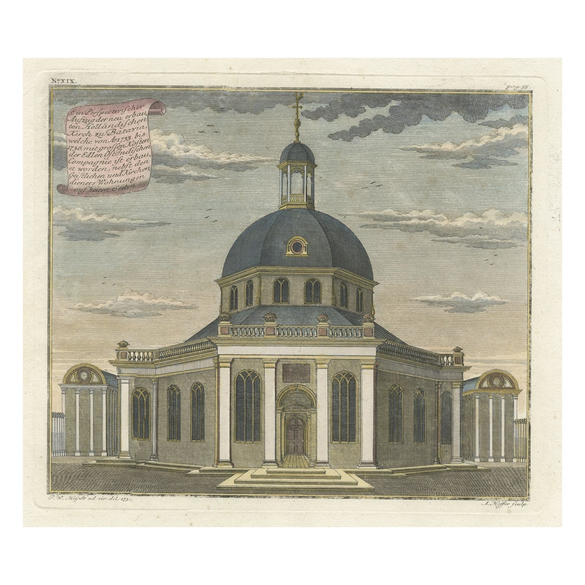
- Old Print with a View of the Dutch Church in Batavia 'Jakarta, Indonesia', 1738Located in Langweer, NLAntique print titled 'Ein Perspectivischer Aufzug der neu erbauten Holländischen Kirch zu Batavia, welche von Ao. 1733. bis 1736. mit grossen Kosten der Ed;en Ost-Indischen Compagnie...Category
Antique 1730s Maps
MaterialsPaper
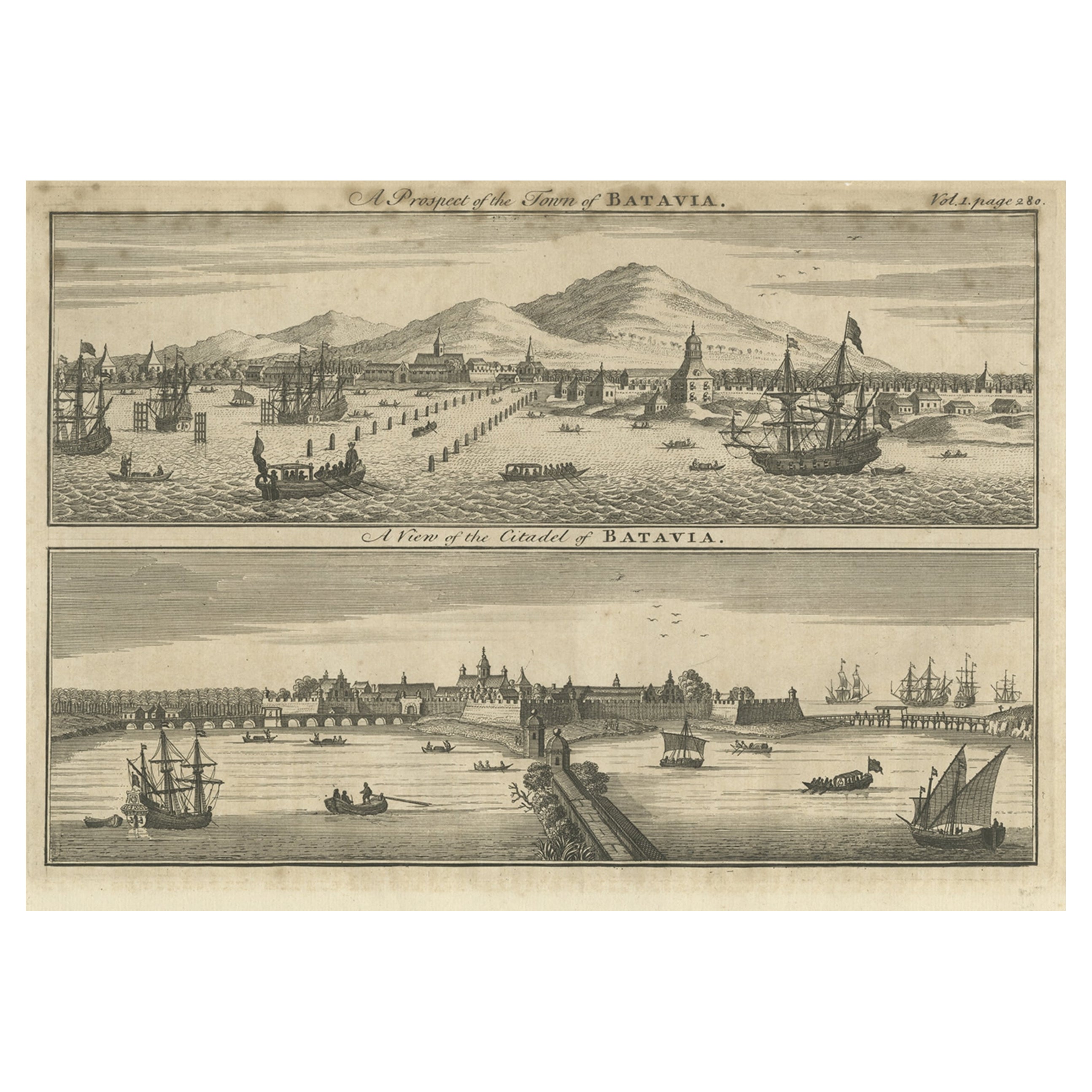
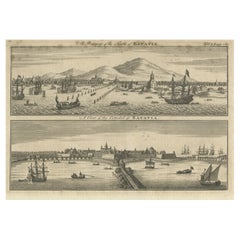
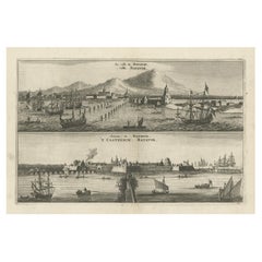
- Antique Print of Batavia 'Jakarta', in the Dutch East Indies, 1744Located in Langweer, NLTwo views on one plate titled 'A Prospect of The Town of Batavia (and) A View of the Citadel of Batavia'. Beautiful views of Batavia (Jakarta), Indonesia. The upper view shows the ci...Category
Antique 18th Century Prints
MaterialsPaper
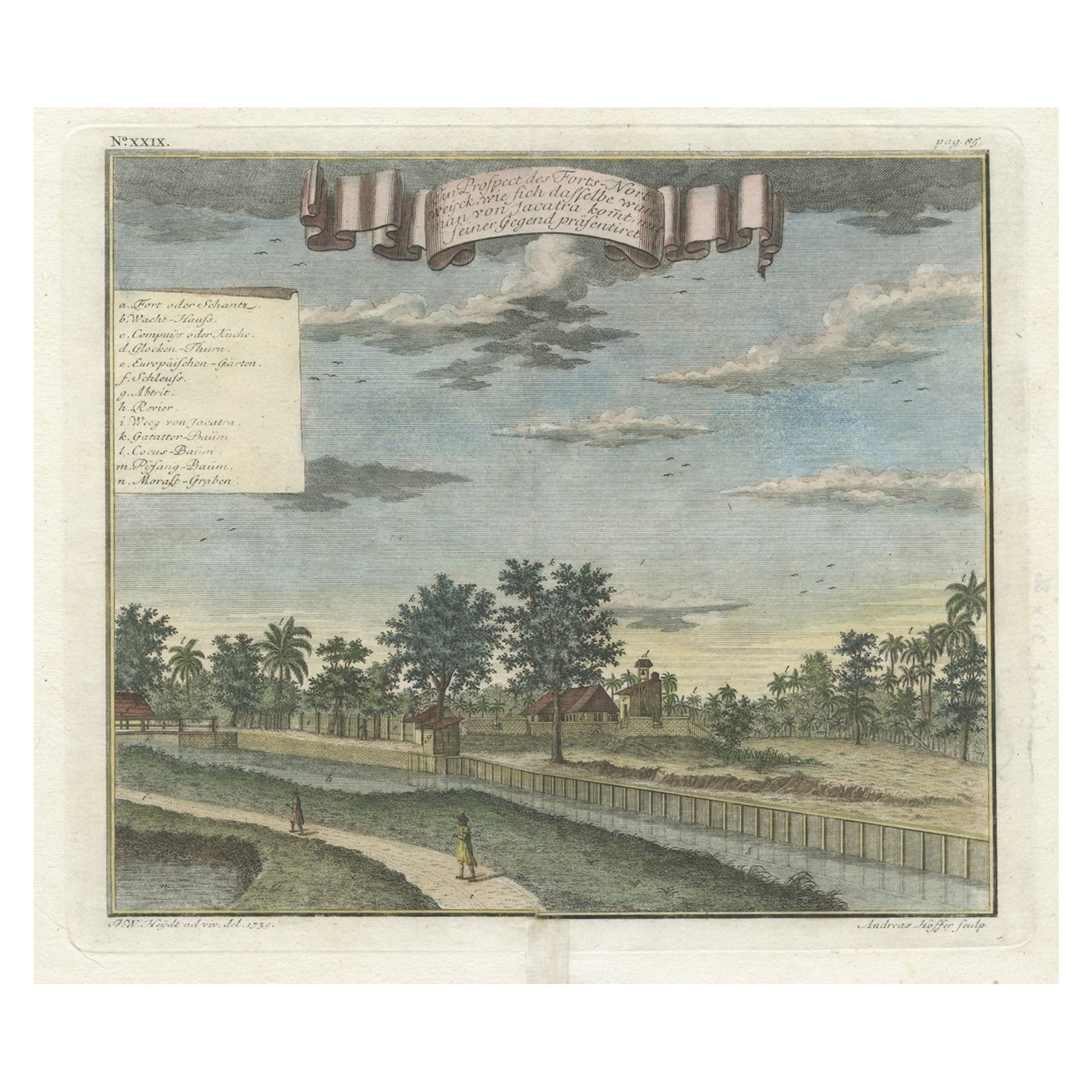
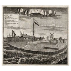
- Old Antique Print of Fort Noordwijk, Batavia 'Jakarta, Indonesia', 1739Located in Langweer, NLAntique print titled 'Ein Prospect des Forts Nortweijck, wie sich dasselbe wan man von Jacatra komt, mit seiner Gegend präsentiret'. Old print of Fort Noordwijk, Batavia (Jakarta)....Category
Antique 1730s Prints
MaterialsPaper
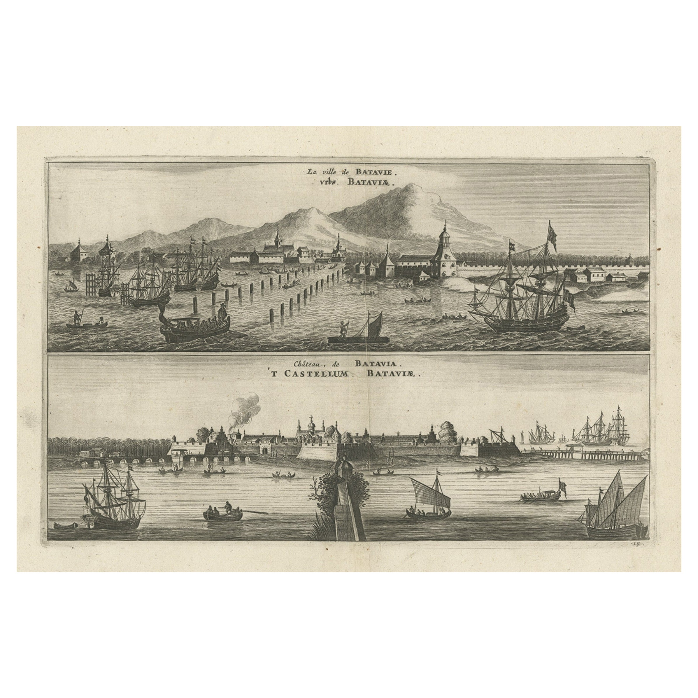
- Old Print with a View on the City & Castle of Batavia 'Jakarta', Indonesia, 1668Located in Langweer, NLAntique print Indonesia titled ‘La ville de Batavie. De Stadt Batavia. Chateau de Batavia. ‘t Casteel van Batavia’. Antique print with a view on the city of Djakarta, Indonesia. ...Category
Antique 1660s Prints
MaterialsPaper
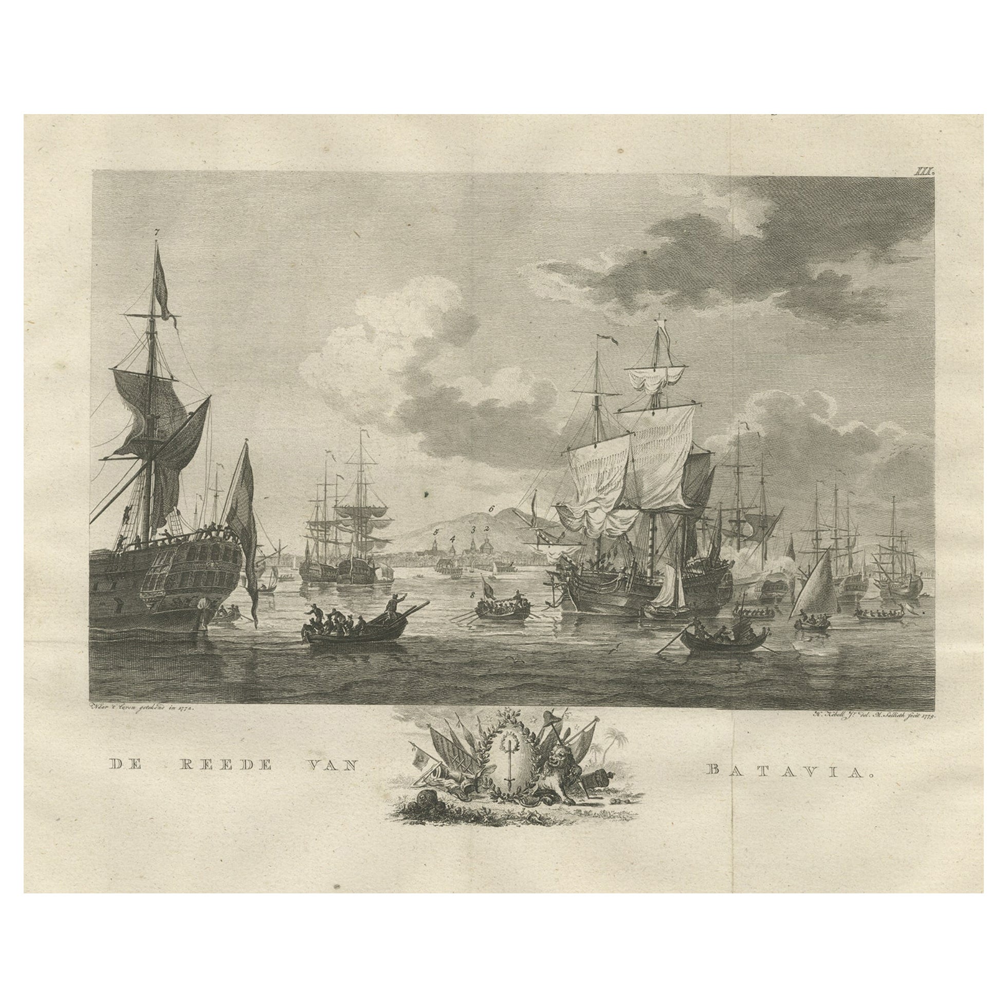
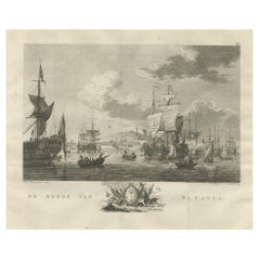
- Old Print of VOC Ships in the Sea Near Batavia (Jakarta, Indonesia), 1779Located in Langweer, NLAntique print Batavia titled 'De Reede van Batavia'. Beautiful view of the sea near Batavia (Jakarta, Indonesia), with several ships lying at anchor. Artists and Engravers: Ma...Category
Antique 1770s Maps
MaterialsPaper
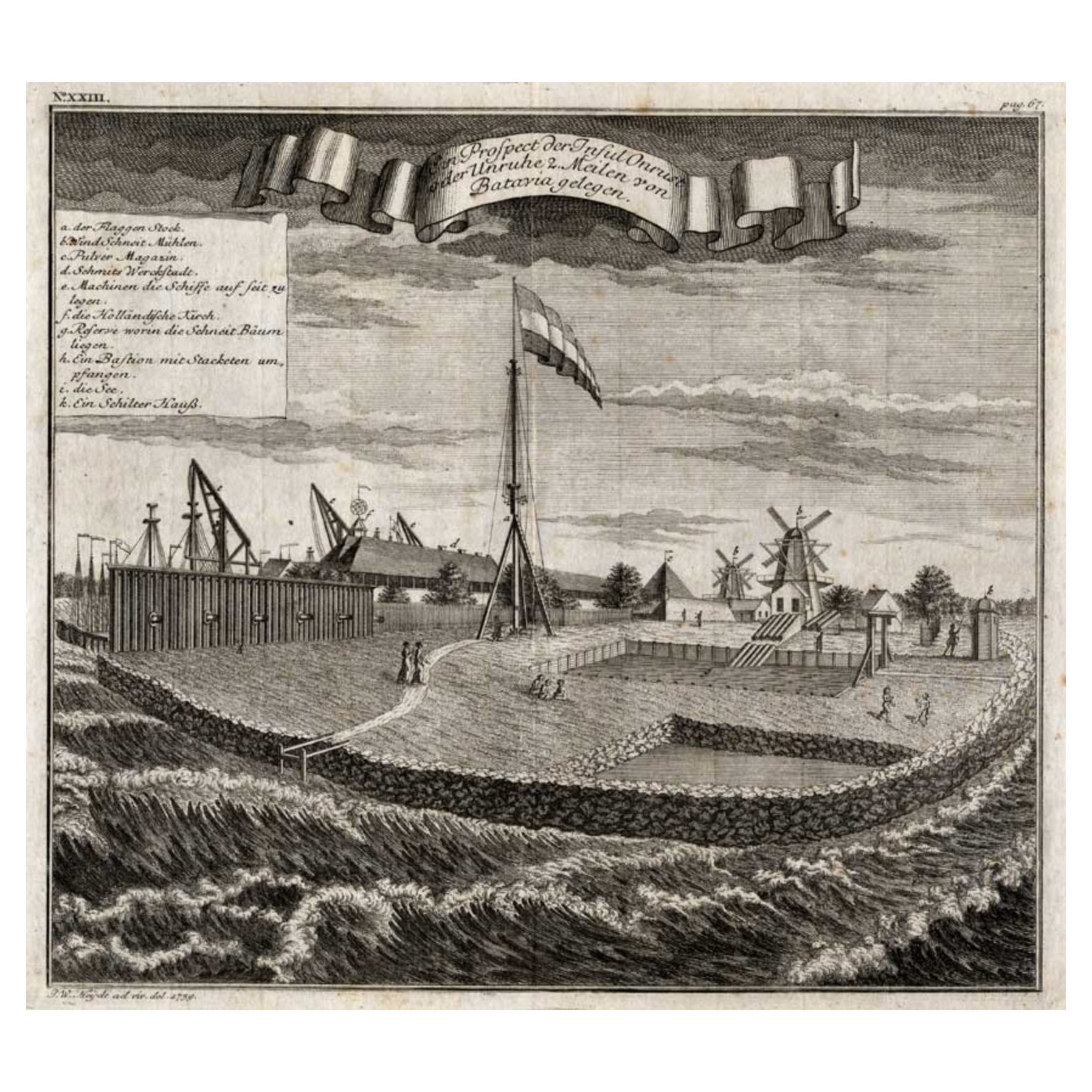
- View of the Island Onrust Near Batavia 'Jakarta', Indonesia, 1739Located in Langweer, NLAntique print titled 'Ein Prospect der Insul Onrust oder Unruhe 2 Meilen von Batavia gelegen.' (View of the island ' Onrust' near Batavia.) Onrust Island also known as Pulau Onrust or Pulau Kapal (ship island) is an Indonesian island off the coast of Jakarta. It measures about 3.5 km2 (1.4 sq mi) and is part of the Thousand Islands. The town on the island had houses and warehouses, but it also had a gunpowder magazine, a storage for water transported from Batavia, general warehouses, and a lot of warehouses specifically meant to store pepper. Specific to the shipyard were the reservoirs for trees. Sawing windmills processed these trees to make planks for the shipyards. There was also a smithy that served the shipyard. Near the waterfront there were special installations to easily pull ships on their side. Sometimes ships for local use were built at the island. The VOC employees were only allowed to leave the island two times a year. In 1911 Onrust Island was turned into a quarantine station for pilgrims returning from the Hajj. The island had the advantage of being completely isolated. Furthermore, it was so small that it was possible to make it malaria free by the only method known at the time. This was done by filling up all the small ponds and other fresh water instances on the island and by removing most vegetation. Later a sanatorium for lung diseases was established on the island, because of the very much improved health situation. From 1933 it was used to lock up the mutineers of the 1933 mutiny on the HNLMS De Zeven Provinciën (1909). In 1940 German nationals were interned on Onrust. In May 1940 the Netherlands were attacked by Germany. In the Dutch East Indies thousands of Germans, Hungarians, Czechs, Italians, Dutchmen with a German family name, and members of the National Socialist Movement in the Netherlands were arrested and locked up at Onrust and in Ngawai. After war with Japan broke out on 8 December 1941 a small part of these prisoners was evacuated to Suriname. The Japanese also used Onrust as a prison. On 23 January 1950 Raymond Westerling attempted the APRA coup d'état. It failed, and most of the APRA military were seized by the Dutch troops that were still on Java. The Dutch military...Category
Antique 1730s Maps
MaterialsPaper
You May Also Like
- Old Nautical Print Depicting the Bombardment of Cadiz by the French Navy 1823Located in Milan, ITPrint by engraving on copper plate of the first half of the 19th century, depicting the bombardment of Cadiz by the French Navy, 23 September 1823. The print is signed peint par Crep...Category
Antique 1830s French Nautical Objects
MaterialsPaper
- The Holy Land at the Time of Jesus: A 17th Century Dutch Map by VisscherBy Nicolaes Visscher IILocated in Alamo, CAThis detailed Dutch map entitled "Het Beloofe de Landt Canaan door wandelt van onsen Salichmaecker Iesu Christo, nessens syne Apostelen" by Nicolaes Visscher was published in Amsterd...Category
Antique Mid-17th Century Dutch Maps
MaterialsPaper
- New Map of North America from the Latest Discoveries, 1763Located in Philadelphia, PAA fine antique 18th century map of the North American seaboard. Entitled "A New Map of North America from the Latest Discoveries 1763". By the Cartographer/Engraver - John Spil...Category
Antique Mid-18th Century English Georgian Maps
MaterialsPaper
- Old Nautical Map of CorsicaLocated in Alessandria, PiemonteST/556/1 - Old map of Corsica isle, surveyed by Captain Hell, of the French Royal Navy in 1824, engraved and published on 1874, with additions and corre...Category
Antique Early 19th Century English Other Prints
MaterialsPaper
- Old Horizontal Map of EnglandBy TassoLocated in Alessandria, PiemonteST/520 - Old rare Italian map of England, dated 1826-1827 - by Girolamo Tasso, editor in Venise, for the atlas of M.r Le-Sage.Category
Antique Early 19th Century Italian Other Prints
MaterialsPaper
- Map of the Republic of GenoaLocated in New York, NYFramed antique hand-coloured map of the Republic of Genoa including the duchies of Mantua, Modena, and Parma. Europe, late 18th century. Dimension: 25...Category
Antique Late 18th Century European Maps


Recently Viewed
View AllMore Ways To Browse
Tapestry Flower
Curtis Jere Brass Wall Sculpture
European Antique Imports
19th Century French Antique Commode
Iron Door Large
Antique Museum Cabinet
Flower Wall Sculptures
Desk Antique Desk London Furniture Desks
Commode White Marble
Glass Backed Brass Cabinet
Antique 4 Chest Of Drawers
Antique Door Sets
Antique Chest Of Drawers 4 Drawers
Floral 90s
Narrow Door
Swiss Vintage Shop
Antique Silver Wedding
Vintage Industrial Cabinet 20th Century