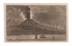
Items Similar to Old Engraving of Volcano Piton de la Fournaise on Reunion Island, c.1750


Want more images or videos?
Request additional images or videos from the seller
1 of 6
Old Engraving of Volcano Piton de la Fournaise on Reunion Island, c.1750
$229.04
$286.3020% Off
£169.33
£211.6620% Off
€192
€24020% Off
CA$315.04
CA$393.8020% Off
A$350.19
A$437.7320% Off
CHF 183.56
CHF 229.4520% Off
MX$4,276.62
MX$5,345.7820% Off
NOK 2,291.64
NOK 2,864.5520% Off
SEK 2,156.01
SEK 2,695.0120% Off
DKK 1,461.69
DKK 1,827.1220% Off
About the Item
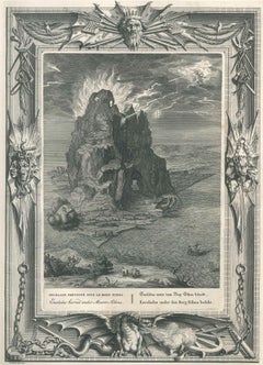
Antique print titled 'Eiland van St. Filippus, of van Fuego, met zyn vuurberg'. Old print of Piton de la Fournaise, a shield volcano on the eastern side of Reunion island near the town of Saint-Philippe. Engraved by J. van Schley for a Dutch edition of 'l'Histoire Generale des Voyages', by Antoine François Prévost (the Abbé Prévost).
Artists and Engravers: Jakob van der Schley (Amsterdam 1715-1779) was a Dutch draughtsman and engraver. He studied under Bernard Picart and became heavily influenced by his style.
Condition: Very good, general age-related toning. Two small holes outside image. Please study image carefully.
Date: c.1750
Overall size: 20 x 25.3 cm.
Image size: 13.9 x 19.7 cm.
Whilst cartography holds a special place in our collection, we also offer thousands of antique prints covering fields of interest as diverse as architecture, natural history, religion, ethnology and many more. Antique prints have long been appreciated for both their aesthetic and investment value. They were the product of engraved, etched or lithographed plates. These plates were handmade out of wood or metal, which required an incredible level of skill, patience and craftsmanship. Whether you have a house with Victorian furniture or more contemporary decor an old engraving can enhance your living space.
- Creator:Jakob van der Schley (Artist)
- Dimensions:Height: 9.97 in (25.3 cm)Width: 7.88 in (20 cm)Depth: 0 in (0.01 mm)
- Materials and Techniques:
- Period:
- Date of Manufacture:circa 1750
- Condition:Condition: Very good, general age-related toning. Two small holes outside image. Please study image carefully.
- Seller Location:Langweer, NL
- Reference Number:Seller: CD-122851stDibs: LU3054329333202
About the Seller
5.0
Recognized Seller
These prestigious sellers are industry leaders and represent the highest echelon for item quality and design.
Platinum Seller
Premium sellers with a 4.7+ rating and 24-hour response times
Established in 2009
1stDibs seller since 2017
2,604 sales on 1stDibs
Typical response time: <1 hour
- ShippingRetrieving quote...Shipping from: Langweer, Netherlands
- Return Policy
Authenticity Guarantee
In the unlikely event there’s an issue with an item’s authenticity, contact us within 1 year for a full refund. DetailsMoney-Back Guarantee
If your item is not as described, is damaged in transit, or does not arrive, contact us within 7 days for a full refund. Details24-Hour Cancellation
You have a 24-hour grace period in which to reconsider your purchase, with no questions asked.Vetted Professional Sellers
Our world-class sellers must adhere to strict standards for service and quality, maintaining the integrity of our listings.Price-Match Guarantee
If you find that a seller listed the same item for a lower price elsewhere, we’ll match it.Trusted Global Delivery
Our best-in-class carrier network provides specialized shipping options worldwide, including custom delivery.More From This Seller
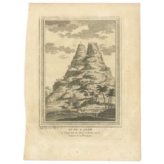
View AllAntique Print of Adam's Peak in Sri Lanka, by Arkstee & Merkus, 1761
Located in Langweer, NL
Antique print titled 'Le Pic d'Adam'. View of Adam's Peak, a tall conical mountain located in central Sri Lanka. This print originates from 'Histoire generale des voyages ou nouvelle...
Category
Antique 18th Century Prints
Materials
Paper
$124 Sale Price
20% Off
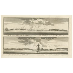
Antique Engraving of Tinian, an Island of the Northern Mariana Islands, 1757
Located in Langweer, NL
Antique print titled 'Vue de la Rde de Tinian
Gezigt van de Rheede van Tinian (..)'. Views of the south-west side of the island of Tinian and a view of the anchorage of Tinian, w...
Category
Antique 1750s Prints
Materials
Paper
$343 Sale Price
20% Off
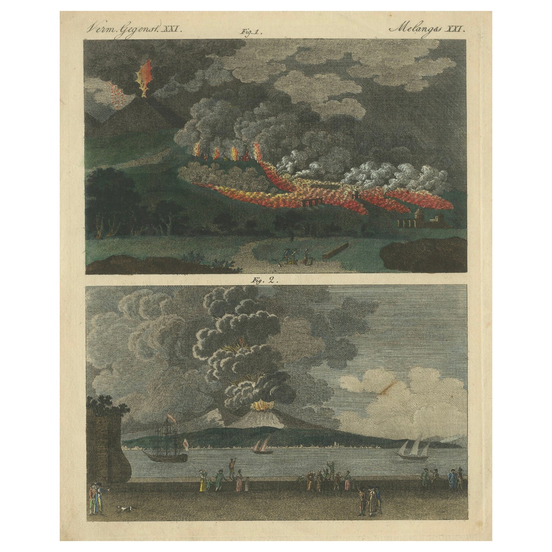
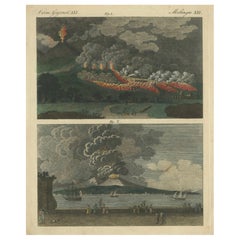
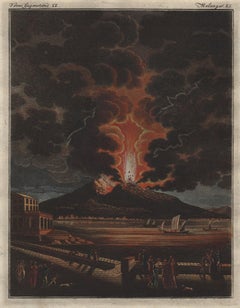
1798 Engraving of Mt. Vesuvius Eruptions - Lava in 1760, Ashes in 1794
Located in Langweer, NL
1798 Engraving of Mt. Vesuvius Eruptions - Lava in 1760, Ashes in 1794
Description: This 1798 hand-coloured copperplate engraving is from Johann Ludwig Bertuch's "Bilderbuch für Kin...
Category
Antique 1790s Prints
Materials
Paper
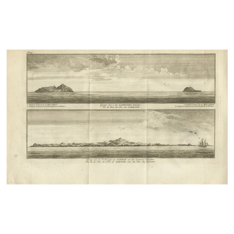
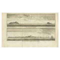
Antique Print with Views of the Ladrones Islands and Saipan by Anson, 1749
Located in Langweer, NL
Antique print titled 'Gezigt van 2 der Ladrones Eilanden' and 'Gezigt van de N.W. zyde van Saypan'. Coastal views of the Ladrones Islands and the island of Saipan. This print origina...
Category
Antique 18th Century Prints
Materials
Paper
$219 Sale Price
29% Off
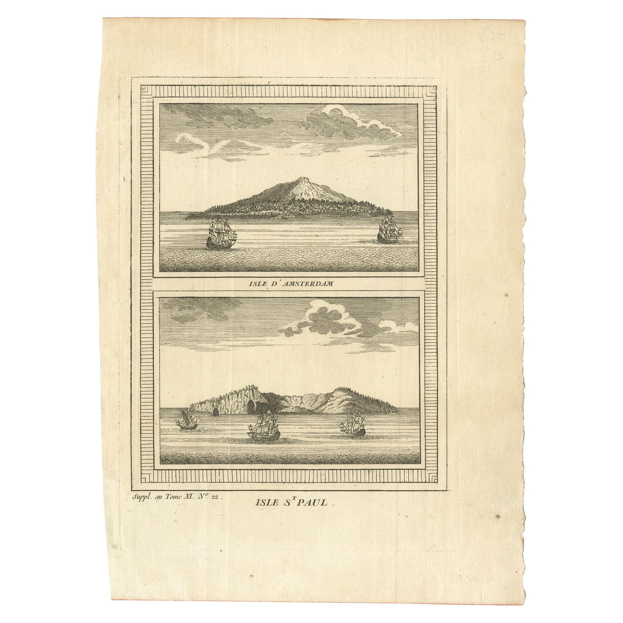
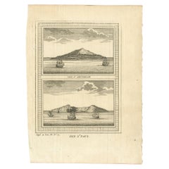
Antique Print of Amsterdam and St. Paul Island by Bellin '1753'
By Jacques-Nicolas Bellin
Located in Langweer, NL
Antique print titled 'Isle d'Amsterdam, Isle St. Paul'. Two images on one sheet depicting Amsterdam and St. Paul island. The Dutch captain Anthonie van Diemen named it island Nieuw Amsterdam...
Category
Antique Mid-18th Century French Prints
Materials
Paper
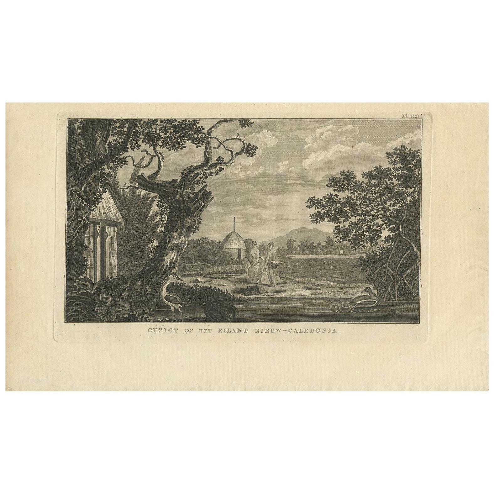
Antique Print of New Caledonia Island by Cook, 1803
Located in Langweer, NL
Antique print titled 'Gezigt op het Eiland Nieuw-Caledonia'. This print depicts a view of New Caledonia Island. Originates from 'Reizen rondom de Waereld...
Category
Antique Early 19th Century Dutch Prints
Materials
Paper
$238 Sale Price
20% Off
You May Also Like
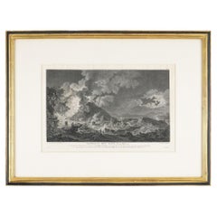
The Eruption of Vesuvius 14 May 1771 by Heinrich Guttenberg, c. 1800
Located in Kenilworth, IL
Eruption du Mont Vésuve, du 14 Mai, 1771 (Eruption of Mt. Vesuvius, May 14, 1771) is an engraving by Heinrich Guttenberg after a painting by Pierre-Jacques Volaire.
In this imposing...
Category
Antique 19th Century Prints
Materials
Paper
Sescape With Vesuvio and Boats - Etching by Filippo Morghen - 18th Century
By Filippo Morghen
Located in Roma, IT
Seascape With Vesuvio and Boats is an Etching realized by Filippo Morghen (1730-1807).
The etching belongs to the print suite “Antiquities of Herculaneum Exposed” (original title: ...
Category
Late 18th Century Old Masters Figurative Prints
Materials
Etching
Vesuvius, Naples, Italy. Volcano, engraving with original hand-colouring, 1815
Located in Melbourne, Victoria
Vesuvius, engraving with original hand-colouring, 1815.
From Bilderbuch Zum Nutzen und Vergnugen Der Jugend by Friedrich Justin Bertuch (1747-1822), an encyclopaedic collection of I...
Category
Early 19th Century Naturalistic Landscape Prints
Materials
Engraving
Encelade, from "Temple des Muses" - Original Etching by Bernard Picart - 1742
By Bernard Picart
Located in Roma, IT
Black and white etching on wire rod paper, representing the Greek myth of Encelade, burried under the Mount Ethna.
Beautiful plate with fresh impression, from the volume “Le Temple ...
Category
1740s Old Masters Figurative Prints
Materials
Etching
French Neoclassic Engraving, Vue de La Caverne du Dragon, early 19th century
Located in Atlanta, GA
The hand colored engraving by Descourtis depicting a true cave in the Orange region of France with curious admirers with a dog and a soldier, in a period walnut and ebonized frame
Category
Antique Early 1800s French Neoclassical Prints
Materials
Walnut
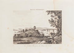
La Pointe à Pitre prise du Morne - Original Lithograph - 19th Century
Located in Roma, IT
La Pointe à Pitre prise du Morne is an original lithograph realized by an Anonymous artist of the 19th Century.
Realized within the series of "France Pittor...
Category
19th Century Landscape Prints
Materials
Lithograph
More Ways To Browse
Pompeii Wall Painting
Priest Japanese
Rooster Garden
Rosewood Record
Santo Head
Sarreid Brass Spain
Scandinavian China Cabinet
Sculpture Cheval
Sea Shell Glass Tables
Serpentine Secretary
Shishi Lion
Signed Ginger Jars
Spanish Baroque Columns
St Charles Kitchen
Sterling Cane
Stone Bench With Back
Stork Gold
Swatch 1993