Items Similar to Territory Of The Potomac Hunt

Want more images or videos?
Request additional images or videos from the seller
1 of 6
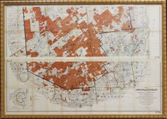
C.W. Owen, Jr Territory Of The Potomac Hunt1948
1948
$750
£585.81
€664.09
CA$1,075.21
A$1,179.45
CHF 617.10
MX$14,037.75
NOK 7,794.40
SEK 7,311.29
DKK 4,959.76
About the Item
Classic map compiled by: C.W. Owen, Jr 1948 of the 'Territory of the Potomac Hunt' Kennels: Travilah, MD
Map Sz: 17"H x 18"W
Frame Sz: 22"H x 23"W
The Potomac Hunt is one of Maryland’s most widely recognized fox hunts and has been in operation since 1931. During the season we hunt an award-winning pack of American Foxhounds twice a week at various locations throughout upper Montgomery County.
- Creator:C.W. Owen, Jr
- Creation Year:1948
- Dimensions:Height: 22 in (55.88 cm)Width: 23 in (58.42 cm)
- Medium:
- Period:
- Condition:
- Gallery Location:Bristol, CT
- Reference Number:Seller: 153971stDibs: LU1260112133192
About the Seller
4.8
Vetted Professional Seller
Every seller passes strict standards for authenticity and reliability
Established in 2000
1stDibs seller since 2019
135 sales on 1stDibs
Typical response time: 1 hour
- ShippingRetrieving quote...Shipping from: Bristol, CT
- Return Policy
More From This Seller
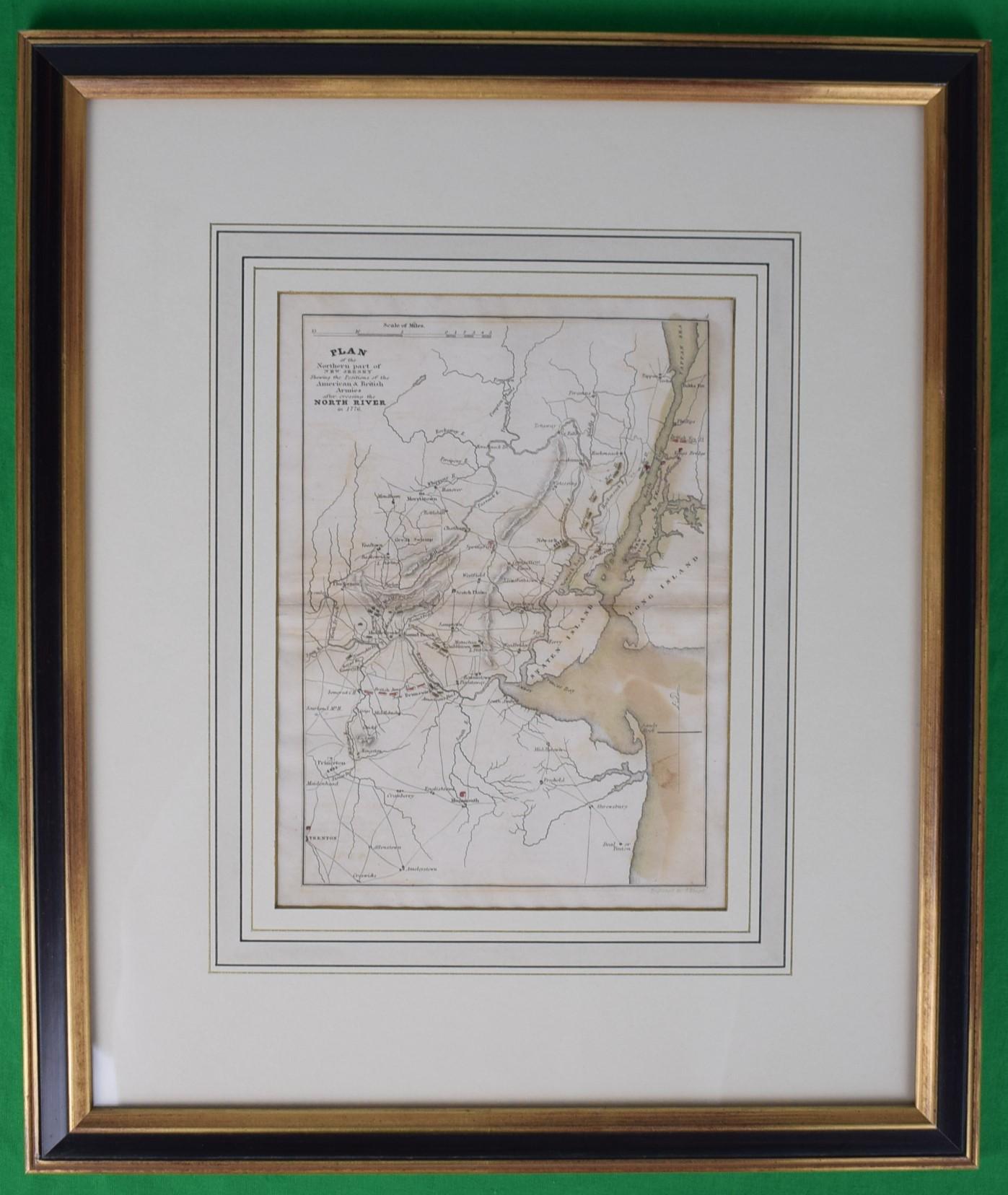
View AllPlan Of The Northern Part Of New Jersey Showing The Positions Of The American &
By Richard Phillips
Located in Bristol, CT
After Crossing The North River in 1776
Map Sz: 9 7/8"H x 7 1/4"W
Frame Sz: 18 5/8"H x 15 3/4"W
Engraved by J Yeagen
Uncolored map of Northern New Jersey, Staten Island and the lo...
Category
Early 1800s Prints and Multiples
Materials
Lithograph
American Revolution Map Drawn For John Marshall's "Life Of Washington" First Acc
Located in Bristol, CT
A Map Of The Country Which Was The Scene Of Operations Of The Northern Army: Including The Wilderness Through Which Gerneral Arnold Marched To Attack Plate VI
Map Sz: 11"H x 9 1/4"W...
Category
Early 1800s Prints and Multiples
Materials
Paper, Engraving
"Rhode Island Map, 1933"
Located in Bristol, CT
Classic c1933 colour (12 fold) red framed map of Rhode Island designed by H.W. Hetherington from Narragansett Bay to Buzzard's Bay
Map Sz: 17 3/8"...
Category
1930s Prints and Multiples
Materials
Lithograph
"Off To Draw" 1951 Fox-Hunt Monkton, MD by Edward S. Voss
Located in Bristol, CT
Edward S. Voss M.F.H. Monkton, MD
"Off To Draw"
Color lithograph on paper
Published 1951 by My Lady's Manor Ltd Monkton, Maryland
Signed in plate to lower right
Print Sz 11 1/4"H x 14"W
Frame Sz 19 1/4"H x 21 3/4"W
Edward (Ned) Voss rode in point-to-points (his last ride came at age 64 in 1957) and campaigned steeplechase horses like *Golpista, Flying Artist and *Atamisqui with trainer Burley Cocks. Atlanta Hall was also home to Belgian draft horses and purebred Angus cattle...
Category
1950s Landscape Prints
Materials
Lithograph

1911 No's 3 & 4 Map Of The Adirondack Forest
Located in Bristol, CT
Map Sz: 38 1/2"H x 55 1/2"W
Frame Sz: 40"H x 57"W
Category
1910s More Art
Materials
Paper
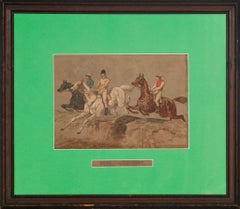
"Here They Come" by J.F. Herring Sr
Located in Bristol, CT
Colourful chromolithograph by J. F. Herring, Sr. (1795-1865) entitled "Here They Come" depicting three gentlemen jockeys
Print Sz: 7"H x 10"W
Frame Sz: 16"H x 17"W
Category
19th Century Prints and Multiples
Materials
Lithograph
You May Also Like
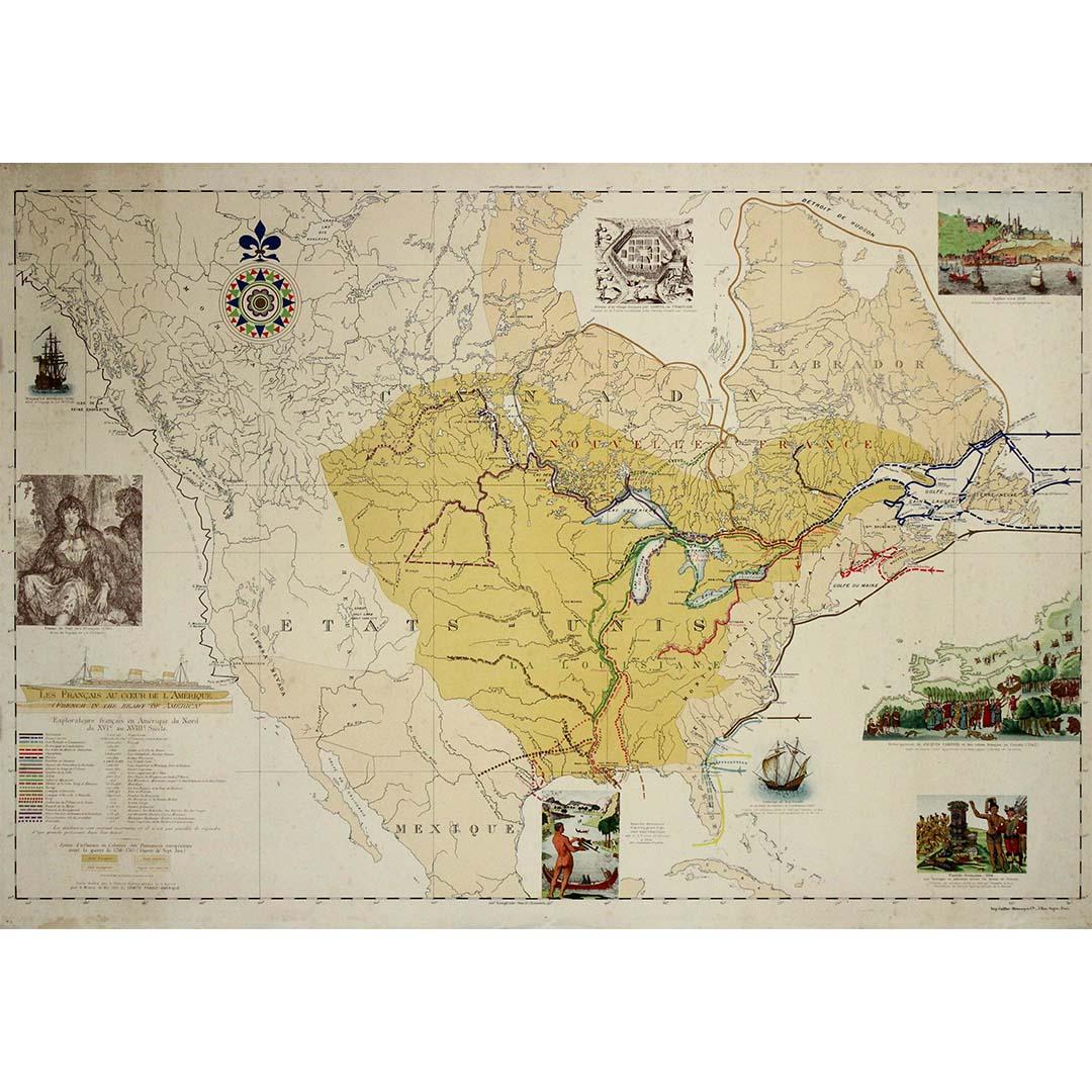
1935 original map French exploration in North America
Located in PARIS, FR
In 1935, a remarkable map titled "Les Français au Cœur de l'Amérique" was produced, highlighting the rich history of French exploration and influence in North America. This map is a ...
Category
1930s Prints and Multiples
Materials
Lithograph, Paper
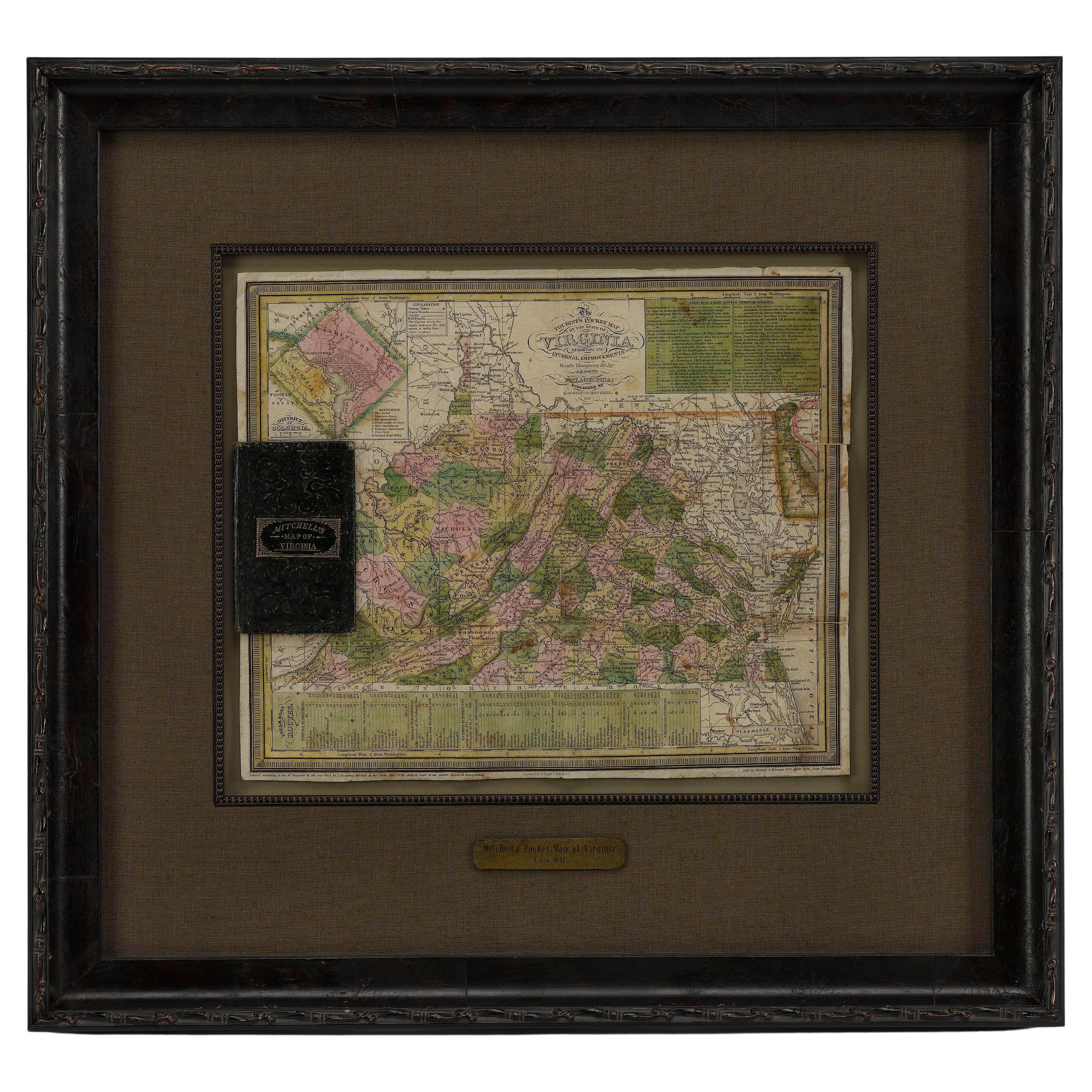
1837 Mitchell's "Tourist's Pocket Map of the State of Virginia" by J.H. Young
Located in Colorado Springs, CO
This is J. H. Young's pocket map of the Virginia, which shows county development current to 1835. The map was engraved by E. Yeager and F. Dankworth and published by S. A. Mitchell. ...
Category
Antique 1830s American Maps
Materials
Paper

Antique 18th Century Map of the Province of Pensilvania 'Pennsylvania State'
Located in Philadelphia, PA
A fine antique of the colony of Pennsylvania.
Noted at the top of the sheet as a 'Map of the province of Pensilvania'.
This undated and anonymous map is thought to be from the Gentleman's Magazine, London, circa 1775, although the general appearance could date it to the 1760's.
The southern boundary reflects the Mason-Dixon survey (1768), the western boundary is placed just west of Pittsburgh, and the northern boundary is not marked.
The map has a number of reference points that likely refer to companion text and appear to be connected to boundaries. The western and southern boundaries are marked Q, R, S, for example. A diagonal line runs from the Susquehanna R to the Lake Erie P. A broken line marked by many letters A, B, N, O, etc., appears in the east.
There are no latitude or longitude markings, blank verso.
Framed in a shaped contemporary gilt wooden frame and matted under a cream colored matte.
Bearing an old Graham Arader Gallery...
Category
Antique 18th Century British American Colonial Maps
Materials
Paper

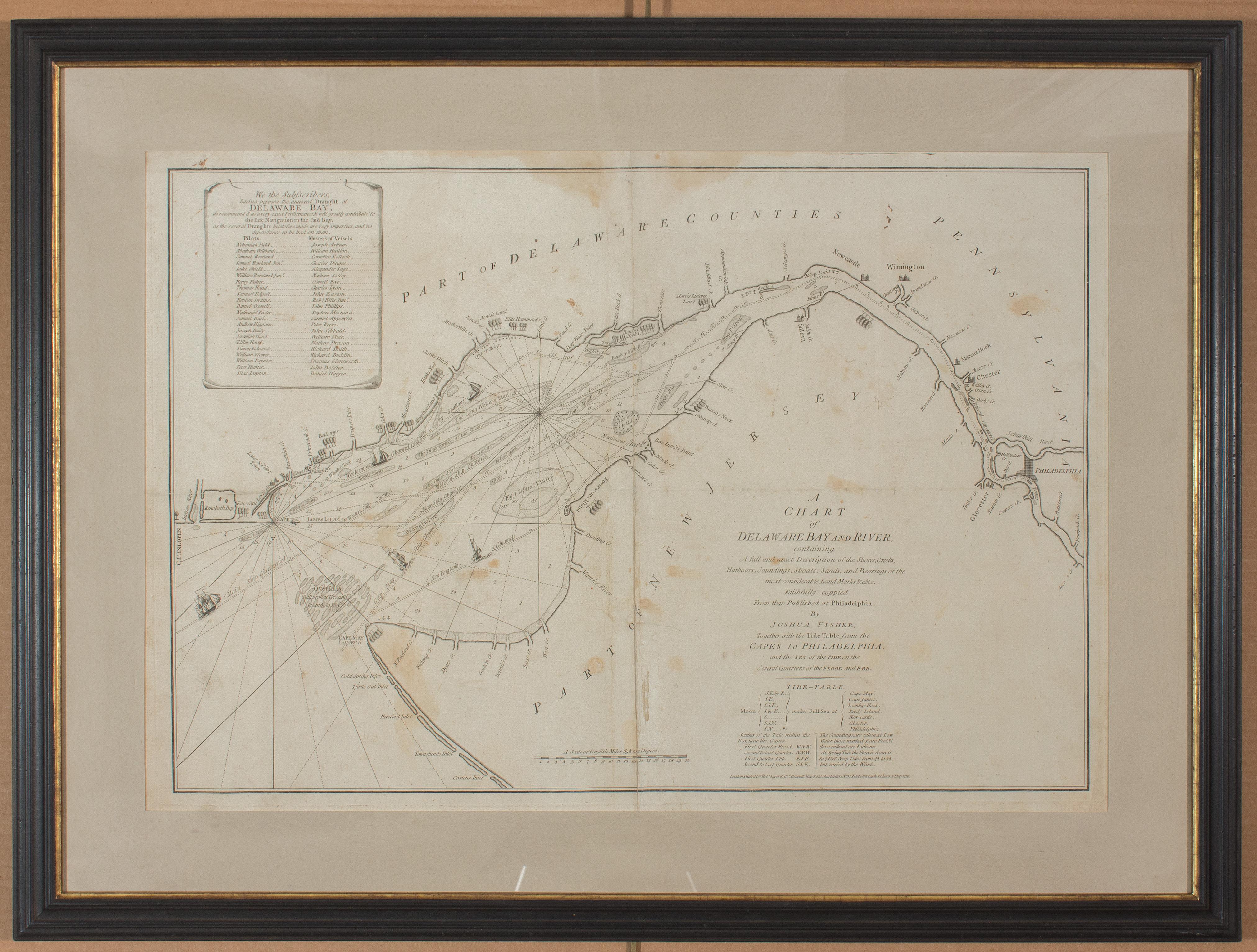
1776 Navigational chart/map of the Delaware bay and river including Philadelphia
Located in Philadelphia, PA
JOSHUA FISHER
(AMERICAN, EIGHTEENTH CENTURY)
A Chart of Delaware Bay and River, 1776
Printed for John Bennet and Robert Sayer, London
Engraving on pape...
Category
1770s Realist Landscape Prints
Materials
Paper, Engraving

1864 Johnson's Map of Virginia, Delaware, and Maryland with Fort Monroe Inset
Located in Langweer, NL
Title: 1864 Johnson's Map of Virginia, Delaware, and Maryland with Fort Monroe Inset
Description: This 1864 map titled "Johnson's Virginia, Delaware, and ...
Category
Antique 1860s Maps
Materials
Paper
$282 Sale Price
20% Off
1856 U.S. Coast Survey Map of Chesapeake Bay and Delaware Bay
Located in Colorado Springs, CO
Presented is U.S. Coast Survey nautical chart or maritime map of Chesapeake Bay and Delaware Bay from 1856. The map depicts the region from Susquehanna, Maryland to the northern Outer Banks in North Carolina. It also shows from Richmond and Petersburg, Virginia to the Atlantic Ocean. The map is highly detailed with many cities and towns labeled throughout. Rivers, inlets, and bays are also labeled. Various charts illustrating more specific parts of the region are marked on the map using dotted lines. The lines form boxes, and the corresponding chart number and publication date are given. Extensive triangulation surveys were conducted the length of Chesapeake Bay and are illustrated here. Hampton Roads, Virginia is labeled, along with the James, York, and Rappahannock Rivers, which were all extensively surveyed.
The chart was published under the supervision of A. D. Bache, one of the most influential and prolific figures in the early history of the U.S. Coast Survey, for the 1856 Report of the Superintendent of the U.S. Coast Survey. Alexander Dallas Bache (1806-1867) was an American physicist, scientist, and surveyor. Bache served as the Superintendent of the U.S. Coast Survey from 1843 to 1865. Born in Philadelphia, Bache toured Europe and composed an important treatise on European Education. He also served as president of Philadelphia's Central High School and was a professor of natural history and chemistry at the University of Pennsylvania. Upon the death of Ferdinand Rudolph Hassler, Bache was appointed Superintendent of the United States Coast Survey.
The Office of the Coast Survey, founded in 1807 by President Thomas Jefferson and Secretary of Commerce Albert Gallatin...
Category
Antique 1850s American Maps
Materials
Paper
