Items Similar to "Britannia"


Want more images or videos?
Request additional images or videos from the seller
1 of 12
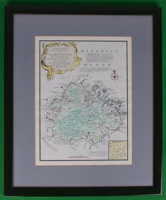
Dr William Smith's Ancient Atlas"Britannia"
$750
£581.40
€658.09
CA$1,073.41
A$1,171.33
CHF 607.99
MX$14,013.96
NOK 7,717.32
SEK 7,228.71
DKK 4,915.74
About the Item
Drawn and engraved by Edw. Weller for Dr William Smith's 'Ancient Atlas' plate No. 10
Map Sz: 22 1/2"H x 17 3/8"W
Frame Sz: 27 1/8"H x 22"W
About the Seller
4.8
Vetted Professional Seller
Every seller passes strict standards for authenticity and reliability
Established in 2000
1stDibs seller since 2019
135 sales on 1stDibs
Typical response time: 1 hour
- ShippingRetrieving quote...Shipping from: Bristol, CT
- Return Policy
More From This Seller
View AllMap Of The Island Of Antigua
Located in Bristol, CT
Classic colour plate depicting a 'Map of the Island of Antigua' by Eman Bowen
Print Sz: 13 1/2"H x 10"W
Frame Sz: 20"H x 16 1/2"W
w/ grey mat & green lacquer frame
Emanuel Bowen ...
Category
19th Century Prints and Multiples
Materials
Lithograph
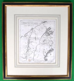
American Revolution Map Drawn For John Marshall's "Life Of Washington" First Acc
Located in Bristol, CT
A Map Of The Country Which Was The Scene Of Operations Of The Northern Army: Including The Wilderness Through Which Gerneral Arnold Marched To Attack Plate VI
Map Sz: 11"H x 9 1/4"W...
Category
Early 1800s Prints and Multiples
Materials
Paper, Engraving
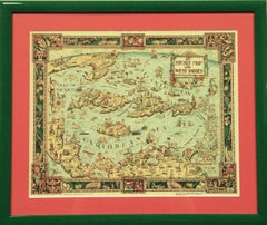
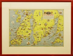
"The Story Map Of The West Indies" 1936
Located in Bristol, CT
Framed colour map of the West Indies published 1936 w/ border design motif adapted from native West Indian handicraft and indigenous tropical fruits
Colorte...
Category
1930s More Prints
Materials
Paper
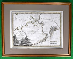
Le Coste Nord Ovest Dell' America E Nord Est Dell' Asia Delineate Sulle Ultime O
Located in Bristol, CT
Map Sz: 14 1/2"H x 19 7/8"W
Frame Sz: 21"H x 26 3/8"W
A fine example of Cassini's 1798 map of Alaska, the Bering Strait, and Siberia. Cassini issued this map in his 1798 atlas to illustrate the discoveries made by James Cook. Cook was the first to accurately chart the Alaskan coastline and provide a detailed mapping of the Aleutian Islands. Cook's zigzagging route is shown as he skirts the Aleutian Islands, passes through the Bering Strait into the Arctic Ocean, and then turns back to sail south along the Siberian Coast. Here the Aleutians are collectively identified as Isole Alessiane, though many of the original islands...
Category
1790s Prints and Multiples
Materials
Paper
"Rhode Island Map, 1933"
Located in Bristol, CT
Classic c1933 colour (12 fold) red framed map of Rhode Island designed by H.W. Hetherington from Narragansett Bay to Buzzard's Bay
Map Sz: 17 3/8"...
Category
1930s Prints and Multiples
Materials
Lithograph
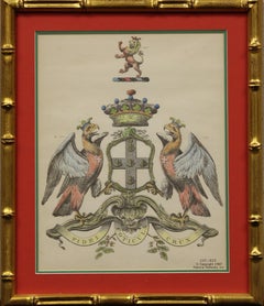
Duke of Buckingham Heraldic Coat-of-Arms
Located in Bristol, CT
Pastel colour heraldic coat-of-arms c.1967 plate
Motto: "The Cross is the Touchstone of Faith"
Motto for the Duke of Buckingham (1592-1628)
Print Sz: 10 1/4"H x 8"W
Frame Sz: 14"...
Category
1960s Prints and Multiples
Materials
Lithograph
You May Also Like
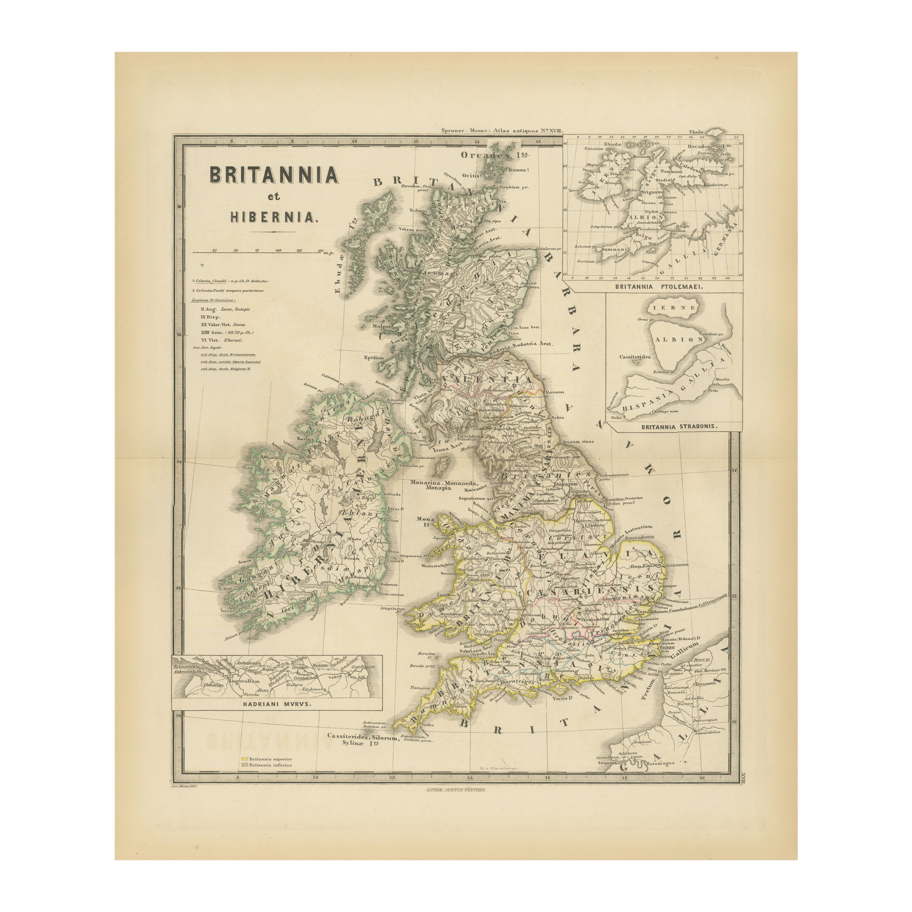
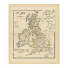
Ancient Cartography of Britannia and Hibernia, Published in 1880
Located in Langweer, NL
This map depicts the geographical area of Great Britain and Ireland, labeled "BRITANNIA et HIBERNIA." It is a historical map, as indicated by the Latin titles and the classical names of regions and tribes.
In the main section of the map, Great Britain is depicted in fine detail, with topographical features such as mountains and rivers. The map is color-coded, to differentiate political or tribal boundaries. Various Roman place names are indicated, such as "Londinium" for London.
To the left of Great Britain is Ireland, referred to as "Hibernia," similarly detailed with its own topographical features and ancient...
Category
Antique 1880s Maps
Materials
Paper
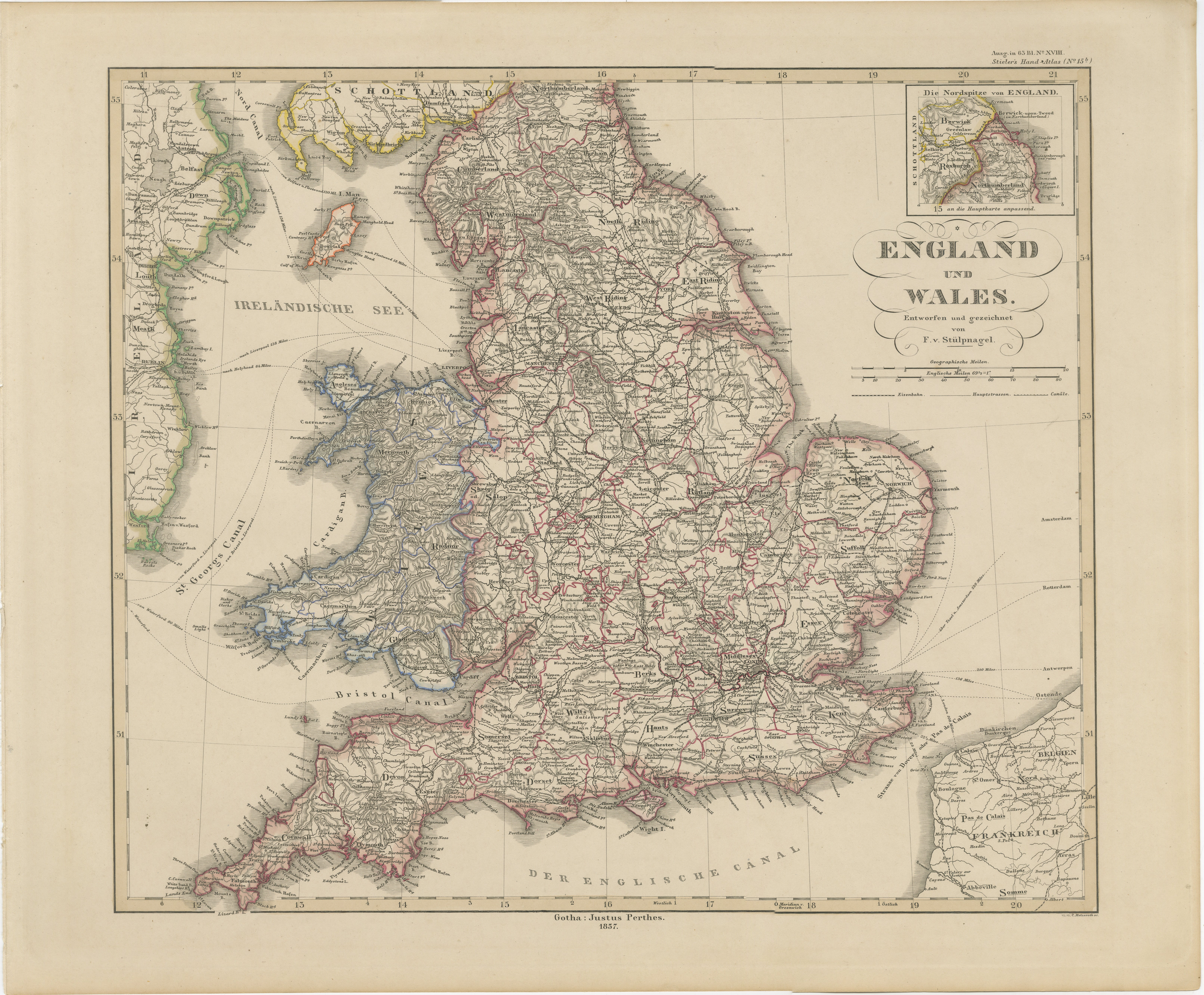
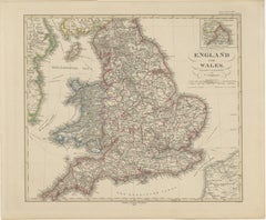
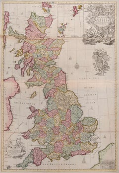
England & Wales in 1857 – Decorative Antique Map with Rail Routes
Located in Langweer, NL
Antique Map of England & Wales – Hand-Colored Engraving by Stülpnagel, 1857
Fine 19th-century map titled "England und Wales", drawn and engraved by Friedrich von Stülpnagel and publ...
Category
Antique Mid-19th Century German Maps
Materials
Paper
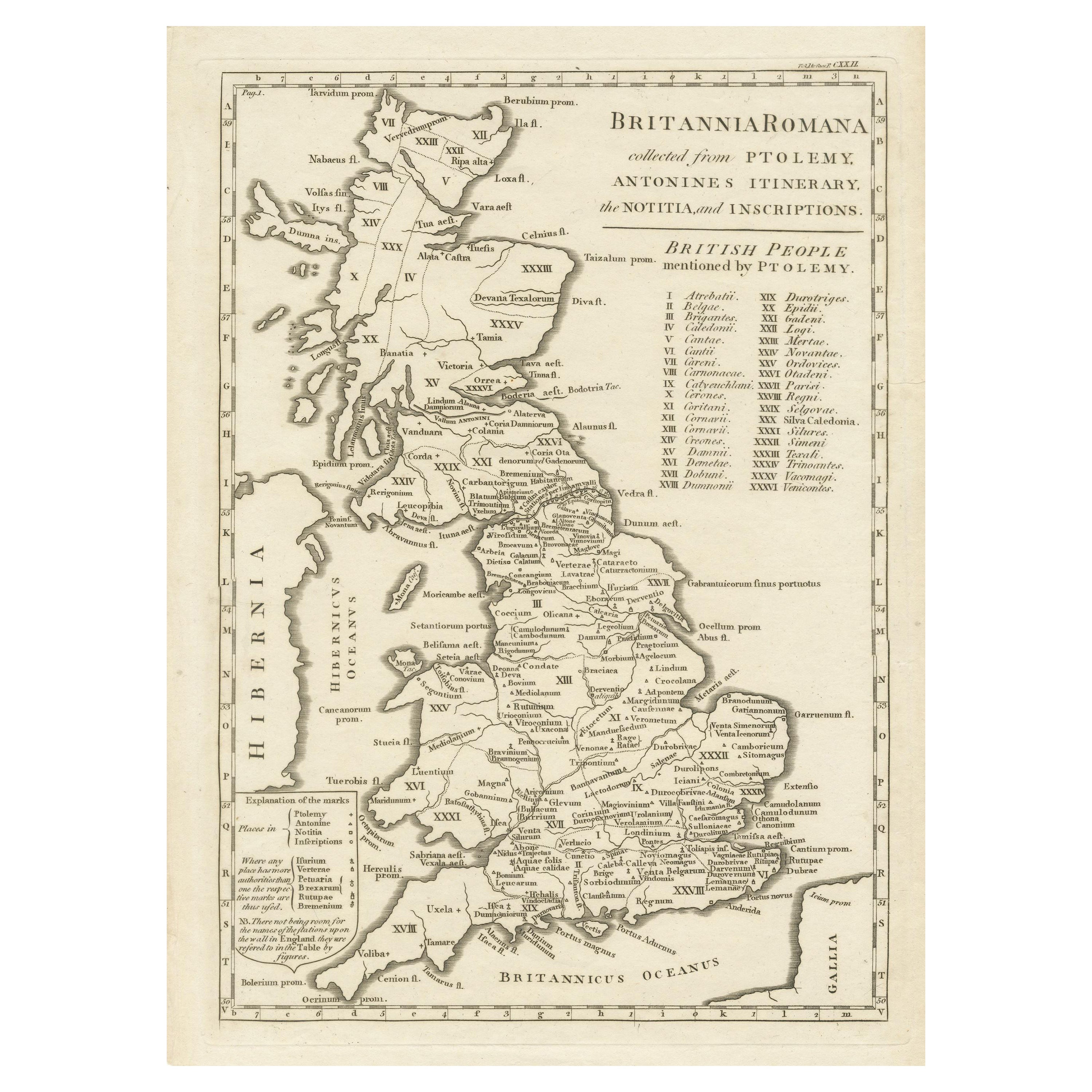
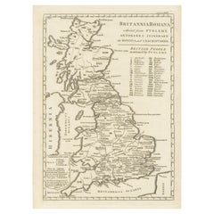
Antique Map of Britain in Roman Times
Located in Langweer, NL
Antique map titled 'Britannia Romana collected from Ptolemy (..)'. Map of Britain in Roman times drawn from several sources, including the works of Ptolemy and The Itinerary of the E...
Category
Antique Early 19th Century Maps
Materials
Paper
$464 Sale Price
20% Off
Great Britain
By John Senex
Located in London, GB
Great Britain
SENEX, John.
A New Map of Great Britain Corrected from the Observations communicated to the Royal Society at London. By John Senex F.R.S. To the Right Hono[ra]ble William Connelly ESQ. One of the Commissioners of His Maj[es]ties Revenue, Speakerof the Hono[a]ble House of Commons, and one of His Maj[es]ties most Hono[ra]ble Privy Council for Ye Kingdom of Ireland. This Map is dedicated by John Senex.
John Senex F.R.S. 1710 [-1728].
John Senex (1678-1740) was one of the foremost mapmakers in England in the early eighteenth century. He was also a surveyor, globemaker, and geographer. As a young man, he was apprenticed to Robert Clavell, a bookseller. He worked with several mapmakers over the course of his career, including Jeremiah Seller and Charles Price...
Category
1710s Naturalistic More Art
Materials
Watercolor, Engraving
Antique Map of England and Wales, Also Showing the English Channel
Located in Langweer, NL
Antique map titled 'England and Wales'. Original antique map of England and Wales. Drawn and engraved by J. Dower. Originates from 'A General Descriptive Atlas Of The Earth, Containi...
Category
Antique Mid-19th Century Maps
Materials
Paper

$142 Sale Price
20% Off
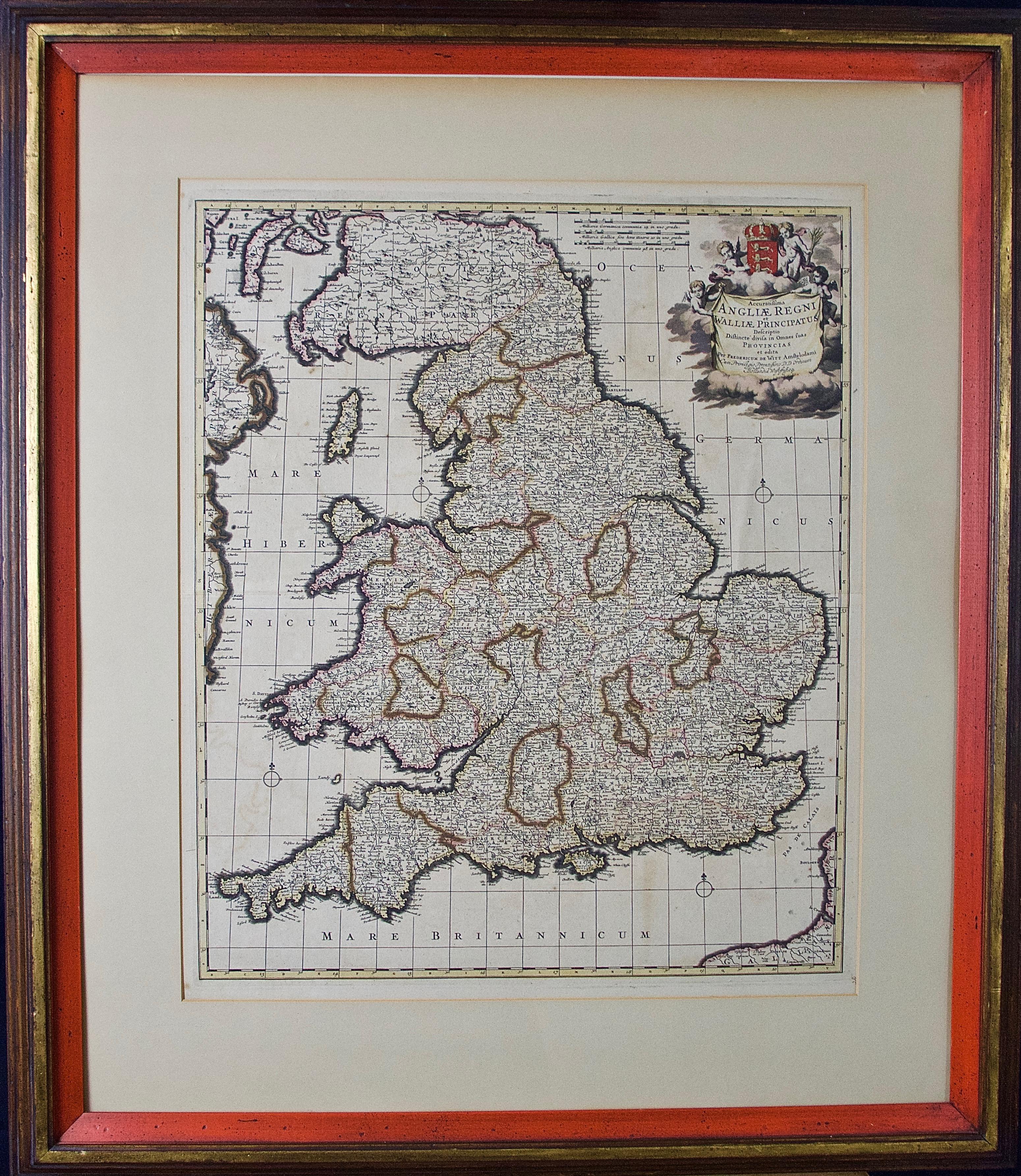
England and the British Isles: A Large 17th Century Hand-colored Map by de Wit
By Frederick de Wit
Located in Alamo, CA
This is a large hand-colored 17th century map of England and the British Isles by Frederick de Wit entitled "Accuratissima Angliæ Regni et Walliæ Principatus", published in Amsterdam in 1680. It is a highly detailed map of England, Scotland, the Scottish Isles...
Category
Late 17th Century Other Art Style Landscape Prints
Materials
Engraving

More Ways To Browse
Ancient Art
Ancient Plate
Tarot Deck
Tennis Vintage Poster
The Rolling Stones Vintage Poster
Trapeze Artist Vintage
Unknown Artist Signature
Vintage Austria Ski Poster
Vintage Bicycle Poster
Vintage Diver Art
Vintage Food Print
Vintage Unicorn Art
Vintage Wildflower Prints
Wren Print
1975 Pop Art
African American Art Signed
Albrecht Durer Etchings
Andre Brasilier