Items Similar to Map of Lymosin-Perigord-Quercye - Original Etching by Antonio Zatta - 1776

Want more images or videos?
Request additional images or videos from the seller
1 of 6
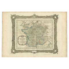
Antonio ZattaMap of Lymosin-Perigord-Quercye - Original Etching by Antonio Zatta - 17761776
1776
$768.85
£580.62
€650
CA$1,075.43
A$1,176.87
CHF 617.21
MX$14,066.08
NOK 7,789.20
SEK 7,266.38
DKK 4,951.38
About the Item
This Map of Lymosin-Perigord-Quercy is an etching realized by Antonio Zatta in Venice in 1776.
The state of preservation of the artwork is good except for the worn paper and the paper is repaired on the middle.
Passepartout 70x50 cm.
On the lower left margin of the map the title "Li Governi del Lymosin-Perigord-Quercy" followed by Antonio Zatta, Venezia 1785.
- Creator:Antonio Zatta (1757 - 1797)
- Creation Year:1776
- Dimensions:Height: 16.54 in (42 cm)Width: 12.6 in (32 cm)Depth: 0.04 in (1 mm)
- Medium:
- Period:1770-1779
- Framing:Framing Options Available
- Condition:Insurance may be requested by customers as additional service, contact us for more information.
- Gallery Location:Roma, IT
- Reference Number:Seller: M-1140151stDibs: LU65037446392
About the Seller
4.9
Platinum Seller
Premium sellers with a 4.7+ rating and 24-hour response times
1stDibs seller since 2017
7,830 sales on 1stDibs
Typical response time: 1 hour
- ShippingRetrieving quote...Shipping from: Roma, Italy
- Return Policy
More From This Seller
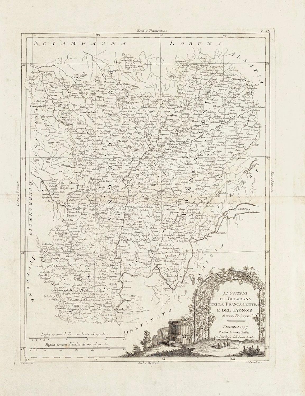
View AllLi Governi di Borgogna - Ancient Map - 1777
Located in Roma, IT
Li Governi di Borgogna is an original black and white etching on paper, printed by Antonio Zatta in Venice, 1777.
Original Title: Li Governi di Borgogna della Franca Contea e del Ly...
Category
1770s Modern Landscape Prints
Materials
Etching

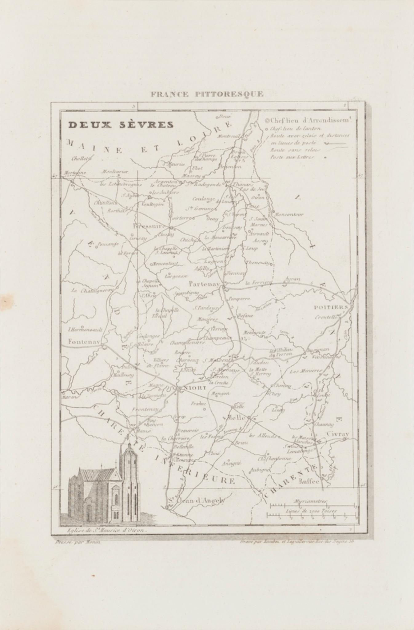
Map of Deux Sèvres - Original Etching - 19th Century
Located in Roma, IT
Map of Deux Sèvres is an original antique etching realized by an anonymous engraver of the 19th Century.
Printed in series of "France Pittoresque" at the top center.
The state of p...
Category
19th Century Modern Figurative Prints
Materials
Etching

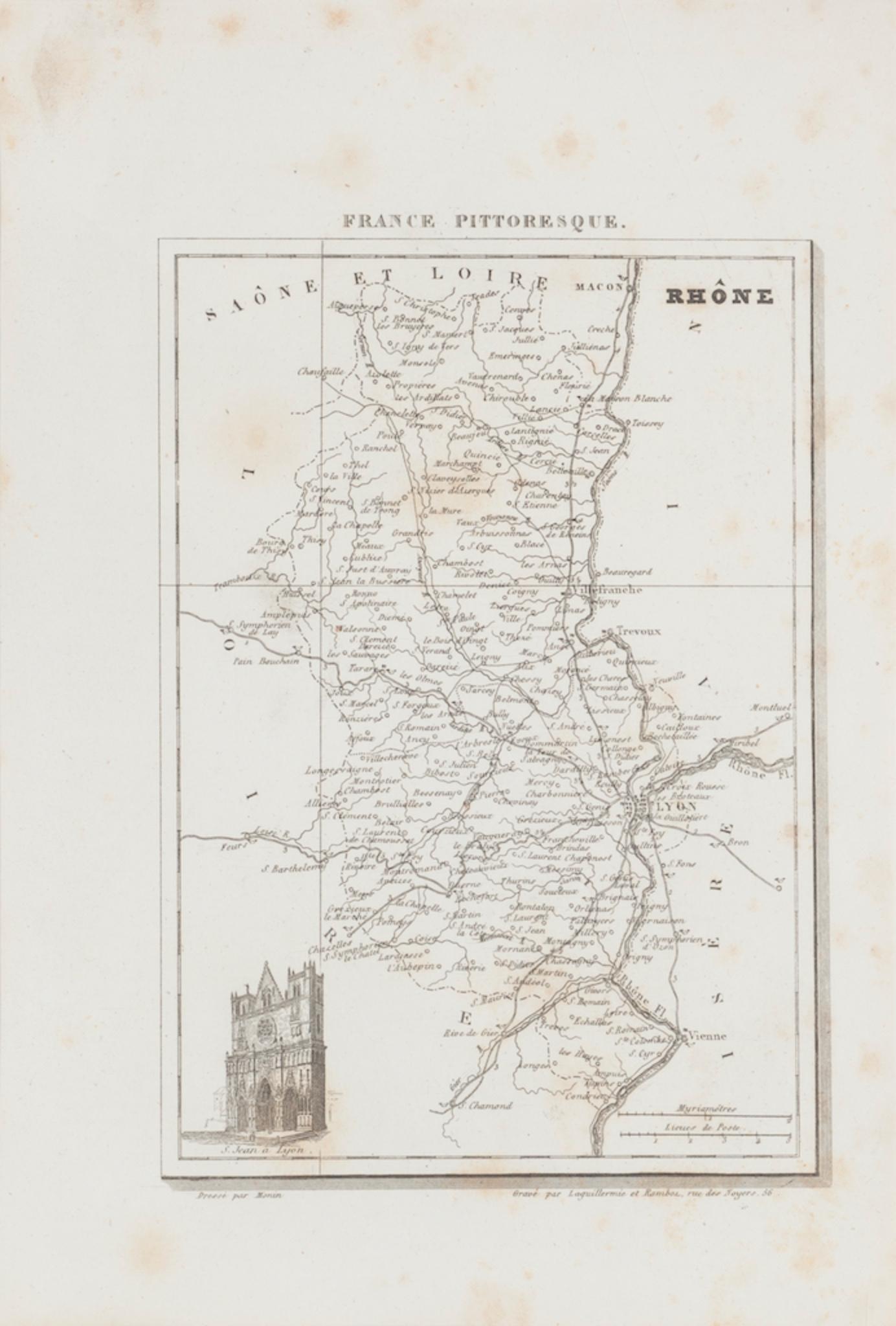
Map of Rhône - Original Etching - 19th Century
Located in Roma, IT
Map of Rhône is an original antique etching realized by an anonymous engraver of the 19th Century.
Printed in series of "France Pittoresque" at the top center.
The state of preserv...
Category
19th Century Modern Figurative Prints
Materials
Etching

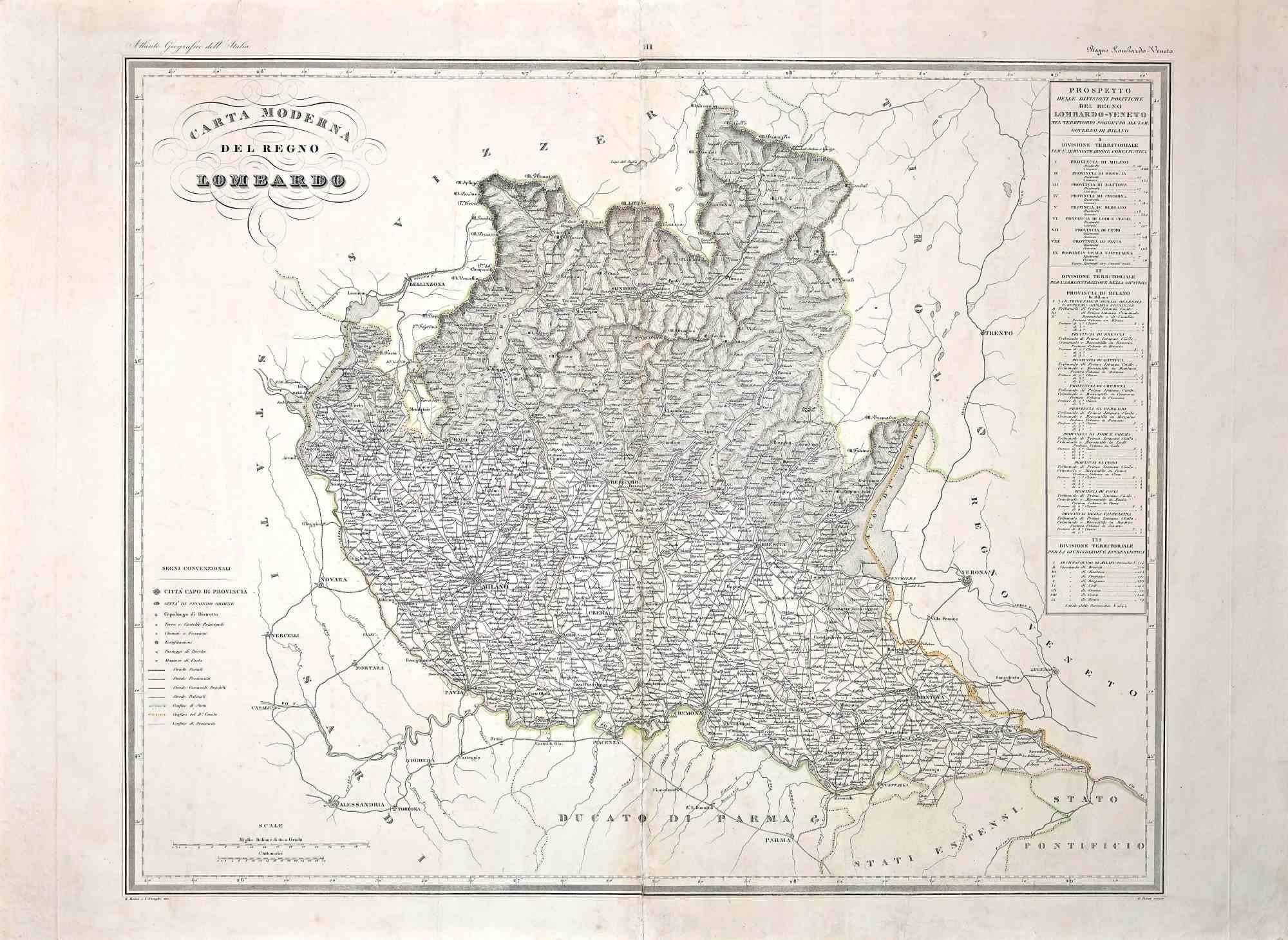
Map of Lombardy - Original Etching - 19th Century
Located in Roma, IT
The Map of Lombardy is an original etching realized by an anonymous artist.
Fair conditions, the folding line of the middle is repaired.
The artwork represents the map of Lombardo....
Category
19th Century Modern Figurative Prints
Materials
Etching
Map of France - Etching - 1820
Located in Roma, IT
Map of France is an Original Etching realized by an unknown artist of 19th century in 1820.
Very good condition on two sheets of white paper joined at t...
Category
1820s Modern Figurative Prints
Materials
Etching

Map of Campaign of 1814 - Etching by Pierre François Tardieu - 1837
Located in Roma, IT
Map of Campaign of 1814 is an Etching realized by Pierre François Tardieu in 1837.
Good conditions.
The artwork is realized in a well-balanced composition. the artwork and belongs ...
Category
1830s Modern Figurative Prints
Materials
Lithograph

You May Also Like
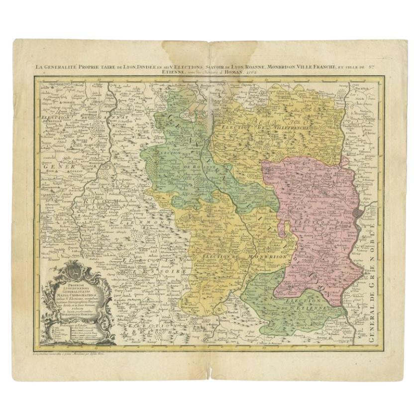
Antique Map of the Beaujolais Region by Homann Heirs, 1762
Located in Langweer, NL
Antique map titled 'La Generalite Proprie Taire De Lyon (..) - Propriae Lugudunensis Generalitatis (..)'. Detailed regional map of the Beaujolais region including the cities of Lyon,...
Category
Antique 18th Century Maps
Materials
Paper
Antique Map of ancient France by Zannoni, 1765
Located in Langweer, NL
Antique map France titled 'Galliae Veteris (..)'. Beautiful old map of France. This map originates from 'Atlas Historique de la France Ancienne et Moderne' ...
Category
Antique 18th Century Maps
Materials
Paper

Map of Oxfordshire coloured 18th century engraving by Thomas Kitchin
By Thomas Kitchin
Located in London, GB
To see our other original maps, scroll down to "More from this Seller" and below it click on "See all from this Seller" - or send us a message if you cannot find the poster you want....
Category
1760s Landscape Prints
Materials
Engraving

Antique Map of the Region of Lyonnais by Nolin, 1697
Located in Langweer, NL
Untitled map of the French Province of Lyonnais, with its capital at Lyon, on the upper Loire and Rhone rivers. This map is a single sheet and part of a two sheet map titled 'The Gen...
Category
Antique 17th Century Maps
Materials
Paper
Antique Map of France up-to the Peace of Ryswick by Zannoni, 1765
Located in Langweer, NL
Antique map France titled 'Carte pour servir à l'intelligence de l'Histoire de France (..)'. Beautiful old map of France. This map originates from 'Atlas Historique de la France Anci...
Category
Antique 18th Century Maps
Materials
Paper
Antique Map of the Region of Dauphiné by Zatta, 1779
Located in Langweer, NL
Antique map titled 'Li Governi del Delfinato e di Provenza la Contea Venaissin ed il Princie d'Orange'. Old map of France showing the province of Dauphiné. This map originates from '...
Category
Antique 18th Century Maps
Materials
Paper
More Ways To Browse
Etching Winter Scene
Faith Ringgold Quilts
Fay Lansner
Ferdinand Oscar Finne On Sale
Fragrance Of Park City
Frances Swigart
Francisco Goya The Prisoner
Frank Cassara
Fred Larson
Frederic Remington Lithographs
Frederic Vidalens
Fritz Eichenberg. On Sale
Fudo Myoo
Fuller Potter
G Hoffman
Gaetano Dura On Sale
George Grosz On Sale
George Jo Mess