Items Similar to View of Maastricht, The Netherlands -by G. Braun and F. Hogenberg - 16th Century

Want more images or videos?
Request additional images or videos from the seller
1 of 5
Georg Braun, Franz HogengergView of Maastricht, The Netherlands -by G. Braun and F. Hogenberg - 16th Century16th Century
16th Century
$521.64
£396.38
€440
CA$732.04
A$798.23
CHF 414.88
MX$9,555.82
NOK 5,262.31
SEK 4,929.14
DKK 3,351.96
About the Item
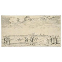
Map Traiectvm ad Mosam is original etching realized by Georg Braun and Franz Hogengerg between the end of the 16th and the first years of the 17th Century.
Dimension: 40 x 54
The state of preservation is good except for the line of folding in the middle which is repaired and the artwork is aged.
- Creator:Georg Braun, Franz Hogengerg
- Creation Year:16th Century
- Dimensions:Height: 15.75 in (40 cm)Width: 21.26 in (54 cm)Depth: 0.04 in (1 mm)
- Medium:
- Period:
- Framing:Framing Options Available
- Condition:Insurance may be requested by customers as additional service, contact us for more information.
- Gallery Location:Roma, IT
- Reference Number:Seller: M-1136651stDibs: LU65037382962
About the Seller
4.9
Platinum Seller
Premium sellers with a 4.7+ rating and 24-hour response times
1stDibs seller since 2017
7,810 sales on 1stDibs
Typical response time: 1 hour
- ShippingRetrieving quote...Shipping from: Roma, Italy
- Return Policy
More From This Seller
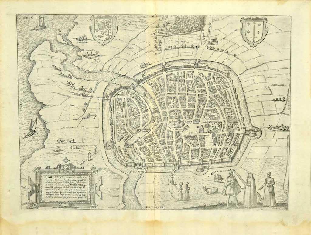
View AllView of Haarlem, The Netherlands - by G. Braun and F. Hogenberg - Late 1500
By Franz Hogenberg
Located in Roma, IT
This vie of Haarlem in the Netherlands (ancient name: Harlemvm) is an original etching realized by George Braun and Franz Hogenberg as part of the Series "Civitates Orbis Terrarum".
...
Category
16th Century Figurative Prints
Materials
Etching
View of Middelburg - Etching by G. Braun and F. Hogenberg - Late 1500
By Franz Hogenberg
Located in Roma, IT
This map of Middelburg (ancient name: Middelbvrgvm) is an original etching realized by George Braun and Franz Hogenberg as part of the famous Series "Civitates Orbis Terrarum".
The ...
Category
16th Century Figurative Prints
Materials
Etching
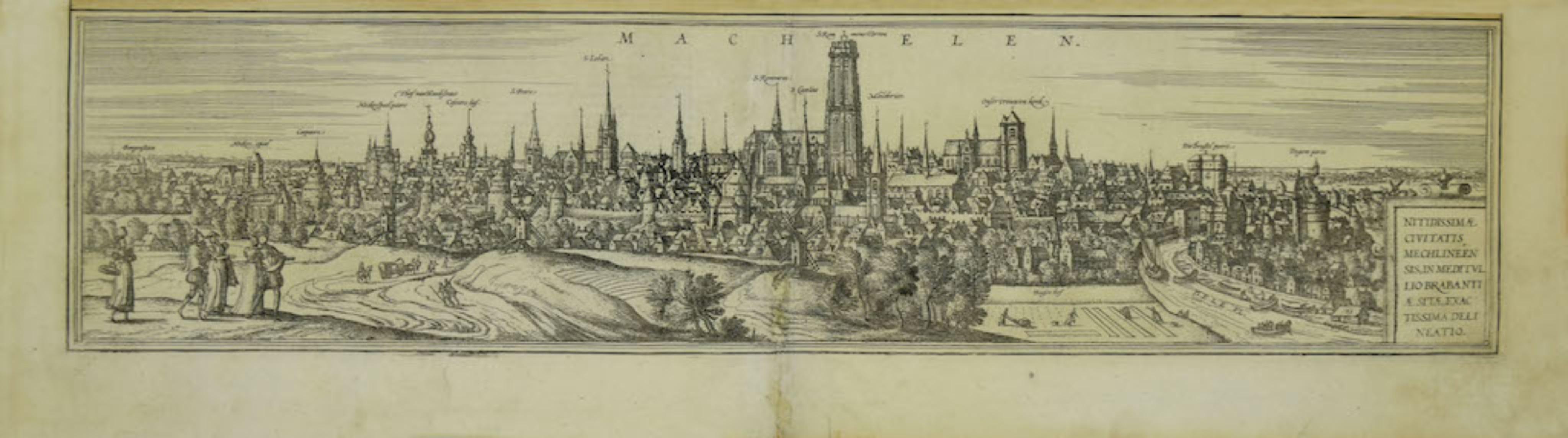
View of Mechelen - Original Etching by G. Braun and F. Hogenberg - 16th Century
By Franz Hogenberg
Located in Roma, IT
This Mechelen is an original etching realized by George Braun and Franz Hogenberg, as part of the famous "Civitates Orbis Terrarum".
The “Civitates Orbis Terrarum” (Atlas of Cities ...
Category
16th Century Modern Figurative Prints
Materials
Etching
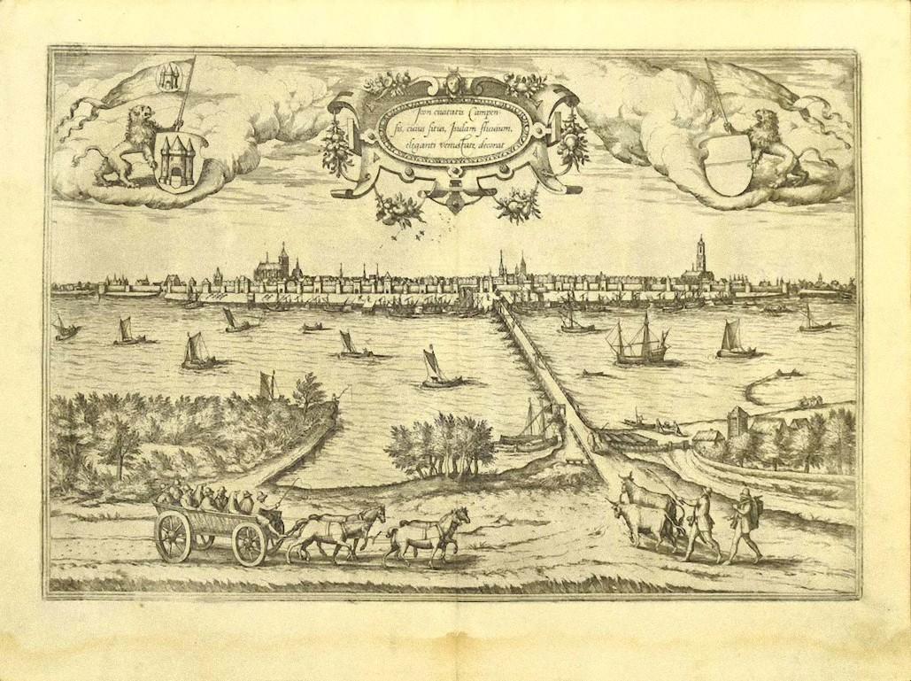
Map of Kampen, Netherlands - by G. Braun and F. Hogenberg - Late 16th Century
By Franz Hogenberg
Located in Roma, IT
This map of Kampen (the ancient Campensis) is an original etching realized by George Braun and Franz Hogenberg as part of the famous Series "Civitates Orbis Terrarum".
The “Civita...
Category
16th Century Figurative Prints
Materials
Etching

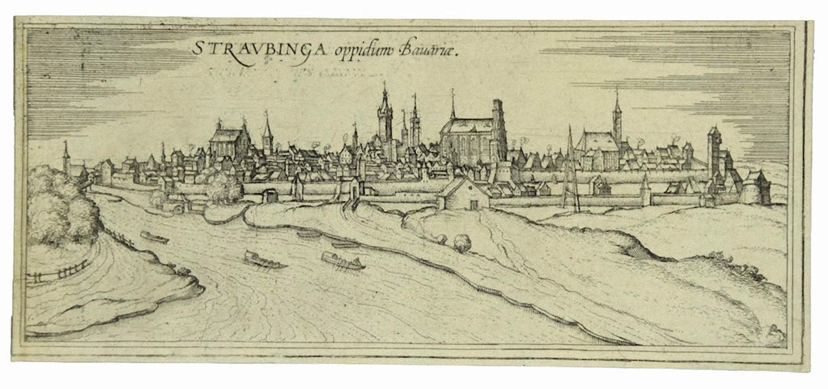
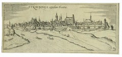
View of Straubing - Etching by G. Braun and F. Hogenberg - Late 16th Century
By Franz Hogenberg
Located in Roma, IT
The View of Strubing (ancient nam: Stravbinca) is an original etching realized by George Braun and Franz Hogenberg, as part of the "Civitates Orbis Terrarum"
The “Civitates Orbis Te...
Category
16th Century Figurative Prints
Materials
Etching
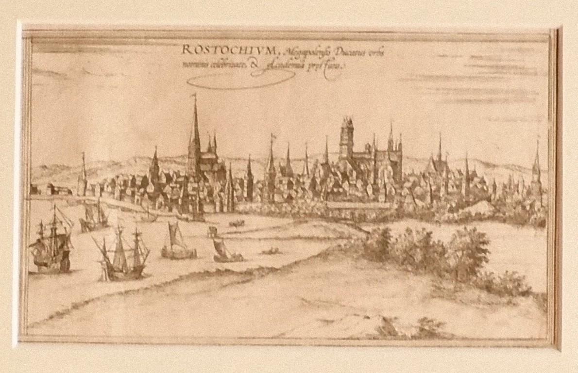
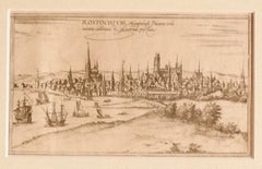
View of Rostock - Etching by G. Braun and F. Hogenberg - 16th Century
By Franz Hogenberg
Located in Roma, IT
The Map of Rostock (ancient name: Rostochivm) is an original etching realized by George Braun (1541 – 1622)
The state of preservation of the artwork is good but aged .
Sheet dimen...
Category
16th Century Figurative Prints
Materials
Etching
You May Also Like
View of Meissen, Germany: A 16th Century Hand-colored Map by Braun & Hogenberg
By Franz Hogenberg
Located in Alamo, CA
This is a 16th century original hand-colored copperplate engraved map of View of View of Meissen, Germany entitled "Misena Hermun Duvorum Urbs" by Georg Braun & Franz Hogenberg, from their famous city atlas "Civitates Orbis Terrarum", published in Cologne, Germany in 1575.
The map depicts a side view and bird's-eye view, looking across the Elbe River (labelled Albis Fluvius on the map; White River in Latin) from the northeast. In the foreground are three women in conversation on a hill above the city, along with a man and a woman in conversation by a road, all dressed in contemporary costumes of the upper class. A coat-of-arms is present in each upper corner. A great castle sits atop a hill in the background on the left. Meissen grew up around Albrechtsburg castle, built by Emperor Henry I around AD 929, and was granted a municipal charter at the end of the 12th century. From 1471 onwards, the castle complex was reconstructed as the residence of the Saxon electors on the northeast corner of the Domberg (Cathedral Hill). Meissen cathedral is a Gothic hall church begun c. 1270; in 1413 a bolt of lightning destroyed its west towers, which were replaced only in the 20th century. Meissen lies to the northwest of Dresden, Germany in Saxony. Meissen is famous for its Meissen porcelain and the Albrechtsburg castle
The following is an English translation of an excerpt from Braun's description of the city: "This city is surrounded by very many rivers, to the east flows the Elbe, to the south the Triebisch, to the west are the mountains, to the north the Meisse, after which the city is said to be named. The city is well-situated in its surroundings, the navigable rivers, the mountains and the healthy air. Around the city there is a good land to grow grain, fertile vineyards on the hillsides and without doubt the mountains are not without ore, for one mile away, up the Elbe, is Scharfenberg, where silver and lead ore are mined.."
References: Van der Krogt 4, 2684; Taschen, Braun and Hogenberg...
Category
16th Century Old Masters Landscape Prints
Materials
Engraving

Limburg Cityscape 1580: Historical Copper Engraving by Braun and Hogenberg
Located in Langweer, NL
Title: Limburgum Oppidum Galliae Belgicae, vulgo Lympurch, gallicè, Lembor Dr.
Type: Print (Copper Engraving)
Circa 1580
Technique: Colored Copper Engraving
Medium: Handmade Paper
S...
Category
Antique 16th Century German Maps
Materials
Paper

View of Cambridge, engraving Pieter van der Aa after David Loggan
By Pieter Van Der Aa
Located in London, GB
Pieter van der Aa (1659 - 1733), after David Loggan (1634 - 1692)
View of Cambridge
Engraving
12 x 16 cm
An eighteenth-century view of Cambridge, engraved by Pieter van der Aa after...
Category
Early 18th Century Realist Prints and Multiples
Materials
Engraving
View of Emden, Germany: A 16th Century Hand-colored Map by Braun & Hogenberg
By Franz Hogenberg
Located in Alamo, CA
This is a 16th century original hand-colored copperplate engraved map of a bird's-eye View of Embden, Germany entitled " Emuda, vulgo Embden vrbs Frisia orientalis primaria" by Georg Braun & Franz Hogenberg, in volume II of their famous city atlas "Civitates Orbis Terrarum", published in Cologne, Germany in 1575.
This is a beautifully colored and detailed map of Emden, a seaport in northwestern Germany, along the Ems River and perhaps portions of over Dollart Bay, near the border with the Netherland. The map depicts a bird's-eye view of the city from the southwest, as well as a view of the harbor and an extensive system of canals. Numerous ships of various sizes, as well as two rowboats containing numerous occupants are seen in the main waterway in the foreground and additional boats line two canals in the center of the city. Two men and two women are shown on a hill in the foreground on the right, dressed in the 16th century style of nobility. Two ornate crests are included in each corner. A title strap-work cartouche is in the upper center with the title in Latin. The crest on the right including Engelke up de Muer (The Little Angel on the Wall) was granted by Emperor Maximilian I in 1495.
This is an English translation of an excerpt of Braun's description of Embden: "In Emden, the capital of East Frisia, rich merchants live in very fine houses. The city has a broad and well-situated harbour, which in my opinion is unique in Holland. Frisia and the whole of the Netherlands, for the ships can anchor here right under the city walls. They have also extended the harbour as far as the New Town, so that up to 400 ships can now find shelter here when the sea is rough."
The emphasis on the harbor and waterways within the city highlights the importance of Emden's place as a seaport at this time. Embden developed from a Dutch/Flemish trading settlement in the 7th-8th centuries into a city as late as late 14th century. In 1494 it was granted staple rights, and in 1536 the harbour was extended. In the mid-16th century Emden's port was thought to have the most ships in Europe. Its population then was about 5,000, rising to 15,000 by the end of the 16th century. The Ems River flowed directly under the city walls, but its course was changed in the 17th century by the construction of a canal. Emden has canals within its city limits, a typical feature of Dutch towns, which also enabled the extension of the harbor. In 1744 Emden was annexed by Prussia and is now part of Germany. It was captured by French forces in 1757 during the Seven Years' War, but recaptured by Anglo-German forces in 1758. During the Napoleonic French era, Emden and the surrounding lands of East Frisia were part of the short-lived Kingdom of Holland.
References:Van der Krogt 4, 1230, State 2; Taschen, Braun and Hogenberg...
Category
16th Century Old Masters Landscape Prints
Materials
Engraving

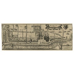
Original Old & Rare View of the City of Workum, Friesland, The Netherlands, 1616
Located in Langweer, NL
Antique map titled 'Worcum'. This print depicts the city of Workum (Friesland, The Netherlands). With German captions. This print originates from 'Rerum Frisicarum Historia' publishe...
Category
Antique 1610s Maps
Materials
Paper
$398 Sale Price
20% Off
Original Antique Engraving of the City of Franeker in The Netherlands, 'c.1598'
Located in Langweer, NL
Antique print titled 'Franeker'. Extremely rare view on the city of Franeker, Friesland, the Netherlands. Published circa 1598 by P. Bast.
Artists and Engravers: Pieter Bast (ca 1...
Category
Antique 16th Century Prints
Materials
Paper
$938 Sale Price
20% Off