Items Similar to Plan of Port Siagi - Etching by Joseph Roux - 1795

Want more images or videos?
Request additional images or videos from the seller
1 of 3
UnknownPlan of Port Siagi - Etching by Joseph Roux - 17951795
1795
$359.02
£268.77
€300
CA$494.24
A$540.30
CHF 285.84
MX$6,465.54
NOK 3,636.93
SEK 3,329.24
DKK 2,285.63
About the Item
Plan of Port Siagi is al colored etching realized by Joseph Roux in 1795.
The title at the top " Plan du Port Siagi"
Passepartout included: 34 x 49
The artwork is hand water-colored and represents the greek port.
- Creation Year:1795
- Dimensions:Height: 6.11 in (15.5 cm)Width: 8.67 in (22 cm)Depth: 0.08 in (2 mm)
- Medium:
- Movement & Style:
- Period:1790-1799
- Framing:Framing Options Available
- Condition:Insurance may be requested by customers as additional service, contact us for more information.
- Gallery Location:Roma, IT
- Reference Number:Seller: M-1181361stDibs: LU65037981682
About the Seller
4.9
Platinum Seller
Premium sellers with a 4.7+ rating and 24-hour response times
1stDibs seller since 2017
7,852 sales on 1stDibs
Typical response time: 1 hour
- ShippingRetrieving quote...Shipping from: Grasse, France
- Return Policy
More From This Seller
View AllMap of Nubia and Abissinia - Original Etching by Antonio Zatta - 1784
Located in Roma, IT
This Map of Nubia and Abissinia is an etching realized by Antonio Zatta in Venice in 1784.
The state of preservation of the artwork is good expect for the worn paper with some littl...
Category
1770s Landscape Prints
Materials
Etching

Map - Etching by Nicola Fiorillo - 18th Century
Located in Roma, IT
Map from "Antiquities of Herculaneum" is an etching on paper realized by Nicola Fiorillo in the 18th Century.
Signed on the plate.
Good conditions with some folding and foxing.
Th...
Category
18th Century Old Masters Figurative Prints
Materials
Etching
Carte Pour Servir a l'Histoire Philosophique.. - Etching by Rigobert Bonne- 1780
Located in Roma, IT
Etching on paper.
From Guillaume-Thomas Raynal, Histoire philosophique et politique des établissemens et du commerce des Européens dans les deux Indes, Geneva 1780.
This interestin...
Category
1780s Modern Figurative Prints
Materials
Etching
Dalmatia with the Adjacent Islands - Etching by Giovanni Cassini - 1792
Located in Roma, IT
Dalmatia with the Adjacent Islands - Plate 42 is an original old master artwork realized by Giovanni Cassini in 1792
Handcolored etching.
Includes frame
Category
Late 18th Century Old Masters Figurative Prints
Materials
Etching
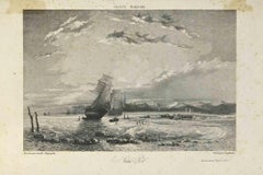
France Maritime - Lithograph by Camille Roqueplan - 19th century
Located in Roma, IT
France Maritime is an original print on paper realized by Camille Roqueplan in the mid-19th Century.
Signed on the plate and titled.
engraving.
Good conditions, with foxing.
Category
19th Century Modern Figurative Prints
Materials
Lithograph
Map of Greece - Original Etching by Antonio Zatta - 18th Century
Located in Roma, IT
This Map of Greece is an etching realized by Antonio Zatta, Cartographer, publisher and typographer.
The state of preservation of the artwork is good except for the worn paper and t...
Category
1780s Figurative Prints
Materials
Etching

You May Also Like
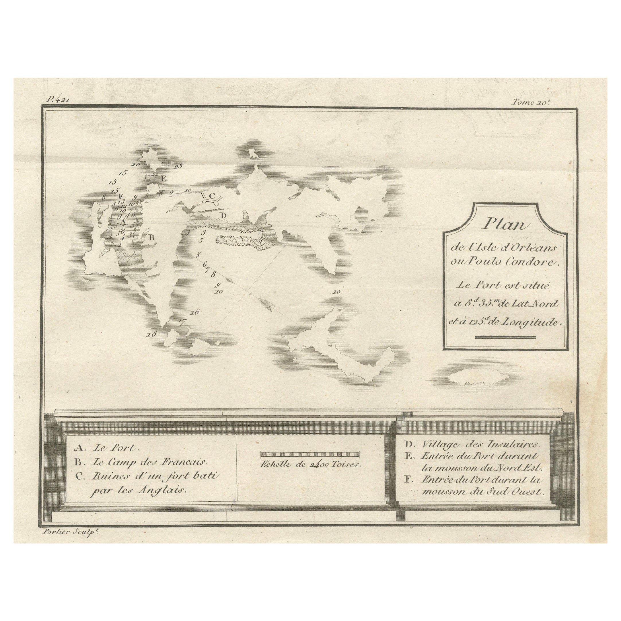
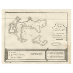
Plan of Poulo Condore (Côn Sơn Island) – Antique French Engraving, ca.1790
Located in Langweer, NL
Plan of Poulo Condore (Côn Sơn Island) – Antique French Engraving by Portier, c.1790
This antique French engraving, created by Portier around 1790, presents a detailed plan of Poulo...
Category
Antique Late 18th Century French Maps
Materials
Paper
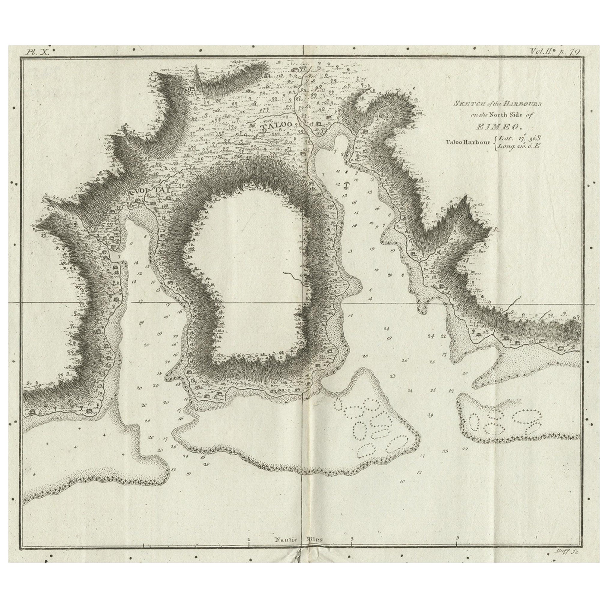
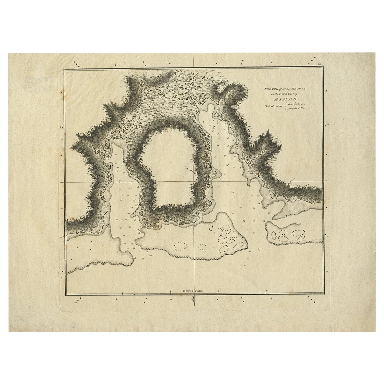
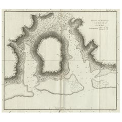
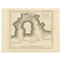
Antique Plan of the Harbour of Taloo by Cook, c.1781
Located in Langweer, NL
Antique map titled 'Sketch of the Harbours on the North Side of Eimeo (..)'. Plan of the harbour of Taloo in the Island of Moorea, one of the Society Islands, French Polynesia. Origi...
Category
Antique 18th Century Maps
Materials
Paper
$220 Sale Price
20% Off
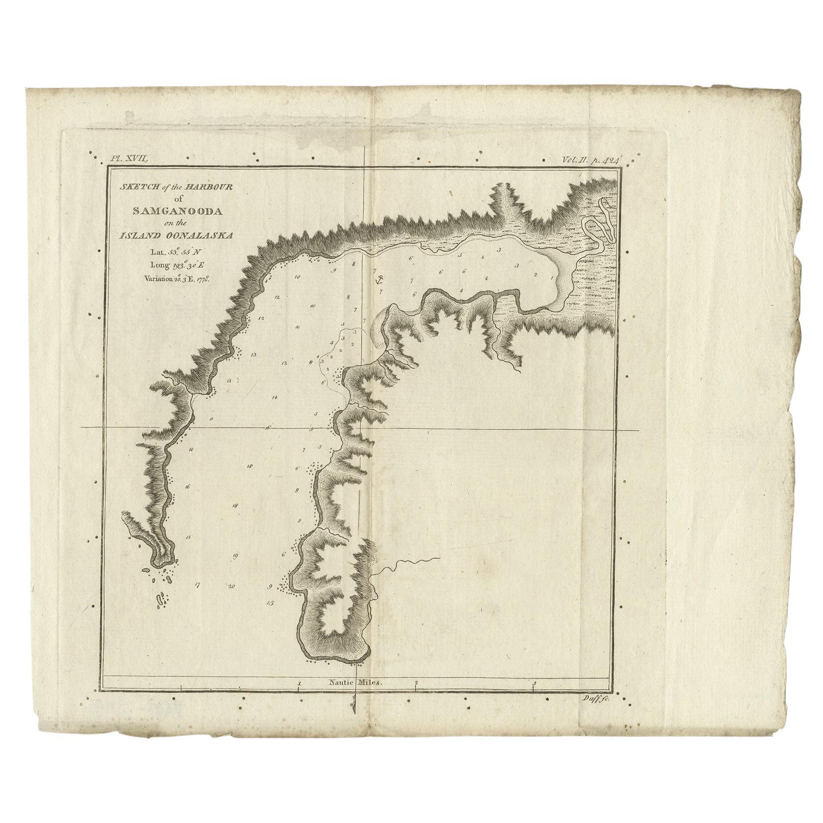
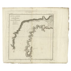
Antique Map of the Harbour of Samganoodha by Cook, c.1781
Located in Langweer, NL
Antique map titled 'Sketch of the Harbour of Samganooda (..)'. Antique map of the Harbour of Samganoodha, Oonalaska, North America. Originates from an edition of Cook's Voyages.
Art...
Category
Antique 18th Century Maps
Materials
Paper
Antique Plan of the Harbour of Taloo by Cook, 1784
Located in Langweer, NL
Antique map titled 'Sketch of the Harbours on the North Side of Eimeo (..)'. Plan of the harbour of Taloo in the Island of Moorea, one of the Society Islands, French Polynesia. Origi...
Category
Antique 18th Century Maps
Materials
Paper
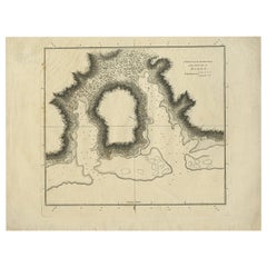
$181 Sale Price
20% Off
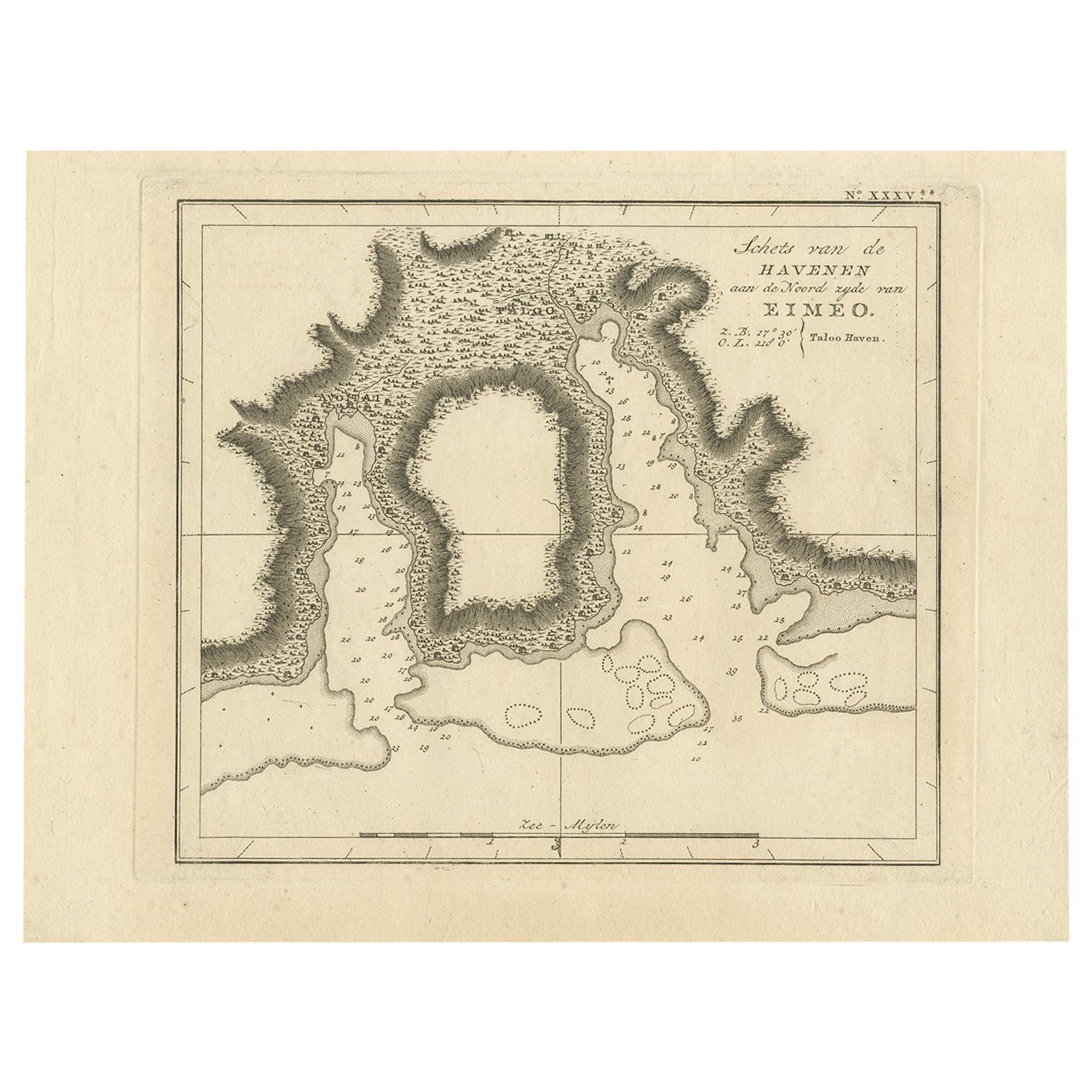
Antique Map of the Harbour of Taloo by J. Cook, 1803
By James Cook
Located in Langweer, NL
Antique map French Polynesia titled 'Schets van de Havenen aan de Noord Zijde van Eimeo'. Plan of the harbour of Taloo in the Island of Moorea, one of the Society Islands, French Polynesia. Originates from 'Reize rondom de Waereld door James Cook...
Category
Antique Early 19th Century Dutch Maps
Materials
Paper
Original Antique Map of the Harbour of Tongatabu by Cook, 1784
Located in Langweer, NL
Antique map titled 'Sketch of Tongataboo Harbour (..)'. Antique map of the harbour of Tongatabu, one of the Tonga Islands. Originates from an edition of Cook's Voyages.
Artists an...
Category
Antique 18th Century Maps
Materials
Paper

$421 Sale Price
20% Off
More Ways To Browse
Pablo Picasso Raphael Et La Fornarina
Paradise 20 Dali
Parasol Howard Behrens
Patrick Nagel On Sale
Paul Iribe On Sale
Pegge Hopper
Penal Cross
Peter Doig Zermatt
Peter Forster
Peter Max 9 11
Peter Max Earth Day
Peter Max Friends
Peter Max Ladies
Peter Max World Cup
Peter Wever On Sale
Phyllis Lucas Gallery Old Print Center
Picasso 156 Series Etchings
Picasso 1970 100