Items Similar to Edinburgh, Scotland: An Original 17th C. Hand-Colored Engraved Sea Chart

Want more images or videos?
Request additional images or videos from the seller
1 of 9
Captain Greenvile CollinsEdinburgh, Scotland: An Original 17th C. Hand-Colored Engraved Sea Chart1693
1693
$2,775
£2,100.08
€2,412.05
CA$3,946.18
A$4,278.48
CHF 2,254.75
MX$52,030.45
NOK 28,052.65
SEK 26,528.40
DKK 18,007.29
About the Item
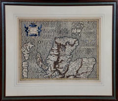
This hand-colored sea chart is entitled "Edinburgh Firth" from "Great Britain's Coasting Pilot. Being a New and Exact Survey of the Sea-Coast of England" by Captain Greenville Collins, first published in 1693. It depicts the city of Edinburgh, Scotland with its castle and abbey and adjacent waterways, as well as St. Andrews and Dunbar, Scotland. It includes a compass rose, a sailing ship and multiple rhumb lines, as well as depth markings along the coast. The beautiful and colorful cartouche is enhanced by multiple spears, guns, cannons, flags, sea birds, fish, two mermaids, a coat of arms and a crown. It includes a dedication to James Earle of Perth, Lord Chancellor of Scotland.
These sea charts by Captain Greenvile Collins (1643-1694) are beautiful, colorful and striking, as well as historically very important to the British navy for approximately 100 years. Captain Collins was appointed “His Majesty’s Hydrographer” by King Charles II and asked to survey the coast of Great Britain and plot all of the harbors, rivers and islands, etc. This took seven years and the resulting charts were first published in 1693. They were published until 1792.
We have 16 sea charts from this series that are all the same size and are framed and matted identically. The frames are a unique plexiglass sleeve design, measuring: 23" x 27.75" x 0.5" and the mats are a cream color. There is a horizontal fold, a vertical crease on the right and tiny spots in the upper chart. It is otherwise in excellent condition.
The provenance for these sea charts is very interesting. They were owned by Tom Perkins, who is considered one of the fathers of Silicon Valley. He was one of the founders of Kleiner Perkins Cauffield and Byers, the first big and most influential Silicon Valley venture capital company. Perkins himself was an avid sailor and had at the time the largest and most technologically advanced sailing yacht in the world, the Maltese Falcon.
- Creator:Captain Greenvile Collins (1643 - 1694, British)
- Creation Year:1693
- Dimensions:Height: 23 in (58.42 cm)Width: 27.75 in (70.49 cm)Depth: 0.5 in (1.27 cm)
- Medium:
- Period:Late 17th Century
- Condition:
- Gallery Location:Alamo, CA
- Reference Number:Seller: # 32401stDibs: LU117326647642
About the Seller
5.0
Platinum Seller
Premium sellers with a 4.7+ rating and 24-hour response times
Established in 2011
1stDibs seller since 2019
293 sales on 1stDibs
Typical response time: 1 hour
- ShippingRetrieving quote...Shipping from: Alamo, CA
- Return Policy
Authenticity Guarantee
In the unlikely event there’s an issue with an item’s authenticity, contact us within 1 year for a full refund. DetailsMoney-Back Guarantee
If your item is not as described, is damaged in transit, or does not arrive, contact us within 7 days for a full refund. Details24-Hour Cancellation
You have a 24-hour grace period in which to reconsider your purchase, with no questions asked.Vetted Professional Sellers
Our world-class sellers must adhere to strict standards for service and quality, maintaining the integrity of our listings.Price-Match Guarantee
If you find that a seller listed the same item for a lower price elsewhere, we’ll match it.Trusted Global Delivery
Our best-in-class carrier network provides specialized shipping options worldwide, including custom delivery.More From This Seller
View AllNorthern Scotland: 17th Century Hand-colored Map by Mercator
By Gerard Mercator
Located in Alamo, CA
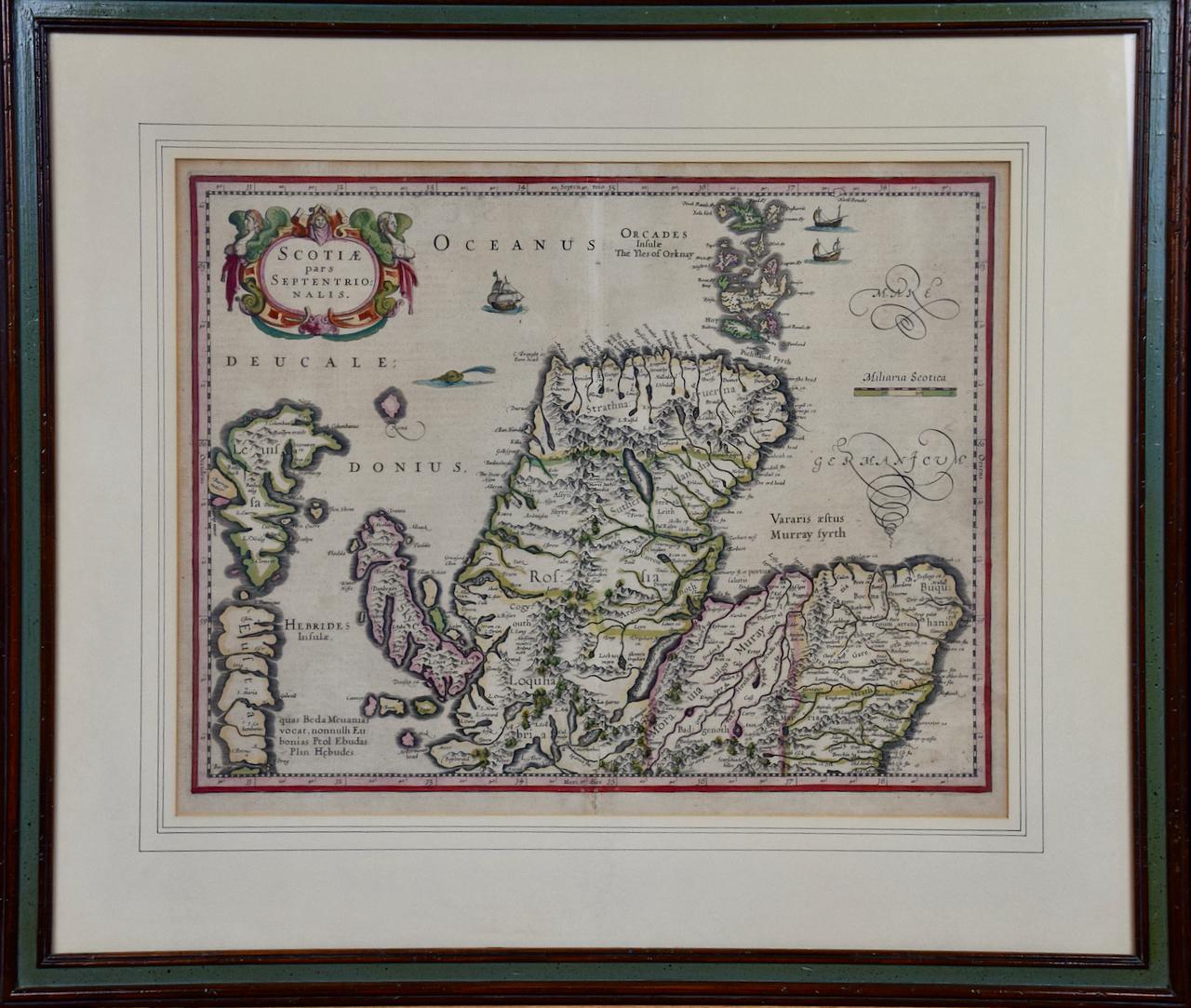
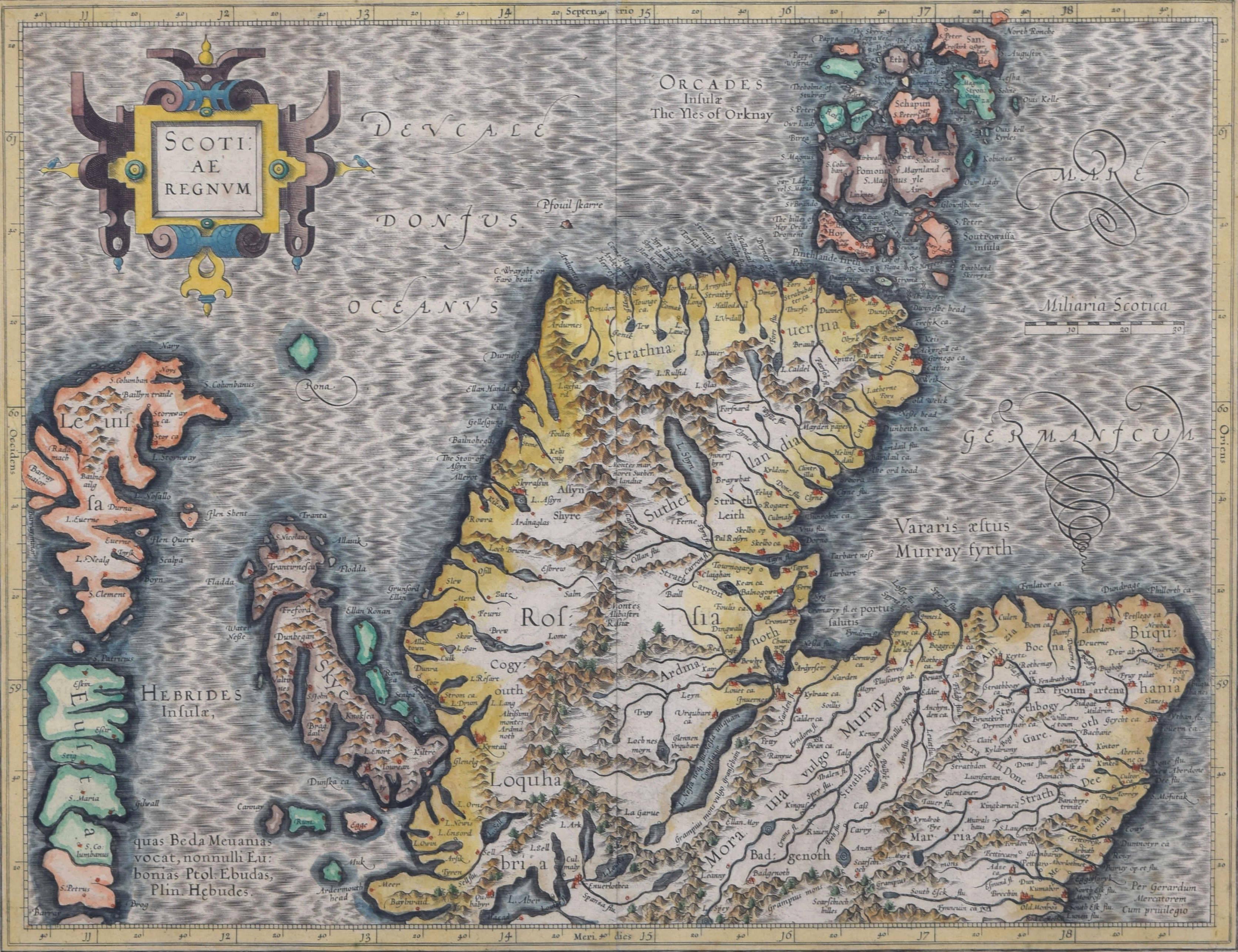
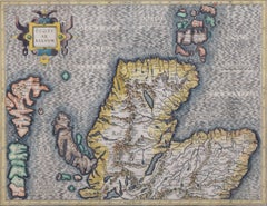
This is a framed hand-colored 17th century map of Northern Scotland by Gerard Mercator entitled "Scotiae pars Septentrionalis", published in Amsterdam in 1636. It is a highly detailed map of the northern part of Scotland, with the northwest Highlands and the cities Inverness and Aberdeen, as well as the Orkney Islands and the Hebrides. There is a decorative title cartouche in the upper left corner.
The map is presented in an antiqued brown wood...
Category
Mid-17th Century Other Art Style Landscape Prints
Materials
Engraving

Northern Scotland: 16th Century Hand-colored Map by Mercator
By Gerard Mercator
Located in Alamo, CA
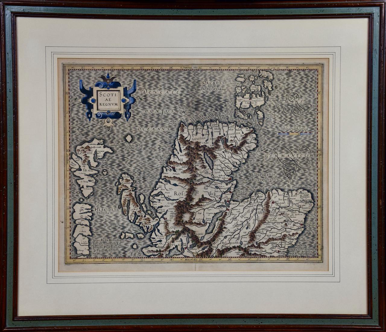
This is a framed hand-colored 16th century map of Northern Scotland by Gerard Mercator entitled "Scotiae pars Septentrionalis", published in Amsterdam in 1636. It is a highly detailed map of the northern part of Scotland, with the northwest Highlands and the cities Inverness and Aberdeen, as well as the Orkney Islands and the Hebrides. There is a decorative title cartouche in the upper left corner.
The map is presented in an antiqued brown wood...
Category
16th Century Other Art Style Landscape Prints
Materials
Engraving
Cadiz Island: A Framed 17th Century Hand-colored Map from Blaeu's Atlas Major
By Joan (Johannes) Blaeu
Located in Alamo, CA
This is a 17th century hand-colored map entitled "Insula Gaditana Isla de Cadiz" from Johannes (Joan) Blaeu's Atlas Maior, published in Amsterdam in 1662.
The map provides an excellent plan of Cadiz Island on the southwest coast of Spain, with its harbor, fortifications, agricultural fields and several surrounding salt processing areas. Numerous sailing ships of various sizes are included in and around the harbor and bay, including five large sailing ships, as well as twenty-four smaller ships. There is a small compass rose overlying the bay. The bridge to the mainland from the island is shown on the right. There is an extremely ornate and colorful title cartouche in the lower left, with its mythological figures reminiscent of Raphael’s Galatea fresco at the Villa Farnesina in Rome. The vibrant colors are vividly preserved. The master colorist tried to emulate a painting by using various tones to create a three-dimensional effect.
Blaeu's name is present in the plate in the lower right. Blaeu stated in his description of Cadiz: “The main wealth of the islanders consists of salt, which they harvest, and
the tuna fisheries.”
This 17th century hand-colored map is framed in an ornate, partially textured bronze-colored wood frame and glazed with UV protected conservation glass. There is a vertical center fold, as issued. There is a faint crease in the lower right and faint color offset on the left from the right side of the map, resulting from having been in an atlas for hundreds of years. Small foci of paint are present in the upper portion of the left margin and in the left corner margin. The map is otherwise in very good condition.
Due in large part to their powerful trade empire, the Dutch became known for cartography in the seventeenth century. This period is considered the Golden Age of Dutch cartography. Their publishing houses produced the highest quality work in Europe, particularly those maps and charts of foreign lands, and Dutch map-making set the bar for cartographic accuracy and artistry into the early-eighteenth century. Some of the most well-known cartographers worked in Amsterdam during this period. Perhaps the most famous of these was the Blaeu family. Willem Janszoon Blaeu, set up shop in Amsterdam. His son, Johannes (Joan), succeeded him upon his death in 1638, continuing in his father’s position as Hydrographer to the Dutch East India Company and selling maps to the public. The Blaeu map presses, located near Amsterdam’s Dam Square...
Category
Mid-17th Century Old Masters Landscape Prints
Materials
Engraving

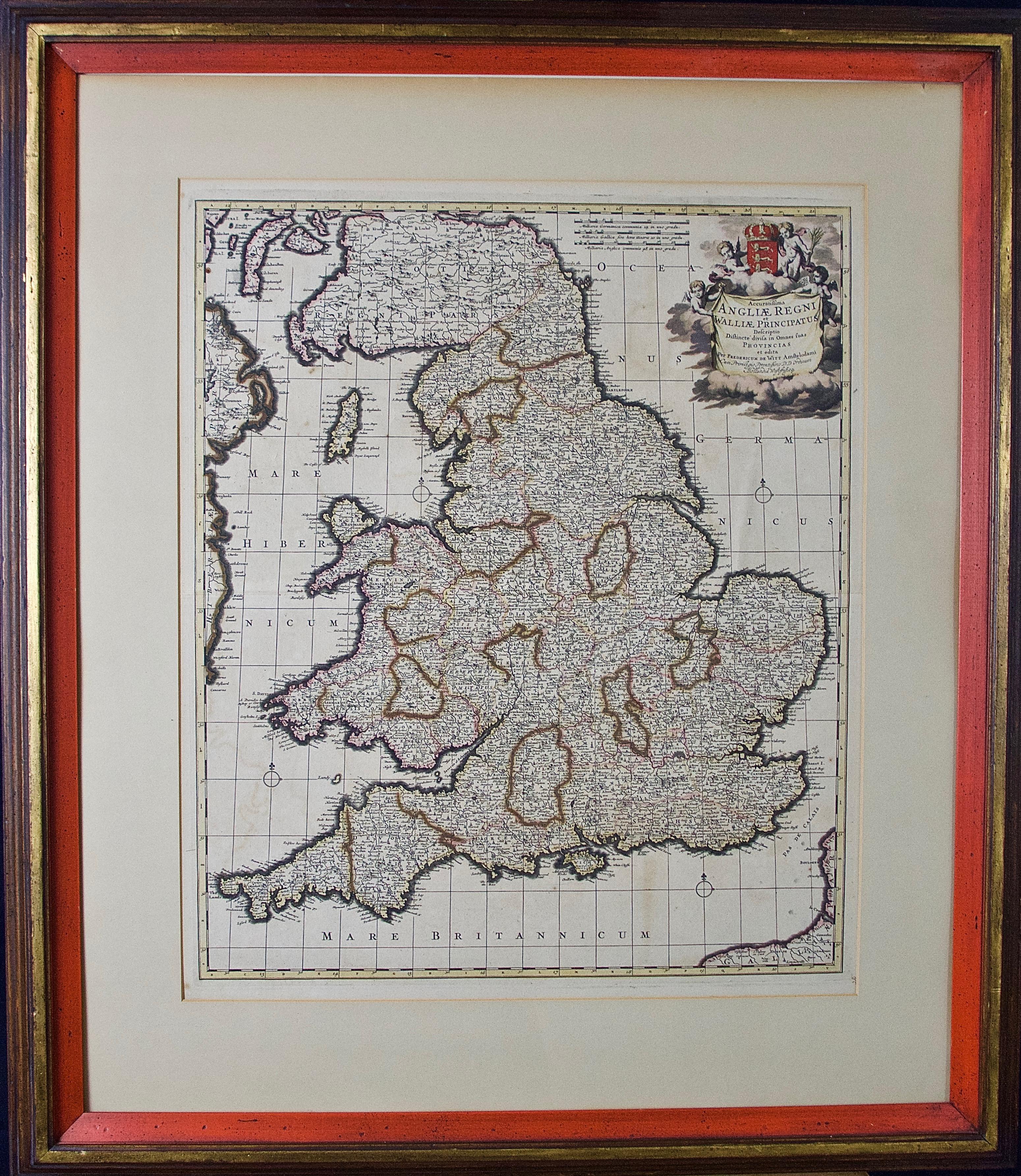
England and the British Isles: A Large 17th Century Hand-colored Map by de Wit
By Frederick de Wit
Located in Alamo, CA
This is a large hand-colored 17th century map of England and the British Isles by Frederick de Wit entitled "Accuratissima Angliæ Regni et Walliæ Principatus", published in Amsterdam in 1680. It is a highly detailed map of England, Scotland, the Scottish Isles...
Category
Late 17th Century Other Art Style Landscape Prints
Materials
Engraving

Mediterranean and Adriatic Seas: Original 18th Century Hand-colored Map by Bowen
Located in Alamo, CA
This is an original 18th century hand-colored map entitled "An Accurate Chart of The Mediterranean and Adriatic Sea's; with the Archipelago & Part of the Black Sea. Exhibiting all th...
Category
Mid-18th Century Old Masters Landscape Prints
Materials
Engraving

Southern Holland: An Original 17th C. Hand-colored Visscher Map "Hollandiae"
By Nicolaus Visscher
Located in Alamo, CA
This a beautiful framed hand colored 17th century map of the southern portions of Holland by Nicolaus (Nicolas) Visscher II entitled "Hollandiae pars Meridionalis, vulgo Zuyd-Holland", published in Amsterdam in 1678. The map shows the region between Breda, Heusden, Gornichem, Gouda, Dordrecht, and Willemstad. It includes a decorative cartouche in the lower left corner.
The map is presented in an attractive maple colored wood frame with gold trim and a fabric mat. There is a central vertical fold, as issued. There are small areas of discoloration consistent with age. The map is otherwise in very good condition.
The Visscher family were one of the great cartographic families of the 17th century. Begun by Claes Jansz Visscher...
Category
Late 17th Century Other Art Style Landscape Prints
Materials
Engraving

You May Also Like
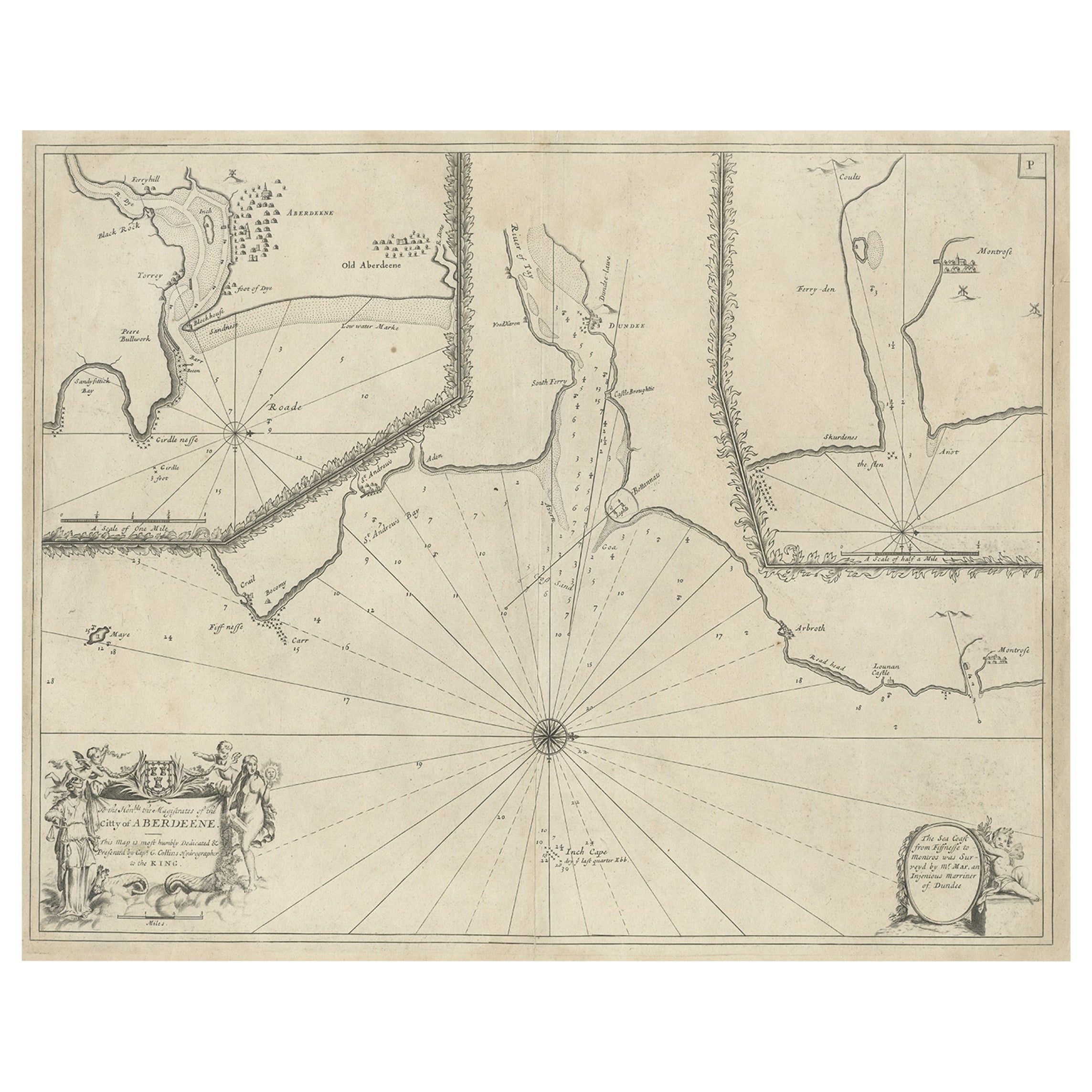
Antique Chart of Dundee, Aberdeen and Montrose in Scotland, C.1774
By Captain Greenvile Collins
Located in Langweer, NL
Antique map titled 'To the Honble the Magistrates of the Citty of Aberdeene'. Sea chart of Tay Estuary depictinging Dundee, with two further inset charts of Aberdeen and Montrose, wi...
Category
Antique 18th Century Maps
Materials
Paper
$258 Sale Price
20% Off
Map of the North of Scotland 17th century hand-coloured map by Gerardus Mercator
Located in London, GB
Gerardus Mercator (1512 - 1594)
Map of the North of Scotland (1683)
Engraving with later hand colouring
35 x 45 cm
A fantastically characterful and detailed map engraving of the North of Scotland from 1683. The highly detailed and beautifully coloured map is inscribed to the reverse with a description of the parts of Scotland illustrated, called the 'Troisieme Table d'Escosse'. The map comes from the 1683 French edition of Gerardus Mercator's Atlas Major, which was first published in 1585.
Gerardus Mercator was the Flemish father of mapmaking. He was a skilled geographer, cosmographer and cartographer and is most renowned for creating the 1569 world map based on a new projection which represented sailing courses of constant bearing (rhumb lines) as straight lines - an innovation that is still employed in today's nautical charts.
Mercator was a highly influential pioneer in the history of cartography and is generally considered one of the founders of the Netherlandish school of cartography and geography. He is also widely considered the most notable figure of the school. In his own day, he was a notable maker of globes and scientific instruments. In addition, he had interests in theology, philosophy, history, mathematics and geomagnetism. He was also an accomplished engraver and calligrapher. Unlike other great scholars of the age, he travelled little and his knowledge of geography came from his library of over a thousand books and maps, from his visitors and from his vast correspondence (in six languages) with other scholars, statesmen, travellers, merchants and seamen. Mercator's early maps were in large formats suitable for wall mounting but in the second half of his life, he produced over 100 new regional maps in a smaller format suitable for binding into his Atlas of 1595. This was the first appearance of the word Atlas in reference to a book of maps...
Category
1680s Prints and Multiples
Materials
Engraving
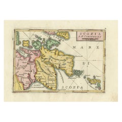
Scozia – Antique Map of Scotland by Coronelli, circa 1690
Located in Langweer, NL
Map of Scotland by Coronelli, c.1690 – “Scozia A.P. Coronelli”
This finely engraved and hand-colored map depicts Scotland, titled Scozia A.P. Coronelli, produced by the renowned Ven...
Category
Antique Late 17th Century Italian Prints
Materials
Paper
Antique Map of the Bay and Island of Arguin by Van Schley, 1747
Located in Langweer, NL
Antique map titled ?Plan de la Baye et Isle d'Arguim (..) - Oppervlakte van de Baai en 't Eiland van Arguin (..)'. Original antique map of the bay and the island of Arguin. This map ...
Category
Antique 18th Century Maps
Materials
Paper

$93 Sale Price
20% Off
Antique Map of Scotland by Cary, '1811'
Located in Langweer, NL
Antique map titled 'A New Map of Scotland from the Latest Authorities':
**Title**: A New Map of Scotland from the Latest Authorities
**Publisher**: J....
Category
Antique Early 19th Century Maps
Materials
Linen, Paper

$765 Sale Price
20% Off
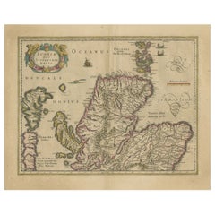
Original Antique Map of the Northern Part of Scotland, circa 1640
Located in Langweer, NL
The antique map, titled 'Scotiae pars septentrionalis,' depicts the northern part of Scotland. Crafted by Hondius around 1640, this map is a historical treasure showcasing the geogra...
Category
Antique Mid-17th Century Maps
Materials
Paper
$842 Sale Price
20% Off
More Ways To Browse
Antique Maltese
Antique Scottish Prints
Scotland Castles
Scottish Castle
Antique Perth
Original Comic Art
Pablo Picasso Bird
Picasso Terracotta
Rca Antique
Robert Moses
Saint George Sculpture
San Juan Capistrano
Sculpture Ceramique
The Blues Brothers
Used Sea Plane
Vintage Baby Portraits
Vintage Boxing Painting
Vintage Womens Pins