Items Similar to Daniel Marot's The Siege of the Dutch Fortified City of Ypres by Louis XIV

Want more images or videos?
Request additional images or videos from the seller
1 of 15
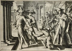
Daniel MarotDaniel Marot's The Siege of the Dutch Fortified City of Ypres by Louis XIV1680
1680
$1,275
£968.20
€1,109.09
CA$1,810.54
A$1,980.46
CHF 1,035.43
MX$23,855.18
NOK 12,941.48
SEK 12,208.47
DKK 8,279.23
About the Item
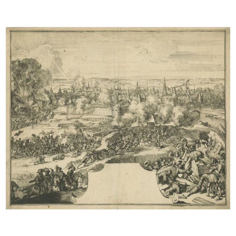
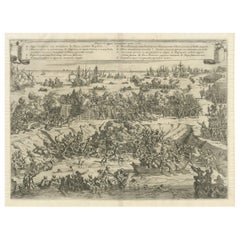
"Ypres, Grand Ville Riche & Marchande" is an engraving and etching by Daniel Marot (le Vieux) (1661–1752). It depicts a view of the siege of the city of Ypres and its citadel on the left in the Spanish Netherlands by Louis XIV's troops. This battle took place between March 18 and March 25, 1678, as part of the Franco-Dutch War. Marot illustrated in great detail (best appreciated with magnification) the French attack on the strong pentagonal citadel on the extreme left, which had been built recently in anticipation of a French attack. The trenches built by the French approaching the town are seen on the right. King Louis XIV can be seen in the foreground surveying the battle mounted on his white horse, surrounded by his officers and troops.
The print is presented in an attractive ornate black wood frame with a cream-colored double mat with a black inner trim. It is glazed with plexiglas. The frame measures 25.38" x 22.63" x .88". The engraving, frame, mat and glazing are in excellent condition.
Artist: Daniel Marot (1661–1752) was also called "Le Vieux". He was the son of the famous architect, Jean Marot. Marot had diverse interests and talents. In addition to his art, he designed garden projects, architectural ornaments, furniture, and even upholstery. Marot as a Huguenot protestant was forced to leave France in 1685 following the revocation of the Edict of Nantes. He emigrated to Holland, where he worked for William of Orange (an arch enemy of his former employer Louis XIV). Marot was largely responsible for the interiors of Williams palace at the Loo. In 1694 he went Britain as William had married Queen Mary and he had become King William III of England. He later returned to Holland in about 1698 and died in the Hague in 1752. He left a lasting legacy on the decorative arts in the Netherlands, where his grand version of the Louis XIV style remained popular into the 1730s.
Historical Background: In October 1677, Mary Stuart, niece and possible successor of Charles II of England, married Louis XIV's arch enemy William III of Orange. Louis decided to invade the Spanish Netherlands to counter a possible English military intervention against him. In one of his maneuvers of this military campaign, Louis deceived the Spanish into thinking that his target was Luxembourg or Namur, but instead advanced on Ypres. The Spanish and Dutch then redirected their troops from Ghent to Ypres to reinforce its defense. The French then suddenly turned on Ghent and the depleted garrison was quickly defeated. The Dutch and their allies the Spanish expected an attack against Namur or Luxembourg, but Louis deceived them by directing his troops towards Ypres causing the Spanish to take troops from the Ghent garrison and send them to reinforce Ypres. Louis then redirected his troops to Ghent, quickly capturing the city with its depleted defenses on March 9. He then continued to Ypres and laid siege to that fortified city on March 18. Vauban, the French master military engineer, dug approach trenches towards the citadel. The Spanish flooded the approaches to the fortification, but the French had already advanced too far to be hindered by this action. They pounded the city with high caliber cannons and mortars for a week and then mounted a successful attack quickly conquering the city.
- Creator:Daniel Marot (1661 - 1752, Dutch)
- Creation Year:1680
- Dimensions:Height: 25.38 in (64.47 cm)Width: 22.63 in (57.49 cm)Depth: 0.88 in (2.24 cm)
- Medium:
- Movement & Style:
- Period:Late 17th Century
- Condition:
- Gallery Location:Alamo, CA
- Reference Number:Seller: # 14741stDibs: LU117326085612
About the Seller
5.0
Gold Seller
Premium sellers maintaining a 4.3+ rating and 24-hour response times
Established in 2011
1stDibs seller since 2019
292 sales on 1stDibs
Typical response time: 1 hour
- ShippingRetrieving quote...Shipping from: Alamo, CA
- Return Policy
Authenticity Guarantee
In the unlikely event there’s an issue with an item’s authenticity, contact us within 1 year for a full refund. DetailsMoney-Back Guarantee
If your item is not as described, is damaged in transit, or does not arrive, contact us within 7 days for a full refund. Details24-Hour Cancellation
You have a 24-hour grace period in which to reconsider your purchase, with no questions asked.Vetted Professional Sellers
Our world-class sellers must adhere to strict standards for service and quality, maintaining the integrity of our listings.Price-Match Guarantee
If you find that a seller listed the same item for a lower price elsewhere, we’ll match it.Trusted Global Delivery
Our best-in-class carrier network provides specialized shipping options worldwide, including custom delivery.More From This Seller
View AllAn Antique Engraved View of Copper Mining in Sweden in the 17th C. by Dahlberg
By Erik Dahlberg
Located in Alamo, CA
This is an antique engraved view entitled "Fodinae aerariae Falunenfis, qui orientem fpectat, delineatio" (Copper mining in Falun), Sweden in 1705 from "Sueciae Antiquae et Hodiernae"' published in Stockholm by Erik Dahlberg (1625-1703). The engraving was created by Johannes van den Aveelen (1650-1727), who was an accomplished copperplate engraver who emigrated to Sweden to work on Dahlberg's spectacular book, "Sueciae Antiquae et Hodiernae", which was focused on the views and architecture of Sweden, both in the ancient past and at the time of the publication.
This engraving depicts a very active 17th century working scene...
Category
Early 18th Century Naturalistic Landscape Prints
Materials
Laid Paper, Engraving
18th Century French Map and City View of Joppe/Jaffa (Tel Aviv) by Sanson
By Nicholas Sanson d'Abbeville
Located in Alamo, CA
An original antique engraving entitled "Joppe; in ’t Hebreeusch by ouds Japho; hedendaags Japha, of Jaffa; volgens d’aftekening gedaan 1668", by Nicholas Sanson d'Abbeville (1600 - 1667). This is a view of the city of Joppe (in Hebrew Japho), now called Japha or Jaffa, the harbor portion of modern day Tel Aviv, Israel as it appeared in 1668 . It depicts a very busy harbor with numerous boats. A large ship on the left appears to be firing its canons and a small ship on the right appears to be sitting very low in the water, either heavily loaded with cargo or sinking. The town is seen on the far shore with a fortress on a hill across in the background. The map is printed from the original Sanson copperplate and was published in 1709 by his descendants.
The map is presented in an ornate brown wood frame embellished by gold-colored leaves and gold inner trim with a double mat; the outer mat is cream-colored and the inner mat is black. There is a central vertical fold, as issued. There are two small spots in the lower margin and one in the upper margin, as well as two tiny spots adjacent to the central fold. 1717 is written below the date 1668 in the inscription. The map is otherwise in very good condition.
Another map of the "Holy Land" (by Claes Visscher in 1663), with an identical style frame and mat is available. This pair of maps would make a wonderful display grouping. Please see Reference #LU117324709892.
Artist: Nicholas Sanson d'Abbeville (1600 - 1667) and his descendents were important French cartographer's active through the 17th century. Sanson started his career as a historian and initially utilized cartography to illustrate his historical treatises. His maps came to the attention of Cardinal Richelieu and then King Louis XIII of France, who became a supporter and sponsor. He subsequently appointed Sanson 'Geographe Ordinaire du Roi' the official map maker to the king. Sanson not only created maps for the king, but advised him on geographical issues and curated his map collection...
Category
Early 1700s Prints and Multiples
Materials
Engraving

17th Century Dutch Map of the Holy Land at the Time of Jesus by Visscher
By Nicolaus Visscher
Located in Alamo, CA
This detailed Dutch map entitled "Het Beloofe de Landt Canaan door wandelt van onsen Salichmaecker Iesu Christo, nessens syne Apostelen" by Nicolaes Visscher (1610-1679), published i...
Category
1660s Prints and Multiples
Materials
Engraving

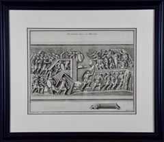
18th Century Engraving "Attack with a Battering Ram" by Montfaucon
Located in Alamo, CA
This early original copper-plate engraving entitled "Attaque avec le Belier" from 'L'antiquité expliquée et représentée en figures' (Antiquity Explained and Represented in Diagrams), published in Paris in 1719 by Bernard de Montfaucon. It depicts an ancient...
Category
Early 18th Century Old Masters Landscape Prints
Materials
Engraving
L'Isle de France: A Hand-colored 17th Century Map by De Wit
By Frederick de Wit
Located in Alamo, CA
This colorful and detailed 17th century hand-colored copperplate map by Frederick De Wit was published in Amsterdam between 1666 and 1760. The map depicts the Île-de-France, which is one of the ancient provinces of France. Paris is located in the center of the map, with Versailles to the southwest The map extends from Rouen in the west to Reims in the east. The area around Paris, the Véxin Français, was the original domain of the king of France. Other areas were ruled by French feudal lords. For example, the Véxin Normand area was the domain of the Duke of Normandy...
Category
Early 18th Century Old Masters More Prints
Materials
Engraving

"Allegory of Justice": A 17th Century Old Master Engraving by van Swanenburg
By Willem van Swanenburg
Located in Alamo, CA
This old master engraving entitled "Allegorie op de Rechtspraak" is by Willem van Swaanenburg after a painting by Joachim Wtewael, published by Ch...
Category
Early 1600s Old Masters Interior Prints
Materials
Engraving
You May Also Like
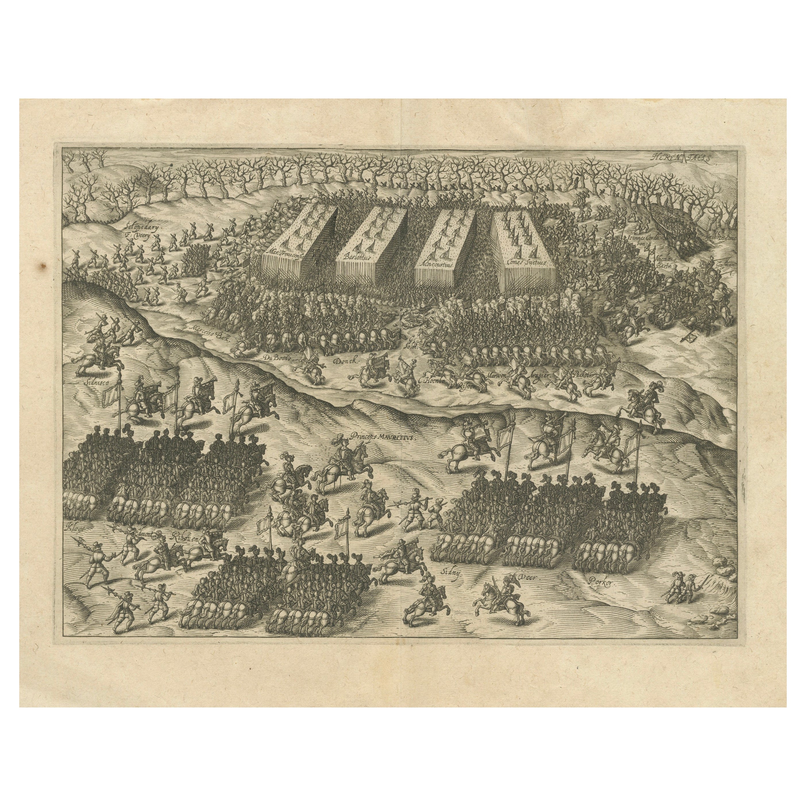
Rare Print of the Siege of Doornik Between the English and French Armies, c.1680
Located in Langweer, NL
Antique print of the Siege of Doornik (Tournai) in 1581, during the Eighty Years' War. This print most likely originates from an edition of 'Histoire de la guerre de Flandre' by F. S...
Category
Antique 17th Century Prints
Materials
Paper
$440 Sale Price
20% Off
The Siege of Nyborg, 1659: A Strategic Battle of the Dano-Swedish War, 1746
Located in Langweer, NL
Title: "The Siege of Nyborg, 1659: A Strategic Battle of the Dano-Swedish War"
Translated text (From Dutch) on copper engraving: "The city of Nyborg captured by the lord Michiel de ...
Category
Antique 1740s Prints
Materials
Paper
$210 Sale Price
20% Off
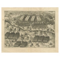
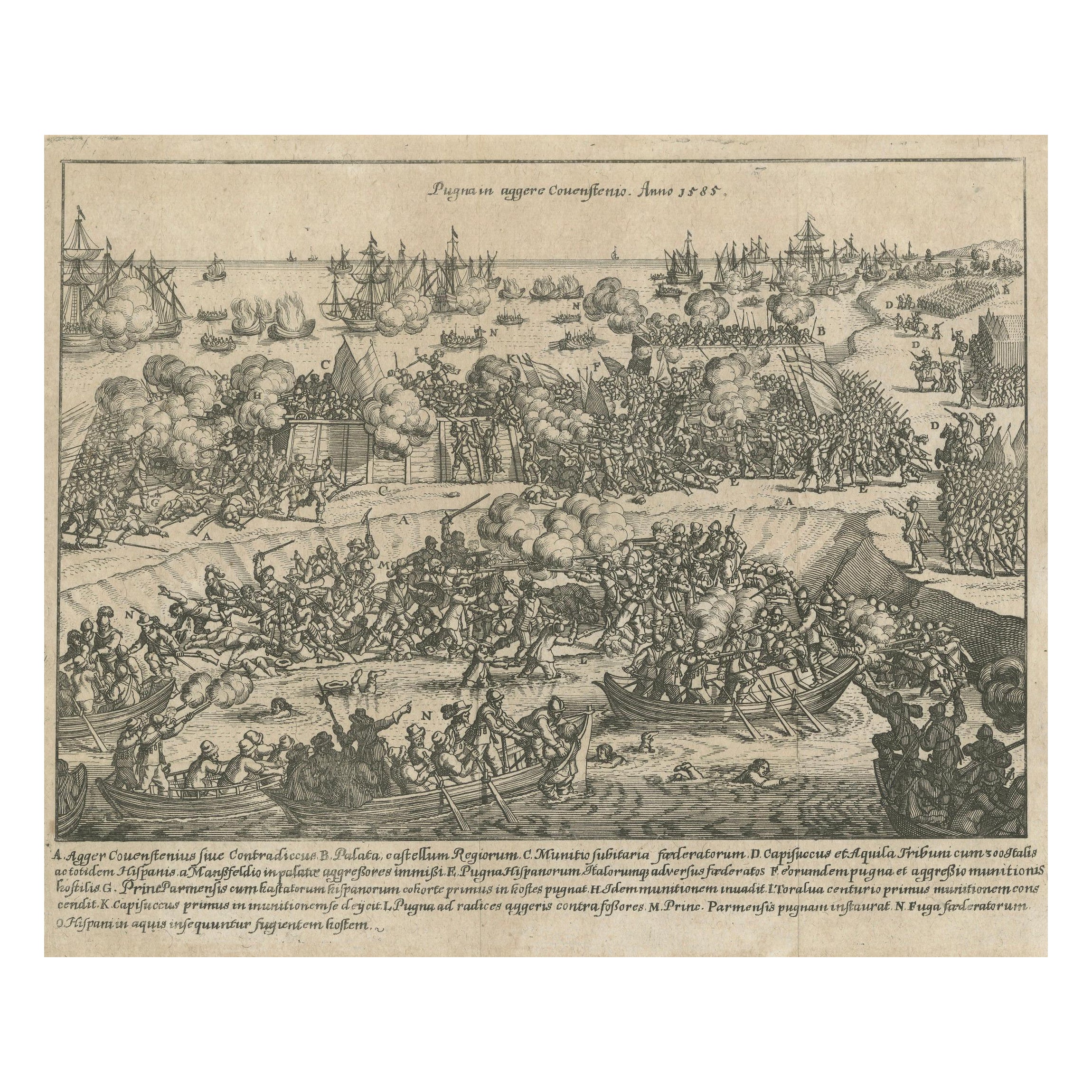
Battle of Kauwenstein Dijk, 1585: Siege of Antwerp Engraving with Latin Legend
Located in Langweer, NL
The 'Battle for the Kauwenstein Dijk', engraved and titled Pugna in Aggerere Covenstio Anno 1585, depicts a significant battle during the Siege of Antwerp on 26 May 1585.
The engraving illustrates the fierce combat around the Kauwenstein embankment, where the Spanish forces under the Duke of Parma attempted to cut off supplies to the city of Antwerp, leading to intense fighting.
The scene vividly portrays soldiers engaged in close combat, naval forces in the background, and smoke rising from the battlefield as cannon fire and musket shots fill the air. The embankment, partially breached, is a focal point, showing the chaotic nature of the battle as forces from both sides converge.
At the top, the title is inscribed in Latin, and a detailed legend (A-O) at the bottom provides further explanations about various parts of the battle, referencing key locations, troops, and actions. The detailed precision of the engraving reflects the high level of craftsmanship typical of 16th-century military engravings...
Category
Antique 16th Century Prints
Materials
Paper
$277 Sale Price
20% Off
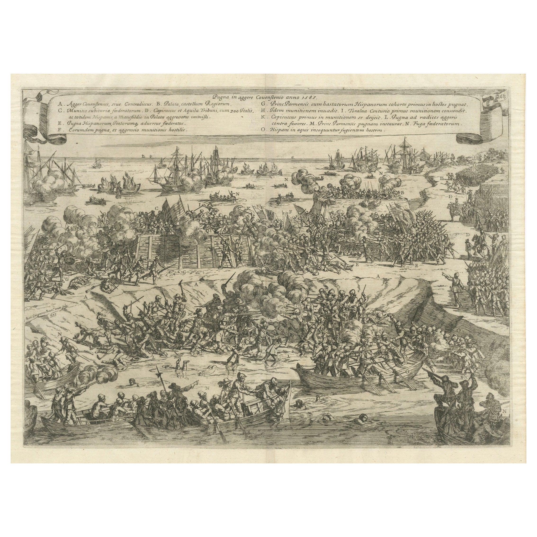
Siege and Struggle: The Kauwensteinse Dike in the Eighty Years' War, 1647
Located in Langweer, NL
Battle on the Kauwensteinse dike, 26 mai 1585, attack from the Staten army and ships from Sealand on the dike against the Spanish in the Eighty Years' War.
An original historical ar...
Category
Antique 1640s Prints
Materials
Paper
$803 Sale Price
20% Off
Free Shipping
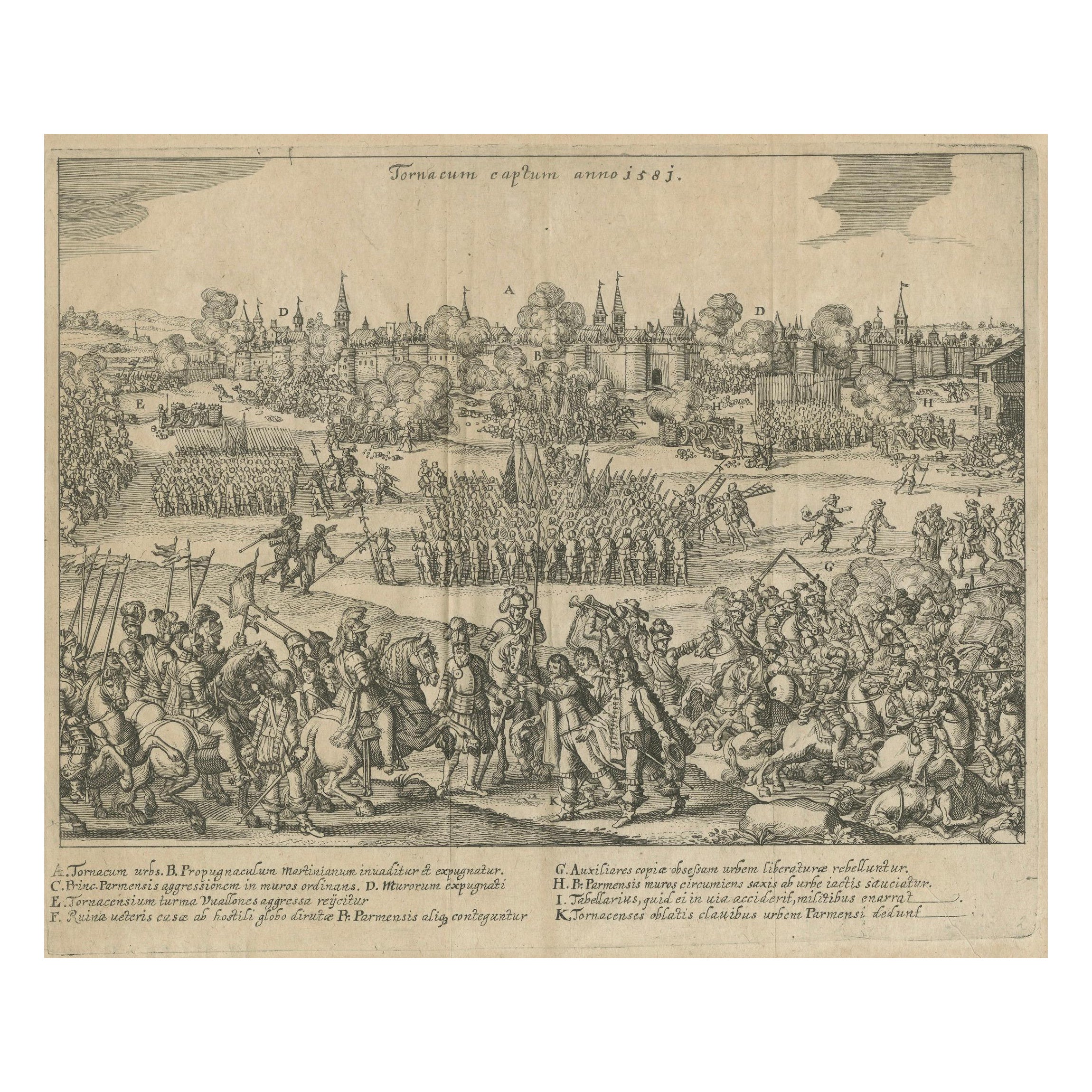
Capture of Tournai by Parma's Forces, 1581: Siege and Conquest of the City
Located in Langweer, NL
This detailed engraving depicts the capture of Tournai by the forces of the Duke of Parma in 1581. The scene shows the siege and conquest of the city with meticulous illustrations of...
Category
Antique 16th Century Prints
Materials
Paper
$276 Sale Price
20% Off
Battle of Turnhout 1597 – Dutch and English Victory over Spanish, Published 1700
Located in Langweer, NL
Battle of Turnhout 1597 – Dutch and English Victory over Spanish
This original antique engraving depicts the Battle of Turnhout, fought on January 24, 1597, during the Eighty Years’...
Category
Antique Early 18th Century Dutch Prints
Materials
Paper