Items Similar to An Antique Engraved View of Copper Mining in Sweden in the 17th C. by Dahlberg

Want more images or videos?
Request additional images or videos from the seller
1 of 8
Erik DahlbergAn Antique Engraved View of Copper Mining in Sweden in the 17th C. by Dahlberg1705
1705
$460
$57520% Off
£350.88
£438.6020% Off
€399.76
€499.7020% Off
CA$646.53
CA$808.1720% Off
A$705.35
A$881.6920% Off
CHF 373.48
CHF 466.8520% Off
MX$8,452.12
MX$10,565.1520% Off
NOK 4,756.47
NOK 5,945.5920% Off
SEK 4,349.44
SEK 5,436.8020% Off
DKK 2,984.96
DKK 3,731.2020% Off
About the Item
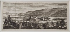
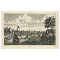
This is an antique engraved view entitled "Fodinae aerariae Falunenfis, qui orientem fpectat, delineatio" (Copper mining in Falun), Sweden in 1705 from "Sueciae Antiquae et Hodiernae"' published in Stockholm by Erik Dahlberg (1625-1703). The engraving was created by Johannes van den Aveelen (1650-1727), who was an accomplished copperplate engraver who emigrated to Sweden to work on Dahlberg's spectacular book, "Sueciae Antiquae et Hodiernae", which was focused on the views and architecture of Sweden, both in the ancient past and at the time of the publication.
This engraving depicts a very active 17th century working scene at the Great Copper Mountain Mine in Falun, Sweden as it appeared in 1687 when the original drawing was created. The mine operated for a millennium from the 10th century to 1992. It produced as much as two thirds of Europe's copper needs and helped fund many of Sweden's wars in the 17th century. Technological developments at the mine influenced global mining for two centuries. The mine is now a museum and in 2001 was designated a UNESCO world heritage site.
The engraving is presented in a cream colored mat that is suitable for framing. The mat measures 17.25" x 12.25" and the visible portion measures 11.13" x 15.38". There is a central vertical fold as issued. The print is excellent condition.
"Suecia Antiqua et Hodierna" (Ancient and Modern Sweden) is a collection of engravings created and comissioned by Erik Dahlberg during the middle of the 17th century. Dahlberg was an artist and architect, with the official role of Surveyor-General of the Ordinance, Quarter-Master General and Field Marshal of Sweden in the 17th century. "Suecia Antiqua et Hodierna" was his grand vision of Sweden during its period as a great world power. Dahlberg's direct source of inspiration was the topographical views issued by the Swiss artist and publisher Matthäus Merian. In 1661 Dahlberg was granted a royal privilege enabling him to pursue his plan. He created a large number of sketches and drawings depicting settlements, manors, and fortifications, with the expressed purpose of enhancing the glory of Sweden, much as Giovanni Piranesi would later do for Rome several decades later. The drawings were later engraved by a number of leading contemporary European engravers. Unfortunately the work was not published until 1705, two years after his death. In its final state "Suecia Antiqua et Hodierna" comprised three volumes containing 353 plates, many with two engravings per sheet. It is considered to be the greatest and finest engraved work ever produced in Scandinavia.
- Creator:Erik Dahlberg (1625 - 1703)
- Creation Year:1705
- Dimensions:Height: 17.25 in (43.82 cm)Width: 21.25 in (53.98 cm)
- Medium:
- Movement & Style:
- Period:
- Framing:Framing Options Available
- Condition:
- Gallery Location:Alamo, CA
- Reference Number:Seller: # 41401stDibs: LU117325568251
About the Seller
5.0
Platinum Seller
Premium sellers with a 4.7+ rating and 24-hour response times
Established in 2011
1stDibs seller since 2019
298 sales on 1stDibs
Typical response time: 1 hour
- ShippingRetrieving quote...Shipping from: Alamo, CA
- Return Policy
More From This Seller
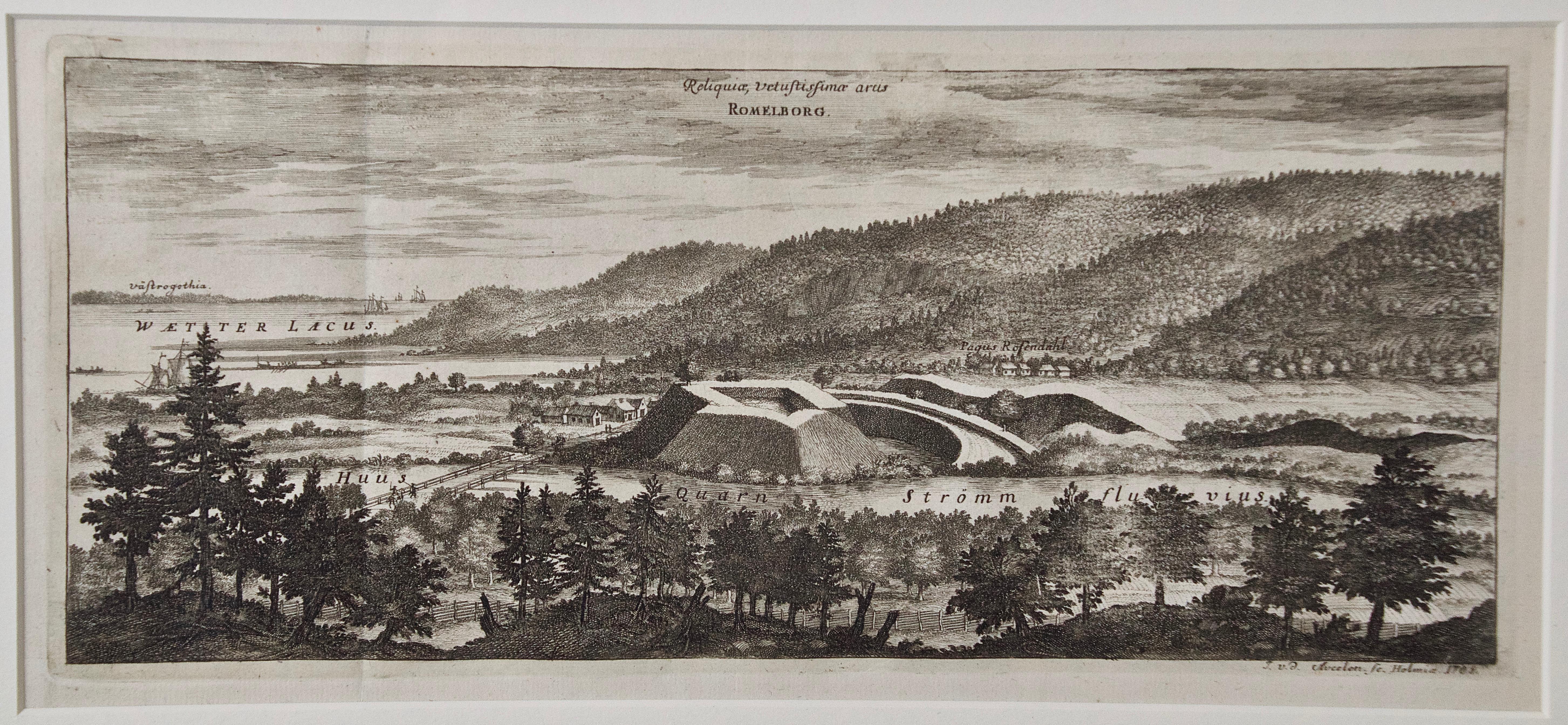
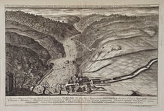
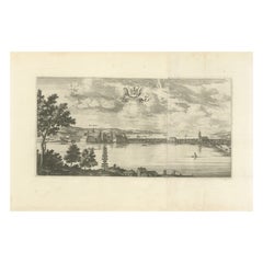
View AllAn Antique Engraved View of "Romelborg", Sweden in the 17th C. by Erik Dahlberg
By Erik Dahlberg
Located in Alamo, CA
An antique engraved view of "Romelborg", Sweden in 1705 from "Sueciae Antiquae et Hodiernae"' published in Stockholm by Erik Dahlberg (1625-1703). The engraving was created by Johan...
Category
Early 18th Century Naturalistic Landscape Prints
Materials
Laid Paper, Engraving
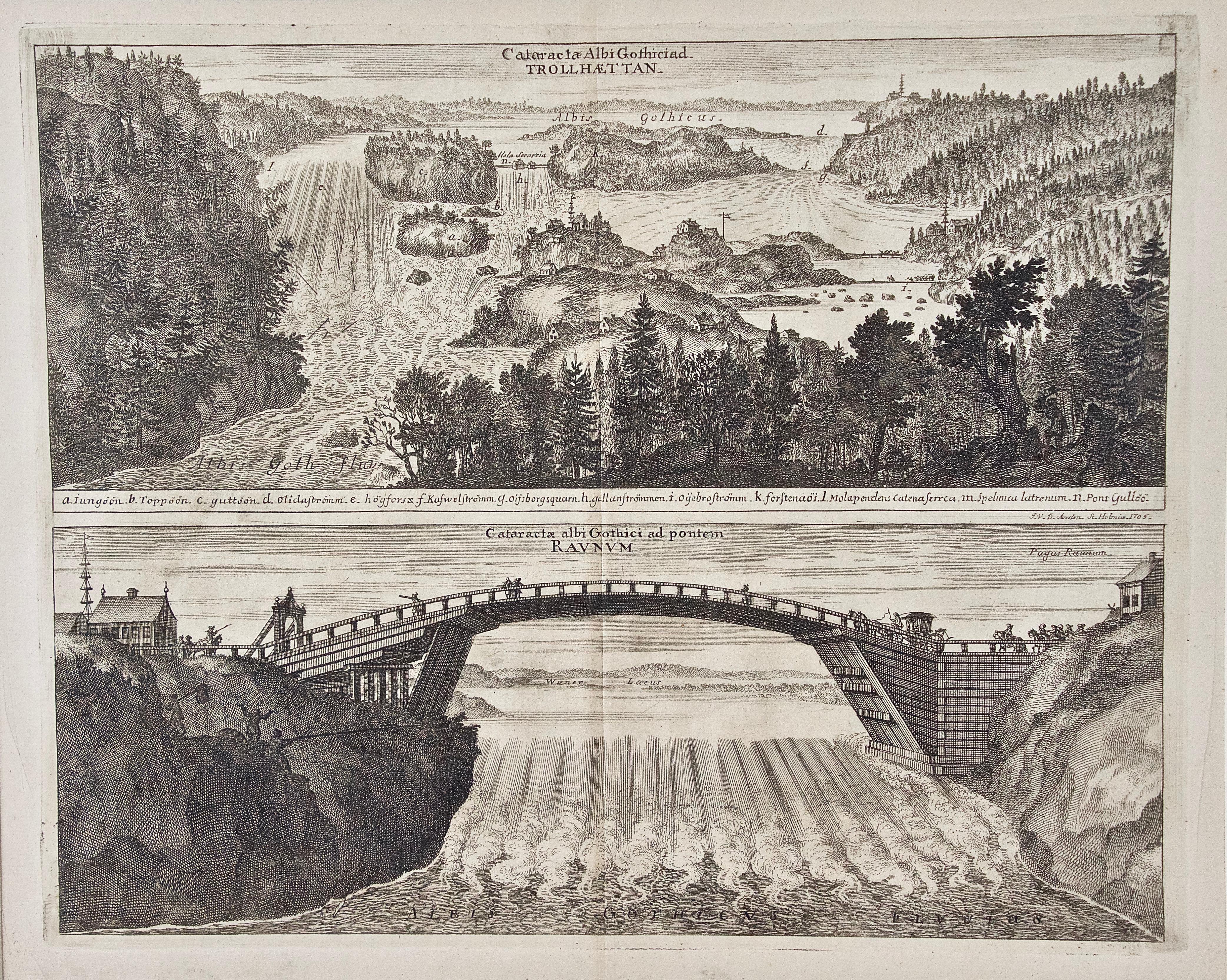
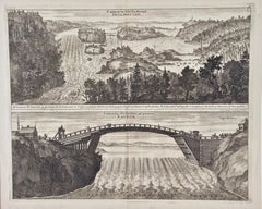
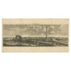
An Antique Engraved View of Waterfalls in Sweden in the 17th C. by Erik Dahlberg
By Erik Dahlberg
Located in Alamo, CA
Two antique engraved views on one sheet of "Cataractae Albi Gothicead Trollhaettan" and "Cataractae Albi Gothici ad Pontiff Raunum" (Waterfalls Near Trollhaettan and Raunum), Sweden ...
Category
Early 18th Century Naturalistic Landscape Prints
Materials
Laid Paper, Engraving
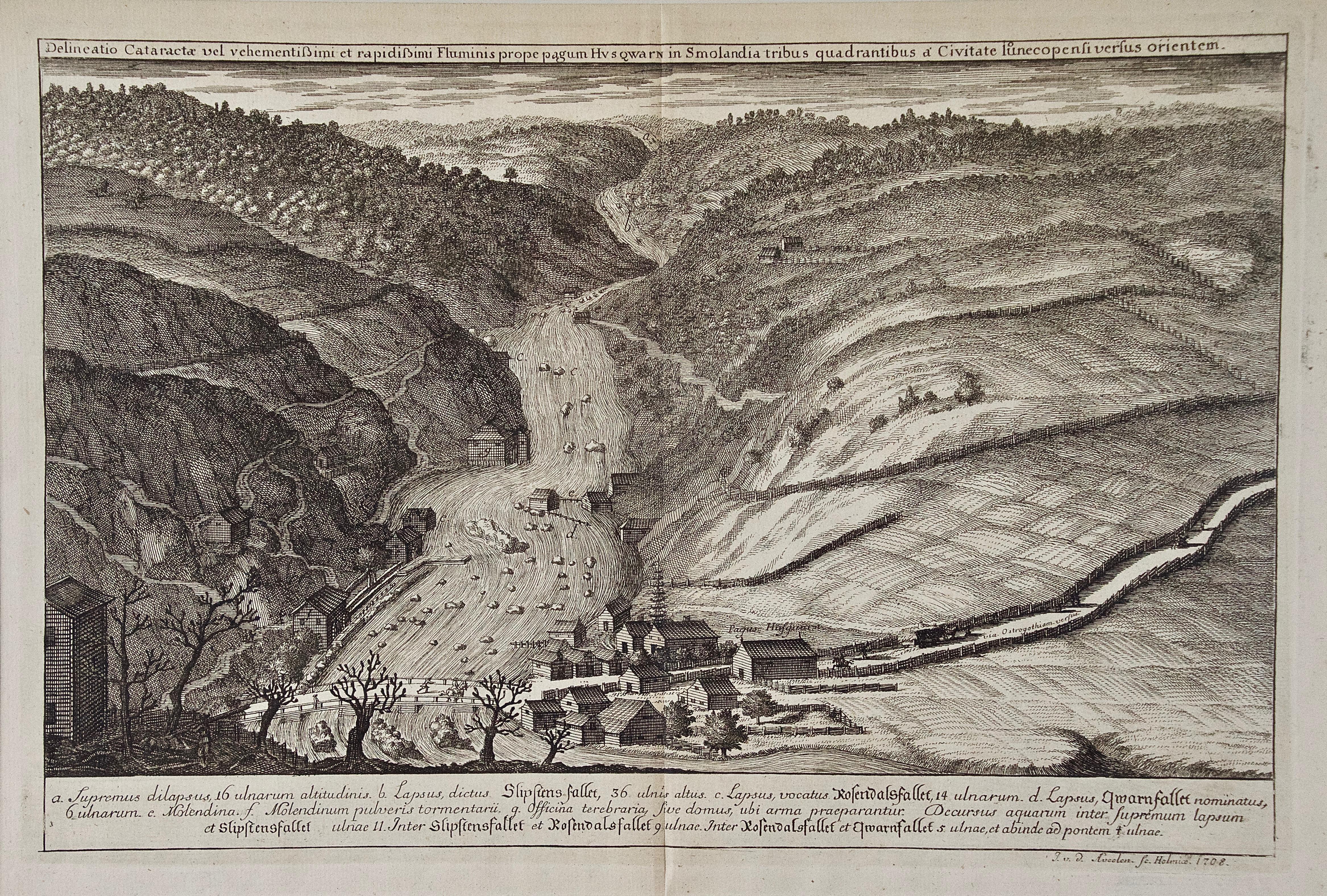
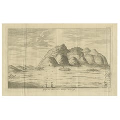
An Antique Engraved View of "Waterfalls in Smoland", Sweden by Erik Dahlberg
By Erik Dahlberg
Located in Alamo, CA
This is an antique engraved view entitled "Delineatio Cataractae" (Waterfalls in Smoland), Sweden in 1705 from "Sueciae Antiquae et Hodiernae"' published in Stockholm by Erik Dahlber...
Category
Early 18th Century Naturalistic Landscape Prints
Materials
Laid Paper, Engraving
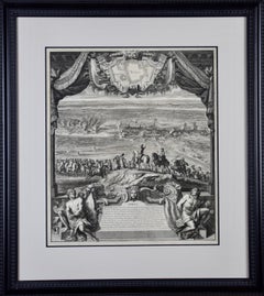
Daniel Marot's The Siege of the Dutch Fortified City of Ypres by Louis XIV
By Daniel Marot
Located in Alamo, CA
"Ypres, Grand Ville Riche & Marchande" is an engraving and etching by Daniel Marot (le Vieux) (1661–1752). It depicts a view of the siege of the city of Ypres and its citadel on the left in the Spanish Netherlands by Louis XIV's troops. This battle took place between March 18 and March 25, 1678, as part of the Franco-Dutch War. Marot illustrated in great detail (best appreciated with magnification) the French attack on the strong pentagonal citadel on the extreme left, which had been built recently in anticipation of a French attack. The trenches built by the French approaching the town are seen on the right. King Louis XIV can be seen in the foreground surveying the battle mounted on his white horse, surrounded by his officers and troops.
The print is presented in an attractive ornate black wood frame with a cream-colored double mat with a black inner trim. It is glazed with plexiglas. The frame measures 25.38" x 22.63" x .88". The engraving, frame, mat and glazing are in excellent condition.
Artist: Daniel Marot (1661–1752) was also called "Le Vieux". He was the son of the famous architect, Jean Marot. Marot had diverse interests and talents. In addition to his art, he designed garden projects, architectural ornaments, furniture, and even upholstery. Marot as a Huguenot protestant was forced to leave France in 1685 following the revocation of the Edict of Nantes. He emigrated to Holland, where he worked for William of Orange (an arch enemy of his former employer Louis XIV). Marot was largely responsible for the interiors of Williams palace at the Loo. In 1694 he went Britain as William had married Queen Mary and he had become King William III of England. He later returned to Holland in about 1698 and died in the Hague in 1752. He left a lasting legacy on the decorative arts in the Netherlands, where his grand version of the Louis XIV style remained popular into the 1730s.
Historical Background: In October 1677, Mary Stuart, niece and possible successor of Charles II of England, married Louis XIV's arch enemy William III of Orange...
Category
Late 17th Century Old Masters Landscape Prints
Materials
Engraving, Etching
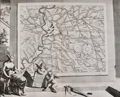
18th Century French Map and City View of Joppe/Jaffa (Tel Aviv) by Sanson
By Nicholas Sanson d'Abbeville
Located in Alamo, CA
An original antique engraving entitled "Joppe; in ’t Hebreeusch by ouds Japho; hedendaags Japha, of Jaffa; volgens d’aftekening gedaan 1668", by Nicholas Sanson d'Abbeville (1600 - 1667). This is a view of the city of Joppe (in Hebrew Japho), now called Japha or Jaffa, the harbor portion of modern day Tel Aviv, Israel as it appeared in 1668 . It depicts a very busy harbor with numerous boats. A large ship on the left appears to be firing its canons and a small ship on the right appears to be sitting very low in the water, either heavily loaded with cargo or sinking. The town is seen on the far shore with a fortress on a hill across in the background. The map is printed from the original Sanson copperplate and was published in 1709 by his descendants.
The map is presented in an ornate brown wood frame embellished by gold-colored leaves and gold inner trim with a double mat; the outer mat is cream-colored and the inner mat is black. There is a central vertical fold, as issued. There are two small spots in the lower margin and one in the upper margin, as well as two tiny spots adjacent to the central fold. 1717 is written below the date 1668 in the inscription. The map is otherwise in very good condition.
Another map of the "Holy Land" (by Claes Visscher in 1663), with an identical style frame and mat is available. This pair of maps would make a wonderful display grouping. Please see Reference #LU117324709892.
Artist: Nicholas Sanson d'Abbeville (1600 - 1667) and his descendents were important French cartographer's active through the 17th century. Sanson started his career as a historian and initially utilized cartography to illustrate his historical treatises. His maps came to the attention of Cardinal Richelieu and then King Louis XIII of France, who became a supporter and sponsor. He subsequently appointed Sanson 'Geographe Ordinaire du Roi' the official map maker to the king. Sanson not only created maps for the king, but advised him on geographical issues and curated his map collection...
Category
Early 1700s Prints and Multiples
Materials
Engraving

Roman Hills, Aqueducts and Roads: An Early 18th Century Map by Jan Goeree
Located in Alamo, CA
This richly engraved map of Rome and its environs entitled "Urbis Cum Vicis Seu Pagis Adiacentibus Dissertationi III De Aq et Aqueaed Veteris Promae Praemissa Authore Raph Fabretto G...
Category
Early 18th Century Old Masters Landscape Prints
Materials
Engraving
You May Also Like
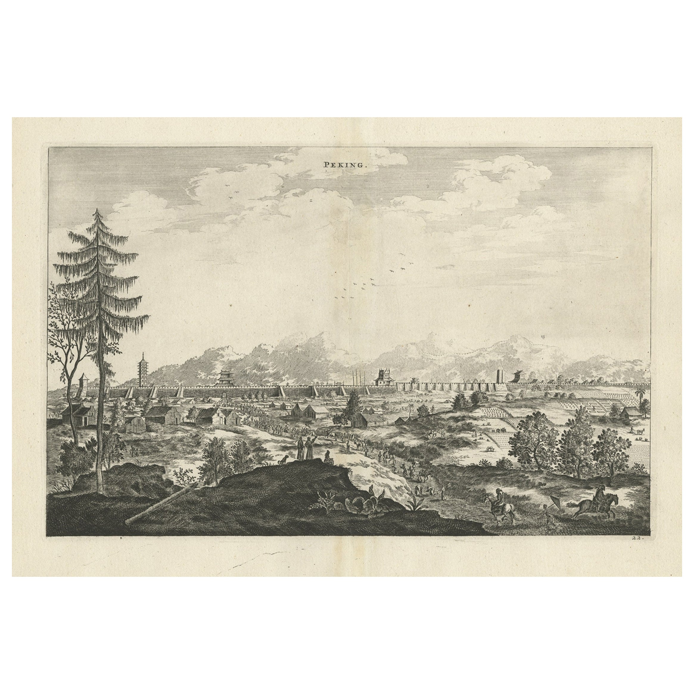
Original Copper Engraved Antique Print of the City of Bejing in China, 1668
By Johannes Nieuhof
Located in Langweer, NL
Antique print China titled 'Peking'. Old print depicting a view of Bejing in China with its ramparts. On the left a pagoda. This print originates from the Latin edition of Nieuhof's ...
Category
Antique 17th Century Prints
Materials
Paper
$517 Sale Price
20% Off
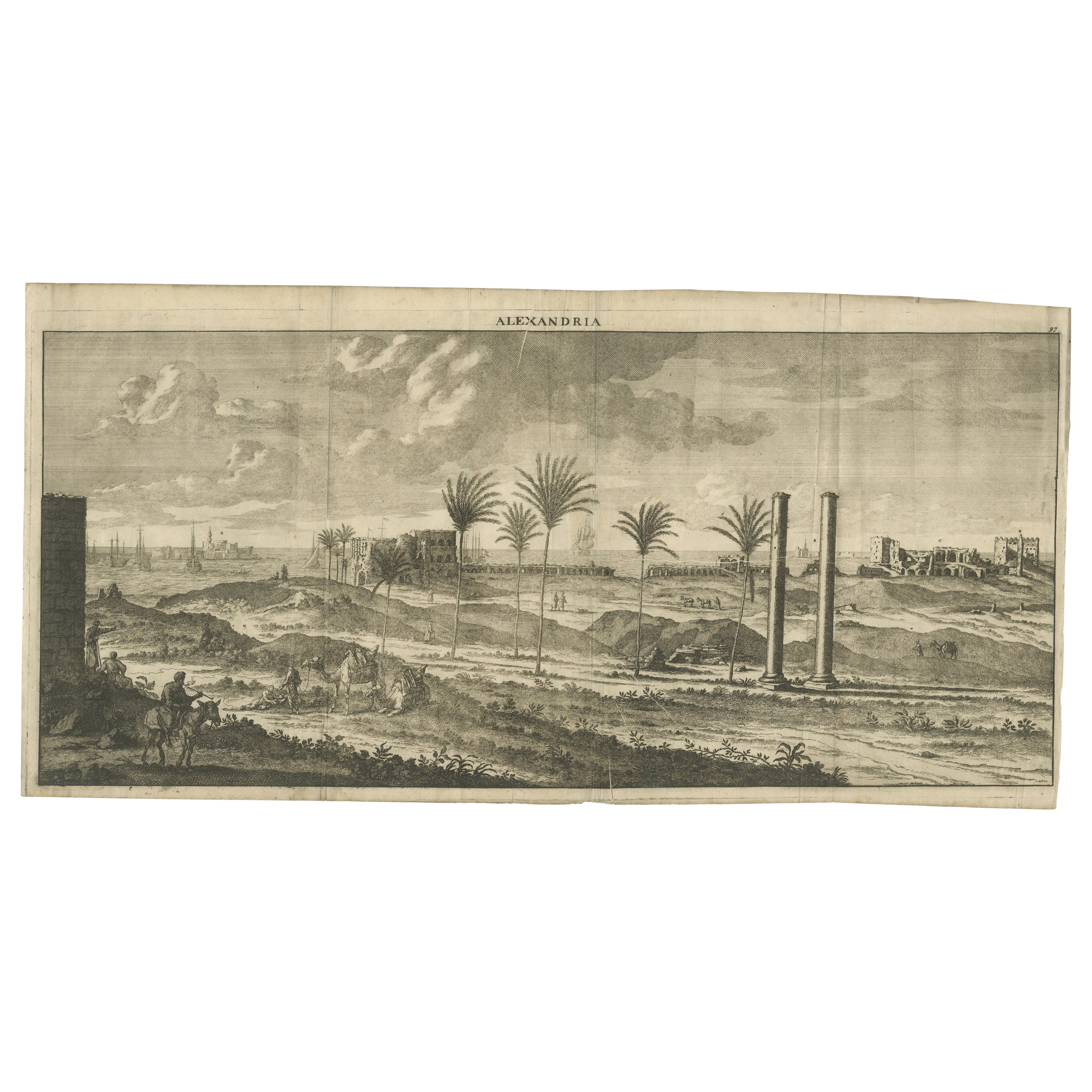
Copper-Line Engraving by Cornelius de Bruyn of Alexandria in Egypt, c.1690
Located in Langweer, NL
Artist: Cornelis de Bruijn (or de Bruyn); 1652 – 1726/7 was a Dutch artist and traveler. He made two large tours and published illustrated books with his observations of people, buil...
Category
Antique Late 17th Century Prints
Materials
Paper
Antique Copper Engraving of the City of Kuchin in China, 1668
By Johannes Nieuhof
Located in Langweer, NL
Antique print China titled 'Kuching'.
Old print depicting a view on the Chinese city of Kuching or Kuchin (Gui Jiang, Kuei Chiang), near the river Gui (Guei). This area is close ...
Category
Antique 17th Century Prints
Materials
Paper
$325 Sale Price
20% Off
Antique Engraving of Königsberg from Suecia Antiqua et Hodierna, c.1690
Located in Langweer, NL
Antique Engraving of Königsberg from *Suecia Antiqua et Hodierna*, c.1690
Original 17th-century engraving from the celebrated work Suecia Antiqua et Hodierna, directed by the Swedis...
Category
Antique Late 17th Century Swedish Prints
Materials
Paper
Copper-Line Engraving by Cornelius de Bruyn of Alexandria in Egypt, c.1690
Located in Langweer, NL
Artist: Cornelis de Bruijn (or de Bruyn); 1652 – 1726/7 was a Dutch artist and traveler. He made two large tours and published illustrated books with his observations of people, buil...
Category
Antique Late 17th Century Prints
Materials
Paper
View of Thebes from the West Bank of the Nile – Engraving by Pococke, 1776
Located in Langweer, NL
View of Thebes from the West Bank of the Nile – Engraving by Pococke, 1776
This striking antique engraving, titled "Gezigt van Thebe, aan de Westzyde van de Nyl" (View of Thebes, on...
Category
Antique Late 18th Century Dutch Prints
Materials
Paper
More Ways To Browse
Engraved Copper
Antique Mining
17th Century Copper
Antique Swedish Copper
Antique Wayang Golek Puppets
Betsy Brown
Bronze Balloon
Cinque Terre
Clay Sculpture Nude
Contemporary Bronze Bust
Cupid Oil On Canvas
Frank Thomas
Goddess Kannon
Henley Regatta
Henry Russell
Humpback Whale
Indonesian Golek Puppet
John Barrymore