Items Similar to "The World" Published by Cummings & Hilliard, No. 1, Cornhill, Boston
Want more images or videos?
Request additional images or videos from the seller
1 of 11
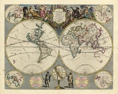
Jacob Abbot Cummings"The World" Published by Cummings & Hilliard, No. 1, Cornhill, Boston1821
1821
$500
£382.41
€437.63
CA$711.64
A$770.50
CHF 409.64
MX$9,292.71
NOK 5,151.42
SEK 4,802.59
DKK 3,268.56
About the Item
"The World" Published by Cummings & Hilliard, No. 1, Cornhill, Boston
Early 19th century engraved double hemisphere Atlas Map, titled "The World." Hand colored original outlines. Published by Cummings and Hilliard in Cornhill, Boston.
The Western Hemisphere is seen on the left, with the Eastern Hemisphere depicted on the right.
"The World" "Published by Cummings, Hilliard & Co" "No 1 Cornhill, Boston." printed in middle.
Presented in a white mat.
Mat: 20"H x 24"L
Image: 9.75"H x 17.25"W
Jacob Abbot Cummings was born in Hollis, New Hampshire in 1773 and attended Harvard University, class of 1801.
As a bookseller and publisher, his business partners included William Andrews (Andrews & Cummings, 1807–1809) and William Hilliard (Cummings & Hilliard, 1812–1820).
Cummings "kept a school for both girls and boys" in Boston. He "seems to have been ahead of his time in both the style and content of his teaching. ... He wrote a textbook, An Introduction to Ancient and Modern Geography, giving something of his pedagogical philosophy in the preface. 'It will not be profitable to confine the young mind long to any one part of the earth. ... No small injury is frequently done to young persons, by attempting to make them perfect in what they the first time commit to memory, especially if it be somewhat difficult.'"
After his death in 1820, Cummings' "private library" was auctioned at the office of Blake & Cunningham on Kilby Street in Boston.
- Creator:Jacob Abbot Cummings (1772 - 1820, American)
- Creation Year:1821
- Dimensions:Height: 20 in (50.8 cm)Width: 24 in (60.96 cm)Depth: 0.5 in (1.27 cm)
- Medium:
- Movement & Style:
- Period:
- Condition:Very good condition. Some normal wear and age toning consistent with age. Some cracking along crease.
- Gallery Location:Soquel, CA
- Reference Number:Seller: N91671stDibs: LU54214178972
About the Seller
5.0
Platinum Seller
Premium sellers with a 4.7+ rating and 24-hour response times
Established in 1986
1stDibs seller since 2014
3,049 sales on 1stDibs
Typical response time: <1 hour
- ShippingRetrieving quote...Shipping from: Soquel, CA
- Return Policy
More From This Seller
View AllEarly 18th Century Globe Terrestre Engraving
By Francois Halma
Located in Soquel, CA
Wonderfully detailed steel engraving of the earth, locations labeled in French: Afrique, Grande Tartarie, La Chine, etc., by By Francois Halma (Dutch, 1653-1722), 1705. Interesting f...
Category
Early 1700s Realist Landscape Prints
Materials
Paper, Ink
$460 Sale Price
20% Off
Charte von Sud-America (Map of South America) - Etching with Hand-Drawn Outlines
Located in Soquel, CA
Map of south America, engraved by Franz Pluth (Czech, 1800-1871), from the book "Neueste Länder - und Völkerkunde, ein geographisches Lesebuch für alle Stände" by Linder, F. L. (Prag...
Category
1820s Other Art Style More Prints
Materials
Paper, Printer's Ink, Etching

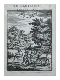
Native Civilians of America -- "De L'Amerique" Published Frankfurt / 1683
By Alain Manesson Mallet
Located in Soquel, CA
Wonderful etching, originally page 365 in a book De L'amerique by Alain Manesson Mallet, circa 1683, depicts the artist's concept of the appearance and activities of the native occupants of America in graphic detail. Unsigned. Displayed in a black and giltwood frame. Image, 6.5"H x 4.5"L.
1683 Manesson Mallet "Bresiliens" Amerindians, Indigenous Native Brazilians, Brazil, South America, Antique Print...
Category
1680s Realist Figurative Prints
Materials
Paper, Ink, Woodcut
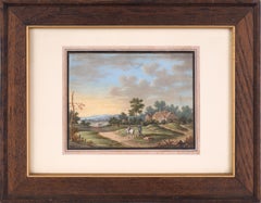
The Country House - Farm Landscape
Located in Soquel, CA
The Country House - Farm Landscape
Highly detailed scene with a country house, workers, and a hare with rider by an unknown artist (19th Century). Five people - one on a horse - are...
Category
19th Century Realist Landscape Paintings
Materials
Paper, Watercolor, Gouache
$1,080 Sale Price
20% Off
19th Century Hudson River School Landscape after Richard Goodwin
Located in Soquel, CA
Charming Hudson River school antique oil painting of a sailboat on a lake, circa 1880-90. Signed "R. Labarr." after Richard LaBarre Goodwin...
Category
1880s Hudson River School Landscape Paintings
Materials
Canvas, Oil

$1,218 Sale Price
35% Off
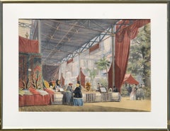
Mid 19th Century Figurative Scene from "Great Exhibition of 1851", London
By Lowes Cato Dickinson
Located in Soquel, CA
Hand-colored steel engraving of a the Turkish section of the Great Exhibition of 1851 by Lowes Cato Dickinson (British, 1819-1908). On verso i...
Category
1850s Aesthetic Movement Interior Prints
Materials
Watercolor, Engraving
You May Also Like
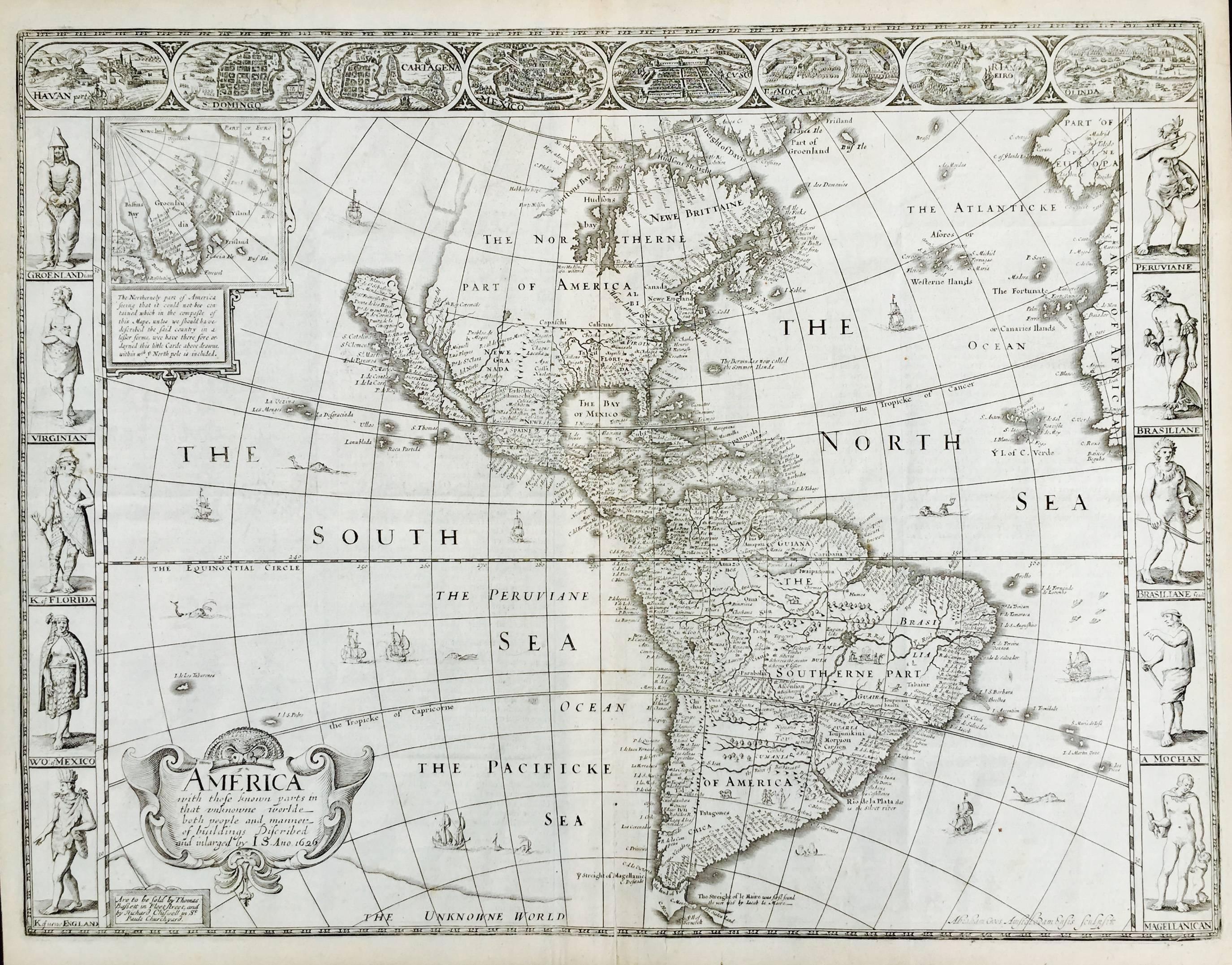
AMERICA
By John Speed
Located in Santa Monica, CA
IMPORTANT AMERICAN MAP - ONE OF THE FIRST TO SHOW CALIFORNIA as an ISLAND
JOHN SPEED (1552-1629)
AMERICA - With Those Known Parts In That Unknown Worlde (sic),
1626-(76)
(Burden 217 iv/iv) Engraving, uncolored. Engraved by Abraham Goos and
published by Thomas Basset and Richard Chiswell - 4th state of 4 in 1676
15 1/8 x 20 1/2” From “A Prospect of the Most Famous Parts of the
World”. Generally good condition. A repaired split in lower centerfold. This
is the most common version of this important map...
Category
1620s Old Masters Landscape Prints
Materials
Engraving

$4,080 Sale Price
52% Off
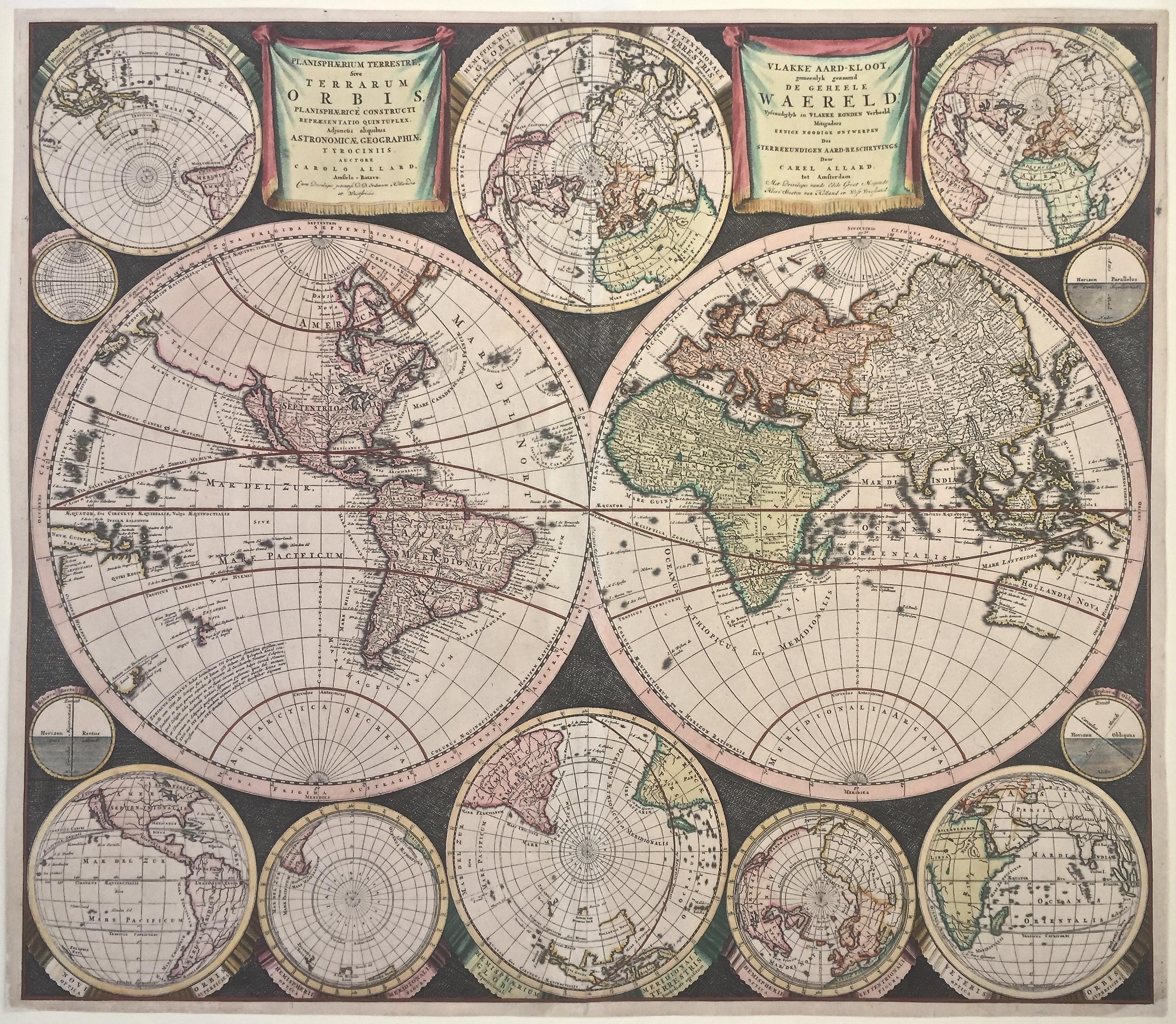
WORLD MAP - Planisphaerium Terrestre Sive Terrarum Orbis... 1696
By Carel Allard
Located in Santa Monica, CA
CAREL ALLARD (1648 – 1709)
PLANISPHAERIUM TERRESTRE SIVE TERRARUM ORBIS… 1696 (Shirley 578)
Engraving, 20 ½ x 23 ½”, sheet 21 x 24 1/8". A stunning double hemisphere World Map...
Category
17th Century Old Masters Landscape Prints
Materials
Engraving

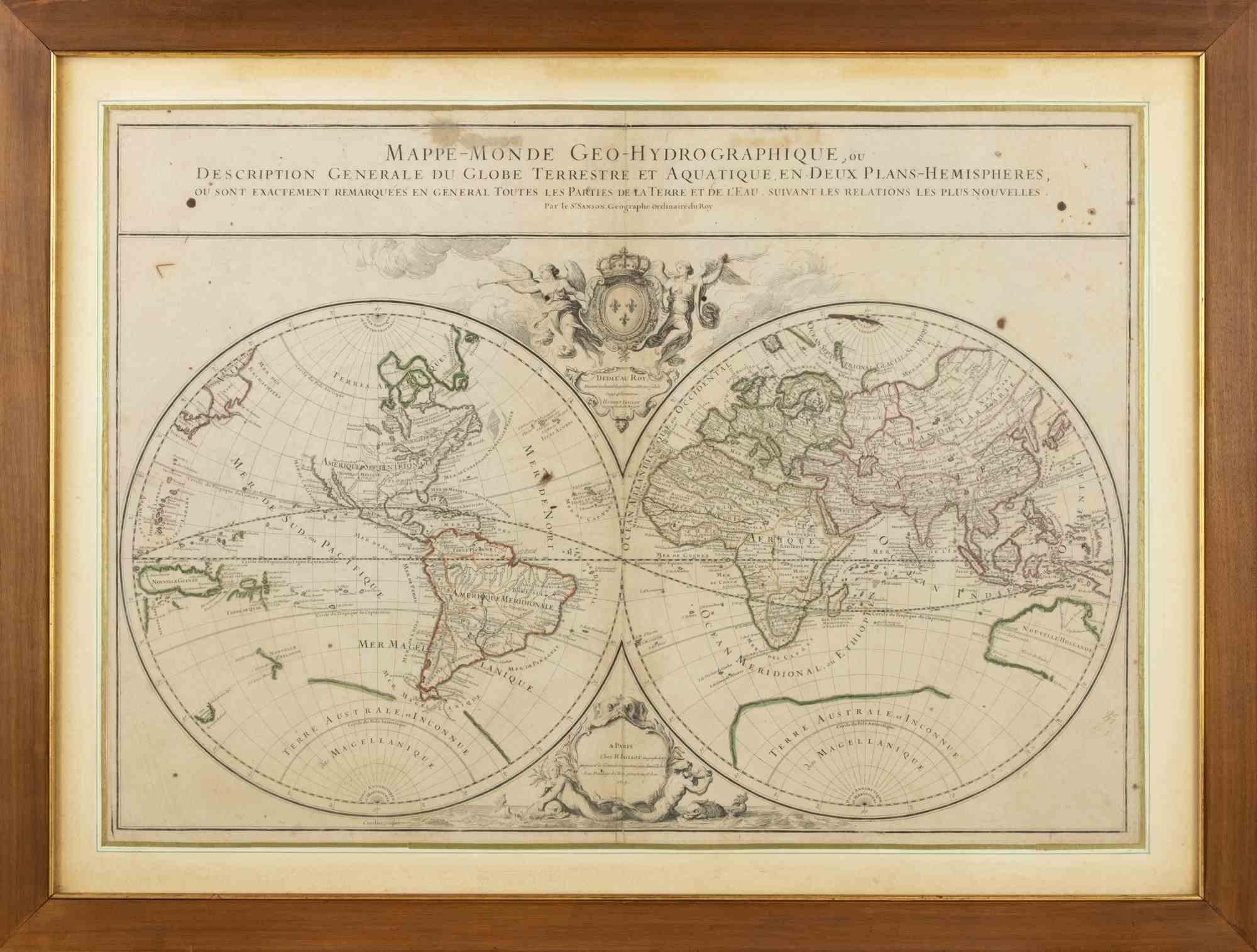
World Map - Etching by Hubert Nicholas-Jaillot - 1719
Located in Roma, IT
World map is an original modern artwork realized by Hubert Nicholas - Jaillot, printed by Louis Cordier in Paris 1719.
Etching on copper
The artwork depicts two hemispheres, conti...
Category
1710s Old Masters Figurative Prints
Materials
Etching

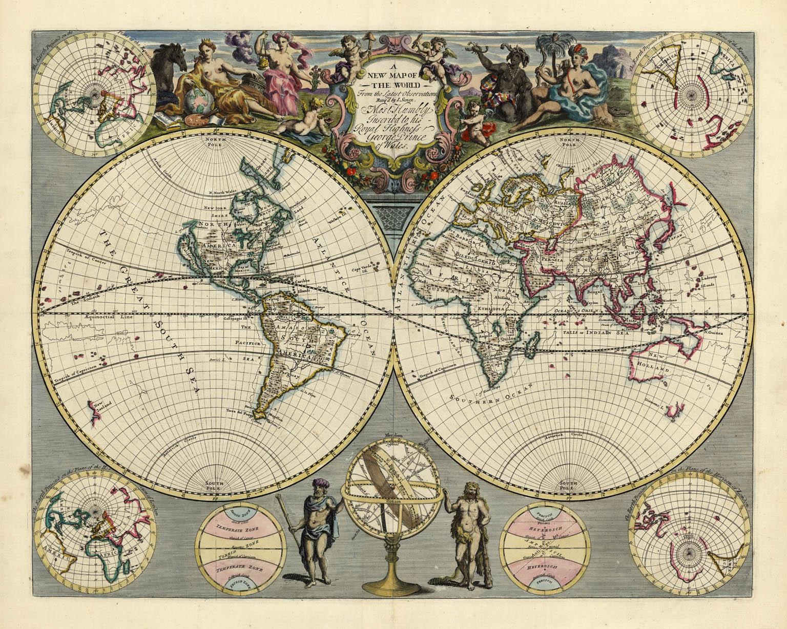
A NEW MAP OF THE WORLD from the Latest Observations.
By John Senex
Located in New York, NY
The title continues “…. Most Humbly Inscribd [sic] to his Royal Highness George Prince of Wales.”
A fine British produced double hemisphere world map. On this map, California is shown as an island on the main double hemisphere map...
Category
18th Century Other Art Style More Prints
Materials
Watercolor, Engraving
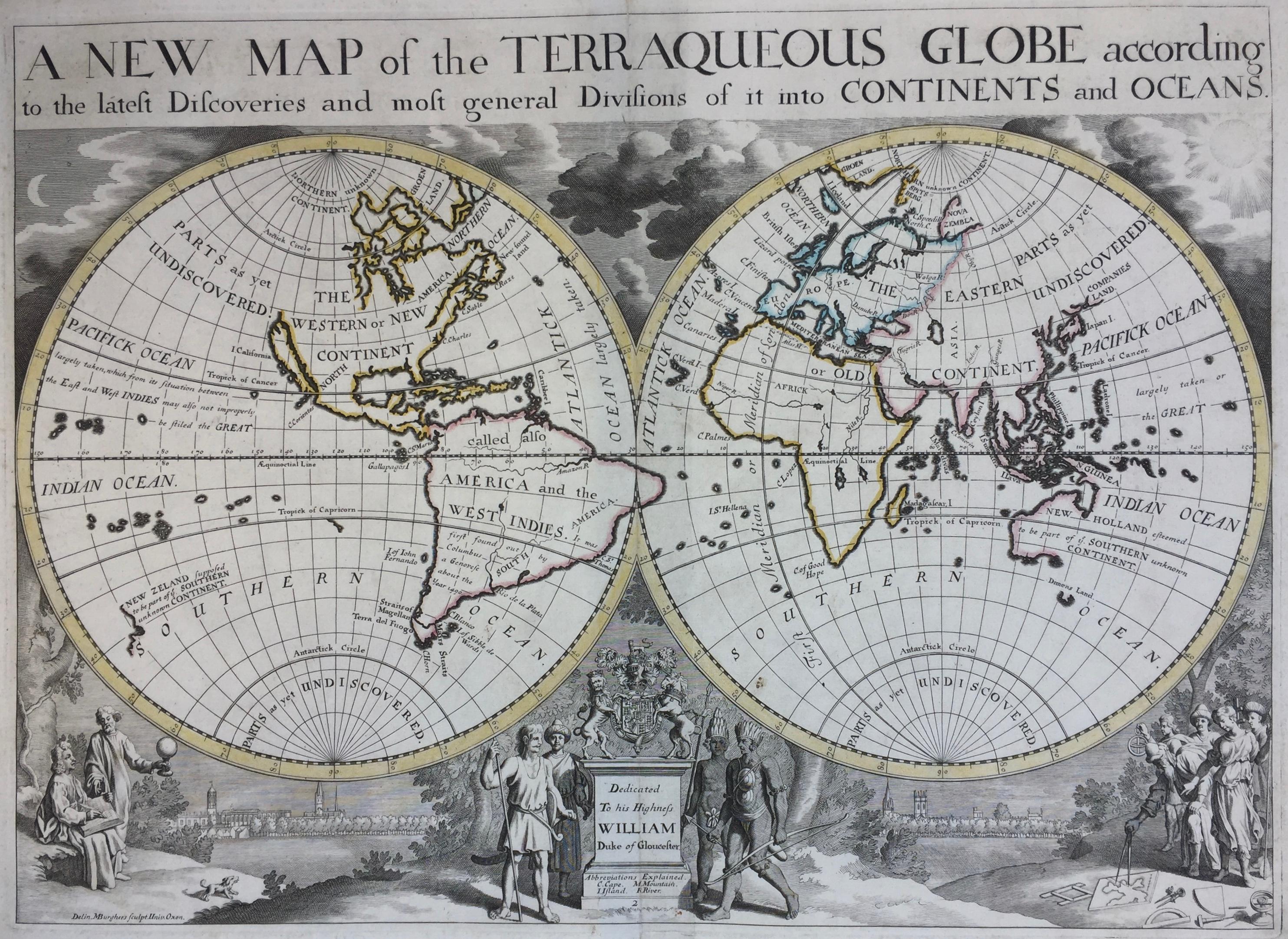
New Map of the Terraqueous Globe - WORLD MAP - CALIFORNIA AS AN ISLAND
By Edward Wells
Located in Santa Monica, CA
EDWARD WELLS (British 1667- 1727)
A NEW MAP of the TERRAQUEOUS GLOBE - according to the latest Discoveries and most general Divisions of it into CONTINENTS and OCEANS, 1700-01 (Shirley 609)
Engraved by Michael Burghers, Oxford. Hand-colored, Platemark 14 1/4 x 20 1/8 inches. Central cartouche flanked by figures representing the continents with dedication to William, Duke of Gloucester...
Category
Early 1700s Old Masters Landscape Prints
Materials
Engraving

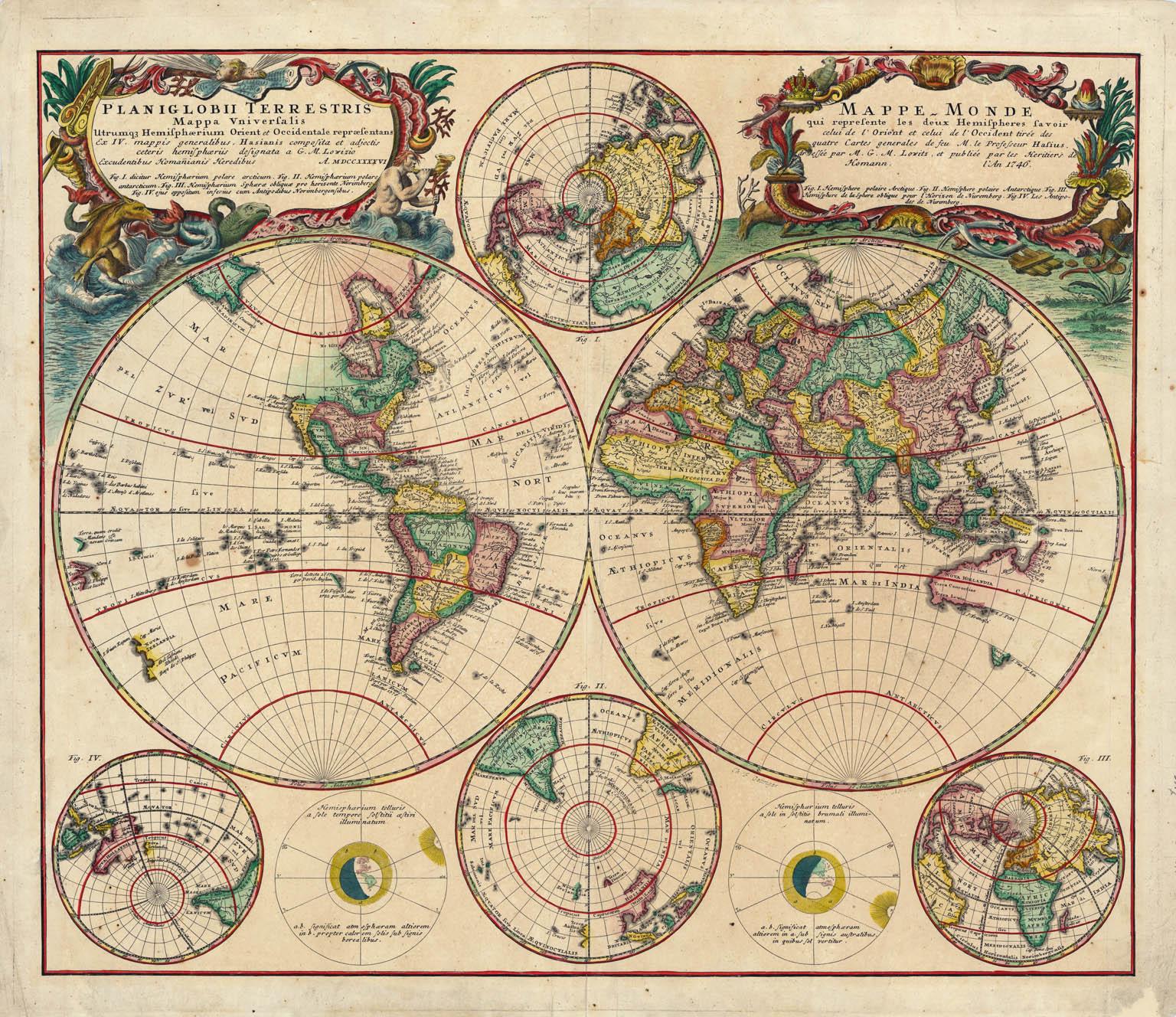
Planiglobii Terrestris Mappa Universalis / Mappe Monde
By Homann Heirs
Located in New York, NY
This map was printed from a copperplate engraving in 1746. The printed image size is 18.25 x 21.75 inches (46.3 x 55.2 cm) plus margins.
An attractive double hemisphere map...
Category
18th Century Other Art Style More Prints
Materials
Engraving

More Ways To Browse
Antique Boston
Hemispheres Map
William Cummings
Colorado Vintage Travel Poster
Colosseum Piranesi
Dali San Francisco
Dali Travel Poster
Earl Thollander
Etching Prague
Ethel Gabain
French Village Etching
George Elbert Burr Etchings
Guy Maccoy
Harold Altman Path
Harold Altman Signed Lithographs
Harry Harris
Joseph Downing
La Panne