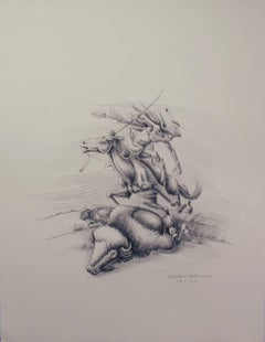
Apache Hunter, limited edition lithograph by Allan Houser, horseback hunter
hand-pulled black and white lithograph
printed in Santa Fe, New Mexico
unframed edition of 75
Allan Houser (Haozous), Chiricahua Apache (1914-1994)
Selected Collections
Centre Georges Pompidou, Paris, France * “They’re Coming”, bronze
Dahlem Museum, Berlin, Germany
Japanese Royal Collection, Tokyo, Japan “The Eagle”, black marble commissioned by President William J. Clinton
United States Mission to the United Nations, New York City, NY *"Offering of the Sacred Pipe”, monumental bronze by Allan Houser © 1979 Presented to the United States Mission to the United Nations as a symbol of World Peace honoring the native people of all tribes in these United States of America on February 27, 1985 by the families of Allan and Anna Marie Houser, George and Thelma Green and Glenn and Sandy Green in New York City.
National Portrait Gallery, Smithsonian, Washington, DC * Portrait of Geronimo, bronze
National Museum of American Art, Smithsonian, Washington, D.C. * “Buffalo Dance Relief”, Indiana limestone
National Museum of the American Indian, Smithsonian, Washington, D.C. *Sacred Rain Arrow, (Originally dedicated at the US Senate Committee on Indian Affairs, US Senate Building) “Goat”, “To The Great Spirit” - dedicated in 1994 at the Vice President’s Residence in Washington, D.C.. Ceremony officiated by Hillary Rodham Clinton and Tipper Gore.
Oklahoma State Capitol, Oklahoma City, Ok * “As Long As the Waters Flow”, bronze
Gilcrease Museum, Tulsa, OK *Sacred Rain Arrow, bronze
Fort Sill, Oklahoma *”Chiricahua Apache Family”, bronze Donated and dedicated to Allan Houser’s parents Sam and Blossom Haozous by Allan Houser and Glenn and Sandy Green
The Heard Museum, Phoenix, Arizona *Earth Song, marble donated by Glenn and Sandy Green
The Clinton Presidential Library, Arkansas * “May We Have Peace”, bronze
The George H.W. Bush Presidential Library, College Station, Texas *"Offering to the Great Spirit", bronze
The British Royal Collection, London, England *Princess Anne received "Proud Mother", bronze in Santa Fe
Allan Houser’s father Sam Haozous, surrendered at the age of 14 with Geronimo and his band of Warm Springs Chiricahua Apache people in 1886 in Southern Arizona. This was the last active war party in the United States.
This group of Apache people was imprisoned for 27 years starting in Fort Marion, Florida and finally living in captivity in Fort Sill, Oklahoma.
Allan Houser was born in 1914.
His artwork is an ongoing testimony to Native life in America – its beauty, strength and poignancy. Allan Houser is from the culture and portrayed his people in an insightful and authentic way. Because of the era in which he lived, he had a rare understanding of American Indian life. Allan was the first child born after the Chiricahua Apaches were released from 27 years of captivity. Allan grew up speaking the Chiricahua dialect. Allan heard his father’s stories of being on the warpath with Geronimo and almost nightly heard his parents singing traditional Apache music. Allan’s father knew all of Geronimo’s medicine songs.
Allan had an early inclination to be artistic. He was exposed to many Apache ceremonial art forms: music, musical instruments, special dress, beadwork, body painting and dynamic dance that are integral aspects of his culture. His neighbors were members of many different tribes who lived in Oklahoma. Allan eagerly gained information about them and their cultures. Allan gathered this information and mentally stored images until he brought them back to life, years later, as a mature artist.
Allan Houser was represented by Glenn Green Galleries (formerly known as The Gallery Wall, Inc.) from 1973 until his death in 1994. The gallery served as agents, advocates, and investors during this time.
In 1973 the Greens responded enthusiastically to the abstraction and creativity in Houser’s work. They were impressed, not only with his versatility and talent but with the number of mediums he employed. His subject matter was portrayed in styles ranging from realism, stylized form to abstraction.
With encouragement from the Greens, Houser at the age of 61, retired from his post as the head of the sculpture department at the Institute of American Indian Arts in Santa Fe, New Mexico in 1975 to begin working full-time creating his art. The next 20-year period was an exciting time for Allan, the gallery, and for the Green family. He created a large body of sculpture in stone, wood and bronze. For many years Glenn Green Galleries co-sponsored many editions of his bronzes and acted as quality control for the bronze sculptures according to Houser’s wishes.
As both agents and gallery representatives, the Greens promoted and sold his art in their galleries in Phoenix and Scottsdale, Arizona and in Santa Fe, New Mexico. They had bi-annual exhibits in their galleries to feature Houser’s newest work and sponsored and arranged international museum shows in America, Europe and Asia. They travelled for these events including a trip to Carrara, Italy to the famed quarries of Michelangelo and together co-financed and arranged the purchase of 20 tons of marble.
A watershed event for Allan Houser’s career occurred in the early 1980’s when Glenn Green Galleries arranged with the US Information Agency a touring exhibit of his sculpture through Europe. This series of exhibits drew record attendance for these museums and exposed Houser’s work to an enthusiastic art audience. This resulted in changing the perception of contemporary Native art in the United States where Houser and Glenn Green Galleries initially faced resistance from institutions who wanted to categorize him in a regional way. The credits from the European exhibits helped open doors and minds of the mainstream art community in the United States and beyond.
Senator Daniel Inouye of Hawaii was a supporter of Allan Houser’s artwork. We worked with Senator Inouye on many occasions hosting events at our gallery and in Washington D.C in support of the formation of the Smithsonian’s National Museum of the American Indian in Washington, D.C. and other causes supporting Native Americans.
Allan Houser is shown below presenting his sculpture “Swift Messenger” to Senator Inouye in Washington, D.C.. This sculpture was eventually given to the National Museum of the American Indian, Smithsonian’s permanent collection. It is now currently on loan and on display in the Oval Office. President Biden’s selection of artwork continues our gallery’s and Allan’s connection to the White House from our time working with Allan Houser from 1974 until his passing in 1994.
“It was important for President Biden to walk into an Oval that looked like America and started to show the landscape of who he is going to be as president,”
Ashley Williams...