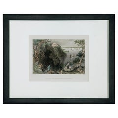
The present print is one of several examples produced for Nathaniel Currier by his longtime collaborator Frances F. "Fanny" Palmer. Harry T. Peters wrote of her: "There is no more interesting and appealing character among the group of artists who worked for Currier & Ives than Fanny Palmer. In an age when women, well-bred women in particular, did not generally work for a living Fanny Palmer for years did exacting, full-time work in order to support a large and dependent family ... Her work ... had great charm, homeliness, and a conscientious attention to detail."
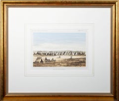
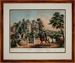
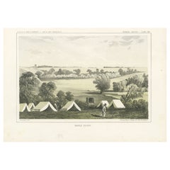
One of a series of four prints showing American country life in different seasons, the image presents the viewer with a picturesque view of a successful American farm. In the foreground, a gentleman rides a horse with a young boy before a respectable Italianate country house. Two women and a young girl pick flowers in the garden and several farm workers attend to their duties. Beyond are other homes and a city on the coast.
16.63 x 23.75 inches, artwork
28.13 x 33.38 inches, frame
Entitled bottom center "American Country Life - May Morning"
Signed in the stone, lower left "F.F. Palmer, Del."
Signed in the stone, lower right "Lith. by N. Currier"
Copyrighted lower center "Entered according to Act of Congress in the year 1855 by N. Currier in the Clerk's office of the Southern District of N.Y."
Inscribed bottom center "New York, Published by N. Currier 152 Nassau Street"
Framed to conservation standards using silk-lined 100 percent rag matting and Museum Glass with a gold gilded liner, all housed in a stained wood moulding.
Nathaniel Currier was a tall introspective man with a melancholy nature. He could captivate people with his piercing stare or charm them with his sparkling blue eyes. Nathaniel was born in Roxbury, Massachusetts on March 27th, 1813, the second of four children. His parents, Nathaniel and Hannah Currier, were distant cousins who lived a humble yet spartan life. When Nathaniel was eight years old, tragedy struck. Nathaniel’s father unexpectedly passed away leaving Nathaniel and his eleven-year-old brother Lorenzo to provide for the family. In addition to their mother, Nathaniel and Lorenzo had to care for six-year-old sister Elizabeth and two-year-old brother Charles. Nathaniel worked a series of odd jobs to support the family, and at fifteen, he started what would become a life-long career when he apprenticed in the Boston lithography shop of William and John Pendleton.
A Bavarian gentleman named Alois Senefelder invented lithography just 30 years prior to young Nat Currier’s apprenticeship. While under the employ of the brothers Pendleton, Nat was taught the art of lithography by the firm’s chief printer, a French national named Dubois, who brought the lithography trade to America.
Lithography involves grinding a piece of limestone flat and smooth then drawing in mirror image on the stone with a special grease pencil. After the image is completed, the stone is etched with a solution of aqua fortis leaving the greased areas in slight relief. Water is then used to wet the stone and greased-ink is rolled onto the raised areas. Since grease and water do not mix, the greased-ink is repelled by the moisture on the stone and clings to the original grease pencil lines. The stone is then placed in a press and used as a printing block to impart black on white images to paper.
In 1833, now twenty-years old and an accomplished lithographer, Nat Currier left Boston and moved to Philadelphia to do contract work for M.E.D. Brown, a noted engraver and printer. With the promise of good money, Currier hired on to help Brown prepare lithographic stones of scientific images for the American Journal of Sciences and Arts. When Nat completed the contract work in 1834, he traveled to New York City to work once again for his mentor John Pendleton, who was now operating his own shop located at 137 Broadway. Soon after the reunion, Pendleton expressed an interest in returning to Boston and offered to sell his print shop to Currier. Young Nat did not have the financial resources to buy the shop, but being the resourceful type he found another local printer by the name of Stodart. Together they bought Pendleton’s business.
The firm ‘Currier & Stodart’ specialized in "job" printing. They produced many different types of printed items, most notably music manuscripts for local publishers. By 1835, Stodart was frustrated that the business was not making enough money and he ended the partnership, taking his investment with him. With little more than some lithographic stones, and a talent for his trade, twenty-two year old Nat Currier set up shop in a temporary office at 1 Wall Street in New York City. He named his new enterprise ‘N. Currier, Lithographer’
Nathaniel continued as a job printer and duplicated everything from music sheets to architectural plans. He experimented with portraits, disaster scenes and memorial prints, and any thing that he could sell to the public from tables in front of his shop. During 1835 he produced a disaster print Ruins of the Planter's Hotel, New Orleans, which fell at two O’clock on the Morning of the 15th of May 1835, burying 50 persons, 40 of whom Escaped with their Lives. The public had a thirst for newsworthy events, and newspapers of the day did not include pictures. By producing this print, Nat gave the public a new way to “see” the news. The print sold reasonably well, an important fact that was not lost on Currier.
Nat met and married Eliza Farnsworth in 1840. He also produced a print that same year titled Awful Conflagration of the Steamboat Lexington in Long Island Sound on Monday Evening, January 18, 1840, by which melancholy occurrence over One Hundred Persons Perished. This print sold out very quickly, and Currier was approached by an enterprising publication who contracted him to print a single sheet addition of their paper, the New York Sun. This single page paper is presumed to be the first illustrated newspaper ever published.
The success of the Lexington print launched his career nationally and put him in a position to finally lift his family up. In 1841, Nat and Eliza had their first child, a son they named Edward West Currier. That same year Nat hired his twenty-one year old brother Charles and taught him the lithography trade, he also hired his artistically inclined brother Lorenzo to travel out west and make sketches of the new frontier as material for future prints. Charles worked for the firm on and off over the years, and invented a new type of lithographic crayon which he patented and named the Crayola. Lorenzo continued selling sketches to Nat for the next few years.
In 1843, Nat and Eliza had a daughter, Eliza West Currier, but tragedy struck in early 1847 when their young daughter died from a prolonged illness. Nat and Eliza were grief stricken, and Eliza, driven by despair, gave up on life and passed away just four months after her daughter’s death.
The subject of Nat Currier’s artwork changed following the death of his wife and daughter, and he produced many memorial prints and sentimental prints during the late 1840s. The memorial prints generally depicted grief stricken families posed by gravestones (the stones were left blank so the purchasers could fill in the names of the dearly departed). The sentimental prints usually depicted idealized portraits of women and children, titled with popular Christian names of the day.
Late in 1847, Nat Currier married Lura Ormsbee, a friend of the family. Lura was a self-sufficient woman, and she immediately set out to help Nat raise six-year-old Edward and get their house in order. In 1849, Lura delivered a son, Walter Black Currier, but fate dealt them a blow when young Walter died one year later. While Nat and Lura were grieving the loss of their new son, word came from San Francisco that Nat’s brother Lorenzo had also passed away from a brief illness. Nat sank deeper into his natural quiet melancholy. Friends stopped by to console the couple, and Lura began to set an extra place at their table for these unexpected guests. She continued this tradition throughout their lives.
In 1852, Charles introduced a friend, James Merritt Ives, to Nat and suggested he hire him as a bookkeeper. Jim Ives was a native New Yorker born in 1824 and raised on the grounds of Bellevue Hospital where his father was employed as superintendent. Jim was a self-trained artist and professional bookkeeper. He was also a plump and jovial man, presenting the exact opposite image of his new boss.
Jim Ives met Charles Currier through Caroline Clark, the object of Jim’s affection. Caroline’s sister Elizabeth was married to Charles, and Caroline was a close friend of the Currier family. Jim eventually proposed marriage to Caroline and solicited an introduction to Nat Currier, through Charles, in hopes of securing a more stable income to support his future wife.
Ives quickly set out to improve and modernize his new employer’s bookkeeping methods. He reorganized the firm’s sizable inventory, and used his artistic skills to streamline the firm’s production methods. By 1857, Nathaniel had become so dependent on Jims’ skills and initiative that he offered him a full partnership in the firm and appointed him general manager. The two men chose the name ‘Currier & Ives’ for the new partnership, and became close friends.
Currier & Ives produced their prints in a building at 33 Spruce Street where they occupied the third, fourth and fifth floors. The third floor was devoted to the hand operated printing presses that were built by Nat's cousin, Cyrus Currier, at his shop Cyrus Currier & Sons in Newark, NJ. The fourth floor found the artists, lithographers and the stone grinders at work. The fifth floor housed the coloring department, and was one of the earliest production lines in the country. The colorists were generally immigrant girls, mostly German, who came to America with some formal artistic training. Each colorist was responsible for adding a single color to a print. As a colorist finished applying their color, the print was passed down the line to the next colorist to add their color. The colorists worked from a master print displayed above their table, which showed where the proper colors were to be placed. At the end of the table was a touch up artist who checked the prints for quality, touching-in areas that may have been missed as it passed down the line. During the Civil War, demand for prints became so great that coloring stencils were developed to speed up production.
Although most Currier & Ives prints were colored in house, some were sent out to contract artists. The rate Currier & Ives paid these artists for coloring work was one dollar per one hundred small folios (a penny a print) and one dollar per one dozen large folios. Currier & Ives also offered uncolored prints to dealers, with instructions (included on the price list) on how to 'prepare the prints for coloring.' In addition, schools could order uncolored prints from the firm’s catalogue to use in their painting classes.
Nathaniel Currier and James Merritt Ives attracted a wide circle of friends during their years in business. Some of their more famous acquaintances included Horace Greeley, Phineas T. Barnum, and the outspoken abolitionists Rev. Henry Ward, and John Greenleaf Whittier (the latter being a cousin of Mr. Currier).
Nat Currier and Jim Ives described their business as "Publishers of Cheap and Popular Pictures" and produced many categories of prints. These included Disaster Scenes, Sentimental Images, Sports, Humor, Hunting Scenes, Politics, Religion, City and Rural Scenes, Trains, Ships, Fire Fighters, Famous Race Horses, Historical Portraits, and just about any other topic that satisfied the general public's taste. In all, the firm produced in excess of 7500 different titles, totaling over one million prints produced from 1835 to 1907.
Nat Currier retired in 1880, and signed over his share of the firm to his son Edward. Nat died eight years later at his summer home 'Lion’s Gate' in Amesbury, Massachusetts. Jim Ives remained active in the firm until his death in 1895, when his share of the firm passed to his eldest son, Chauncey.
In 1902, faced will failing health from the ravages of Tuberculosis, Edward Currier sold his share of the firm to
Chauncey Ives...