Items Similar to Birds Eye View of Cheshire Connecticut 1882 lithograph pub. by O. H. Bailey
Want more images or videos?
Request additional images or videos from the seller
1 of 13
O. H. BaileyBirds Eye View of Cheshire Connecticut 1882 lithograph pub. by O. H. Bailey1882
1882
$1,200
£898.18
€1,037.86
CA$1,664
A$1,863.89
CHF 969.02
MX$23,015.34
NOK 12,344.52
SEK 11,669.82
DKK 7,745.08
Shipping
Retrieving quote...The 1stDibs Promise:
Authenticity Guarantee,
Money-Back Guarantee,
24-Hour Cancellation
About the Item
View of Cheshire, Connecticut, 1882. Original lithograph was drawn and published by O. H. Bailey & Co. , a prominent 19th century map maker. The map shows a bird’s eye view of the town as it used to be, including street names and old landmarks. Beautifully colored historic map of Cheshire, CT in 1882. In 1840, a local woman known as "Jinny" discovered unusual stones in her yard. The stones turned out to be deposits of barium sulphate, or barytes, a mineral used in the manufacturing of paint, glass and rubber products. Barium sulphate was mined in Cheshire for the next 40 years, bringing a wave of immigration to the town from miners of the Cornwall, England mining district. Oakley Hoopes Baily ( 1843 - 1947 ) was a prominent map artist and publisher who drew 374 maps in his life time. This historic print has some damage on mid and lower right side as can be seen in the photos otherwise in good condition with fine hand coloring.
Description of details: Six inset images below the town include: Residence of Rev. Sanford J. Horton D. D.,Episcopal Academy of Connecticut, Horton Hall, Episcopal Academy of Connecticut, Bowden Hall, Episcopal Academy of Connecticut, Bronson Hall, Wallace House, Cheshire Manufacturing Co., Cheshire Brass Company.
Featured references to the following locations:
Cheshire Post Office, E. R. Brown, Post Master
West Cheshire Post Office
N. H. & N. R. R. Station
Town Hall
Episcopal Academy of Connecticut, founded 1794,
Rev. Sanford J. Horton D. D. Principal
Horton Hall
Bowden Hall
Bronson Hall
Principal's Residence
Gymnasium
Parade and Play Grounds
Public Schools
Episcopal Church
Congregational Church
Methodist Church
Catholic Church
Wallace House
Paynes Hotel
Cheshire Manufacturing Co.
Peck, Stowe & Wilcox Co.
Button Manufactory
The Academy Store, G. A. Steele, Proprietor
M. N. Chamberlin, M. D.
M. C. Doolittle, Merchant Tailor
E. R. Brown, General Merchandise
General Store
- Creator:O. H. Bailey (1843 - 1947)
- Creation Year:1882
- Dimensions:Height: 20 in (50.8 cm)Width: 23.25 in (59.06 cm)
- Medium:
- Period:
- Condition:
- Gallery Location:Paonia, CO
- Reference Number:1stDibs: LU78037225952
About the Seller
4.9
Vetted Professional Seller
Every seller passes strict standards for authenticity and reliability
Established in 1978
1stDibs seller since 2017
123 sales on 1stDibs
Typical response time: 3 hours
- ShippingRetrieving quote...Shipping from: Paonia, CO
- Return Policy
Authenticity Guarantee
In the unlikely event there’s an issue with an item’s authenticity, contact us within 1 year for a full refund. DetailsMoney-Back Guarantee
If your item is not as described, is damaged in transit, or does not arrive, contact us within 7 days for a full refund. Details24-Hour Cancellation
You have a 24-hour grace period in which to reconsider your purchase, with no questions asked.Vetted Professional Sellers
Our world-class sellers must adhere to strict standards for service and quality, maintaining the integrity of our listings.Price-Match Guarantee
If you find that a seller listed the same item for a lower price elsewhere, we’ll match it.Trusted Global Delivery
Our best-in-class carrier network provides specialized shipping options worldwide, including custom delivery.More From This Seller
View AllBird's Eye View of Glascow 1888 original wood engraving from The Graphic
Located in Paonia, CO
Bird’s Eye View of Glascow original 1888 wood engraving is from The Graphic by H.W. Brewer who was well known for his aerial views of topographical panoramas. He was also the fa...
Category
1880s Realist Landscape Prints
Materials
Woodcut

The First Meeting, Jerome Park, N. Y. , H. Schile 1873 Rare Proof before letters
Located in Paonia, CO
The First Meeting, Jerome Park, N. Y. is an original proof before letters of a hand colored lithograph published in 1873 by the prolific German American artist and publisher Henry Schile...
Category
1870s Other Art Style Animal Prints
Materials
Lithograph
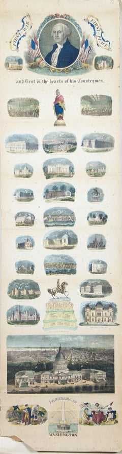
Panorama of Washington Hand- Colored Engraving pub. by Charles Magnum 1860
Located in Paonia, CO
1860 Hand -colored engraving "Panorama of Washington D. C. published by Charles Magnus This is a long sheet topped by an oval portrait of Washington...
Category
1860s Other Art Style Landscape Prints
Materials
Engraving
Map of the County of Buckingham From an Actual Survey
Located in Paonia, CO
Cartographers Christopher (1786-1855) and John (1791-1867) Greenwood were surveyors from Yorkshire, who undertook an ambitious project to produce a series of large-scale maps of the counties of England, Wales and Scotland.The maps represent a remarkable and impressive surveying achievement forming an important record of the counties depicted.
In the years 1817-1832 the Greenwood brothers published the Atlas of The Counties of England from an Actual Survey. This Atlas was finely drafted and engraved and decorated with large vignettes of prominent buildings of the county. This map of Buckingham County is beautifully hand colored and is in very good condition. There is a vignette of Stowe House...
Category
19th Century Other Art Style More Prints
Materials
Engraving

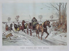
The Fiend of the Road Currier & Ives 1881 Lithograph
By Scott Leighton
Located in Paonia, CO
The Fiend of the Road shows a man in a horse driven buggy going down a country road on a winters day who has apparently left in his wake several upset horses and drivers .This original 1881 lithograph by Scott Leighton...
Category
1880s Other Art Style Animal Prints
Materials
Lithograph
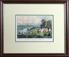
Scenery of the Upper Mississippi Indian Village Currier & Ives lithograph framed
By Currier & Ives
Located in Paonia, CO
Scenery of the Upper Mississippi Indian Village Currier & Ives lithograph is a tranquil scene of an Indian village camped in a meadow next to a be...
Category
Mid-19th Century American Realist Figurative Prints
Materials
Lithograph
You May Also Like
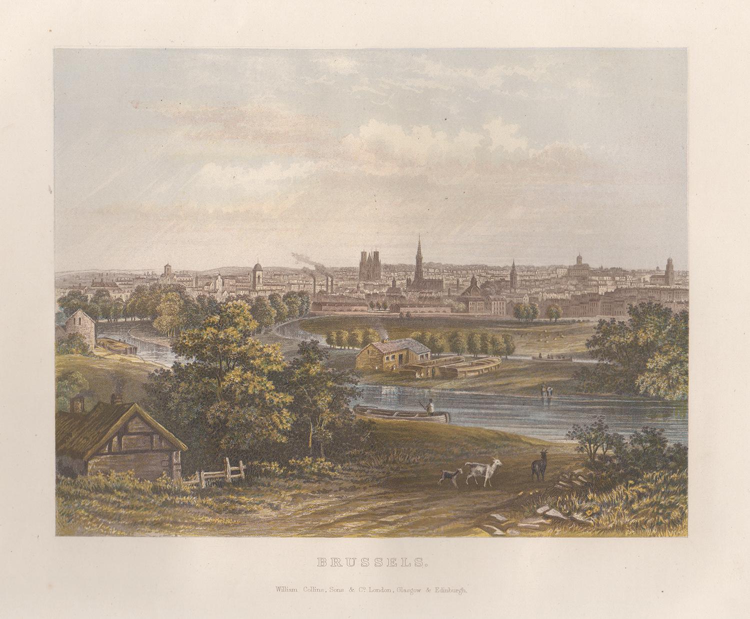
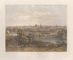
Brussels, Belgium, birds-eye view, chromolithograph, c1870
Located in Melbourne, Victoria
Brussels, Belgium, birds-eye view, chromolithograph, c1870 published by William Collins.
175mm by 225mm (image) 270mm by 335mm (sheet)
Category
Late 19th Century Naturalistic Landscape Prints
Materials
Lithograph
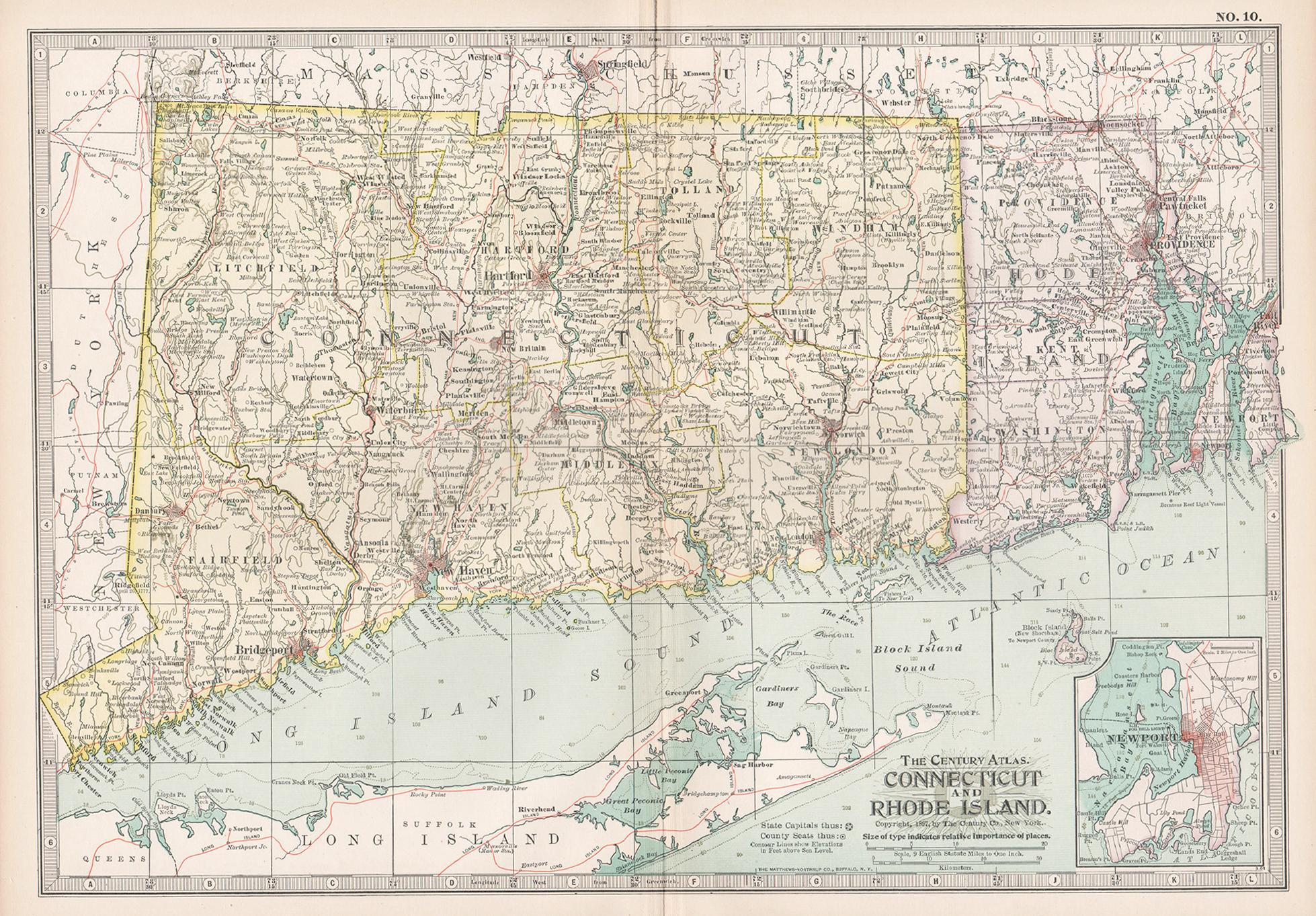
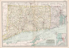
Connecticut and Rhode Island. USA. Century Atlas state antique vintage map
Located in Melbourne, Victoria
'The Century Atlas. Connecticut and Rhode Island.'
Original antique map, 1903.
Central fold as issued. Map name and number printed on the reverse corners.
Sheet 29.5cm by 40cm.
Category
Early 20th Century Victorian More Prints
Materials
Lithograph
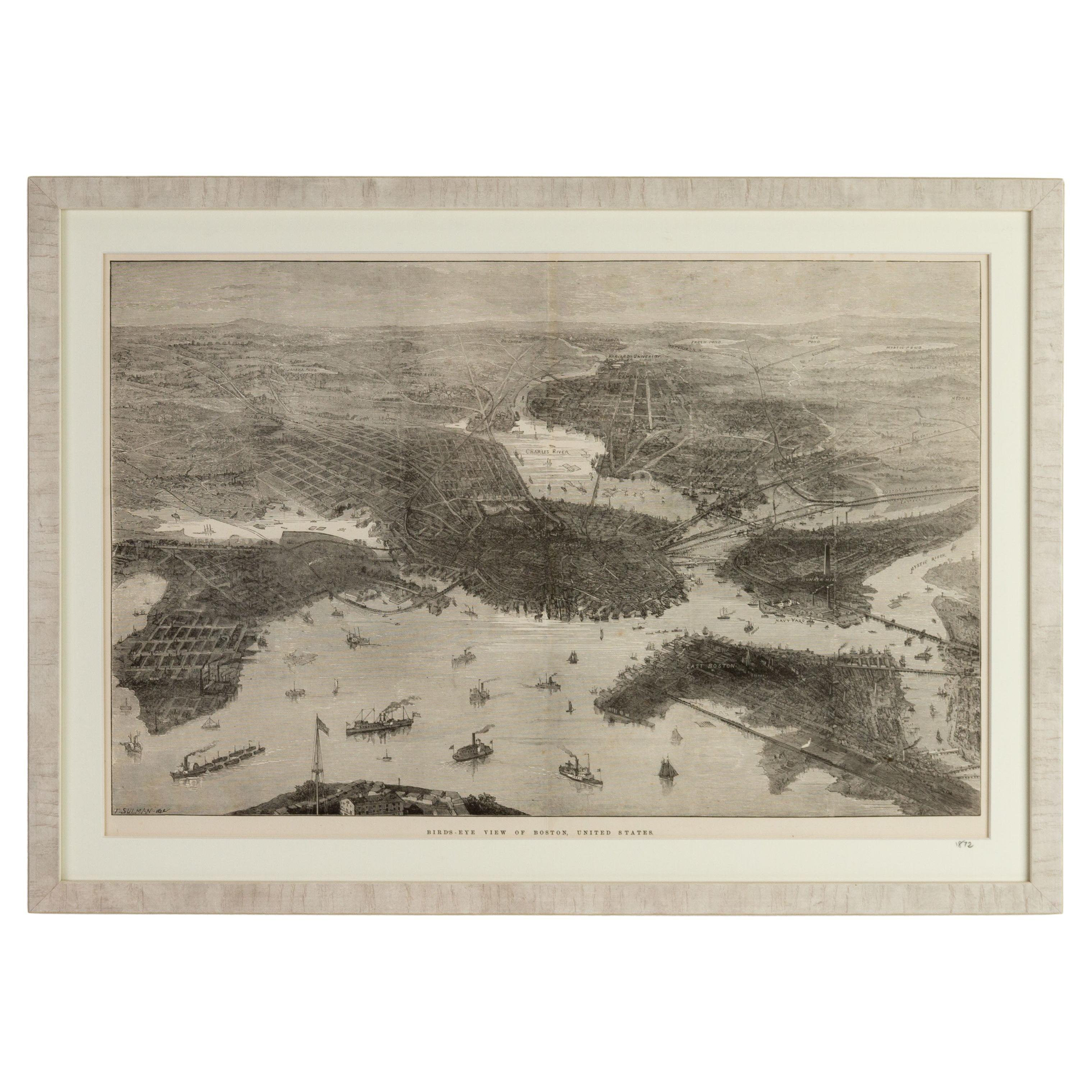
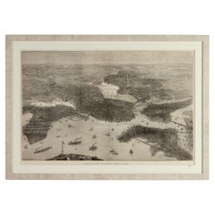
Bird's Eye View of Boston Engraving by Illustrated London News 1872
Located in Nottingham, GB
Bird's Eye View of Boston Engraving by Illustrated London News 1872.
Framed.
From a private English collection
Free international shipping
Category
Antique 1870s Prints
Materials
Paper
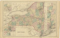
1876 Antique Map of New York State with Niagara and Hudson River Insets
Located in Langweer, NL
Title: Detailed Map of New York State - 1876 by Samuel Augustus Mitchell Jr.
Description: This is a hand-colored map of the state of New York from 1876, created by Samuel Augustus ...
Category
Antique 1870s Maps
Materials
Paper
$211 Sale Price
20% Off
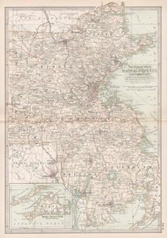
Massachusetts, Eastern Part. USA. Century Atlas state antique vintage map
Located in Melbourne, Victoria
'The Century Atlas. Massachusetts, Eastern Part'
Original antique map, 1903.
Central fold as issued. Map name and number printed on the reverse corners.
Sheet 40cm by 29.5cm.
Category
Early 20th Century Victorian More Prints
Materials
Lithograph
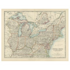
Antique Map of the Northeast USA - Vibrant 1903 Cartographic Detail
Located in Langweer, NL
Map of the Northeastern United States of North America, 1903
This striking antique map titled “United States of North America (North Eastern Sheet)” was created by the renowned Scot...
Category
Early 20th Century Maps
Materials
Paper