Items Similar to Nouvelle Mappe Monde, dediee au progres de nos connoissances.

Want more images or videos?
Request additional images or videos from the seller
1 of 11
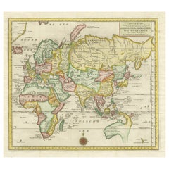
Francois SantiniNouvelle Mappe Monde, dediee au progres de nos connoissances.1784
1784
$2,350
£1,808.08
€2,066.18
CA$3,363.41
A$3,667.74
CHF 1,926.76
MX$43,960.05
NOK 24,433.20
SEK 22,737.39
DKK 15,432.11
About the Item
A handsome and well-engraved world map constructed with the prime meridian through Paris. The hemispheres are rotated through 45 degrees. This is an unusual projection for a world map and was based on the work of the French Academie Royale des Sciences. This particular impression is by Remondini who re-issued Santini's "Atlas Univ." in 1784. "Nouvelle Mappe Monde" is a copper plate engraving published by Giuseppe Remondini, Venice. The printed image size is just over 15 x 25 inches. Overall the map is in good condition with three small tears at the paper edge - all repaired. Modern (not 18th century) hand color.
Francois Santini (1729-1793) was an Italian cartographer and map published based in Venice who, in addition to creating his own work, re-issued the works of Robert de Vaugondy, Homann's Heirs, and De L'Isle.
- Creator:Francois Santini (1729 - 1793)
- Creation Year:1784
- Dimensions:Height: 20.75 in (52.71 cm)Width: 28.25 in (71.76 cm)Depth: 0.94 in (2.39 cm)
- Medium:
- Period:
- Framing:Framing Options Available
- Condition:Classic.
- Gallery Location:New York, NY
- Reference Number:Seller: 26004-21stDibs: LU33126972802
About the Seller
4.7
Recognized Seller
These prestigious sellers are industry leaders and represent the highest echelon for item quality and design.
Established in 1898
1stDibs seller since 2015
59 sales on 1stDibs
Associations
International Fine Print Dealers Association
- ShippingRetrieving quote...Shipping from: New York, NY
- Return Policy
More From This Seller
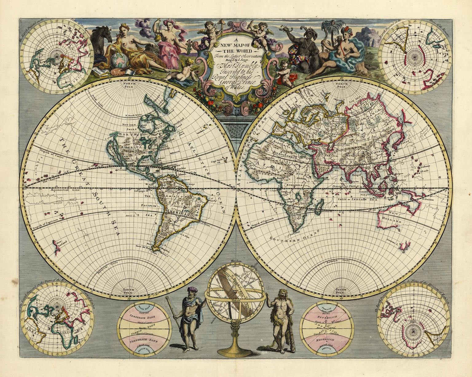
View AllA NEW MAP OF THE WORLD from the Latest Observations.
By John Senex
Located in New York, NY
The title continues “…. Most Humbly Inscribd [sic] to his Royal Highness George Prince of Wales.”
A fine British produced double hemisphere world map. On this map, California is shown as an island on the main double hemisphere map...
Category
18th Century Other Art Style More Prints
Materials
Watercolor, Engraving
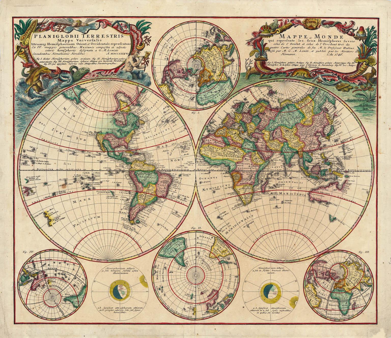
Planiglobii Terrestris Mappa Universalis / Mappe Monde
By Homann Heirs
Located in New York, NY
This map was printed from a copperplate engraving in 1746. The printed image size is 18.25 x 21.75 inches (46.3 x 55.2 cm) plus margins.
An attractive double hemisphere map...
Category
18th Century Other Art Style More Prints
Materials
Engraving

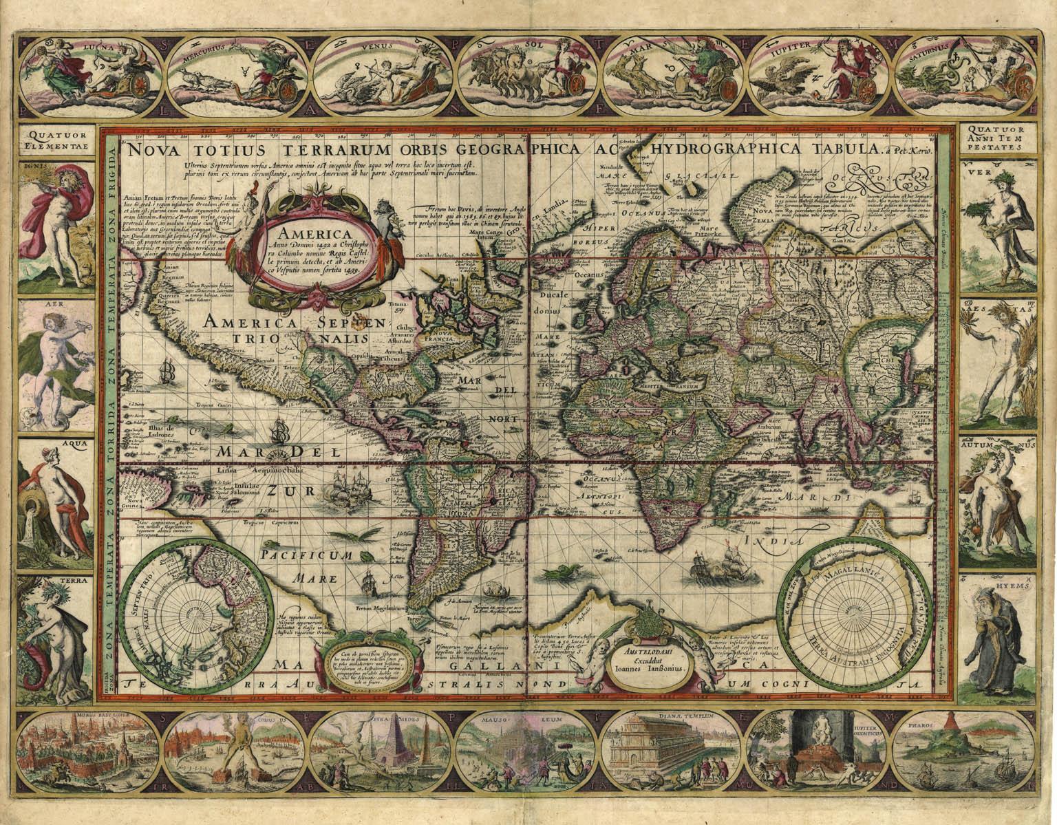
Nova Totius Terrarum Orbis Geographica Ac Hydrographica Tabula
Located in New York, NY
Copper-plate engraving, hand-colored, 1608 - c.1630 and published by Joannes Jansonius, Amsterdam. Image size 15.75 x 21.19 inches (40 x 53.9 cm).
A classic example of a world ma...
Category
17th Century Other Art Style More Art
Materials
Engraving

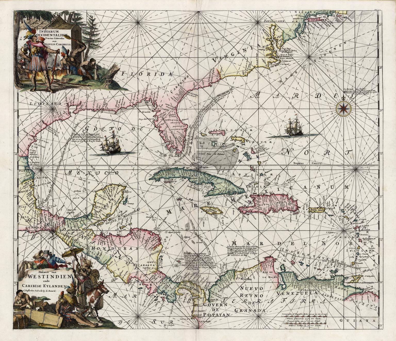
Indiarum Occidentalium Tractus Littorales cum Insulis Caribicis / Pascaert van W
By Louis Renard
Located in New York, NY
This early 18th-century engraved map was published by Louis Renard in Amsterdam. The image size is 19 x 22 " (48.3 x 55.9 cm) plus margins.
A beautifully engraved Dutch sea chart. Shown is the entire Caribbean basin including the eastern seaboard up to Cape Cod and includes Bermuda. Florida is shown with the classic flattened southeastern coast that was derived by Hessel Gerritz. Noted are the routes taken by the Spanish treasure...
Category
18th Century Other Art Style More Prints
Materials
Engraving

Interiors VI: Soundings
By Peter Milton
Located in New York, NY
Contemporary artist Peter Milton created this etching and engraving entitled "Interiors VI: Soundings" in 1989. The printed image size is 29 7/8 x 23 13/16 and paper size is 36 x 29 inches. This impression is signed, dated, and titled in pencil and inscribed “93/175” – the 93 impression of 175.
“I do love to draw. I feel that I am being granted membership in the Brotherhood of Merlin, conjuring forth some apparition. As a drawing develops, I sense a vague presence coming more and more into focus, something in a white fog emerging and becoming increasingly palpable.” – P. Milton, “The primacy of touch. The Drawings of Peter Milton”
“Working in layers, Milton begins with drawings based on people and places, with nods to Western art history and culture. He is a master of the appropriated image, a term that may conjure Andy Warhol and his Pop Art comrades. But Milton steps further back in history, avoiding the Pop sense of cool advertising and popular culture references. Instead, a broader cultural past is tapped through historical photographs of key players, architecture, and locales, which he reinvents by hand. He adds content drawn from his life as an avid reader – always with multiple possible interpretations – thus incorporating deeper meaning in his cinematic worlds. Elements of Greek mythology, classical music, art history, and history coalesce in his images, which embrace the messiness, sorrow, and elation that is life. One is hard-pressed to imagine a more erudite, skilled, passionate, and cheeky soul."
– T. L. Johnson and A. Shafer
Peter Milton was born in Pennsylvania in 1930. He studied for two years at the Virginia Military Institute...
Category
Late 20th Century Surrealist Interior Prints
Materials
Engraving, Etching
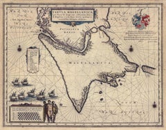
Tabula Magellanica, qua Tierra del fuego, cum celeberrimis fretis a F. Magellano
By Joan (Johannes) Blaeu
Located in New York, NY
This mid 17th-century map was published by Guiljelmum Blaeu in Amsterdam. The engraved map is 16 1/8 x 21" (41 x 53.1 cm) with beautiful original hand color. Tabula Magellanica is a highly decorative map of the southern tip of South America, including Tierra del Fuego...
Category
Mid-17th Century Other Art Style More Prints
Materials
Engraving
You May Also Like
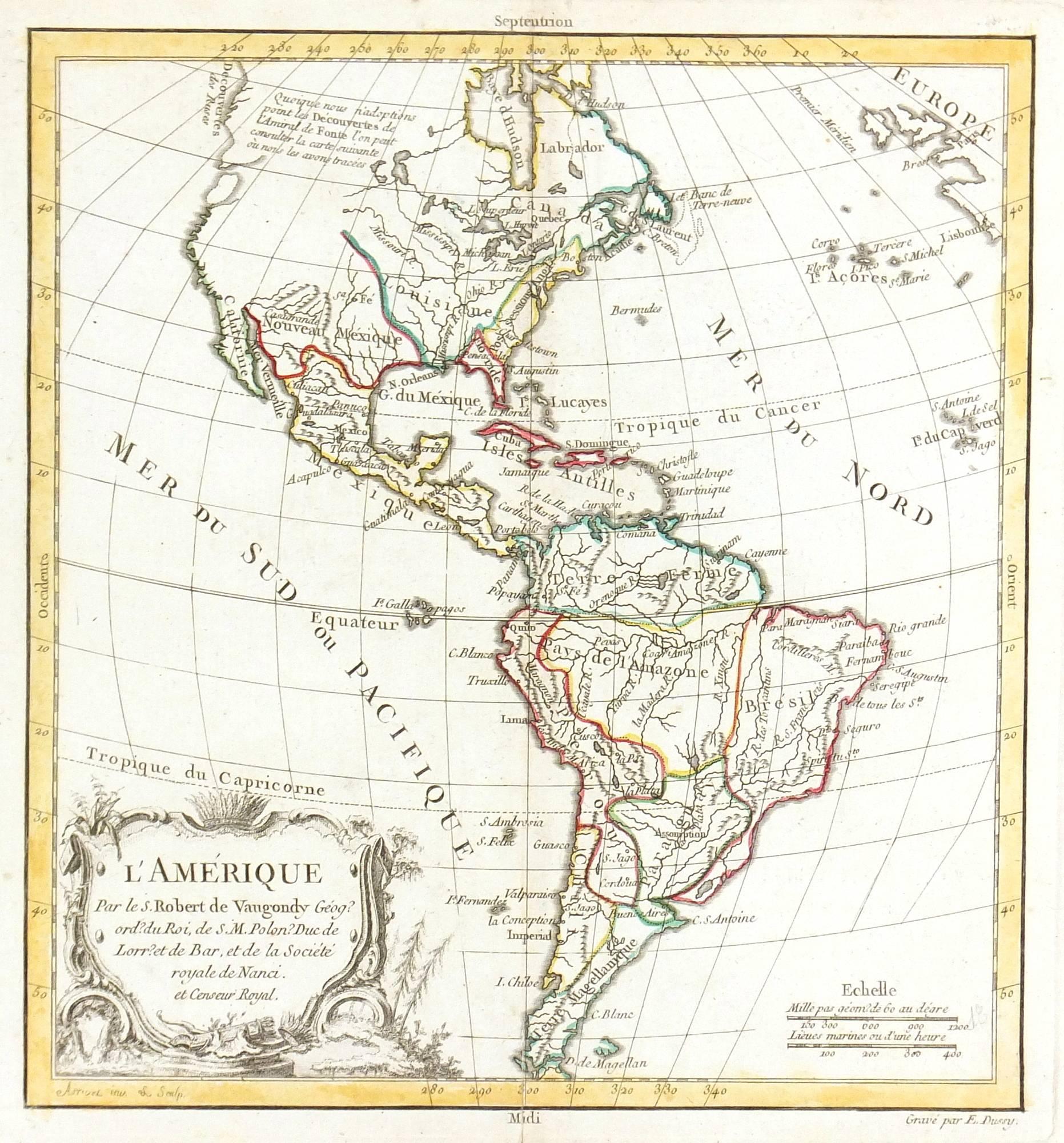
Map of Americas
Located in Houston, TX
Over 200 year old engraved map of Americas by Robert de Vaugondy from 1783. Original hand color. Shows North, Central and South Americas. Note the po...
Category
1780s More Prints
Materials
Ink, Watercolor, Handmade Paper

Antique Map of the Eastern Hemisphere by Valk & Chenk '1708'
Located in Langweer, NL
Antique map titled 'Hemispherium Orbis Antiqui, Cumzonis Circulis, Et Sity populorum Diverso'. Decorative example of Andreas Cellarius's map of the Eastern Hemisphere, illustrating with climatic zones ranging from Frigida Borealis to Torrida, with planetary details superimposed. The elaborate border includes fine scrollwork, numerous putti, and additional diagrams showing armillary spheres and climatic zones. Andreas Cellarius was born in 1596 in Neuhausen and educated in Heidelberg. He emigrated to Holland in the early 17th century and 1637 moved to Hoorn, where he became the rector of the Latin School. Cellarius' best known work is his Harmonia Macrocosmica, first issued in 1660 by Jan Jansson, as a supplement to Jansson's Atlas Novus. The work consists of a series of Celestial Charts...
Category
Antique Early 18th Century Dutch Maps
Materials
Paper

$3,993 Sale Price
25% Off
AMERICA
By John Speed
Located in Santa Monica, CA
IMPORTANT AMERICAN MAP - ONE OF THE FIRST TO SHOW CALIFORNIA as an ISLAND
JOHN SPEED (1552-1629)
AMERICA - With Those Known Parts In That Unknown Worlde (sic),
1626-(76)
(Burden 217 iv/iv) Engraving, uncolored. Engraved by Abraham Goos and
published by Thomas Basset and Richard Chiswell - 4th state of 4 in 1676
15 1/8 x 20 1/2” From “A Prospect of the Most Famous Parts of the
World”. Generally good condition. A repaired split in lower centerfold. This
is the most common version of this important map...
Category
1620s Old Masters Landscape Prints
Materials
Engraving

$4,080 Sale Price
52% Off
Interesting Original Antique Hemisphere Map Showing the Latest Discoveries
Located in Langweer, NL
Antique world map titled 'A Map of the World from the best Authorities'. Detailed map of the World, showing tracks of Captain James Cook in his 3 voyages in great detail. The map is ...
Category
Antique Late 18th Century Maps
Materials
Paper

$1,041 Sale Price
20% Off
Antique Map of the Eastern Part of the World
Located in Langweer, NL
Antique map titled 'Nieuwe Kaart van het Oostelykste Deel der Weereld, diendende tot aanwyzing van de Scheepstogten der Nederlanderen Naar Oostindie'. This finely engraved map of the...
Category
Antique Mid-18th Century Maps
Materials
Paper
Antique World Map by P. Schenk '1706'
By Peter Schenk
Located in Langweer, NL
Antique map titled 'Diversa Orbis Terrae. Visu Incedente per Coluros Tropicorum, Ambos Ejus Polos, et Parciularis Sphaerae Zenith, in Planum Orthographica Projectio (..) Plat Ontwerp van verscheyde Aert-klooten (..)'. One of the earliest Dutch World Maps to focus on a more modern cartographic style, based on Carel Allard's map of 1696. This map represented a noteworthy shift from the traditional decorative Dutch 17th century maps where the margins would be full of classical mythological...
Category
Antique Early 18th Century Maps
Materials
Paper
