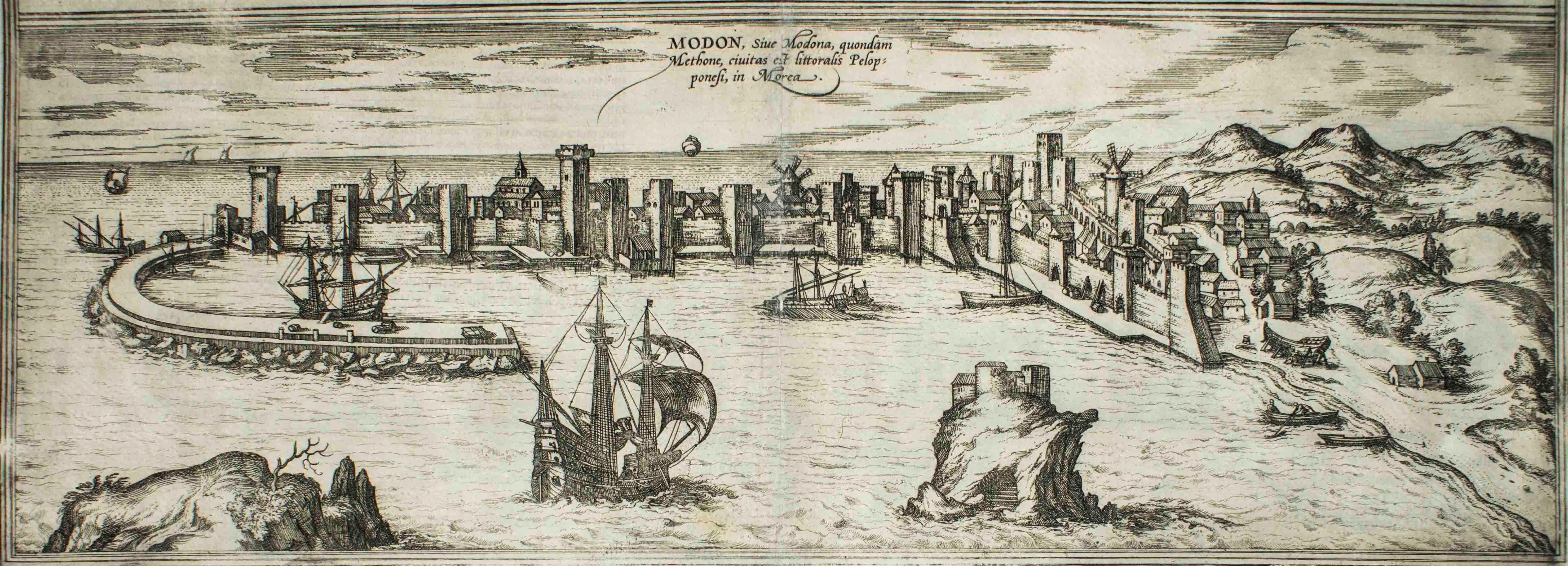
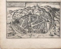
Items Similar to Map of Methoni - Etching by George Braun - Late 16th Century
Want more images or videos?
Request additional images or videos from the seller
1 of 2
George BraunMap of Methoni - Etching by George Braun - Late 16th Century16th Century
16th Century
$709.32
£540.51
€600
CA$993.62
A$1,081.81
CHF 566.42
MX$12,985.35
NOK 7,148.60
SEK 6,703.02
DKK 4,570.20
About the Item
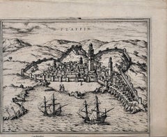
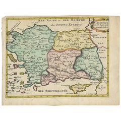
This Map of Methoni is an etching realized by George Braun (1541 – 1622)
The state of preservation of the artwork is good but aged and the trace of foxing that doesn't affect the image.
Interesting B/W etching on coeval paper,this artwork represents skilfully a detailed view of the city of Methoni through confident strokes.The title is on the plate at the top "Medon, siue. modona, quondam methone, ciuitas est littoralis pelops poneli, in Morea"
The etching belongs to the collection "Civitates Orbis Terrarurm" realized by Georg Braun and Frans Hogenberg.
The Civitates Orbis Terrarum (Atlas of the Cities of the World) was the second oldest printed atlas in the history of world cartography and the first atlas totally dedicated to topographical views. The first volume of this collection was published in Cologne in 1572; the following in 1575, 1581, 1588, and 1598. The sixth and final volume appeared in 1617, shortly before the extensive devastation wreaked by the Thirty Years’ War.
This artwork is shipped from Italy. Under existing legislation, any artwork in Italy created over 70 years ago by an artist who has died requires a licence for export regardless of the work’s market price. The shipping may require additional handling days to require the licence according to the final destination of the artwork.
- Creator:George Braun
- Creation Year:16th Century
- Dimensions:Height: 6.89 in (17.5 cm)Width: 19.1 in (48.5 cm)Depth: 0.04 in (1 mm)
- Medium:
- Period:
- Framing:Framing Options Available
- Condition:Insurance may be requested by customers as additional service, contact us for more information.
- Gallery Location:Roma, IT
- Reference Number:Seller: M-1087651stDibs: LU65036931202
About the Seller
4.9
Platinum Seller
Premium sellers with a 4.7+ rating and 24-hour response times
1stDibs seller since 2017
7,797 sales on 1stDibs
Typical response time: 1 hour
- ShippingRetrieving quote...Shipping from: Roma, Italy
- Return Policy
More From This Seller
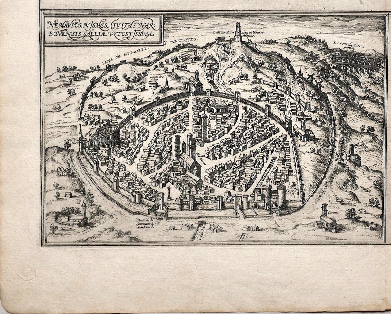
View AllMap of Nemavsus - Etching by George Braun - Late 16th Century
Located in Roma, IT
This Map of Nemavsus is an original etching realized by George Braun (1541 – 1622)
The state of preservation of the artwork is good and aged on the edges of the sheet with a few sm...
Category
16th Century More Prints
Materials
Etching
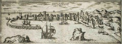
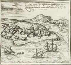
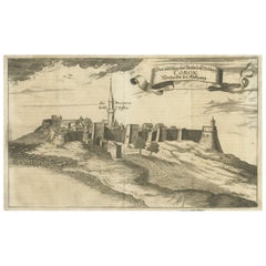
Modon, Map from "Civitates Orbis Terrarum" - by F. Hogenberg - 1575
By Franz Hogenberg
Located in Roma, IT
Modon, from the collection Civitates Orbis Terrarum, Cologne, T. Graminaeus, 1572-1617.
Good conditions.
The “Civitates Orbis Terrarum” (Atlas of Cities of the World) was the second...
Category
16th Century Figurative Prints
Materials
Etching, Aquatint
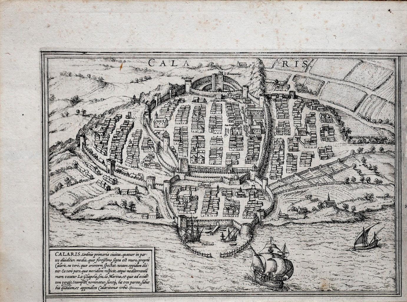
Ancient Map of Calaris - Etching by George Braun - Late 16th Century
Located in Roma, IT
Ancient Map of Calaris is an original etching belonging to the collection "Civitates Orbis Terrarurm" realized by Georg Braun and Frans Hogenberg.
The Civitates Orbis Terrarum (Atla...
Category
16th Century More Prints
Materials
Etching

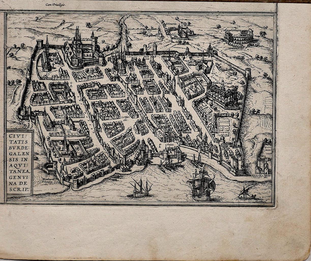
Map of Burdegalen - Original Etching by George Braun - 1575 ca.
Located in Roma, IT
This Burdegalen is an original etching realized in about 1575 by George Braun (1541 – 1622)
The state of preservation of the artwork is good and aged on the edges of the sheet with...
Category
16th Century More Prints
Materials
Etching

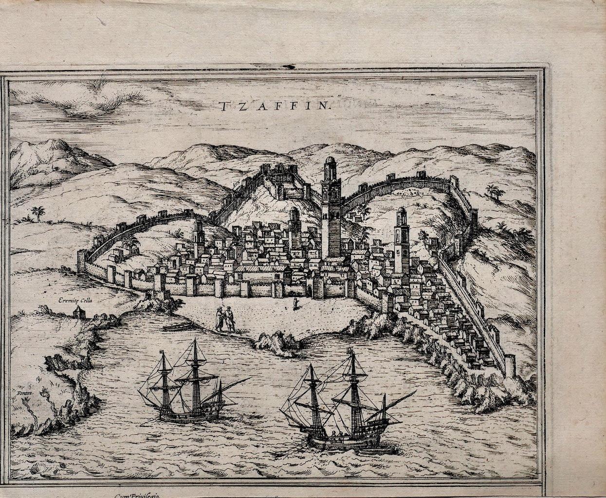
Map of Safi - Original Etching by George Braun - Late 16th Century
Located in Roma, IT
This Safi is an original etching realized by George Braun (1541 – 1622)
The state of preservation of the artwork is good.
Interesting B/W etching on coeval paper, this artwork rep...
Category
16th Century More Prints
Materials
Etching
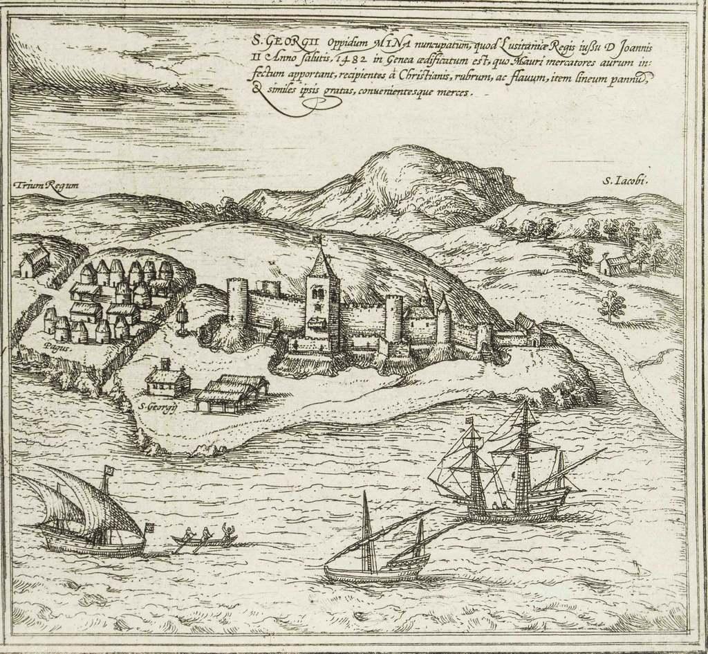
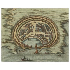
Map of San Georgi - Etching by G. Braun/F. Hogenberg - 1575
Located in Roma, IT
Etching by Georg Braun and Frans Hogenberg, realized in 1575 and belonging to the Suite "Civitates Orbis Terrarum".
The first volume of the Civitates Orbis Terrarum was published in ...
Category
16th Century Modern Figurative Prints
Materials
Etching
You May Also Like
Antique Engraving with a Plan of Rhodes, Greece, 1688
Located in Langweer, NL
Description: Antique map, titled: 'Rhodos.' - Plan of Rhodes, Greece. This map originates from 'Nauwkeurige Beschrijving der eilanden in de in de Archipel der Middellantsche Zee', by...
Category
Antique 1680s Maps
Materials
Paper
$425 Sale Price
20% Off
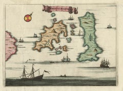
Antique Map of the Islands of Schiatti and Scopoli, Greece, 1687
Located in Langweer, NL
Antique map titled 'Schiatti - Scopoli.' This original antique map shows the islands Schiatti and Scopoli in Greece. Source unknown, to be determined.
Artists and Engravers: Made by...
Category
Antique 17th Century Maps
Materials
Paper
Antique Map of Turkey with Cyprus and Greece Islands by N. Sanson, circa 1652
Located in Langweer, NL
Antique map of Turkey, Anatolie with Cyprus and the Greece islands. Attractive scrolled title cartouche to top right corner. Blank verso.
Category
Antique Mid-17th Century Maps
Materials
Paper
Antique Map of Southern Italy by Janssonius, C.1650
Located in Langweer, NL
"Antique map titled 'Itala nam tellus Graecia Maior erat Ovid. IV. Fastor. Haec Italiae pars nunc primum de prica aerugine est abstersa (..)'. Beautiful map of Southern Italy...
Category
Antique 17th Century Maps
Materials
Paper

$699 Sale Price
20% Off
Original Copper Engraving of Koroni 'or Corone', Greece, 1688
Located in Langweer, NL
Antique print titled 'Das Aussehen der Stadt und Vestung Coron von der Seit des Auffgang'.
Copper engraving of Koroni (or Corone), Greece. This print originates from 'Ruhm-belorb...
Category
Antique 1680s Maps
Materials
Paper
$245 Sale Price
20% Off
Antique Map of the Siege of Syracuse by the Athenians, 1648 – Thucydides
Located in Langweer, NL
Antique Map of the Siege of Syracuse by the Athenians, 1648 – Thucydides
This finely engraved plan depicts the Siege of Syracuse, one of the most dramatic episodes of the Peloponnes...
Category
Antique Mid-17th Century English Maps
Materials
Paper
$699 Sale Price
20% Off