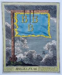
(H)ELBA FLAG


Want more images or videos?
Request additional images or videos from the seller
1 of 4
George Cruikshank(H)ELBA FLAG1815
1815
About the Item
- Creator:George Cruikshank (1792 - 1878, British)
- Creation Year:1815
- Dimensions:Height: 10 in (25.4 cm)Width: 8.25 in (20.96 cm)
- Medium:
- Movement & Style:
- Period:
- Condition:Original color, good condition. Small margins.
- Gallery Location:Santa Monica, CA
- Reference Number:1stDibs: LU41131828153
About the Seller
5.0
Recognized Seller
These prestigious sellers are industry leaders and represent the highest echelon for item quality and design.
Platinum Seller
These expertly vetted sellers are 1stDibs' most experienced sellers and are rated highest by our customers.
Established in 1977
1stDibs seller since 2016
262 sales on 1stDibs
Typical response time: 1 hour
Associations
International Fine Print Dealers Association
More From This SellerView All
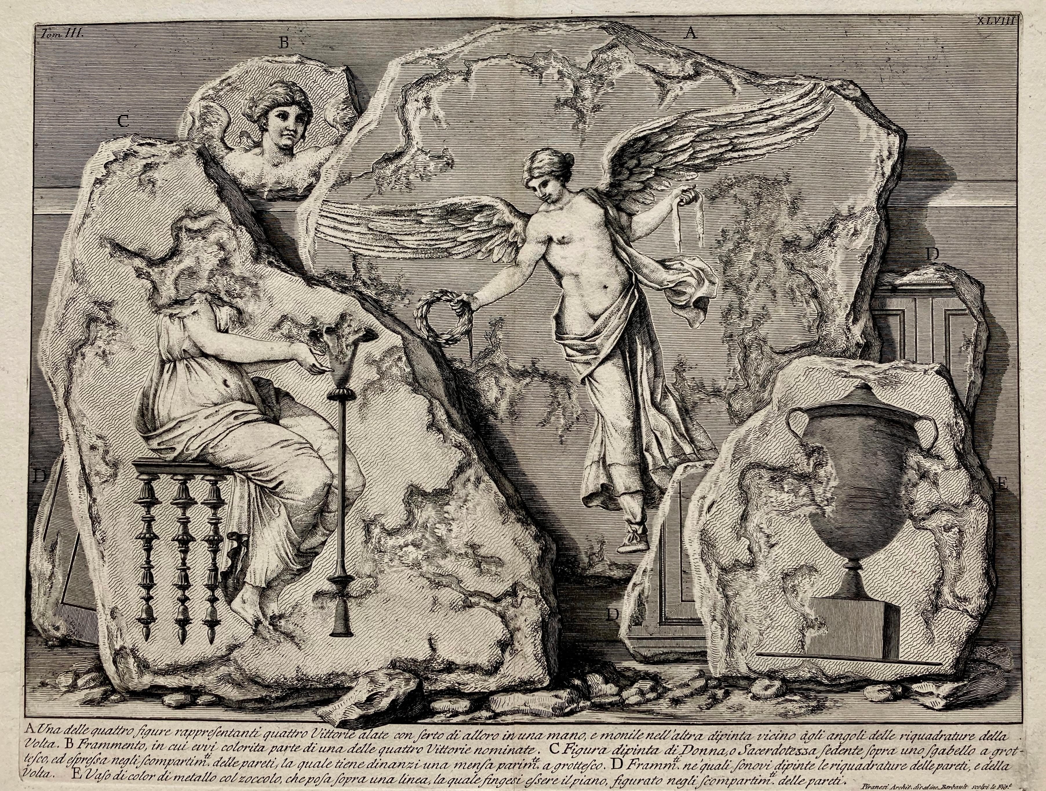
- (Large!) UNA DELLE QUATTRO FIGURE RAPPRESENTANTI QUATTRO VITTORIEBy Giovanni Battista PiranesiLocated in Santa Monica, CAGIOVANNI BATTISTA PIRANESI (1710-1778) UNA DELLE QUATTRO FIGURE RAPPRESENTANTI QUATTTRO VITTORIE, (Focillon 330, Wilton-Ely 463) 1750-1756 Etching, Plate 48 from “Le Antichita Romane“ vol. 3. Engraved by Jean Barbault...Category
1750s Old Masters More Prints
MaterialsEtching
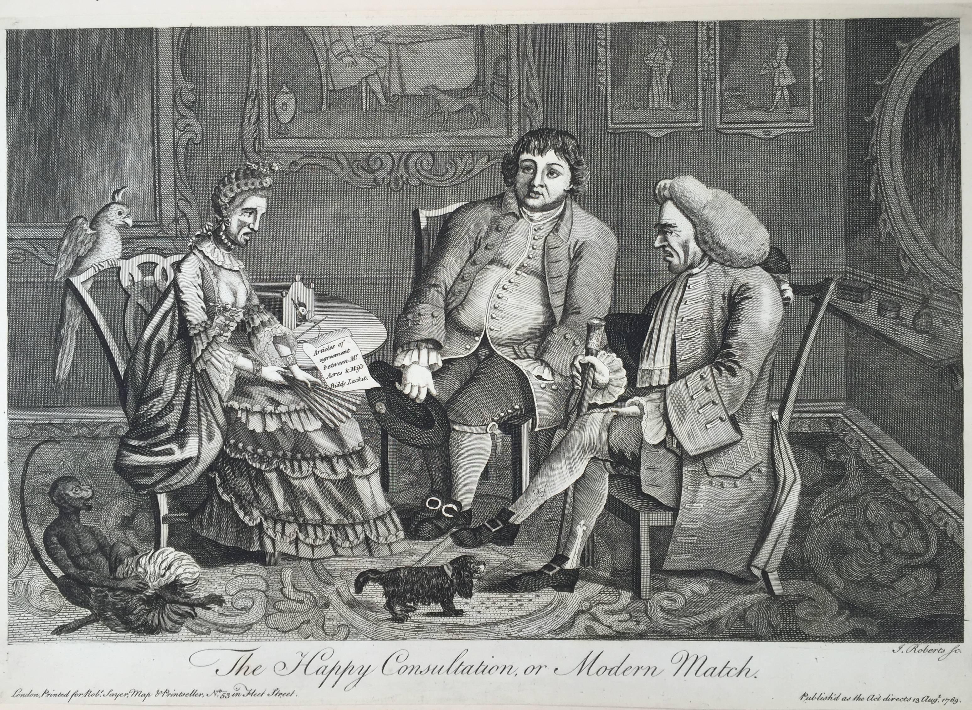
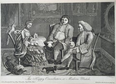
- The Happy Consultation, or Modern MatchLocated in Santa Monica, CAEIGHTEENTH CENTURY BRITISH CARICATURE THE HAPPY CONSULTATION, or MODERN MATCH, 1769 (DG 4335) ...Category
1760s Old Masters More Prints
MaterialsEngraving
 $325 Sale Price56% Off
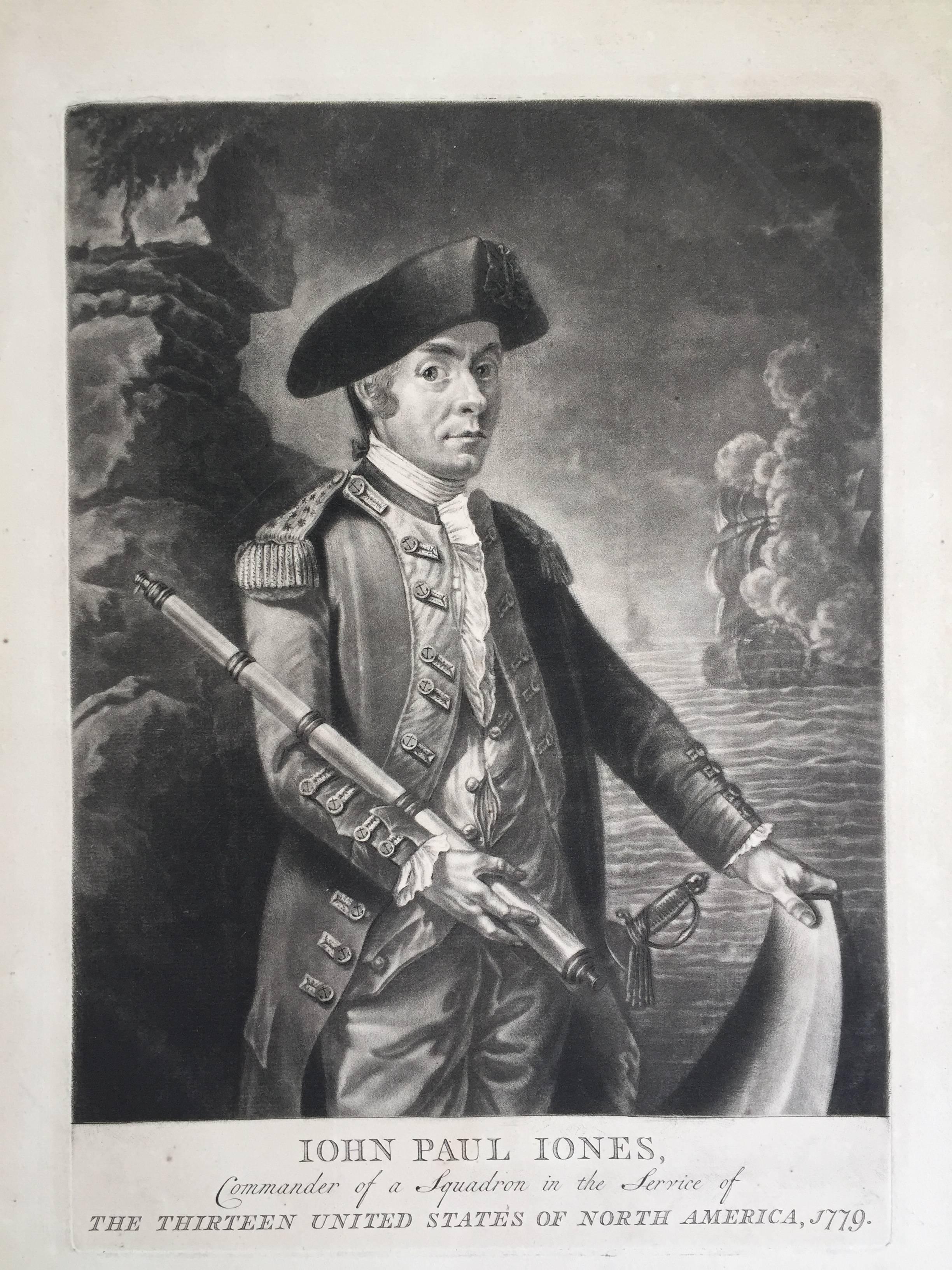
 - John Paul Jones Commander of a Squadron - 13 Colonies United States...Located in Santa Monica, CAAMERICAN REVOLUTION - (Attributed to Richard Brookshaw) JOHN PAUL JONES Commander of a Squadron in the Service of THE THIRTEEN UNITED STATES OF NORTH AMERICA, 1779 (Creswell LC1...Category
1770s Old Masters More Prints
MaterialsMezzotint
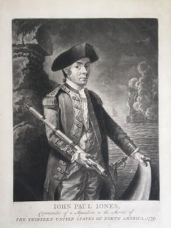 $4,250 Sale Price32% Off
 - OLD CHINATOWN - SAN FRANCISCOBy Childe HassamLocated in Santa Monica, CACHILDE HASSAM (1859 – 1935) OLD CHINATOWN - SAN FRANCISCO 1904 (Cortissoz 95 i/iii?) Etching, 5 ¼ “ x 5”. Signed and dated in the plate and with his cypher in pencil. An early state before additional work as in the example at Cornell University. Very Scarce print. On old ledger paper. Sheet 9 5/8” x 7”. Pre San Francisco earthquake. Based on a rare photograph by Arnold Genthe...Category
Early 1900s American Impressionist More Prints
MaterialsEtching
 $2,500 Sale Price33% Off
 - The Whitesmiths, Impresse des CarmelitesBy James Abbott McNeill WhistlerLocated in Santa Monica, CAJAMES ABBOTT MCNEILL WHISTLER (1834 – 1903) THE WHITESMITHS, IMPRESSE DES CARMELITES 1894 (03) Way 53, LEVY 84 Transfer lithograph signed with butterfly in stone 8 ½ x 6 1//8". ...Category
1890s Impressionist More Prints
MaterialsLithograph
 $725 Sale Price51% Off
 - Capture of Jefferson Davis in PetticoatsBy Currier & IvesLocated in Santa Monica, CACURRIER and IVES THE LAST DITCH OF THE CHIVALRY, OR THE PRESIDENT IN PETTICOATS, 1865 Lithograph published and copyright by Currier and Ives according to an act of Congress 1865. Very good impression on a nearly full sheet. Image and text 10 ¼ x 14 ¼ inches, Sheet 13 3/8 x 17 ¾ inches. Some remnants of water stain in the lower margins, 2 small tape stains at upper sheet edge. A couple other small stains in the large margins, all away the from image. (Conningham 3444). $1,100 One of the many depictions of the story of Jefferson Davis...Category
1860s Folk Art More Prints
MaterialsLithograph

You May Also Like
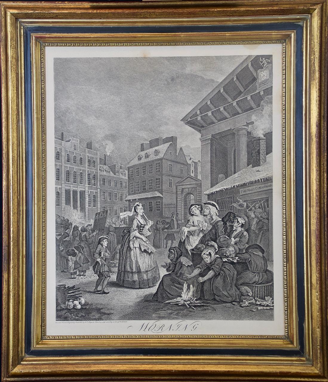
- Four Framed Hogarth Engravings "Four Times of the Day"By William HogarthLocated in Alamo, CAThe four plates in this "Four Times of the Day" set were created utilizing both engraving and etching techniques by William Hogarth in 1738. Hogarth's original copper plates were refurbished where needed by James Heath and these engravings were republished in London in 1822 by Braddock, Cradock & Joy. This was the last time Hogarth's original copper plates were used for printing. Most were melted down during World War I for the construction of bombs. Printed upon early nineteenth century wove paper and with large, full margins as published by William Heath in 1822. The inscription below each print reads "Invented Painted & Engraved by Wm. Hogarth & Publish'd March 25. 1738 according to Act of Parliament". These large folio sized "Four Times of the Day" engravings/etchings are presented in complex gold-colored wood frames with black bands and scalloped gold inner trim. A majority of each thick impressive frame is covered with glass applied near the outer edge. Each frame measures 25.75" high, 22.25" wide and 1.88" deep. There are a few small dents in the edge of these frames, which are otherwise in very good condition. "Morning" has two focal areas of discoloration in the upper margin and some discoloration in the right margin, a short tear in the left margin and a short tear or crease in the right margin. "Noon" has a spot in the upper margin that extends into the upper image, but it is otherwise in very good condition. "Evening" has a faint spot in the upper margin, but it is otherwise in very good condition. "Night" is in excellent condition. The "Four Times of the Day" series is in the collection of many major museums, including: The British Museum, The Metropolitan Museum of Art, The Tate Museum, The Chicago Art Institute and The Victoria and Albert Museum. Through this series Hogarth is portraying early 18th century London street life at "Four Times of the Day". His characters are exhibiting their personalities, quircks, strange activities, but he also wants to draw attention the disparities between the wealthy aristocracy and the common working class. Plate 1, "Morning" depicts morning in Covent Garden in the winter in front of Tom King...Category
Mid-18th Century Old Masters Landscape Prints
MaterialsEngraving, Etching
- L'Isle de France: A Hand-colored 17th Century Map by De WitBy Frederick de WitLocated in Alamo, CAThis colorful and detailed 17th century hand-colored copperplate map by Frederick De Wit was published in Amsterdam between 1666 and 1760. The map depicts the Île-de-France, which is one of the ancient provinces of France. Paris is located in the center of the map, with Versailles to the southwest The map extends from Rouen in the west to Reims in the east. The area around Paris, the Véxin Français, was the original domain of the king of France. Other areas were ruled by French feudal lords. For example, the Véxin Normand area was the domain of the Duke of Normandy...Category
Early 18th Century Old Masters More Prints
MaterialsEngraving
- Cadiz Island: A Framed 17th Century Hand-colored Map from Blaeu's Atlas MajorBy Joan (Johannes) BlaeuLocated in Alamo, CAThis is a 17th century hand-colored map entitled "Insula Gaditana Isla de Cadiz" from Johannes (Joan) Blaeu's Atlas Maior, published in Amsterdam in 1662. The map provides an excellent plan of Cadiz Island on the southwest coast of Spain, with its harbor, fortifications, agricultural fields and several surrounding salt processing areas. Numerous sailing ships of various sizes are included in and around the harbor and bay, including five large sailing ships, as well as twenty-four smaller ships. There is a small compass rose overlying the bay. The bridge to the mainland from the island is shown on the right. There is an extremely ornate and colorful title cartouche in the lower left, with its mythological figures reminiscent of Raphael’s Galatea fresco at the Villa Farnesina in Rome. The vibrant colors are vividly preserved. The master colorist tried to emulate a painting by using various tones to create a three-dimensional effect. Blaeu's name is present in the plate in the lower right. Blaeu stated in his description of Cadiz: “The main wealth of the islanders consists of salt, which they harvest, and the tuna fisheries.” This 17th century hand-colored map is framed in an ornate, partially textured bronze-colored wood frame and glazed with UV protected conservation glass. There is a vertical center fold, as issued. There is a faint crease in the lower right and faint color offset on the left from the right side of the map, resulting from having been in an atlas for hundreds of years. Small foci of paint are present in the upper portion of the left margin and in the left corner margin. The map is otherwise in very good condition. Due in large part to their powerful trade empire, the Dutch became known for cartography in the seventeenth century. This period is considered the Golden Age of Dutch cartography. Their publishing houses produced the highest quality work in Europe, particularly those maps and charts of foreign lands, and Dutch map-making set the bar for cartographic accuracy and artistry into the early-eighteenth century. Some of the most well-known cartographers worked in Amsterdam during this period. Perhaps the most famous of these was the Blaeu family. Willem Janszoon Blaeu, set up shop in Amsterdam. His son, Johannes (Joan), succeeded him upon his death in 1638, continuing in his father’s position as Hydrographer to the Dutch East India Company and selling maps to the public. The Blaeu map presses, located near Amsterdam’s Dam Square...Category
Mid-17th Century Old Masters Landscape Prints
MaterialsEngraving
- China: An Original 18th Century Hand-colored Map by E. BowenLocated in Alamo, CAThis is an original 18th century hand-colored map entitled "A New & Accurate Map of China, Drawn from Surveys made by the Jesuit Missionaries, by order of the Emperor. The whole bein...Category
Mid-18th Century Old Masters Landscape Prints
MaterialsEngraving
- Map of the World: An Original 18th Century Hand-colored Map by E. BowenLocated in Alamo, CAThis is an original 18th century hand-colored map entitled "A New & Correct Chart of All The Known World Laid down according to Mercator's Projection" by Emanuel Bowen. It was published in 1744 in London in John Harris's "Navigantium atque Itinerantium Bibliotheca" or "A Complete Collection of Voyages and Travels". This highly detailed and colorful map depicts the world. as it was known in the mid 18th century. A majority of the northern and central portions of Canada and America are left blank due to the purity of knowledge at the time this map was published. The map is embellished with four Compass Roses in the lower left, lower center, lower right and center, along with many rhumb lines. There a is a decorative title cartouche in the upper left. This colorful, attractive, historical and interesting 1744 map presents the entire world on Mercator's projection as it was understood in the middle part of the 18th century, before the landmark explorations of Captain’s Cook, Vancouver, Wilkes and others. It is an example of a nautical chart, a type of map that was designed specifically for use by mariners. The map is centered on the equator and includes both the Eastern and Western Hemispheres. The continents of North America, South America, Europe, Africa, and Asia are depicted, as well as various islands in the Atlantic, Pacific, and Indian Oceans. The map is laid out according to the Mercator projection, a type of cylindrical map projection that was developed in the 16th century by Flemish cartographer Gerardus Mercator. This projection has the advantage of preserving angles and shapes, making it useful for navigation. The map presents a paucity of inland detail, particularly for the Americas, but major cities, geographical landmarks, and regions are included. Ocean currents and Tradewinds are identified, as well as the magnetic declination lines or magnetic variance, which refers to the difference between true north and compass north. The continents are color coded, enhancing the beauty of this map. The three compass roses indicate the directions of the cardinal points. The depiction of the western coast of America, the Pacific and Australia are interesting. There was very little exploration of Australia between the navigations of William Damper in 1699 and Tobias Furneaux in 1773. Most of the maps detail relies on the 17th century Dutch expeditions to Australia's western coast, by Abel Tasman and William Janszoon. Van Diemen's Land (Tasmania) and New Guinea appear connected to the Australian continent. New Zealand appears as a single landmass. North of New Zealand there is a landmass labelled 'Ter d' St. Esprit' which probably represents the New Hebrides Islands. This map precedes the accurate exploration of the South Pacific and east coast of Australia by Captain James Cook later in the 18th century. The map includes ‘Drakes' Port,' the site where Sir Francis Drake supposedly landed in 1579 during his 1579 circumnavigation of the globe. Here he claimed territory for England, restocked, and repaired his vessels. Drake named the region New Albion. The exact location of Drake's Port is a cartographic mystery. Drake's Harbor is believed to be in the region of San Francisco Bay, Bodega Bay, San Pablo Bay...Category
Mid-18th Century Old Masters Landscape Prints
MaterialsEngraving
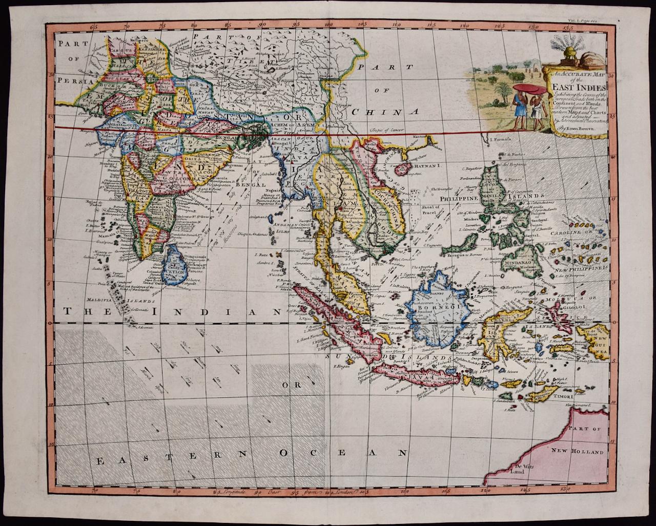
- Map of the East Indies: An Original 18th Century Hand-colored Map by E. BowenLocated in Alamo, CAThis is an original 18th century hand-colored map entitled "An Accurate Map of the East Indies Exhibiting the Course of the European Trade both on the Continent and Islands" by Emanu...Category
Mid-18th Century Old Masters Landscape Prints
MaterialsEngraving


