Items Similar to Henri Liebaux and Guillaume De L'Isle - 1706 Engraving, Map Of The Moscovites


Want more images or videos?
Request additional images or videos from the seller
1 of 9
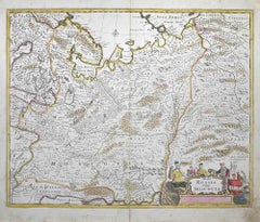
Henri Liebaux and Guillaume De L'IsleHenri Liebaux and Guillaume De L'Isle - 1706 Engraving, Map Of The Moscovites1706
1706
$274.40
$34320% Off
£210.35
£262.9320% Off
€240.76
€300.9520% Off
CA$391.97
CA$489.9620% Off
A$429.87
A$537.3420% Off
CHF 222.64
CHF 278.3020% Off
MX$5,165.22
MX$6,456.5320% Off
NOK 2,803.60
NOK 3,504.5020% Off
SEK 2,631.26
SEK 3,289.0720% Off
DKK 1,798.70
DKK 2,248.3820% Off
About the Item
A early 18th Century map showing a section of Muscovite Russia. This is the lower half of the complete original map, finished with hand colouring. The artist's names are engraved in plate at the lower left underneath the scale bar. On laid.
- Creator:Henri Liebaux and Guillaume De L'Isle
- Creation Year:1706
- Dimensions:Height: 21.26 in (54 cm)Width: 29.73 in (75.5 cm)
- Medium:
- Period:
- Condition:The condition is typical for a picture of this age including some discolouration. The original plate lines are in tact. There is a crease down the centre from being folded in storage.
- Gallery Location:Corsham, GB
- Reference Number:Seller: rd1191stDibs: LU881311100352
About the Seller
4.9
Platinum Seller
Premium sellers with a 4.7+ rating and 24-hour response times
Established in 2010
1stDibs seller since 2018
1,393 sales on 1stDibs
Typical response time: 2 hours
- ShippingRetrieving quote...Shipping from: Corsham, United Kingdom
- Return Policy
Authenticity Guarantee
In the unlikely event there’s an issue with an item’s authenticity, contact us within 1 year for a full refund. DetailsMoney-Back Guarantee
If your item is not as described, is damaged in transit, or does not arrive, contact us within 7 days for a full refund. Details24-Hour Cancellation
You have a 24-hour grace period in which to reconsider your purchase, with no questions asked.Vetted Professional Sellers
Our world-class sellers must adhere to strict standards for service and quality, maintaining the integrity of our listings.Price-Match Guarantee
If you find that a seller listed the same item for a lower price elsewhere, we’ll match it.Trusted Global Delivery
Our best-in-class carrier network provides specialized shipping options worldwide, including custom delivery.More From This Seller
View All18th Century Map Engraving - Mechlin, or Malines
Located in Corsham, GB
A map of Mechelen, known as Malines in French and Mechlin in English, a city and municipality in the province of Antwerp in the Flemish Region of Belgium. A birds-eye view plan of th...
Category
18th Century More Prints
Materials
Engraving

$269 Sale Price
20% Off
18th Century Map Engraving - Newport, a Strong Sea-Port Town in Flanders
Located in Corsham, GB
A map of Nieuwpoort, anglicised to 'Newport', in northern Belgium. There is a panorama in the upper quarter depicting major landmarks. Below is a plan of the town, including its strong defences and ships at the port in the lower register. Inscribed with the title in plate to the lower edge, 'Newport a Strong Sea-Port Town...
Category
18th Century More Prints
Materials
Engraving

$269 Sale Price
20% Off
John Senex (1678-1740) - 18th Century Engraving, A New Map of Great Britain
By John Senex
Located in Corsham, GB
A New Map of Great Britain - Corrected from the Observations Communicated to the Royal Society at London. By John Senex F.R.S. A double-page engraved map on 2 sheets joined, with lat...
Category
18th Century More Prints
Materials
Engraving

18th Century Map Engraving - Plan of the Works of the City of Messina, Sicily
Located in Corsham, GB
A map of Messina, a harbour city in northeast Sicily. Inscribed with the title in plate to the lower edge, 'Plan of the Works of the City of Messina, one of the strongest and most co...
Category
18th Century More Prints
Materials
Engraving

$285 Sale Price
20% Off
After Johann B. Homann (1664-1724) - 19th C, General Map of Spain and Portugal
Located in Corsham, GB
General map of Spain and Portugal divided into its current provinces by D.T. Lopez, newly drawn by F. L. G. in Nuremberg at the Heret of Homann, 1782. A double-page engraved map with...
Category
19th Century More Prints
Materials
Engraving

John Thomson (1777-1840) - 1830 Map Engraving, The Rivers of the World
By John Thomson
Located in Corsham, GB
A fine engraved chart table showing the lengths of the principal rivers across the world, from the second edition of John Thomson's 'New General Atlas' published in 1830. On paper.
Category
Early 19th Century More Prints
Materials
Engraving
$349 Sale Price
20% Off
You May Also Like
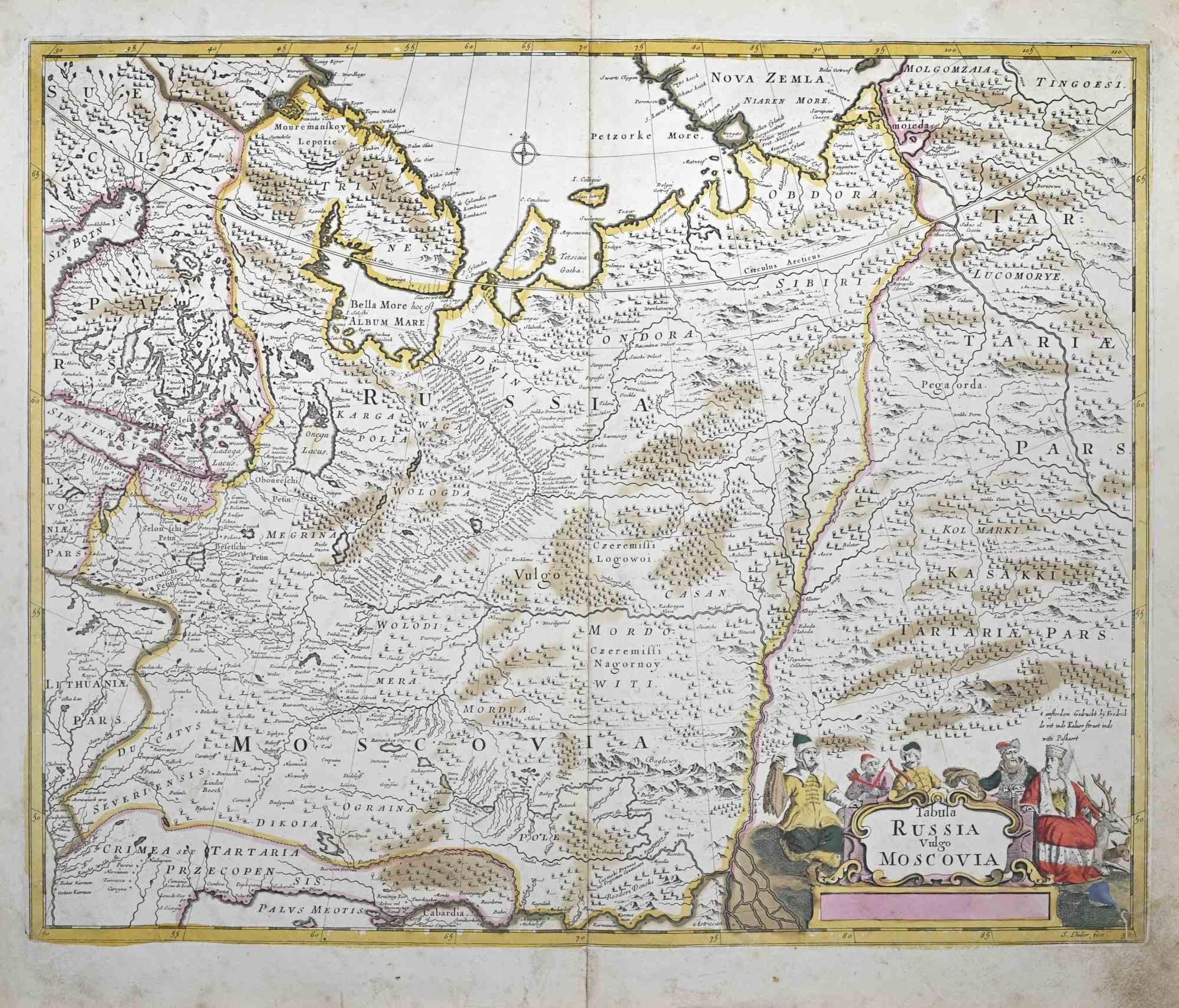
Tabula Russia Vulgo Moscovia - Etching by Frederick de Wit - 1680ca
By Frederick de Wit
Located in Roma, IT
This double-page etching with contemporary coloring, entitled Tabula Russia vulgo Moscovia, was realized by the cartographer Frederick de Wit for the famous Atlas published in Amster...
Category
1680s Modern Figurative Prints
Materials
Etching
Antique Map of the Region of Picardy by Janssonius, 1657
By Johannes Janssonius
Located in Langweer, NL
Antique map of France titled 'Picardia vera et inferior'. Detailed map of the Picardy region of France. This map originates from 'Atlas Novus, Sive Theatrum Orbis Orbis Terrarum: In ...
Category
Antique Mid-17th Century Maps
Materials
Paper

$474 Sale Price
20% Off
Antique Map of Moscovy 'Russia' by E. Bowen, 1747
Located in Langweer, NL
Beautiful map of European Russia by the English cartographer Emmanuel Bowen. It depicts the European portion of Russia extending from the Gulf of Finland to the Ural Mountains. The m...
Category
Antique Mid-18th Century Maps
Materials
Paper

Decorative Antique Map of Austria – Frederick de Wit, Amsterdam c.1690
Located in Langweer, NL
Antique Map of Austria – “Circuli Austriaci pars Septentrionalis” by F. de Wit, c.1670
This finely engraved map, titled “Circuli Austriaci pars Septent...
Category
Antique Late 17th Century Dutch Maps
Materials
Paper

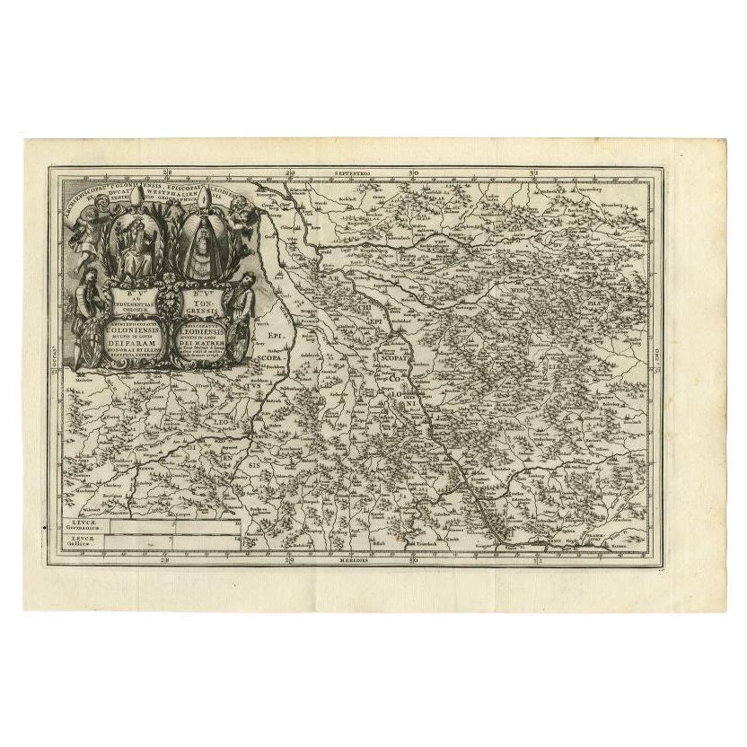
Antique Map of the Region of Cologne and Liege by Scherer, 1699
Located in Langweer, NL
Antique map titled 'Archpiescopatus Coloniensis (..) Episcopatus Leodiensis (..).' Detailed uncommon map of the Archbishopric of Cologne and the Bishopric of Liege/Luik. Source unkno...
Category
Antique 17th Century Maps
Materials
Paper
$213 Sale Price
20% Off
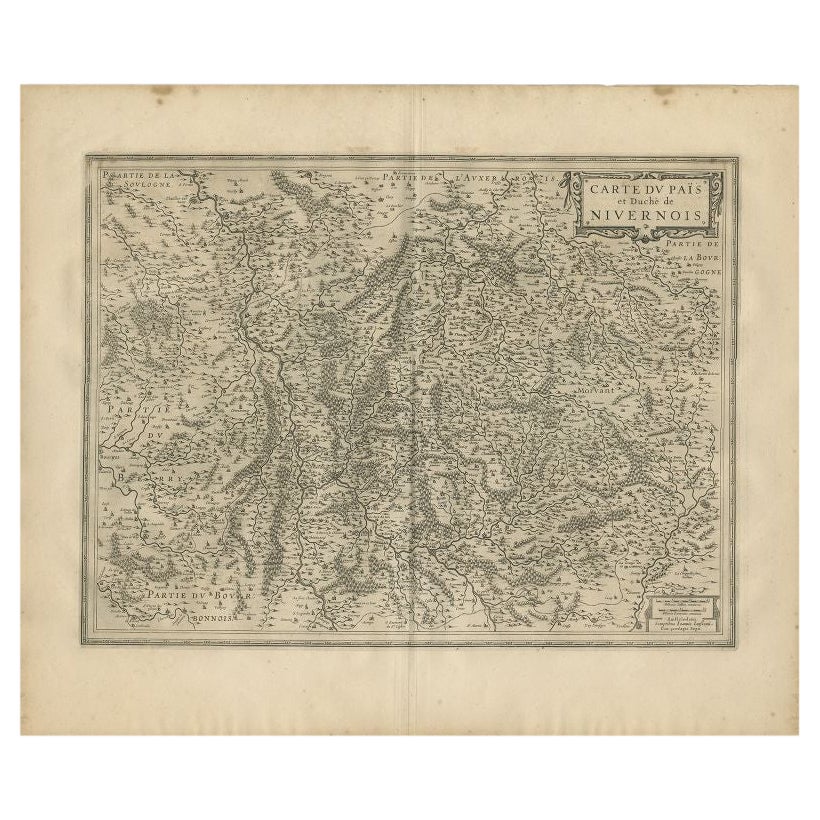
Antique Map of the Region of Nivernais by Janssonius, 1657
By Johannes Janssonius
Located in Langweer, NL
Antique map of France titled 'Carte du Païs et Duché de Nivernois'. Decorative map of the Nivernais region, part of Burgundy, France. This map originates from 'Atlas Novus, Sive Thea...
Category
Antique 17th Century Maps
Materials
Paper

$369 Sale Price
20% Off
More Ways To Browse
Antique Name Plate
Artist Proof Shepard Fairey
Blue Star Line
Christopher Wool The Show Is Over
Cordial Campari
Dali Romeo Juliet
Folon Poster
Invader Map
Jacques Pecnard
Memories Of Surrealism
Motor Racing Art
Osvaldo Peruzzi
Picasso Pan
Wash Art Print 1979
Zhiyong Jing
A La Place Clichy
Alton Kelley
Andy Warhol Tomato Soup