Items Similar to Planiglobii Terrestris Mappa Universalis / Mappe Monde


Want more images or videos?
Request additional images or videos from the seller
1 of 11
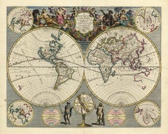
Homann HeirsPlaniglobii Terrestris Mappa Universalis / Mappe Monde1746
1746
$1,950
£1,480.43
€1,696.53
CA$2,767.77
A$3,018.93
CHF 1,585.92
MX$36,522.91
NOK 19,840.42
SEK 18,733.31
DKK 12,663.42
About the Item
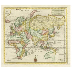
This map was printed from a copperplate engraving in 1746. The printed image size is 18.25 x 21.75 inches (46.3 x 55.2 cm) plus margins.
An attractive double hemisphere map of the world by the famous German cartographic family, Homann. The title is noted in Latin on the left and French in the right cartouche. Surrounding the main image are four additional hemispheric projections and two celestial models. The map was compiled by J. M. Haas, Professor of Mathematics at Wittenberg. This world map Includes an incomplete depiction of both the Australian continent and the island of New Zealand. There is also a fanciful view of the North West Coast of America based upon the early Russian explorations.
Johann Baptist Homann was a German engraver and publisher who established himself and his family in Nuremberg in 1702. He published his first atlas, "Atlas Novus" in 1707, and in recognition of this achievement, he was elected to the Berlin Academy of Sciences. In 1715 J. B. Homann was appointed Geographer to the Emperor. Upon his death in 1724 his business was continued by his family under the name Homann's Heirs into the late 18th century. This map is in good condition and backed on Japan paper.
- Creator:Homann Heirs (German)
- Creation Year:1746
- Dimensions:Height: 20.13 in (51.14 cm)Width: 23.88 in (60.66 cm)Depth: 0.94 in (2.39 cm)
- Medium:
- Period:
- Condition:
- Gallery Location:New York, NY
- Reference Number:Seller: #427231stDibs: LU33126980762
About the Seller
4.7
Recognized Seller
These prestigious sellers are industry leaders and represent the highest echelon for item quality and design.
Established in 1898
1stDibs seller since 2015
58 sales on 1stDibs
Typical response time: 1 to 2 days
Associations
International Fine Print Dealers Association
- ShippingRetrieving quote...Shipping from: New York, NY
- Return Policy
Authenticity Guarantee
In the unlikely event there’s an issue with an item’s authenticity, contact us within 1 year for a full refund. DetailsMoney-Back Guarantee
If your item is not as described, is damaged in transit, or does not arrive, contact us within 7 days for a full refund. Details24-Hour Cancellation
You have a 24-hour grace period in which to reconsider your purchase, with no questions asked.Vetted Professional Sellers
Our world-class sellers must adhere to strict standards for service and quality, maintaining the integrity of our listings.Price-Match Guarantee
If you find that a seller listed the same item for a lower price elsewhere, we’ll match it.Trusted Global Delivery
Our best-in-class carrier network provides specialized shipping options worldwide, including custom delivery.More From This Seller
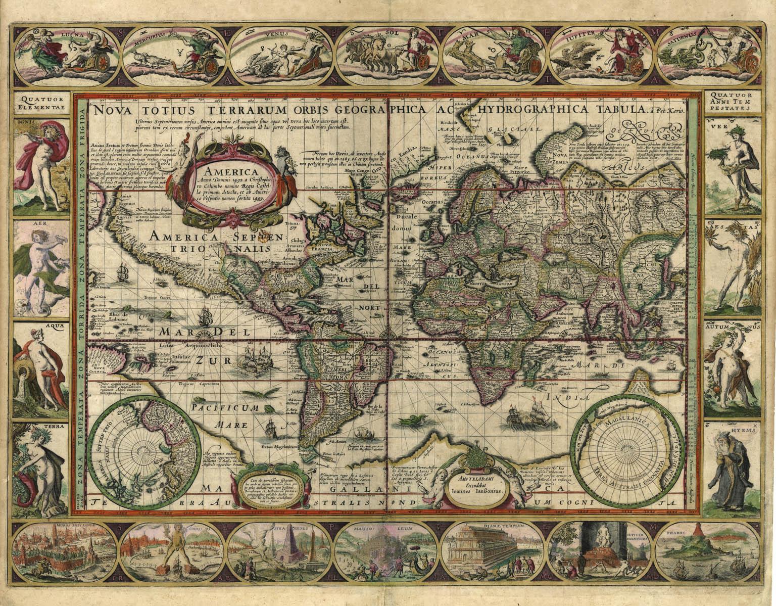
View AllNova Totius Terrarum Orbis Geographica Ac Hydrographica Tabula
Located in New York, NY
Copper-plate engraving, hand-colored, 1608 - c.1630 and published by Joannes Jansonius, Amsterdam. Image size 15.75 x 21.19 inches (40 x 53.9 cm).
A classic example of a world ma...
Category
17th Century Other Art Style More Art
Materials
Engraving

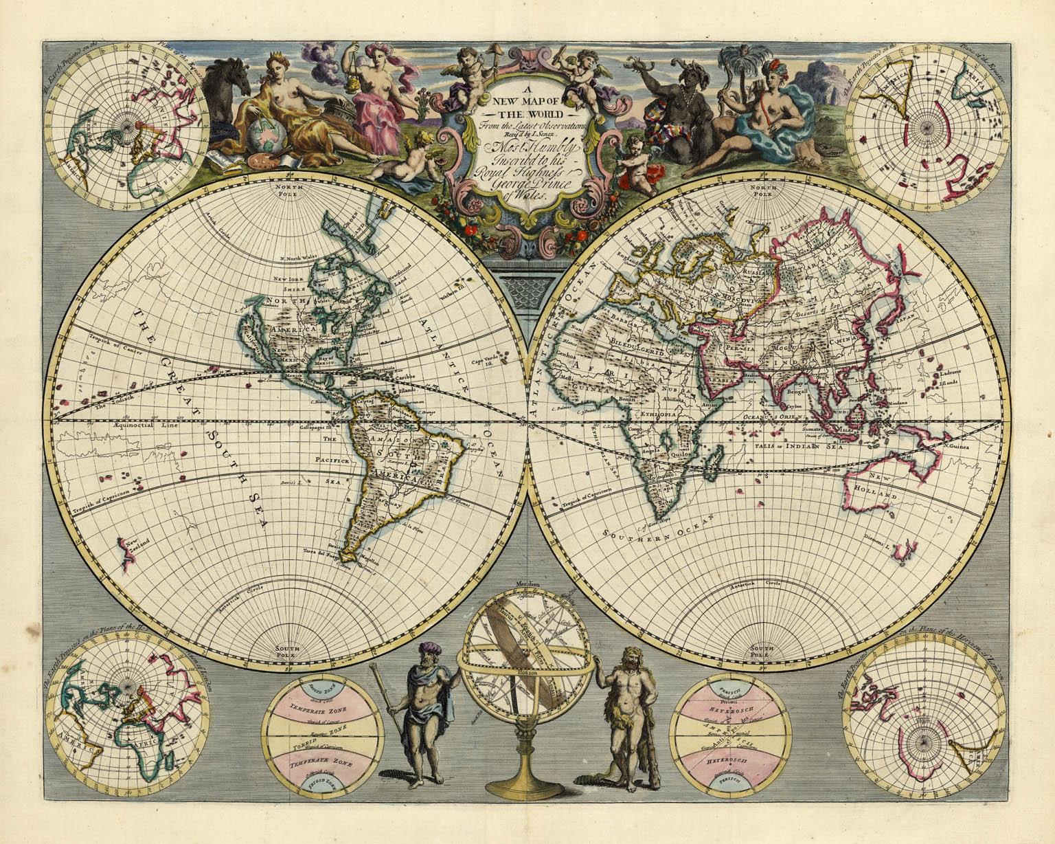
A NEW MAP OF THE WORLD from the Latest Observations.
By John Senex
Located in New York, NY
The title continues “…. Most Humbly Inscribd [sic] to his Royal Highness George Prince of Wales.”
A fine British produced double hemisphere world map. On this map, California is shown as an island on the main double hemisphere map...
Category
18th Century Other Art Style More Prints
Materials
Watercolor, Engraving
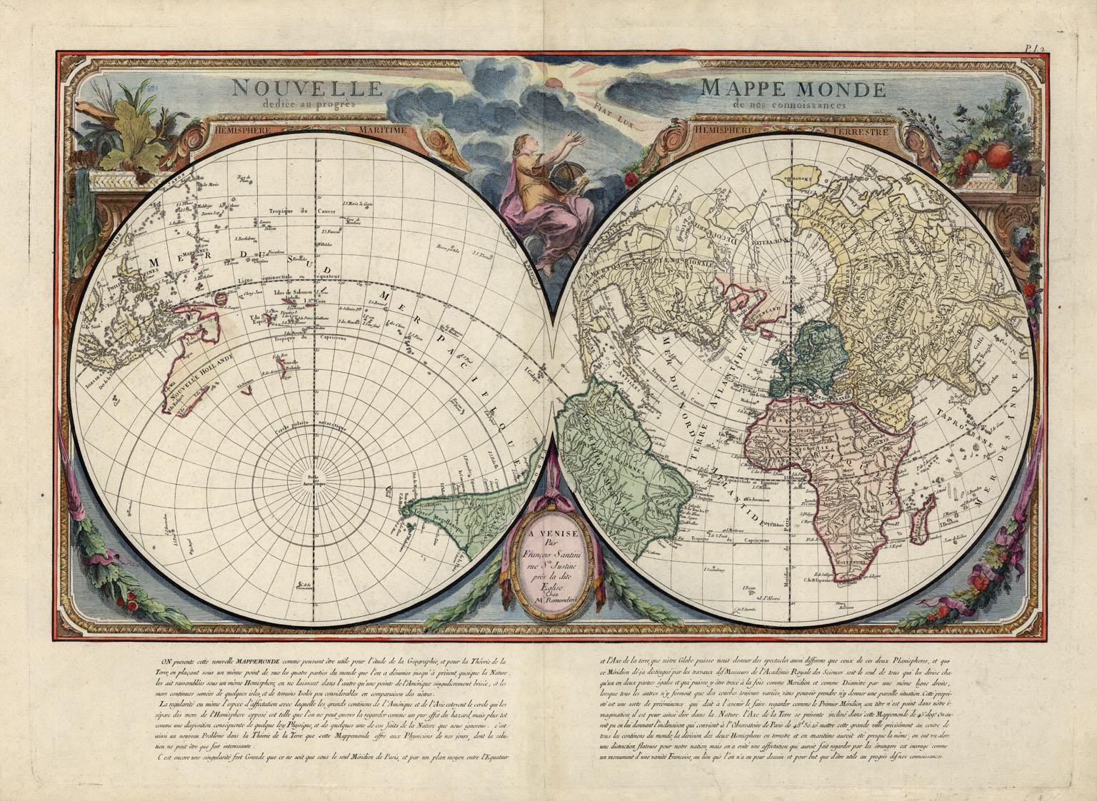
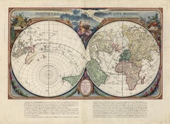
Nouvelle Mappe Monde, dediee au progres de nos connoissances.
Located in New York, NY
A handsome and well-engraved world map constructed with the prime meridian through Paris. The hemispheres are rotated through 45 degrees. This is an unusual projection for a world map and was based on the work of the French Academie Royale des Sciences. This particular impression is by Remondini who re-issued Santini's "Atlas Univ." in 1784. "Nouvelle Mappe Monde" is a copper plate engraving published by Giuseppe Remondini, Venice. The printed image size is just over 15 x 25 inches. Overall the map is in good condition with three small tears at the paper edge - all repaired. Modern (not 18th...
Category
18th Century Other Art Style More Prints
Materials
Watercolor, Engraving
Indiarum Occidentalium Tractus Littorales cum Insulis Caribicis / Pascaert van W
By Louis Renard
Located in New York, NY
This early 18th-century engraved map was published by Louis Renard in Amsterdam. The image size is 19 x 22 " (48.3 x 55.9 cm) plus margins.
A beautifully engraved Dutch sea chart. Shown is the entire Caribbean basin including the eastern seaboard up to Cape Cod and includes Bermuda. Florida is shown with the classic flattened southeastern coast that was derived by Hessel Gerritz. Noted are the routes taken by the Spanish treasure...
Category
18th Century Other Art Style More Prints
Materials
Engraving

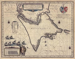
Tabula Magellanica, qua Tierra del fuego, cum celeberrimis fretis a F. Magellano
By Joan (Johannes) Blaeu
Located in New York, NY
This mid 17th-century map was published by Guiljelmum Blaeu in Amsterdam. The engraved map is 16 1/8 x 21" (41 x 53.1 cm) with beautiful original hand color. Tabula Magellanica is a highly decorative map of the southern tip of South America, including Tierra del Fuego...
Category
Mid-17th Century Other Art Style More Prints
Materials
Engraving
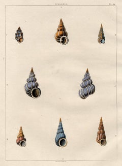
Scalaria. Univalves.
By George Perry
Located in New York, NY
This early 19th-century aquatint was engraved and colored by Mr. John Clarke after drawings by George Perry. The publication, CONCHOLOGY, OR, THE NATURAL HISTORY OF SHELLS… , was pub...
Category
Early 19th Century Naturalistic More Prints
Materials
Aquatint
You May Also Like
Antique Map of the Eastern Hemisphere by Valk & Chenk '1708'
Located in Langweer, NL
Antique map titled 'Hemispherium Orbis Antiqui, Cumzonis Circulis, Et Sity populorum Diverso'. Decorative example of Andreas Cellarius's map of the Eastern Hemisphere, illustrating with climatic zones ranging from Frigida Borealis to Torrida, with planetary details superimposed. The elaborate border includes fine scrollwork, numerous putti, and additional diagrams showing armillary spheres and climatic zones. Andreas Cellarius was born in 1596 in Neuhausen and educated in Heidelberg. He emigrated to Holland in the early 17th century and 1637 moved to Hoorn, where he became the rector of the Latin School. Cellarius' best known work is his Harmonia Macrocosmica, first issued in 1660 by Jan Jansson, as a supplement to Jansson's Atlas Novus. The work consists of a series of Celestial Charts...
Category
Antique Early 18th Century Dutch Maps
Materials
Paper

$4,035 Sale Price
25% Off
Antique World Map by P. Schenk '1706'
By Peter Schenk
Located in Langweer, NL
Antique map titled 'Diversa Orbis Terrae. Visu Incedente per Coluros Tropicorum, Ambos Ejus Polos, et Parciularis Sphaerae Zenith, in Planum Orthographica Projectio (..) Plat Ontwerp van verscheyde Aert-klooten (..)'. One of the earliest Dutch World Maps to focus on a more modern cartographic style, based on Carel Allard's map of 1696. This map represented a noteworthy shift from the traditional decorative Dutch 17th century maps where the margins would be full of classical mythological...
Category
Antique Early 18th Century Maps
Materials
Paper

$5,166 Sale Price
20% Off
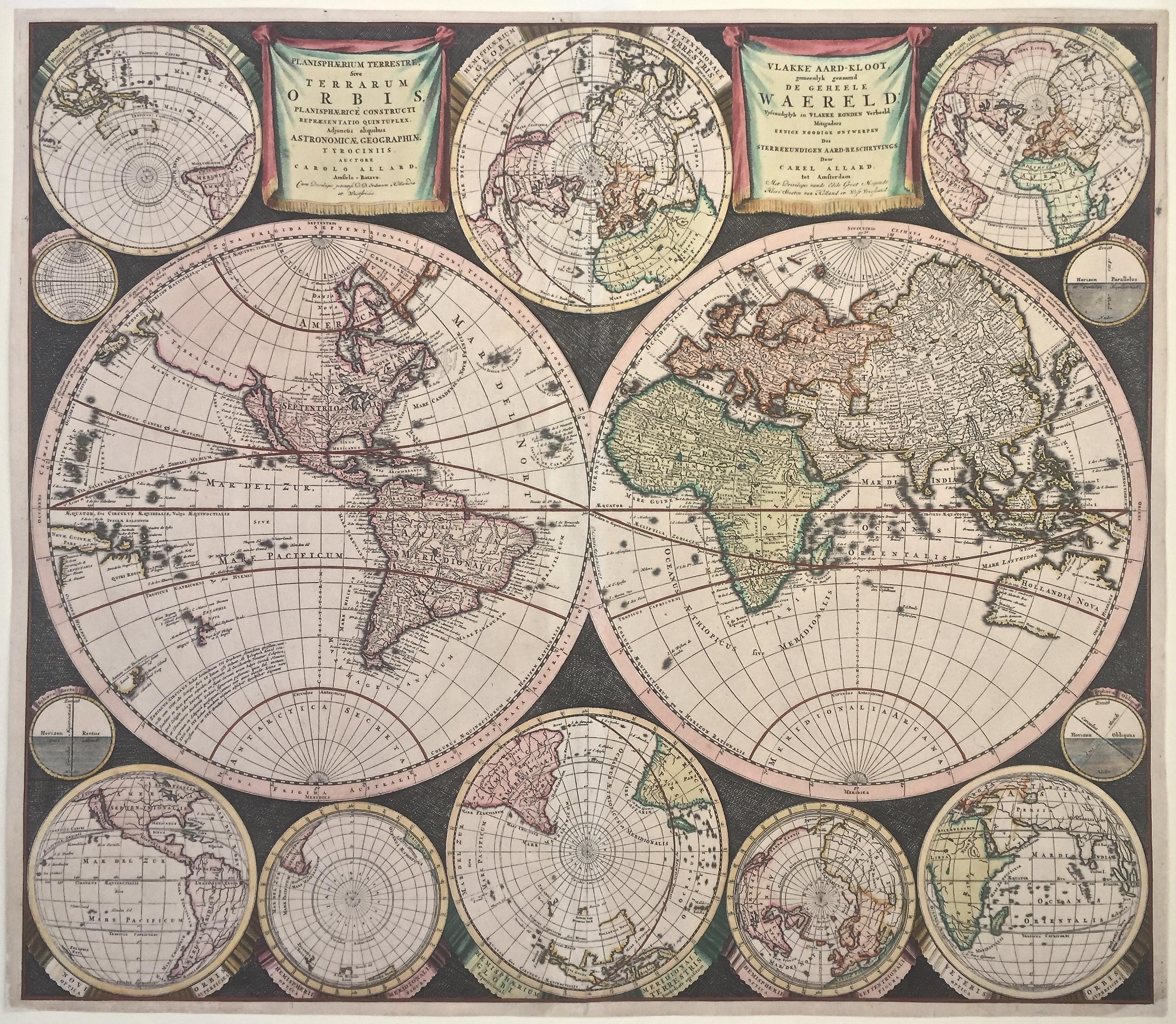
WORLD MAP - Planisphaerium Terrestre Sive Terrarum Orbis... 1696
By Carel Allard
Located in Santa Monica, CA
CAREL ALLARD (1648 – 1709)
PLANISPHAERIUM TERRESTRE SIVE TERRARUM ORBIS… 1696 (Shirley 578)
Engraving, 20 ½ x 23 ½”, sheet 21 x 24 1/8". A stunning double hemisphere World Map...
Category
17th Century Old Masters Landscape Prints
Materials
Engraving

Antique Map of the Eastern Part of the World
Located in Langweer, NL
Antique map titled 'Nieuwe Kaart van het Oostelykste Deel der Weereld, diendende tot aanwyzing van de Scheepstogten der Nederlanderen Naar Oostindie'. This finely engraved map of the...
Category
Antique Mid-18th Century Maps
Materials
Paper
Interesting Original Antique Hemisphere Map Showing the Latest Discoveries
Located in Langweer, NL
Antique world map titled 'A Map of the World from the best Authorities'. Detailed map of the World, showing tracks of Captain James Cook in his 3 voyages in great detail. The map is ...
Category
Antique Late 18th Century Maps
Materials
Paper

$1,052 Sale Price
20% Off
Very Decorative Original Antique Map of the World, Published in France in c.1780
By Rigobert Bonne
Located in Langweer, NL
Antique map titled 'L'Ancien Monde Et Le Nouveau en Deux Hemispheres' - Double hemisphere map of the World, showing the contemporary geographical...
Category
Antique 18th Century Maps
Materials
Paper

$736 Sale Price
20% Off