Items Similar to Hell Gate / Oyster Bay and Huntington / Huntington Bay

Want more images or videos?
Request additional images or videos from the seller
1 of 10
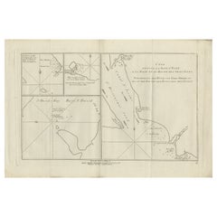
J. F. W. Des BarresHell Gate / Oyster Bay and Huntington / Huntington Bay1787.
1787.
$11,500
£8,761.09
€9,998.48
CA$16,160.22
A$17,611.80
CHF 9,326.21
MX$211,536.24
NOK 118,071.83
SEK 108,555.44
DKK 74,677.53
About the Item
HELL GATE / OYSTER BAY AND HUNTINGTON / HUNTINGTON BAY. This aquatint and line engraved map was published according to Act of Parliament Novr. 19th, 1778.
This chart is from the "Atlantic Neptune" by Captain Joseph Frederick Wallet DesBarres (1721-1824). It is one of the finest large-scale sea atlases of the United States and Canadian Atlantic coastline ever produced. The maps in the atlas were printed over a six-year period (1775-81) and are well known for their accurate portrayal of various sounds, bays, bars, and harbors, as well as navigational hazards. Maps from this atlas were used extensively by the Royal Navy during the American Revolution. This scarce chart shows the treacherous waters of Hell Gate and the North Shore of Long Island from Cold Spring Harbor to Eaton’s Neck. Framed in 1 3/4" receding wood molding with gold lip and finished with ultraviolet plexiglass.
- Creator:J. F. W. Des Barres (1722 - 1824)
- Creation Year:1787.
- Dimensions:Height: 31 in (78.74 cm)Width: 20.88 in (53.04 cm)
- Medium:
- Movement & Style:
- Period:
- Condition:
- Gallery Location:New York, NY
- Reference Number:1stDibs: LU33123956502
About the Seller
4.7
Recognized Seller
These prestigious sellers are industry leaders and represent the highest echelon for item quality and design.
Established in 1898
1stDibs seller since 2015
59 sales on 1stDibs
Associations
International Fine Print Dealers Association
- ShippingRetrieving quote...Shipping from: New York, NY
- Return Policy
More From This Seller
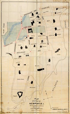
View AllPlan of a Part of Newport, R. I. Showing Changes... O. H. P, Belmont, Esq.
Located in New York, NY
PLAN OF A PART OF NEWPORT, R.I. SHOWING CHANGES IN HIGHWAYS ASKED FOR BY O.H.P. BELMONT, ESQ.
The original ink and watercolor plan on paper from 1907. The plan is extremely large; if fully assembled it would measure no less than 11.5 feet in height and 6.5 feet in breadth. Segmented and backed on modern linen in four sections – each section is 70 x 39 inches. This grand oversized folding map can be folded down to four sections each 17.5 x 11 inches and stored in a modern made leather and marble paper case 18 x 11.75 x 3 inches.
Text continues, "Prepared for Charles Warren Lippitt at the office of J. P. Cotton, C.E. Newport, R.I. Oct. 28, 1907." A fine manuscript plan of the Bellevue neighborhood of Newport, depicting the street layout and the detailed footprints of the area’s many mansions.
The plan was produced at the behest of Charles Warren Lippett (1846-1924), who served as governor of Rhode Island from 1895-1897. The Lippett “Breakwater” mansion is also shown on this plan, situated at the southernmost tip of the peninsula. Though the circumstances are unclear, Lippitt seems to have requested the plan be drawn out of some concern for road construction proposed by Oliver Hazard Perry...
Category
Early 20th Century Naturalistic More Art
Materials
Ink, Watercolor
Indiarum Occidentalium Tractus Littorales cum Insulis Caribicis / Pascaert van W
By Louis Renard
Located in New York, NY
This early 18th-century engraved map was published by Louis Renard in Amsterdam. The image size is 19 x 22 " (48.3 x 55.9 cm) plus margins.
A beautifully engraved Dutch sea chart. Shown is the entire Caribbean basin including the eastern seaboard up to Cape Cod and includes Bermuda. Florida is shown with the classic flattened southeastern coast that was derived by Hessel Gerritz. Noted are the routes taken by the Spanish treasure...
Category
18th Century Other Art Style More Prints
Materials
Engraving

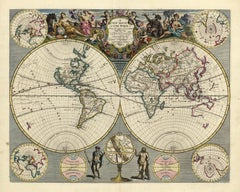
A NEW MAP OF THE WORLD from the Latest Observations.
By John Senex
Located in New York, NY
The title continues “…. Most Humbly Inscribd [sic] to his Royal Highness George Prince of Wales.”
A fine British produced double hemisphere world map. On this map, California is shown as an island on the main double hemisphere map...
Category
18th Century Other Art Style More Prints
Materials
Watercolor, Engraving
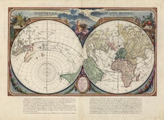
Nouvelle Mappe Monde, dediee au progres de nos connoissances.
Located in New York, NY
A handsome and well-engraved world map constructed with the prime meridian through Paris. The hemispheres are rotated through 45 degrees. This is an unusual projection for a world map and was based on the work of the French Academie Royale des Sciences. This particular impression is by Remondini who re-issued Santini's "Atlas Univ." in 1784. "Nouvelle Mappe Monde" is a copper plate engraving published by Giuseppe Remondini, Venice. The printed image size is just over 15 x 25 inches. Overall the map is in good condition with three small tears at the paper edge - all repaired. Modern (not 18th...
Category
18th Century Other Art Style More Prints
Materials
Watercolor, Engraving
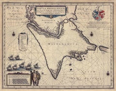
Tabula Magellanica, qua Tierra del fuego, cum celeberrimis fretis a F. Magellano
By Joan (Johannes) Blaeu
Located in New York, NY
This mid 17th-century map was published by Guiljelmum Blaeu in Amsterdam. The engraved map is 16 1/8 x 21" (41 x 53.1 cm) with beautiful original hand color. Tabula Magellanica is a highly decorative map of the southern tip of South America, including Tierra del Fuego...
Category
Mid-17th Century Other Art Style More Prints
Materials
Engraving
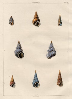
Scalaria. Univalves.
By George Perry
Located in New York, NY
This early 19th-century aquatint was engraved and colored by Mr. John Clarke after drawings by George Perry. The publication, CONCHOLOGY, OR, THE NATURAL HISTORY OF SHELLS… , was pub...
Category
Early 19th Century Naturalistic More Prints
Materials
Aquatint
You May Also Like
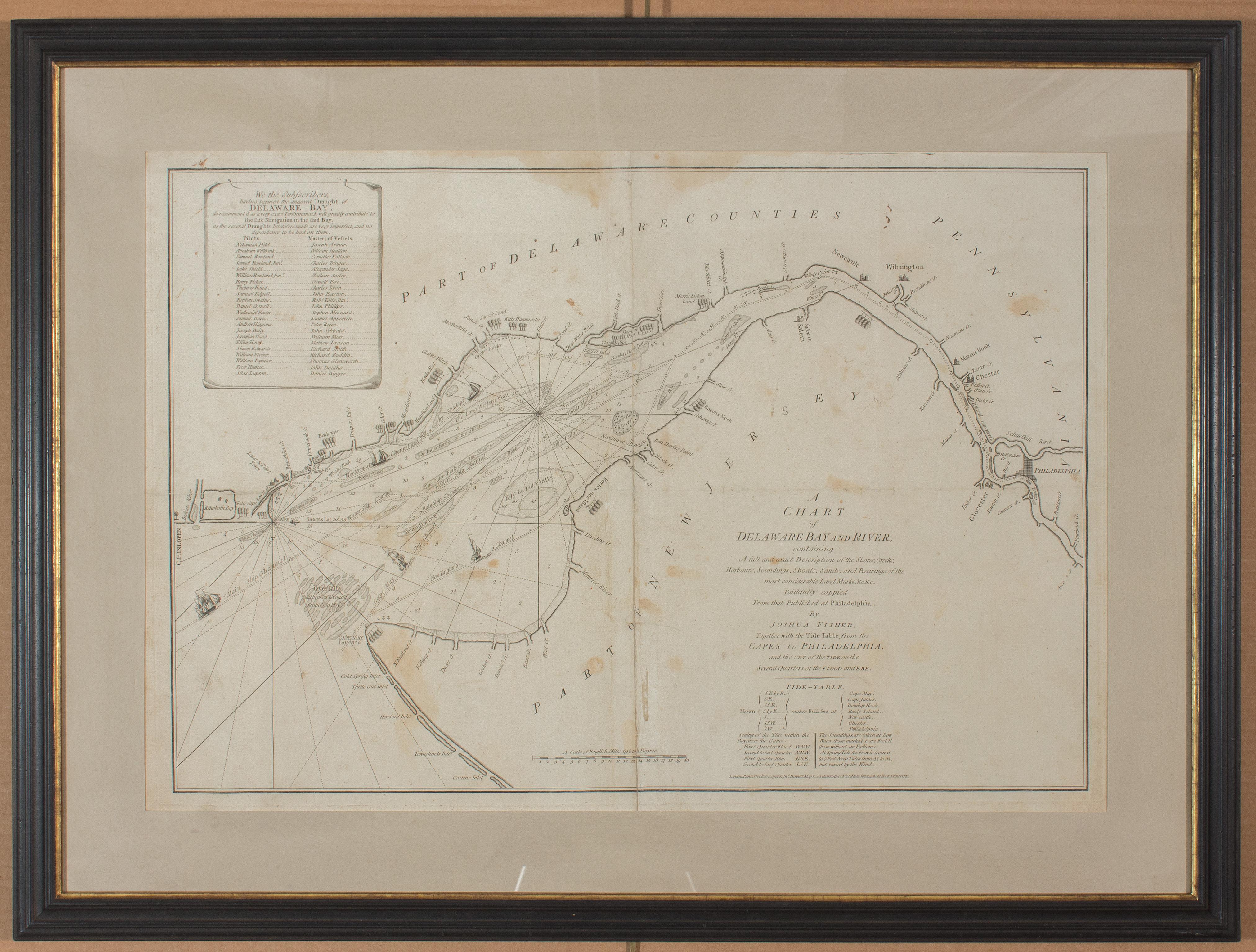
1776 Navigational chart/map of the Delaware bay and river including Philadelphia
Located in Philadelphia, PA
JOSHUA FISHER
(AMERICAN, EIGHTEENTH CENTURY)
A Chart of Delaware Bay and River, 1776
Printed for John Bennet and Robert Sayer, London
Engraving on pape...
Category
1770s Realist Landscape Prints
Materials
Paper, Engraving

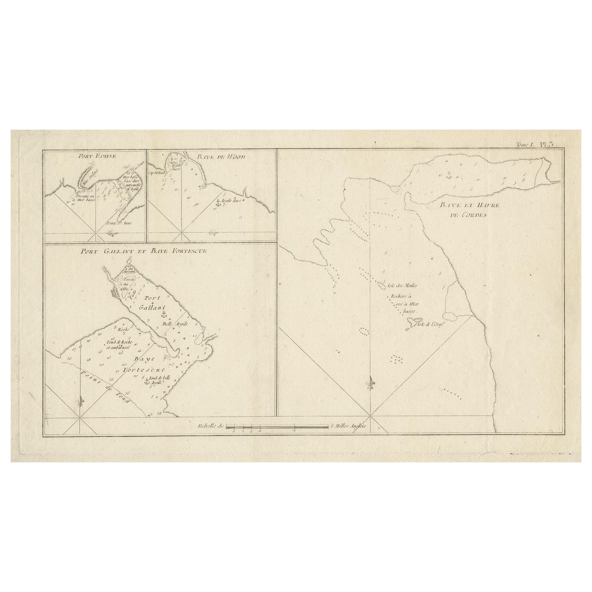
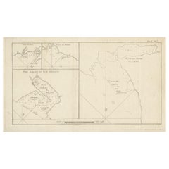
Antique Map of Cordes Bay and Surroundings
Located in Langweer, NL
Antique map titled 'Baye et Havre de Cordes (..)'. Four maps on the one sheet of; Cordes Bay, Port Famine, Woods Pay, Port Gallant, Fortescue Bay, Chile based on the voyage of John B...
Category
Antique Late 18th Century Maps
Materials
Paper
$248 Sale Price
20% Off
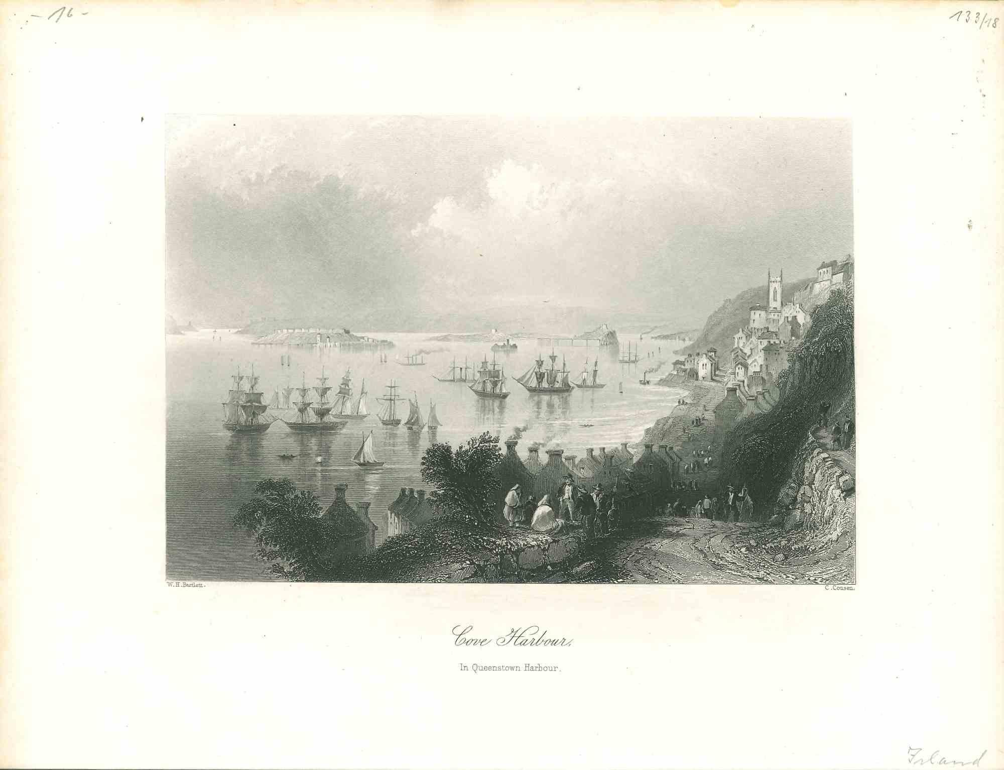
Cove Harbour - Original Lithograph - Mid-19th Century
Located in Roma, IT
Cove Harbour is an original modern artwork realized in Germany in the Mid-19th Century.
Original B/W Lithograph on Ivory Paper.
Inscripted on the lower central margin: Cove Harbou...
Category
Mid-19th Century Modern Figurative Prints
Materials
Lithograph
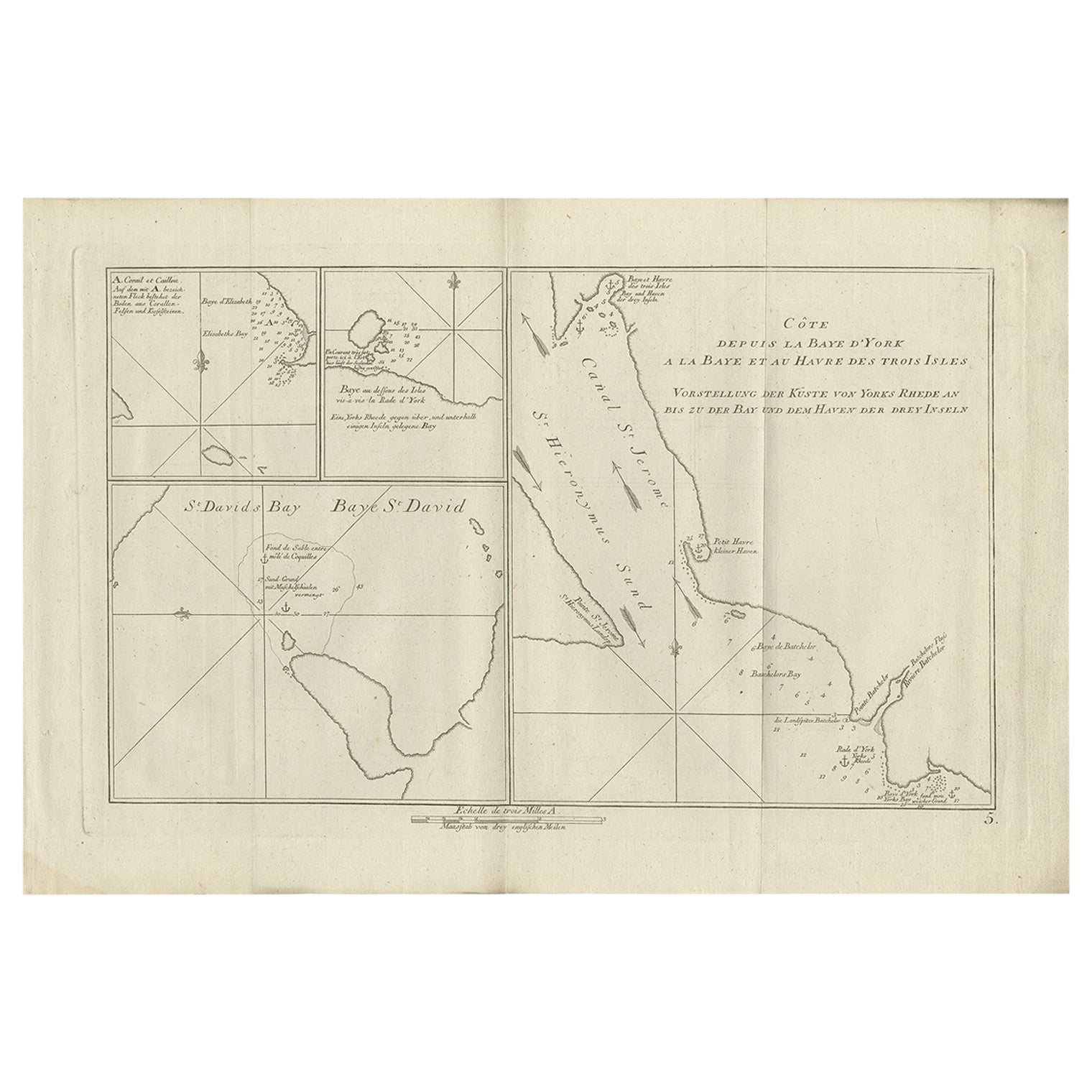
Antique Chart of York's Bay and Surroundings by Hawkesworth, 1774
Located in Langweer, NL
Antique print titled 'Baye St. David (..)'. Charts of York's Bay, Haven of the Three Islands, St. David's Bay, and Elizabeth's Bay. Originates from 'Geschichte der See-Reisen und Ent...
Category
Antique 18th Century Prints
Materials
Paper
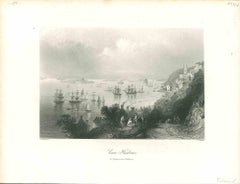
New York in 1835 from the Bay near Bellows Island
By Raoul Varin
Located in Paonia, CO
New York in 1835 from the bay near Bellows Island
Raoul Varin ( 1856 - 1943 )
Hand-colored aquatint 1931
paper size 24.50 x 35
image size 17 x 22.75
cond...
Category
Early 20th Century Landscape Prints
Materials
Aquatint
$720 Sale Price
20% Off
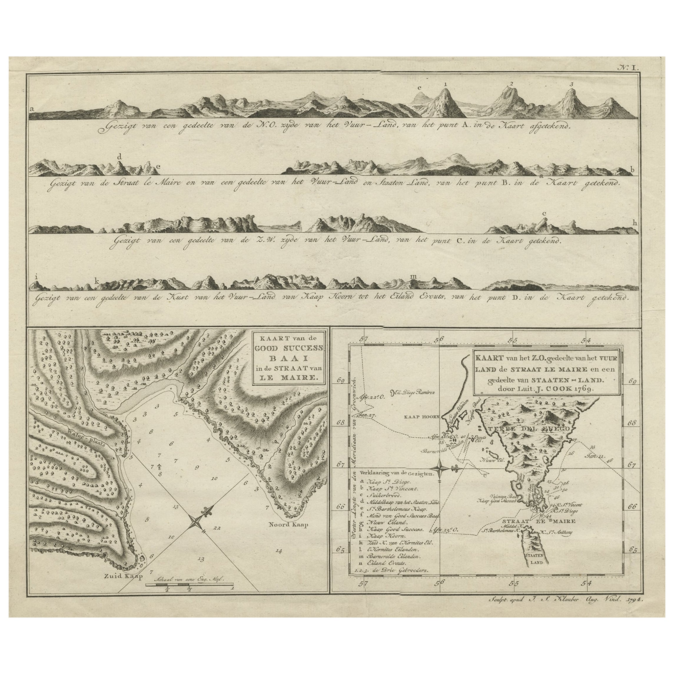
Antique Map of the Strait of Le Maire Between Terra Fuego & Staten Island, 1803
Located in Langweer, NL
Antique map titled 'Kaart van de Good Success Baai in de Straat van Le Maire (..)'.
Antique map of the Strait of Le Maire between Terra Fuego and Staten Island. On top, various c...
Category
Antique Early 1800s Maps
Materials
Paper
$603 Sale Price
20% Off
More Ways To Browse
Royal Navy Antique
Oyster Art
American Revolution
Eaton Antique
Antique Wallets
A J Bayer
Vintage Showgirls Art
Vintage Sugar Poster
Vintage Us Army Posters
Wiesbaden Poster
Yoko Ono Imagine Peace
York Railway Poster
Yoshitomo Nara Real One
1965 Salvador Dali Prints
Aboriginal Art Print
Alaska Poster
Albertus Seba Coral Print
Aldo Mazza