Items Similar to 1950 illustrated map Italy, Land of Saints and Sanctuaries

Want more images or videos?
Request additional images or videos from the seller
1 of 8
Unknown1950 illustrated map Italy, Land of Saints and Sanctuaries1950
1950
$1,130.11
£837.21
€950
CA$1,554.40
A$1,728.93
CHF 907
MX$21,096.93
NOK 11,383.95
SEK 10,728
DKK 7,233.17
About the Item
In 1950, a highly detailed and artistically illustrated map titled Italie Terre de Saints et de Sanctuaires (Italy, Land of Saints and Sanctuaries) was published in Témoignage Chrétien, a major French Catholic weekly magazine. This beautiful and intricate work of art reflects both the religious significance of Italy in the Christian tradition and the flourishing tradition of sacred cartography, which sought to visually represent religious landscapes and the geography of faith.
The map was created for the Année Sainte 1950 (Holy Year 1950), a jubilee year in the Catholic Church, called by Pope Pius XII. Holy Years, or jubilees, are times of special indulgence, pilgrimage, and spiritual renewal, making this document both a visual guide for pilgrims and a celebratory work of art marking the sanctity of Italy’s religious sites. The subtitle, Terre de Saints et de Sanctuaires, emphasizes Italy’s importance as a cradle of Christian saints and the home to countless holy shrines.
The illustration is a finely crafted visual overview of Italy, featuring important religious landmarks from different regions, with saints and holy figures depicted alongside the places of their historical or spiritual significance. Churches, monasteries, and cathedrals populate the map, illustrating Italy’s deep religious heritage. Rome, the heart of Catholicism, is prominently featured in the center of the map with grand depictions of Saint Peter’s Basilica and the Vatican.
At the top right corner, a large decorative cartouche frames the title, Italie Terre de Saints et de Sanctuaires. Two saints, possibly Saint Francis of Assisi and Saint Anthony of Padua, two of Italy’s most revered religious figures, stand below the banner “Pax et Bonum” (Peace and Good), a phrase associated with Saint Francis’s teachings. The cartouche is crowned with religious symbols, underlining the spiritual purpose of the map.
The surrounding seas, including the Mediterranean, Ligurian, Tyrrhenian, Ionian, and Adriatic, feature additional artistic elements such as a medieval-looking ship manned by a holy figure, symbolizing religious journeys, perhaps hinting at Saint Peter’s journey to Rome. The compass rose at the bottom left corner adds a navigational element, guiding the viewer through the sacred geography of Italy.
Italy itself is richly populated with miniature illustrations of its religious heritage. From the northern reaches near Venice and Milan down to the southernmost regions of Sicily and Sardinia, each part of the peninsula is marked by tiny drawings of religious sites, figures, and local saints. These illustrations not only point to famous pilgrimage destinations but also to lesser-known holy places, emphasizing the widespread and deep-rooted Catholic faith across the entire country.
The religious significance of each site is conveyed through symbols, including churches, crosses, and altars, with some of the figures depicted participating in religious rituals or moments from the lives of saints. Notable holy cities like Assisi, home of Saint Francis, and Padua, known for Saint Anthony, are illustrated with extra attention, alongside other notable sanctuaries like the one in Loreto, a key Marian pilgrimage site. The detail and care given to each illustration suggest that this map was designed not only as a visual aid but as a tool of devotion, intended to inspire faith and reflection in those who viewed it.
This map serves as a cultural and religious artifact, encapsulating the importance of pilgrimage during the Holy Year and celebrating Italy’s rich Christian history. By combining cartography with religious iconography, the map creates a bridge between the physical act of pilgrimage and the spiritual journey undertaken by the faithful. In its attention to detail and reverence for sacred places, it reflects the enduring influence of religious traditions on artistic expression.
In summary, the Italie Terre de Saints et de Sanctuaires map from 1950 is a testament to Italy’s unique role as a hub of Christian pilgrimage and spiritual history. Published during a Holy Year, it emphasizes both the visual beauty of religious landmarks and their deep significance to the Catholic faith. Today, it stands as a historical document of devotion and an artwork that continues to inspire appreciation for Italy’s vast spiritual landscape.
Illustrated document
Religion - Italy - Map
Holy Year 1950
G. de Agostini Milan
- Creation Year:1950
- Dimensions:Height: 31.11 in (79 cm)Width: 22.45 in (57 cm)
- Medium:
- Period:
- Condition:Good condition, traces of folds, tears, on linen.
- Gallery Location:PARIS, FR
- Reference Number:1stDibs: LU1792215284952
About the Seller
5.0
Platinum Seller
Premium sellers with a 4.7+ rating and 24-hour response times
Established in 2021
1stDibs seller since 2022
171 sales on 1stDibs
Typical response time: 1 hour
- ShippingRetrieving quote...Shipping from: PARIS, France
- Return Policy
Authenticity Guarantee
In the unlikely event there’s an issue with an item’s authenticity, contact us within 1 year for a full refund. DetailsMoney-Back Guarantee
If your item is not as described, is damaged in transit, or does not arrive, contact us within 7 days for a full refund. Details24-Hour Cancellation
You have a 24-hour grace period in which to reconsider your purchase, with no questions asked.Vetted Professional Sellers
Our world-class sellers must adhere to strict standards for service and quality, maintaining the integrity of our listings.Price-Match Guarantee
If you find that a seller listed the same item for a lower price elsewhere, we’ll match it.Trusted Global Delivery
Our best-in-class carrier network provides specialized shipping options worldwide, including custom delivery.More From This Seller
View AllIllustrated map of Italy by Umberto Zimelli dating from 1933
Located in PARIS, FR
Very nice illustrated map of Italy dating from 1933.
Italy - Tourism
Category
1930s Prints and Multiples
Materials
Paper, Lithograph, Linen
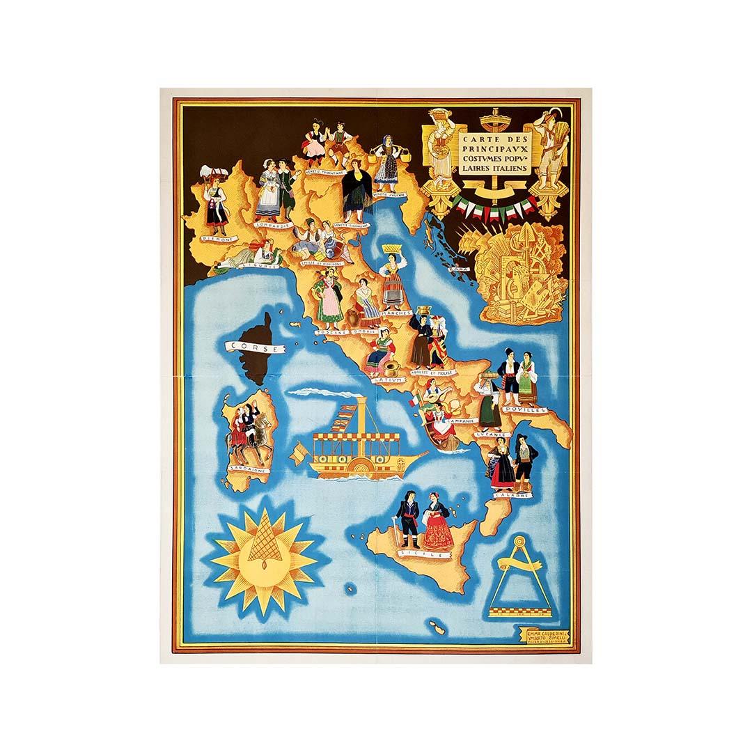
Illustrated map from 1934 of the main Italian popular costumes - Old map
Located in PARIS, FR
Very beautiful illustrated map from 1934 of the main Italian popular costumes.
Italy - Tourism
Category
1930s Prints and Multiples
Materials
Paper, Linen, Lithograph

1947 original map Gouvernement Généraux du Poitou, du Pays d'Aunis
Located in PARIS, FR
The 1947 original map Gouvernement Généraux du Poitou, du Pays d'Aunis et de Saintonge Angoumois, created by Louis Larmat and printed by Dorel in Paris, is a beautifully detailed cartographic representation of a historically significant region in western France. This map, part of Larmat’s extensive body of work, is known for its artistic craftsmanship and geographical precision, offering a comprehensive view of the historical administrative regions of Poitou, Aunis, Saintonge, and Angoumois, which played key roles in the political and cultural history of France.
Louis Larmat is celebrated for his contributions to cartography, particularly for his ability to merge historical context, topographical detail, and aesthetic elegance in his maps. His works, especially those focusing on the vinicultural regions of France, are highly respected for their accuracy and artistry. This particular map, although focusing on a more political and historical aspect rather than the wine regions he is most famous for, continues his tradition of detailed regional documentation. Larmat’s cartographic works often transcended the realm of simple geographical depiction, becoming historical documents that encapsulate the cultural essence of the regions they portray.
This map illustrates the general governments (administrative divisions) of the provinces of Poitou, Aunis, Saintonge, and Angoumois, regions that are steeped in history. These areas, situated along France’s western coastline, have been integral to the country’s political, economic, and cultural development over centuries. The region of Poitou, for example, is historically known as the birthplace of Eleanor of Aquitaine...
Category
1940s Prints and Multiples
Materials
Lithograph, Paper

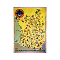
Circa 1935 map illustrated by André Giroux of the P.O Midi railroad network.
Located in PARIS, FR
Very beautiful map illustrated by André Giroux of the P.O Midi railroad network.
The railway company from Paris to Orleans and the Midi (PO Midi) is the n...
Category
1930s Prints and Multiples
Materials
Paper, Lithograph, Linen
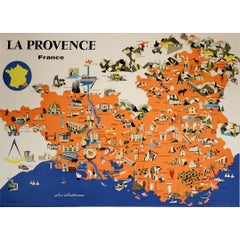
1958 map poster dedicated to La Provence France’s most cherished regions
Located in PARIS, FR
This vibrant 1958 map poster dedicated to La Provence offers a whimsical and informative journey through one of France’s most cherished regions. Combining charm and clarity, it serve...
Category
1950s Prints and Multiples
Materials
Linen, Paper, Lithograph
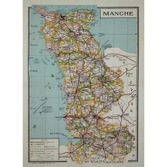
Circa 1950 original illustrated map by André Lesot for "Carte de la Manche"
Located in PARIS, FR
The circa 1950 original illustrated map by André Lesot for "Carte de la Manche" is a significant piece that highlights both artistic design and geographic representation. Created dur...
Category
1950s Prints and Multiples
Materials
Lithograph, Linen, Paper
You May Also Like
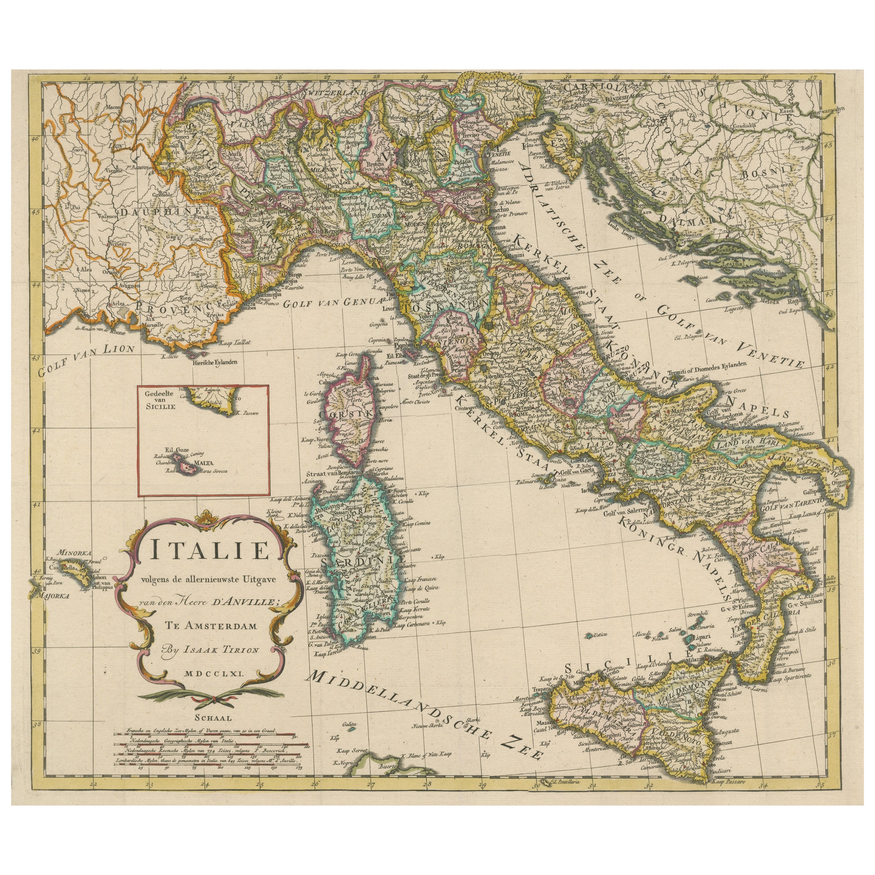
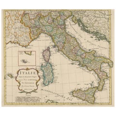
Detailed Antique Map of Italy and surrounding Islands
Located in Langweer, NL
Antique map titled 'Italie volgens de allernieuwste Uitgave van den Heere d'Anville'. Very detailed antique map, based on D'Anville's important map of It...
Category
Antique Mid-18th Century Maps
Materials
Paper
$590 Sale Price
20% Off
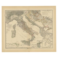
Antique Map of Italy and Other Regions Near the Adriatic Sea
Located in Langweer, NL
Antique map titled 'Italie et Provinces Autrichnes sur l'Adriatique'. Original old map of Italy and surroundings. Also shows Sicily and Sardinia. Ori...
Category
Antique Mid-19th Century Maps
Materials
Paper
$161 Sale Price
20% Off
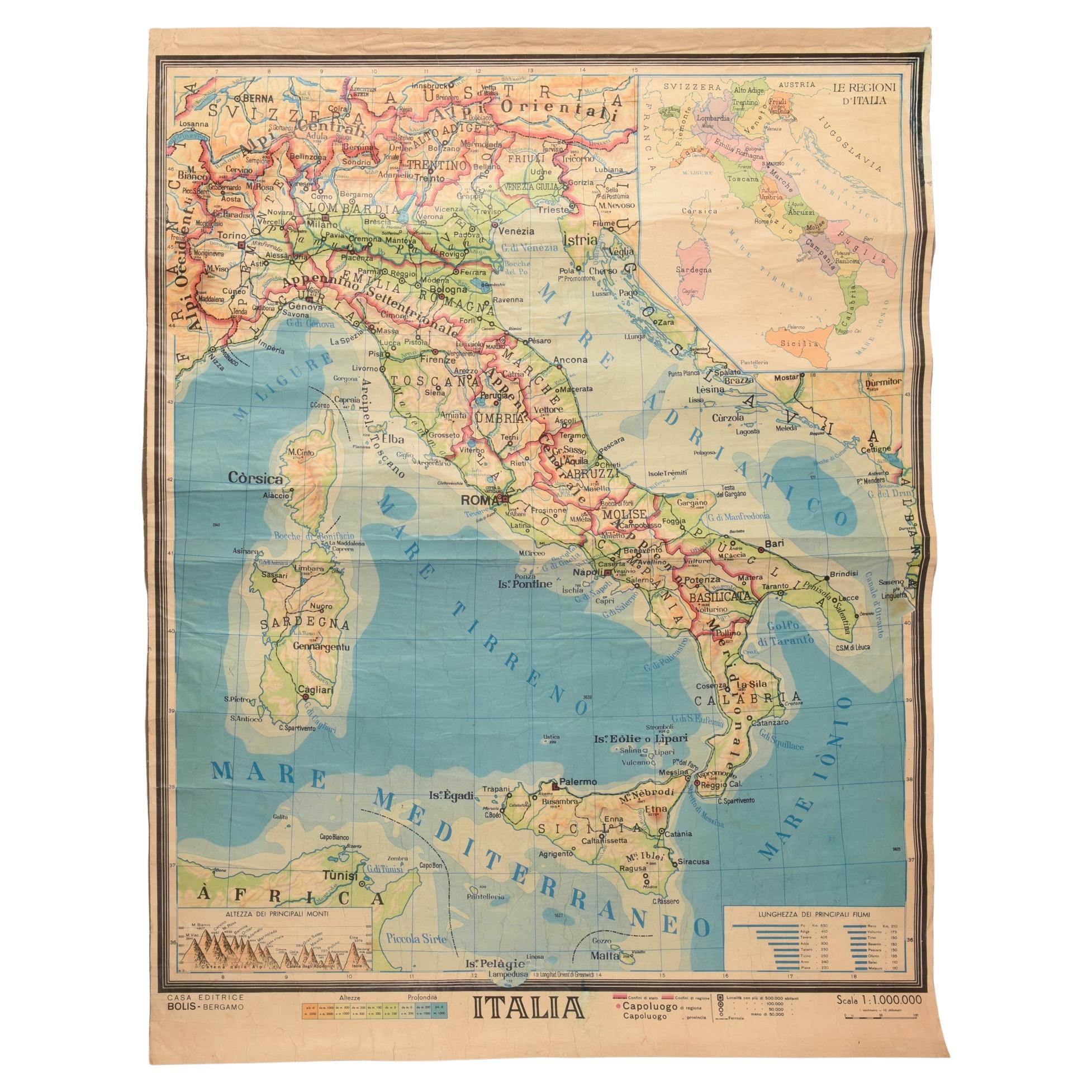
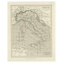
Geographical Map of Italy
Located in Alessandria, Piemonte
BOLIS Publishing House - Bergamo.
A beautiful large map of Italy, on paper but suitably reinforced to preserve it correctly. The maps were usually p...
Category
Mid-20th Century Italian Other Prints
Materials
Paper

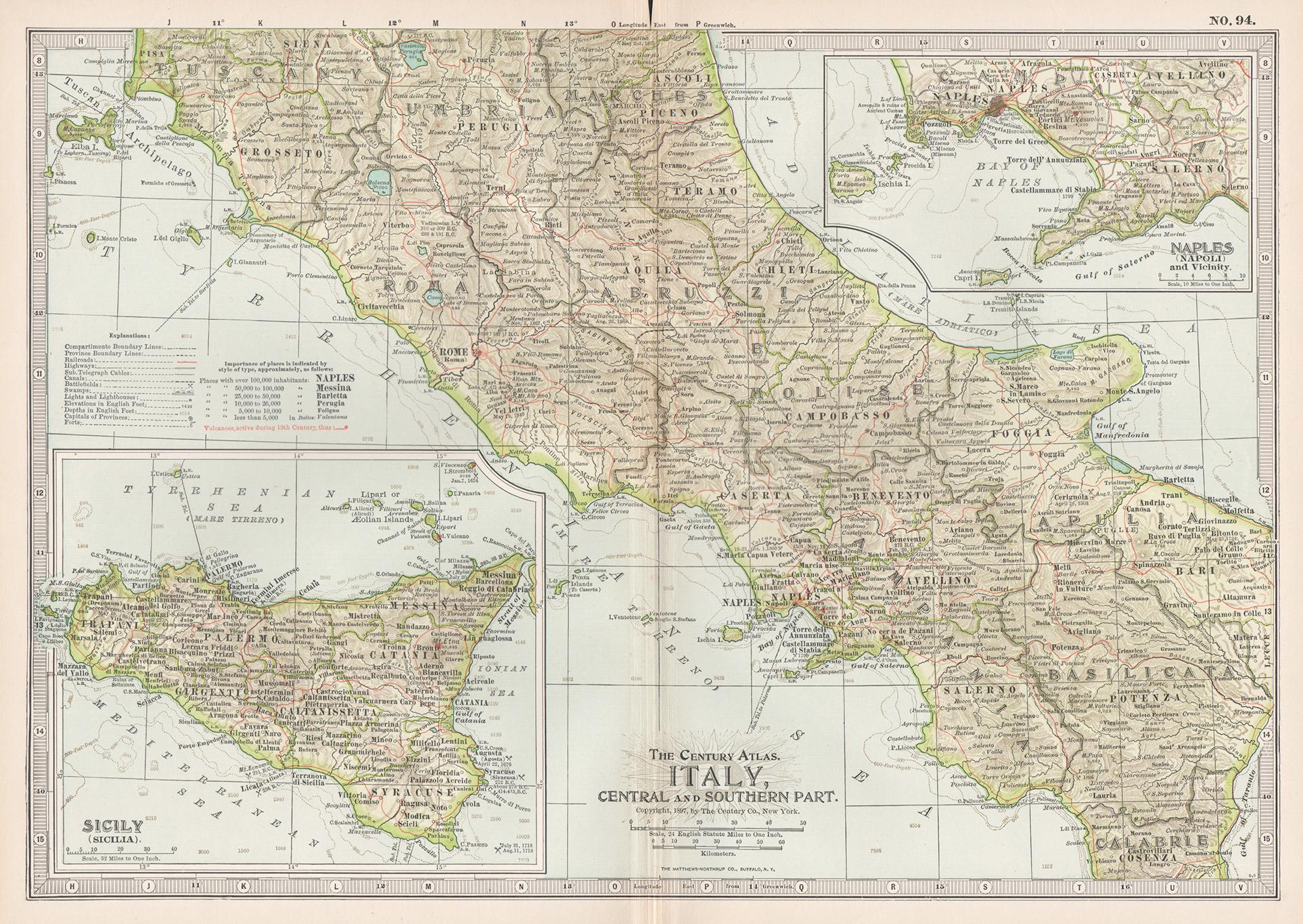
Italy, Central and Southern Part. Century Atlas antique map
Located in Melbourne, Victoria
'The Century Atlas. Italy, Central and Southern Part.'
Original antique map, 1903.
Inset maps of Sicily and Naples.
Central fold as issued. Map name an...
Category
Early 20th Century Victorian More Prints
Materials
Lithograph

Antique Map of The Regions of Italy and Sicily during the Roman Empire, 1880
Located in Langweer, NL
This map is an original antique engraving titled "ITALIAE REGIONES IIII SICILIA," which translates to "The Regions of Italy and Sicily." This detailed historical map portrays the reg...
Category
Antique 1880s Maps
Materials
Paper

$352 Sale Price
20% Off
Free Shipping
Roman Italy and Provinces: A Cartographic Snapshot, 1880
Located in Langweer, NL
The map titled "ITALIA, Gallia Cisalpina, Sicilia, Sardinia, Corsica" focuses on Italy and its surrounding regions during Roman times. It offers a detailed depiction of the Italian peninsula, the Po Valley (Gallia Cisalpina), and the islands of Sicily, Sardinia, and Corsica.
Produced as part of the "Spruner-Menke Atlas Antiquus" by Karl Spruner von Merz and edited by Theodorus Menke, this map reflects the 19th-century European scholarship on ancient geography and history.
The period represented is likely during the Roman Republic or early Roman Empire, suggested by the level of detail in regions like Latium and Campania, which were central to Roman culture and power. This era was marked by Roman expansion and consolidation of the Italian peninsula, as well as the Punic Wars, which led to Roman dominance over the Mediterranean.
What makes this map interesting is its:
1. **Rich Detail**: The map delineates the intricate network of Roman roads, cities, and colonies, showing the infrastructure that facilitated Roman administration and control.
2. **Strategic Locations**: It identifies strategic locations like harbors and passes, crucial for trade and military campaigns.
3. **Geographic Accuracy**: It reflects the geographical knowledge of the time, with an accurate representation of the topography that shaped the development of these regions.
4. **Cultural and Historical Sites**: Insets of important sites like Syracuse offer a closer look at places of historical significance.
5. **Educational Purpose**: The map was designed to aid in the study of Roman history, providing a visual tool for understanding the ancient world...
Category
Antique 1880s Maps
Materials
Paper