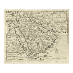
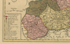
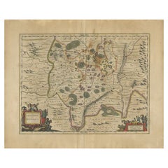
18th Century Map of Arabia – Tirion, Amsterdam c.1730
Located in Langweer, NL
Antique Map of Arabia – Isaak Tirion’s “Nieuwe Kaart van Arabia,” Amsterdam c.1730 This finely
Category
Mid-18th Century Dutch Antique Maps Amsterdam
Materials
Paper
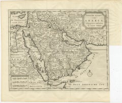
18th Century Map of Arabia – Tirion, Amsterdam c.1730
Located in Langweer, NL
Antique Map of Arabia – Isaak Tirion’s “Nieuwe Kaart van Arabia,” Amsterdam c.1730 This finely
Paper
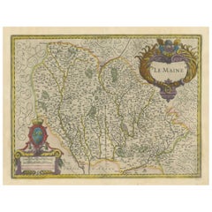
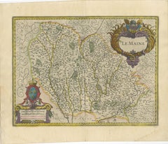
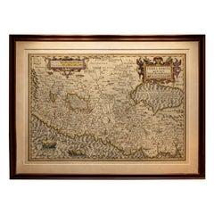
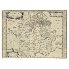
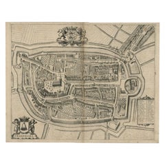
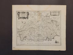
Map of Le Maine by H. Hondius, 1633, Hand-Colored, Decorative and Historic
Located in Langweer, NL
beautifully executed antique map titled 'Le Maine' was published in 1633 by Henricus Hondius in Amsterdam, and
Paper
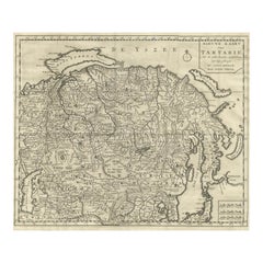
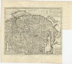
Antique Map of Tartary, Siberia & China – Tirion, Amsterdam c.1730
Located in Langweer, NL
Antique Map of Tartary – “Nieuwe Kaart van Tartarie” by Isaak Tirion, Amsterdam c.1730 This finely
Paper

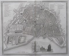
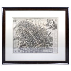
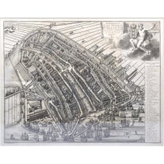
Original Antique Map or City Plan of Amsterdam, Netherlands. Circa 1835
Located in St Annes, Lancashire
Nice map of Amsterdam Drawn and engraved by J.Dower Published by Orr & Smith. C.1835 Unframed
Paper
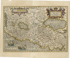
Holy Land Map – Terra Sancta Palestina, Hondius, Hand-Colored Engraving c.1620
Located in Langweer, NL
sacris Terra Promissionis olim Palestina. The map was produced by Jodocus Hondius in Amsterdam around
Paper

Rare Original Map of New Amsterdam (New York) – “Restitutio”, ca. 1674 –
Located in Dronten, NL
An exceptionally rare and original 17th-century engraving of New Amsterdam, now New York City
Paper
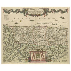
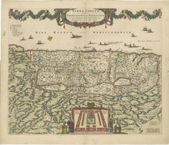
Frederic de Wit Map of Palestine – Terra Sancta, Amsterdam c.1670
Located in Langweer, NL
Terra Sancta sive Promissionis, olim Palestina – hand-coloured copper-engraved map of the Holy Land
Paper
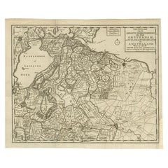
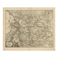
Antique Map of the Region of Amsterdam by Wagenaar, c.1760
Located in Langweer, NL
Antique map titled 'Nieuwe Kaart van de Ambagts - Heerlykheden der Stad Amsterdam, in Rynland
Paper

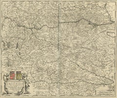
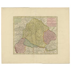
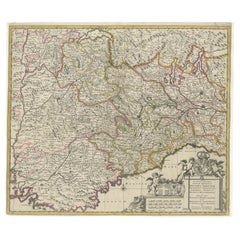
Decorative Antique Map of Austria – Frederick de Wit, Amsterdam c.1690
Located in Langweer, NL
Amsterdam cartographer whose maps were highly sought after for their clarity and beauty. His atlas
Paper
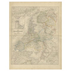
Map of the Netherlands with Insets of Amsterdam and Arnhem, Leiden 1876
Located in Langweer, NL
Map of the Netherlands with Insets of Amsterdam and Arnhem, Leiden 1876 This detailed 19th-century
Paper
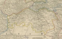
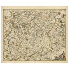
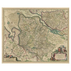
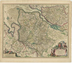
Antique Map of Hungary and Transylvania by Isaak Tirion, Amsterdam c.1740
Located in Langweer, NL
attractively hand-colored map of the Kingdom of Poland was published by Isaak Tirion in Amsterdam in the mid
Paper
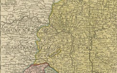
Hand-Colored Map of Westphalia – Copper Engraving by Ottens, Amsterdam c.1720
Located in Langweer, NL
Hand-Colored Map of Westphalia – Copper Engraving by Ottens, Amsterdam c.1720 This striking early
Paper
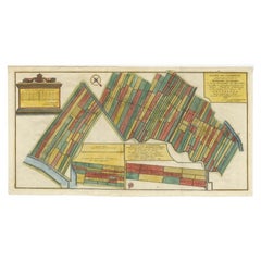

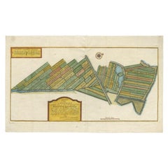
Antique Map Showing Estates of 1669 in Amsterdam, Published in c.1767
Located in Langweer, NL
Antique map titled 'Kaart der landeryen, gelegen aan of onder de honderd gaarden, zo in de
Paper

Antique Map Showing Estates of 1669 in Amsterdam, Published in c.1767
Located in Langweer, NL
Antique map titled 'Kaart der landeryen, gelegen aan of onder de honderd gaarden, zo in de
Paper

$887Sale Price|25% Off
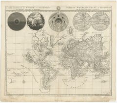
Antique World Map with Astronomical Spheres by Pierre Mortier, Amsterdam, c.1700
Located in Langweer, NL
Antique World Map with Astronomical Spheres by Pierre Mortier, Amsterdam, circa 1700 This
Paper
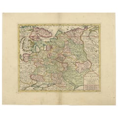
Original Antique Map of Muscovy or Russia by Isaak Tirion, Amsterdam circa 1740
Located in Langweer, NL
Map of Muscovy or Russia by Isaak Tirion, Amsterdam circa 1740 Description: This beautifully
Paper
Original Antique Map of Trier and Luxembourg by Joan Blaeu, Amsterdam circa 1640
Located in Langweer, NL
Map of Trier and Luxembourg by Joan Blaeu, Amsterdam circa 1640 This beautifully engraved and hand
Paper

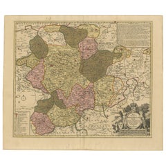
Antique Map of Piedmont, Savoy and Liguria by Justus Danckerts, Amsterdam c.1690
Located in Langweer, NL
Map of Piedmont, Savoy and Liguria by Justus Danckerts, Amsterdam c.1690 This richly detailed and
Paper

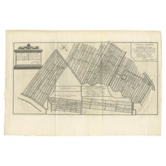
Antique Map of Estates of The Year 1669 in Amsterdam, Published c.1767
Located in Langweer, NL
(..)'. Map showing estates in Amsterdam in 1669. Published by Yntema and Tieboel, 1767. Artists and
Paper
Original Antique Map of the Duchy of Luxembourg by De Wit, Amsterdam circa 1680
Located in Langweer, NL
Map of the Duchy of Luxembourg by De Wit, Amsterdam circa 1680 Rare original antique map of the
Paper


1718 Ides & Witsen Map "Route D'amsterdam a Moscow Et De La Ispahan Et Gamron
Located in Norton, MA
1718 Ides & Witsen map, entitled "Route D'Amsterdam A Moscow Et De La Ispahan Et Gamron
Paper
Amsterdam city plan - Joost van Sassen
Located in UTRECHT, UT
of Dirck Jacobsz. In 1538 he painted the first complete and (relatively) accurate map of Amsterdam
Paper
$415Sale Price|20% Off
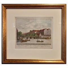
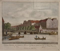
Framed View of the Brouwersgracht in Amsterdam, the Netherlands, 1708
Located in Langweer, NL
(..)'. Despite the title suggesting this print is a view of the West-Indisch House in Amsterdam, this is actually
Paper
$345Sale Price|20% Off
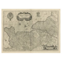
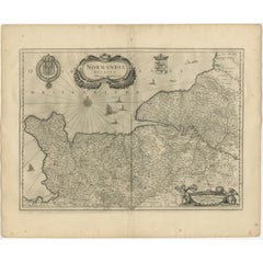
Antique Map of Normandy by Janssonius, 1657
Located in Langweer, NL
cartographer Jodocus Hondius he also set up a business as book publisher in Amsterdam. His first map was
Paper


$506Sale Price|20% Off
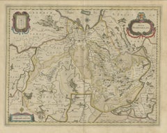
Antique Map of Switzerland by Janssonius, 1657
Located in Langweer, NL
business as book publisher in Amsterdam. His first map was published in 1616. Around 15 years later he set
Paper

$529Sale Price|20% Off
Antique Map of Overijssel by Visscher, c.1652
Located in Langweer, NL
Engravers: The Visscher family were art and map dealers in Amsterdam during the 17th century. Founded by C
Paper


$713Sale Price|20% Off
Antique Map of Overijssel by Visscher, c.1660
Located in Langweer, NL
Engravers: The Visscher family were art and map dealers in Amsterdam during the 17th century. Founded by C
Paper


1646 Jansson Map Entitled "Procinvia Connactiae, " Ric.a006
Located in Norton, MA
publisher in Amsterdam. His first map was published in 1616. Around 15 years later he set up a partnership
Paper
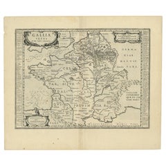

Antique Map of France by Janssonius, c.1650
Located in Langweer, NL
Hondius he also set up a business as book publisher in Amsterdam. His first map was published in 1616
Paper

Antique Map of France by Janssonius, c.1650
Located in Langweer, NL
Hondius he also set up a business as book publisher in Amsterdam. His first map was published in 1616
Paper

$637Sale Price|20% Off
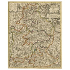
Antique Map of Bavaria with many details, Germany
Located in Langweer, NL
. Visscher. The Visscher family were art and map dealers in Amsterdam during the 17th century. Funded by C
Paper
$671Sale Price|20% Off
Antique Map of Upper Bavaria, Germany, circa 1690
Located in Langweer, NL
Nicolaus Visscher (1649-1702). The Visscher family were art and map dealers in Amsterdam during the 17th
Paper
$2,038Sale Price|25% Off
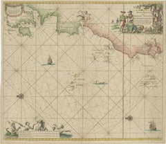
1717 Johannes Van Keulen Sea Chart of the Eastern Atlantic - Amsterdam to Gambia
Located in Langweer, NL
1717 Johannes Van Keulen Sea Chart of the Eastern Atlantic - Amsterdam to Gambia This 1717 sea
Paper
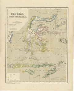
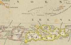
Antique Colonial Map of Celebes Sulawesi & Lesser Sunda Islands, 1884
Located in Langweer, NL
map was published in Amsterdam by Seyffardt’s Boekhandel and reflects the height of Dutch colonial
Paper

$454Sale Price|20% Off
Antique Map of Bavaria, Bayern, with original Hand Coloring
Located in Langweer, NL
shown. Published by N. Visscher, circa 1695. The Visscher family were art and map dealers in Amsterdam
Paper

$1,062Sale Price|20% Off
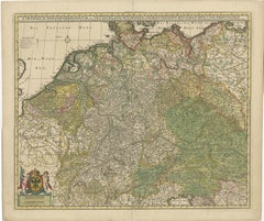
Antique Map of Germany and Central Europe, ca.1690
Located in Langweer, NL
. Published by N. Visscher, circa 1690. The Visscher family were art and map dealers in Amsterdam during the
Paper
$473Sale Price|20% Off
Antique Map of the Province of Overijssel, the Netherlands
Located in Langweer, NL
Hondius he also set up a business as book publisher in Amsterdam. His first map was published in 1616
Paper

$850Sale Price|20% Off
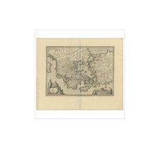
Antique Map of Greece by J. Jansson, circa 1653
Located in Langweer, NL
This is an authentic antique map of the Greece by Jan Jansson. The map was published in Amsterdam
Paper
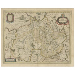
Decorative and Detailed Original Antique Map of Switzerland, 1657
Located in Langweer, NL
set up a business as book publisher in Amsterdam. His first map was published in 1616. Around 15 years
Paper


Antique Map of the Maine Region by Janssonius, 1657
By Johannes Janssonius
Located in Langweer, NL
business as book publisher in Amsterdam. His first map was published in 1616. Around 15 years later he set
Paper

$541Sale Price|20% Off
Decorative Antique Map of the Berry Region, France, 1657
Located in Langweer, NL
Hondius he also set up a business as book publisher in Amsterdam. His first map was published in 1616
Paper


$383Sale Price|20% Off
Antique Map of Nova Zembla by Janssonius, c.1650
Located in Langweer, NL
Hondius he also set up a business as book publisher in Amsterdam. His first map was published in 1616
Paper
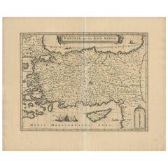
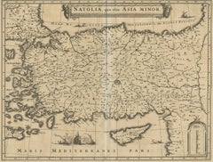
Antique Map of Asia Minor (Natolia) – Janssonius, circa 1650
Located in Langweer, NL
major Amsterdam-based map publisher and a contemporary of Blaeu, issued this map as part of his *Atlas
Paper
$241Sale Price|20% Off
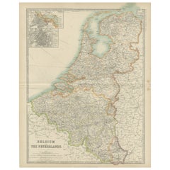
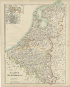
Antique Map of Belgium and the Netherlands by Johnston '1909'
Located in Langweer, NL
Netherlands. With inset maps of Amsterdam and Brussels. This map originates from the ‘Royal Atlas of Modern
Paper
$473Sale Price|20% Off
Antique Map of the region of Bremen and Verden, Germany
Located in Langweer, NL
Antique map titled 'Ducatus Bremae et Ferdae (..)'. Original antique map of the region of Bremen
Paper
$1,439Sale Price|20% Off
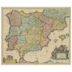
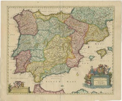
Antique Map of the Iberian Peninsula with two decorative Cartouches
Located in Langweer, NL
arms. Published by N. Visscher, circa 1680. The Visscher family were art and map dealers in Amsterdam
Paper
Antique Map of the City of Franeker by Janssonius, 1657
By Johannes Janssonius
Located in Langweer, NL
book publisher in Amsterdam. His first map was published in 1616. Around 15 years later he set up a
Paper

Antique Map of Drenthe, a Province in The Netherlands, 1658
Located in Langweer, NL
Antique map titled 'Drentia comitatus (..)'. Copper engraved contemp. hand coloured map of Drenthe
Paper
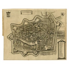

Antique Map of the City of Leeuwarden by Leti, 1690
Located in Langweer, NL
""Teatro Belgico"", Amsterdam: Willem de Jonge, 1690. These maps were originally used in a Janssonius atlas
Paper

1636 Jansson Map of Ireland Entitled "Comitatus Lageniae, " Ric.a007
Located in Norton, MA
publisher in Amsterdam. His first map was published in 1616. Around 15 years later he set up a partnership
Paper

1657 Janssonius Map of Vermandois and Cappelle, Ric. A-004
Located in Norton, MA
publisher in Amsterdam. His first map was published in 1616. Around 15 years later he set up a partnership
Paper

Antique Map of the Region of Lyon by Janssonius, 1657
By Johannes Janssonius
Located in Langweer, NL
business as book publisher in Amsterdam. His first map was published in 1616. Around 15 years later he set
Paper


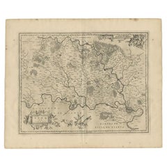
Antique Map of the Region of Nivernais by Janssonius, 1657
By Johannes Janssonius
Located in Langweer, NL
Hondius he also set up a business as book publisher in Amsterdam. His first map was published in 1616
Paper

Antique Map of the Region of Beauvais by Janssonius, 1657
Located in Langweer, NL
set up a business as book publisher in Amsterdam. His first map was published in 1616. Around 15 years
Paper
Antique Map of the Region of Bresse by Janssonius, 1657
Located in Langweer, NL
set up a business as book publisher in Amsterdam. His first map was published in 1616. Around 15 years
Paper
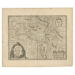

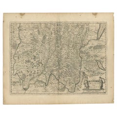
Antique Map of the Region of Rethel by Janssonius, 1657
By Johannes Janssonius
Located in Langweer, NL
business as book publisher in Amsterdam. His first map was published in 1616. Around 15 years later he set
Paper

Antique Map of the Region of Brie by Janssonius, 1657
Located in Langweer, NL
Hondius he also set up a business as book publisher in Amsterdam. His first map was published in 1616
Paper
Antique and vintage collectibles and curiosities can bring whimsy and wonder to any interior.
Decorating with old scientific instruments, historical memorabilia and vintage musical instruments, as well as other authentic collectibles and curiosities that can be found on 1stDibs, presents an opportunity to create a unique, natural history museum-like atmosphere in your home that can provoke conversation as often as it pays tribute to how far we’ve come in understanding our world.
And bringing collectibles and curiosities into your space is actually on trend — Wunderkammern, or curiosity cabinets, were all the rage in Europe during the 1500s and continued to have adherents there and in the U.S. in the following centuries. Today, however, they’re experiencing a real surge in popularity and influencing how many interior designers are furnishing and decorating homes — combining contemporary with antique, scientific with tribal, earthly with extraterrestrial, Les Lalanne tables with Flemish tapestries.
The original Wunderkammern were entire rooms filled with objects demonstrating their owners’ worldly knowledge: A proper one included artificiala or preciosa (objets d’art); naturalia (such as skeletons, shells, minerals); exotica (taxidermy or dried plants); and scientifica (scientific instruments), frequently alongside religious relics and ancient artifacts.
Pay tribute to a history of rich and diverse musical traditions that have taken shape all over the world by decorating your home with a collection of antique and vintage musical instruments — with a little help from strong hanging wire or some wall hooks, vintage brass instruments such as a gong, French horn or trumpet can help elevate a home office or complement the efforts you’ve made to ensure a welcoming vibe in your home’s entryway. Bells or antique wind instruments can add provocative metallic contrasts to dark woods as tabletop decorative objects.
Create an intriguing focal point with Georgian scientific instruments, such as stick barometers with mahogany cases or lacquered brass telescopes. These items stem from an era named for the monarchies of the four King Georges, who ruled England in succession starting in 1714 (plus King William’s reign, which lasted until 1837). Just as there was beautiful jewelry produced during the period that today is coveted by collectors, there is much to be found in the collectibles and curiosities realm too.
Wanderlust, nostalgia and a shared love of good design are contributing factors to certain trends in decorating — just as vintage trunks and luggage have reappeared as furniture or home accents in a bedroom or foyer, decorating with globes, maps or nautical objects is similarly rooted in the allure of travel and a penchant for the stylish finishing touch that collectibles bring to our homes.
Find a wide range of antique and vintage collectibles and curiosities on 1stDibs.
Produced in 1843, the well-preserved volume is evidence of the author's exacting specifications.
New or old, the coverlets add old-time charm to any space.
Get into the games! These items celebrate the events, athletes, host countries and sporting spirit.
French trendsetter and serial collector Daniel Rozensztroch tells us about his obsession with objects related to seafaring men.
It's hard to resist the allure of a beautiful pool. So, go ahead and daydream about whiling away your summer in paradise.
The sought-after designer worked with the team at Hoffman Creative to produce a monograph that beautifully showcases some of Studio Shamshiri's most inspiring projects.
Italian writer and collector Umberto Pasti opens the doors to his remarkable cave of wonders in North Africa.
Hollywood A-listers, ex-pat aristocrats and art collectors and style setters of all stripes appreciate the allure of the coastal California hamlet — much on our minds after recent winter floods.