Items Similar to Antique Map of Nova Zembla by Janssonius, c.1650


Want more images or videos?
Request additional images or videos from the seller
1 of 5
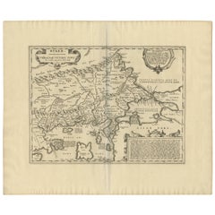
Antique Map of Nova Zembla by Janssonius, c.1650
About the Item
Antique map titled 'Nova Zemla, waygats fretum Nassovi cum et terra Samoiedum singula omnium emendatissime descripta'. This map depicts Nova Zembla and the northern continental coastline. Originates from 'Het Vijfde Deel Des Grooten Atlas, Vervatende De Water-Weereld (..)'. Artists and Engravers: Johannes Janssonius also known as Jan Jansson (1588-1664) was born in Arnhem, Netherlands. His father was a bookseller and publisher (Jan Janszoon the Elder). When he married the daughter of the cartographer Jodocus Hondius he also set up a business as book publisher in Amsterdam. His first map was published in 1616. Around 15 years later he set up a partnership with his brother in law Hondius add issued further editions of the Mercator/Hondius atlas. After his death his heirs still have published several maps. Many of his plates have been acquired by Pieter Schenk and Gerard Valk.
Artist: Johannes Janssonius also known as Jan Jansson (1588-1664) was born in Arnhem, Netherlands. His father was a bookseller and publisher (Jan Janszoon the Elder). When he married the daughter of the cartographer Jodocus Hondius he also set up a business as book publisher in Amsterdam. His first map was published in 1616. Around 15 years later he set up a partnership with his brother in law Hondius add issued further editions of the Mercator/Hondius atlas. After his death his heirs still have published several maps. Many of his plates have been acquired by Pieter Schenk and Gerard Valk.
Condition: Good. Margins extended, edges mounted to paper. Please study image carefully.
Date: c.1650
Overall size: 76.5 x 55 cm.
Image size: 0.001 x 51 x 41 cm.
Antique prints have long been appreciated for both their aesthetic and investment value. They were the product of engraved, etched or lithographed plates. These plates were handmade out of wood or metal, which required an incredible level of skill, patience and craftsmanship. Whether you have a house with Victorian furniture or more contemporary decor an old engraving can enhance your living space. We offer a wide range of authentic antique prints for any budget.
- Dimensions:Height: 21.66 in (55 cm)Width: 30.12 in (76.5 cm)Depth: 0 in (0.01 mm)
- Materials and Techniques:
- Period:
- Date of Manufacture:circa 1650
- Condition:
- Seller Location:Langweer, NL
- Reference Number:
About the Seller
5.0
Platinum Seller
These expertly vetted sellers are 1stDibs' most experienced sellers and are rated highest by our customers.
Established in 2009
1stDibs seller since 2017
1,933 sales on 1stDibs
Typical response time: <1 hour
- ShippingRetrieving quote...Ships From: Langweer, Netherlands
- Return PolicyA return for this item may be initiated within 14 days of delivery.
More From This SellerView All
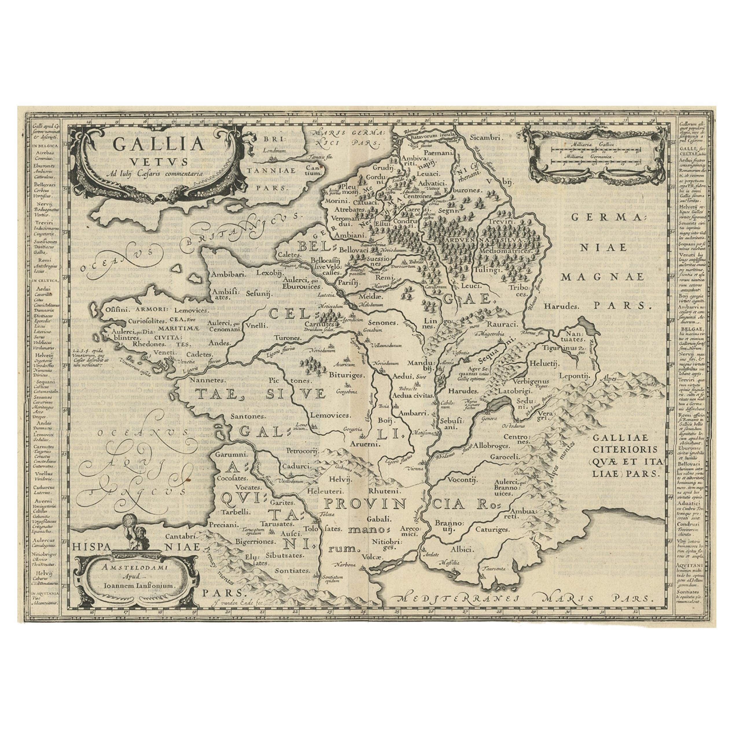
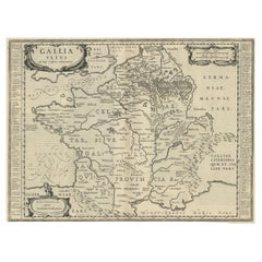
- Antique Map of France by Janssonius, c.1650Located in Langweer, NLAntique map titled 'Gallia Vetus'. Beautiful map of France based on Caesar's De Bello Gallico. In the columns to the left and right important tribes and people are described. Art...Category
Antique 17th Century Maps
MaterialsPaper
- Antique Map of France by Janssonius, c.1650Located in Langweer, NLAntique map titled 'Gallia Vetus'. Beautiful map of France based on Caesar's De Bello Gallico. In the columns to the left and right important tribes and people are described. Art...Category
Antique 17th Century Maps
MaterialsPaper
- Antique Map of Java by Janssonius, circa 1650Located in Langweer, NLAntique map titled 'Insulae Iavae cum parte insularum Borneo Sumatrae, et circumjacentium insularum novissima delineatio'. Beautiful map of Java and parts of Bali, Borneo, Sumatra an...Category
Antique Mid-17th Century Maps
MaterialsPaper
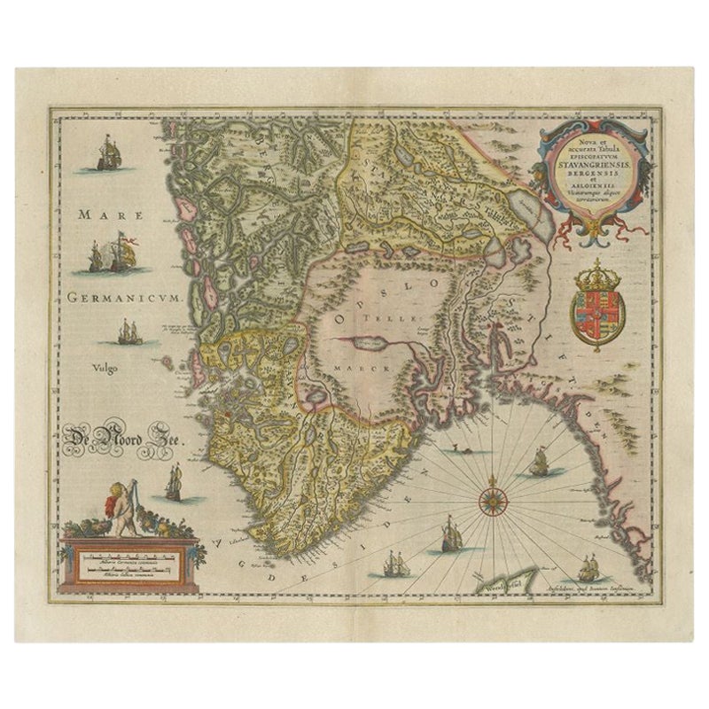
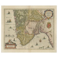
- Antique Map of Southern Norway by Janssonius, c.1650Located in Langweer, NL"Antique map titled 'Nova et Accurata Tabula Episcopatuum Stavangriensis et Asloiensis'. Old map of the southern part of Norway, it covers the region around Bergen. Decorated with ma...Category
Antique 17th Century Maps
MaterialsPaper
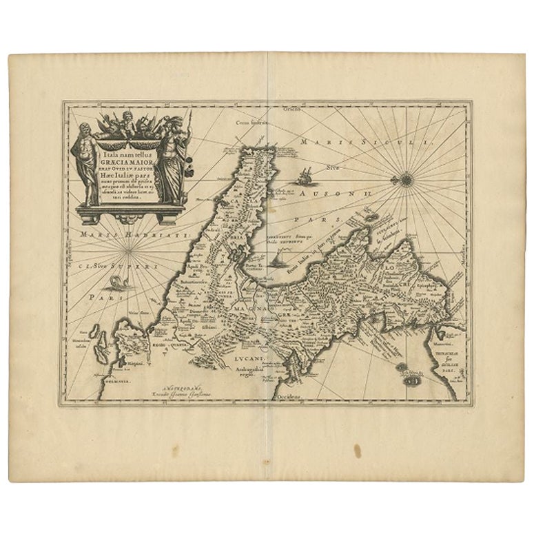
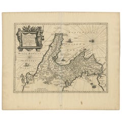
- Antique Map of Southern Italy by Janssonius, C.1650Located in Langweer, NL"Antique map titled 'Itala nam tellus Graecia Maior erat Ovid. IV. Fastor. Haec Italiae pars nunc primum de prica aerugine est abstersa (..)'. Beautiful map of Southern Italy...Category
Antique 17th Century Maps
MaterialsPaper
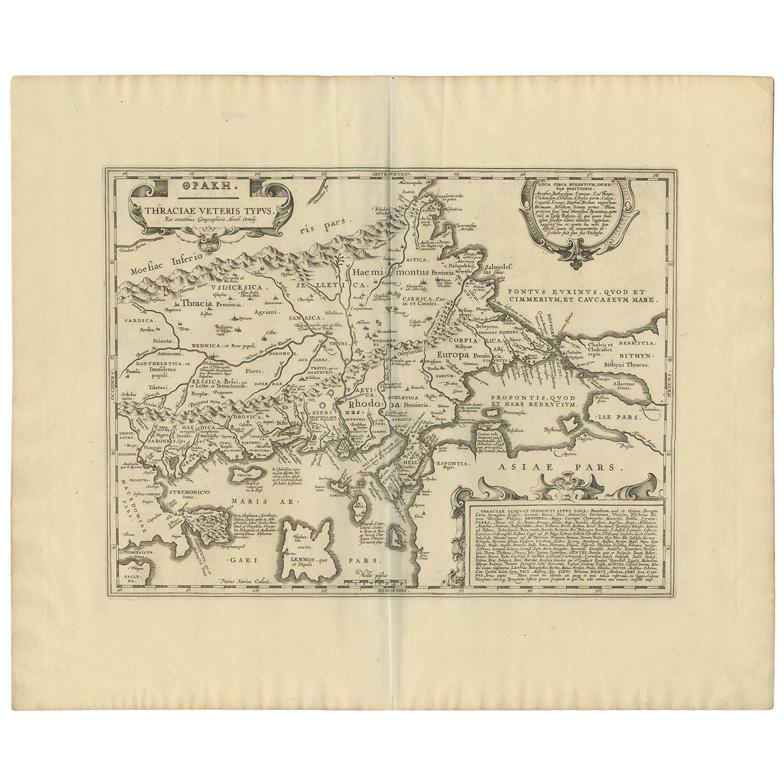
- Antique Map of Thracia ‘Greece’ by J. Janssonius, circa 1650Located in Langweer, NLThis antique map of Thracia is engraved and published by J. Janssonius after the cartographical sources by Abraham Ortelius. Ornated in the upper left corner with a title cartouche a...Category
Antique Mid-17th Century Maps
MaterialsPaper


You May Also Like
- 1657 Janssonius Map of Vermandois and Cappelle, Ric. A-004Located in Norton, MA1657 Janssonius map of Vermandois and Cappelle Ric.a004 Description: Antique map of France titled 'Descriptio Veromanduorum - Gouvernement de la Cappelle'. Two detailed maps o...Category
Antique 17th Century Unknown Maps
MaterialsPaper
- 17th Century Hand-Colored Map of a Region in West Germany by JanssoniusBy Johannes JanssoniusLocated in Alamo, CAThis attractive highly detailed 17th century original hand-colored map is entitled "Archiepiscopatus Maghdeburgensis et Anhaltinus Ducatus cum terris adjacentibus". It was published ...Category
Antique Mid-17th Century Dutch Maps
MaterialsPaper
- Prussia, Poland, N. Germany, Etc: A Hand-colored 17th Century Map by JanssoniusBy Johannes JanssoniusLocated in Alamo, CAThis is an attractive hand-colored copperplate engraved 17th century map of Prussia entitled "Prussia Accurate Descripta a Gasparo Henneberg Erlichensi", published in Amsterdam by Joannes Janssonius in 1664. This very detailed map from the golden age of Dutch cartography includes present-day Poland, Latvia, Lithuania, Estonia and portions of Germany. This highly detailed map is embellished by three ornate pink, red, mint green and gold...Category
Antique Mid-17th Century Dutch Maps
MaterialsPaper
- 1861 Topographical Map of the District of Columbia, by Boschke, Antique MapLocated in Colorado Springs, COPresented is an original map of Albert Boschke's extremely sought-after "Topographical Map of the District of Columbia Surveyed in the Years 1856 ...Category
Antique 1860s American Historical Memorabilia
MaterialsPaper
- 1907 Map of Colorado, Antique Topographical Map, by Louis NellLocated in Colorado Springs, COThis highly detailed pocket map is a topographical map of the state of Colorado by Louis Nell from 1907. The map "has been complied from all availabl...Category
Antique Early 1900s American Maps
MaterialsPaper
- Antique Map of Italy by Andriveau-Goujon, 1843By Andriveau-GoujonLocated in New York, NYAntique Map of Italy by Andriveau-Goujon, 1843. Map of Italy in two parts by Andriveau-Goujon for the Library of Prince Carini at Palazzo Carini i...Category
Antique 1840s French Maps
MaterialsLinen, Paper


Recently Viewed
View AllMore Ways To Browse
Antique Death
Jans Antiques
Jan Book
15c Antique Furniture
17th Century Plate Set
Antique Bookseller
Antique Booksellers
Johannes Engravings
Antique Metal Watering Can
Antique Metal Watering Cans
Mercator Map
Mercator Antique
Antique Map Set
Atlas Book
Set Of Antique Maps
Map Hondius
Map Print Set
Antique Map Schenk