
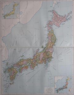
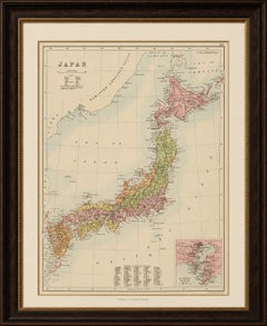
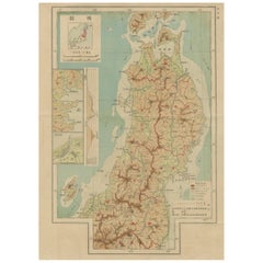
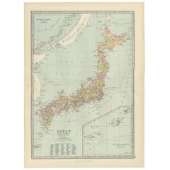
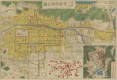
Large Original Vintage Map of Japan, circa 1920
Located in St Annes, Lancashire
Great map of Japan Original color. Good condition Published by Alexander Gross Unframed.
Category
Vintage 1920s English Maps
Materials
Paper
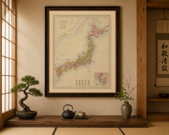
Large Original Vintage Map of Japan, circa 1920
Located in St Annes, Lancashire
Great map of Japan Original color. Good condition Published by Alexander Gross Unframed.
Paper

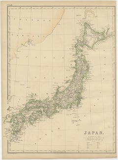
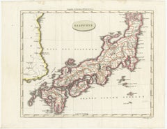
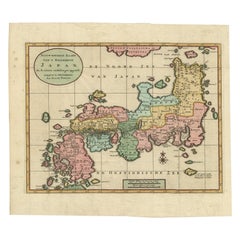
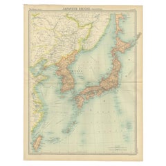
Large Original Vintage Map of Japan, circa 1920
Located in St Annes, Lancashire
Great map of Japan Unframed Original color By John Bartholomew and Co.
Paper
$176Sale Price|25% Off
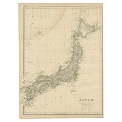
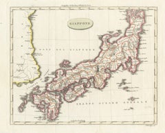
Antique Map of Japan by W. G. Blackie, 1859
Located in Langweer, NL
Antique map titled 'Japan'. Original antique map of Japan.
Paper
$329Sale Price|20% Off
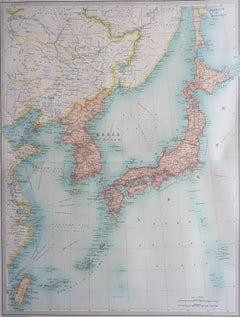
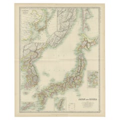
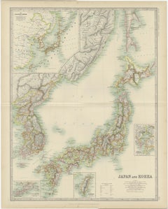
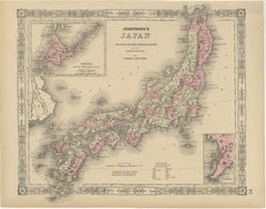
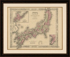
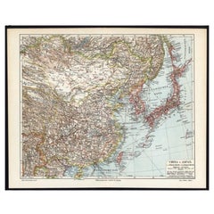
Antique Map of Japan and Korea by Johnston '1909'
Located in Langweer, NL
Antique map titled 'Japan and Korea'. Original antique map of Japan and Korea.
Paper


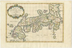
Antique Map of Japan by J.N. Bellin, 1752
Located in Langweer, NL
Bellin's wonderfully detailed map of Japan from the atlas of Prevost d'Exiles' influential collection of travel narratives, Histoire Generale des Voyages.
Paper
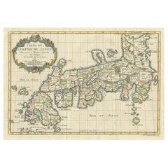
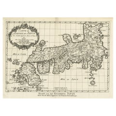
Attractive Hand-Tinted Antique Map of Japan, Published in 1752
Located in Langweer, NL
Nice decorative hand tinted map of Japan with the title (in French): Carte de L'Empire du Japon Bellin, 1752 This antique map is engraved with very attractive title cartouche.
Paper
Antique Map of Japan with Tokyo Inset, Black’s General Atlas, 1885
Located in Langweer, NL
Antique Map of Japan with Tokyo Inset, Black’s General Atlas, 1885 A finely engraved and delicately hand-colored antique map of Japan, published by the respected Scottish cartograph...
Paper
Antique Map of Japan & Coast of Korea named “Giappone” by Barbiellini, 1807
Located in Langweer, NL
Keywords: Japan map, Giappone, Carlo Antonio Barbiellini, Milan map, Italian cartography, antique Japan map, Edo Japan, East Asia map, Korea coastline, Nippon, Japanese provinces, hi...
Paper
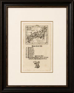
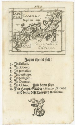
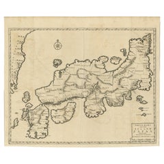
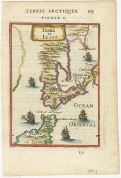
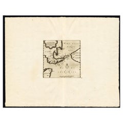
Rare 1683 Mallet Miniature Map of Japan “Iaponia” with German Text
Located in Langweer, NL
The piece is sold unframed; any framed images are shown for presentation and interior inspiration only and may not always be to scale with the original. Keywords: Japan, Iaponia, Ni...
Paper
Antique Map of Japan, Korea & the Chinese Coast by Bellin, circa 1755
Located in Langweer, NL
Keywords: Japan map, Giappone, Carlo Antonio Barbiellini, Milan map, Italian cartography, antique Japan map, Edo Japan, East Asia map, Korea coastline, Nippon, Japanese provinces, hi...
Paper
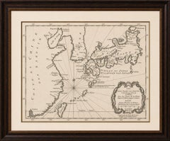
Antique Map of Japan with Scale and Compass Rose, c.1730
Located in Langweer, NL
Antique map titled 'Naauwkeurige Kaart van 'T Keizerryk Japan (..).'
Paper
Antique Map of Japan by Johnson & Ward, Decorative Civil War Era Atlas Map, 1865
Located in Langweer, NL
Antique Map of Japan by Johnson & Ward, Decorative Civil War Era Atlas Map Fine and highly decorative antique map of Japan titled “Johnson’s Japan, Nippon, Kiusiu, Sikok, Yesso and ...
Paper

$2,115Sale Price|20% Off
Rare Antique Map of Japan with Place Names Given in Dutch Nomenclature, 1726
Located in Langweer, NL
Antique map titled 'Nieuwe Kaart van het Eyland Japan'.
Paper

$940Sale Price|20% Off
Antique Map of Japan and Korea by Sanson, 'c.1690'
Located in Langweer, NL
Antique map titled 'Les Iles du Iapon (..)'. Original antique map, with beautiful (later) hand coloring, of Japan and the Island of Corey (Korea).
Paper
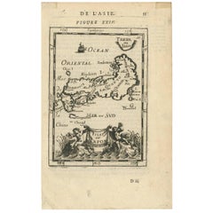

Antique Map of Japan by Allain Manesson Mallet, France, 1683
Located in Langweer, NL
A charming late 17th century French map with a very decorative title cartouche showing trumpet-blowing cherubs, by Allain Manneson Mallet (1630-1706), a well traveled military engine...
Paper

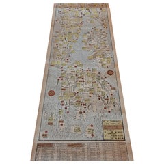
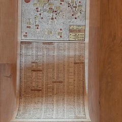
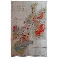
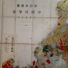
Set of 11 Antique Maps of Japan Originating from a Japanese Atlas, 1906
Located in Langweer, NL
Set of 11 antique maps depicting various regions of Japan. These maps originate from a Japanese atlas, dated 1906.
Paper

Antique Map of Japan, the Kurile Islands and Liu Kiu Islands, 1886
Located in Langweer, NL
The map is an exquisite piece, showcasing Japan's vibrant geography.
Paper
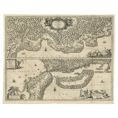

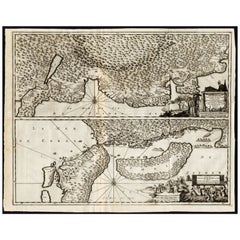
Map of Japanese Coast from Osaka to Tokyo & the Kyushu and Shikoku Islands, 1669
Located in Langweer, NL
Two maps on one sheet. The top map shows the Japanese coast from Osaka to Tokyo (Jedo).
Paper
$2,056Sale Price|30% Off
Antique Japanese Woodblock Print Map, Paper, Circa 1860, Large Size
Located in Langweer, NL
Original Japanese woodblock print map of Japan. Very large and fascinating map, rebacking with Japanese paper.
Paper
Antique Political Map of the Japanese Empire, 1922
Located in Langweer, NL
Antique map of Japan titled 'Japanese Empire - Political Map'.
Paper

$117Sale Price|44% Off
Antique Map of the Region of Tokyo and Nagasaki in Japan, 1922
Located in Langweer, NL
Antique map of Japan titled 'Japan - Environs of Tokio & Nagasaki'.
Paper
$620Sale Price|20% Off
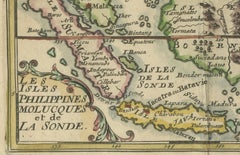
1692 Jacq. Peeters Map: East Indies, Indonesia, Japan, Philippines and Singapore
Located in Langweer, NL
1692 Jacques Peeters Map: East Indies, Indonesia & Japan with Unique Inset This hand-colored map from 1692, created by Jacques Peeters, captures the islands of Indonesia, the Ph...
Paper
Japanese Isles Map by Mallet, 1683 – Decorative Miniature Map
Located in Langweer, NL
1683 Map of Japan Isles by Mallet – Decorative Miniature Map This is an original antique map titled “Isles du Japon,” created by Alain Manesson Mallet and published in Paris in 1683.
Paper
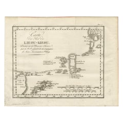
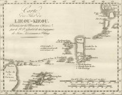
Antique Map of the Ryukyu Islands – Map of the Islands of Lieou-Kieou, c.1760
Located in Langweer, NL
Map of the Ryukyu Islands – “Carte des Isles de Lieou-Kieou”, c.1760 This rare 18th-century copperplate map, titled Carte des Isles de Lieou-Kieou, presents the Ryukyu Islands (toda...
Paper
Antique Japanese Map of Europe, Russo-Japanese War, Meiji 1904
Located in Langweer, NL
Antique Japanese Map of Europe, Russo-Japanese War, Meiji 1904 This striking and historically charged Japanese map of Europe was issued in 1904 (Meiji 37) at the outbreak of the Rus...
Paper
Antique Folding Map of Kyoto, Japan, 1920
Located in Langweer, NL
Antique folding map of Kyoto, Japan. On the verso of this map photos of buildings, other structures and informative text can be found.
Paper

$893Sale Price|20% Off
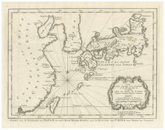
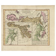
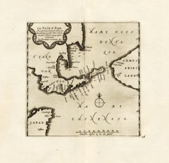
Map of North and East coast of Asia with Japan & inset maps of Kamchatka, c1750
Located in Langweer, NL
Map the north and east coast of Asia, showing an oddly shaped Japan and inset maps of Kamchatka.
Paper
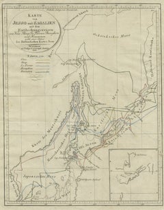
Antique Map of the Region of Hokkaido, Island of Japan, 1812
Located in Langweer, NL
Antique map titled 'Karte von Jesso und Sagalien'. Old map of the region of the island of Yesso (Mororan, Hokkaido, Japan).
Paper
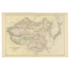
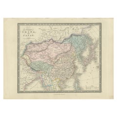
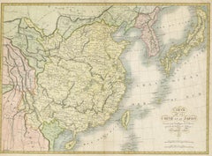
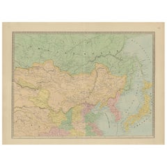
Old Map of the Chinese Empire and Japan, 1882
Located in Langweer, NL
An original antique map titled "The Chinese Empire and Japan," dating from an 1882 atlas by Blackie & Son.
Paper

$211Sale Price|40% Off
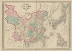
Antique Map of China and Japan by Wyld '1845'
Located in Langweer, NL
Antique map titled 'Map of the Empires of China and Japan'.
Paper

$282Sale Price|20% Off
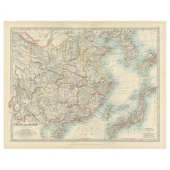
Antique Map of China and Japan by Johnson, 1872
Located in Langweer, NL
Antique map titled 'Johnson's China and Japan'. Map of China and Japan, with an inset map of the vicinity of Canton and Hong Kong.
Paper

$376Sale Price|20% Off
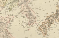
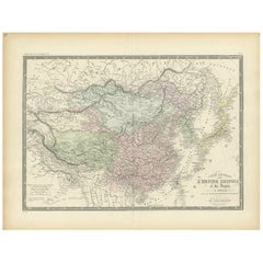
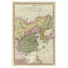
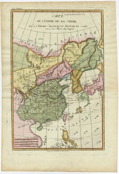
Antique Map of the Chinese Empire and Japan, 1875
Located in Langweer, NL
Large map of the Chinese Empire and Japan. This map originates from 'Atlas de Géographie Moderne Physique et Politique' by A.
Paper

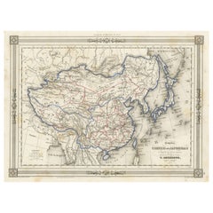
Antique Map of China and Japan by Tardieu, 1821
Located in Langweer, NL
Antique map titled 'Carte de la Chine et du Japon'. Detailed map of China, showing Korea, Japan and Taiwan.
Paper

$79Sale Price|20% Off
Antique Map of China and Japan by Meyer, 1895
Located in Langweer, NL
Antique map titled 'China und Japan'. Map of China, Mongolia, Taiwan and Japan.
Paper

$159Sale Price|20% Off
Antique Map of China and Japan, with Frame Style Border
Located in Langweer, NL
Antique map titled 'Empires Chinois et Japonnais'. Attractive map of China and Japan.
Paper
$1,645Sale Price|20% Off
Historical Large Map of Kyoto, Japan (1905) - Published by Kobayashi
Located in Langweer, NL
Old map of Kyoto, Japan. Published by Kobayashi, 1905.
Paper

$75Sale Price|20% Off
German Antique Map of China And Japan by Meyer, 1902
Located in Langweer, NL
Antique map titled 'China und Japan.' (Map of China and Japan).
Paper
$272Sale Price|20% Off
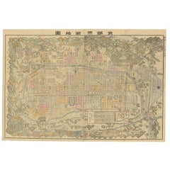
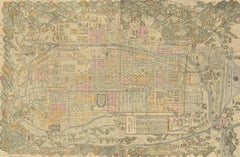
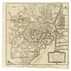
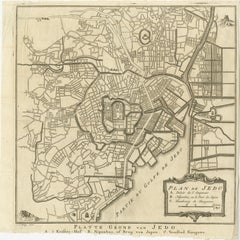
Antique Street Map of the City of Edo 'Modern Tokyo' in Japan
Located in Langweer, NL
A detailed street map of the city of Edo (modern Tokyo) in Japan, originally engraved by Bellin and Schley and reissued for Dutch editions of Prévost's monumental 'l'Histoire Géneral...
Paper
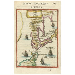
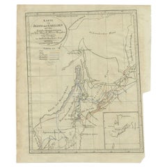
1685 Alain Manesson Mallet Map of Hokkaido (Lesso) in Northern Japan
Located in Langweer, NL
Instead, use archival-quality corner mounts or Japanese paper hinges to secure the map without causing damage.
Paper
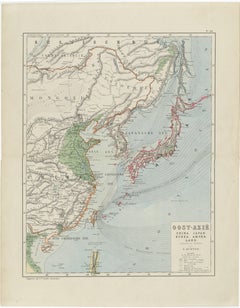
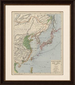
Antique Map of East Asia, Japan & Korea by J. Kuijper, circa 1860
Located in Langweer, NL
Keywords: Japan map, China map, Korea map, East Asia map, Oost-Azië, Jacob Kuijper, J.
Paper
Antique Map of China, Taiwan, Korea, Hong-Kong and Japan, 1903
Located in Langweer, NL
Antique Map of China, Taiwan, Korea, Hong-Kong and Japan, 1903 Description: This antique map, titled "India (Southern Sheet) and the South Eastern Provinces," was engraved and publi...
Paper
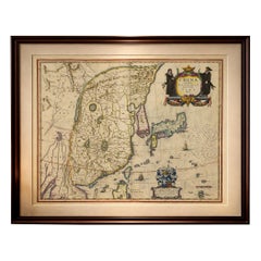

Antique Blaeu Map of China, Japan & Korea, Exotic Cartouches & Ships, c.1642
Located in Langweer, NL
Antique Blaeu Map of China, Japan & Korea, Exotic Cartouches & Ships, c.1642 A highly desirable and visually striking map of East Asia, centered on China and extending to Ko...
Paper
$756Sale Price|34% Off
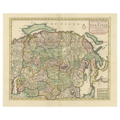
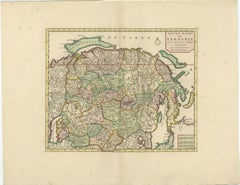
Antique Map of Northern Asia, with Russia, Korea and Northern Japan
Located in Langweer, NL
Antique map titled 'Nieuwe Kaart van Tartarie'. Map op Siberia and Chinese tartary.
Paper


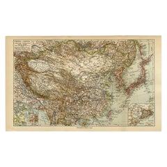
Antique Map of China and Japan by A.K. Johnston, 1865
Located in Langweer, NL
Antique map titled 'China and Japan'. Depicting Eastern China, the Islands of Japan and more.
Paper


Antique Map of the Chinese Empire and Japan by Lapie, 1842
Located in Langweer, NL
Map of the Chinese Empire (China) and Japan. This map originates from 'Atlas universel de géographie ancienne et moderne (..)' by Pierre M.
Paper
Antique Map of Chinese and Independent Tartary, Korea and Japan, 1806
Located in Langweer, NL
Beautiful map of Chinese Tartary, Korea and Japan. Artists and Engravers: John Cary (1755-1835) was a British cartographer and publisher best known for his clean engraving and di...
Paper
$893Sale Price|20% Off
Antique Map of the Region of Wakayama, Nara and Osaka 'Japan', ca.1880
Located in Langweer, NL
Geological folding map of the area with Wakayama, Nara, Osaka, Mie, and Shiga in Japan, circa 1880: This map is a geological folding map, which means it was designed to be portable ...
Linen, Paper

Antique Map of the Region of Osaka and Hirado Island in Japan, 1725
By Pieter Van Der Aa
Located in Langweer, NL
Two maps on one sheet. The upper map shows the region of Osaka, Japan.
Paper
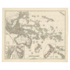
Map of Australia, New Zealand, Part of China, Japan and Southeast Asia, 1857
Located in Langweer, NL
German Antique map titled 'Australien'. Map of Australia, New Zealand, part of China, Japan and Southeast Asia.
Paper
$611Sale Price|20% Off
Decorative Map of the Empire of China, Korea, Japan, Taiwan, Lucon, Macau, 1780
Located in Langweer, NL
Decorative map of the Empire of China, depicting China, Corea ( Korea ), Japan, Tonquin and the Philippine island Lucon.
Paper
Extremely Rare Map of The land of Eso or Hokkaido in Japan, 1725
Located in Langweer, NL
Depending on the individual map, presentation, and context, a rare or antique map can be modern, traditional, abstract, figurative, serious or whimsical.
Paper
Antique Map of China, Japan & Korea – Eastern Asia by Andriveau-Goujon, 1860
Located in Langweer, NL
Antique Map of China, Japan & Korea – Eastern Asia by Andriveau-Goujon, 1860 This beautifully hand-colored antique map, titled “Carte de la Chine, de la Corée et du Japon,” was publ...
Paper


Antique Map of China, Korea, Japan and the Northern Philippines, circa 1780
Located in Langweer, NL
Interesting and detailed map of China, Korea, Japan and the Northern Philippines.
Paper

$789Sale Price|20% Off
Original Antique Map of the Empire of Japan, Centered on the Bay of Osaka, c1752
Located in Langweer, NL
Map of the Empire of Japan. Centered on the Bay of Osaka, this map covers from Hirado (here identified as I.
Paper

$206Sale Price|20% Off
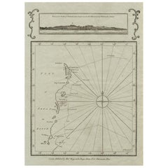
Old Map of the East Coast of Honshu with an Inset, Japan, c.1785
Located in Langweer, NL
Antique map titled ‘Part of Japan or Nippon'. View of the Coast of Japan when we first saw it: The Hill a bearing West 3 miles distant.
Paper

$3,781Sale Price|35% Off
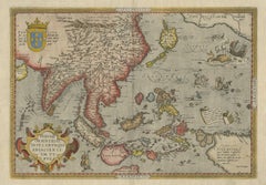
Antique Ortelius Map of Asia Featuring Japan, China, Taiwan & East Indies, 1587
By Abraham Ortelius
Located in Langweer, NL
Ortelius Asia Japan China Taiwan Philippines East Indies Antique Map 1570 This highly important early map of Asia titled “Indiae Orientalis Insularumque Adiacientium Typus” is one o...
Paper

$488Sale Price|20% Off
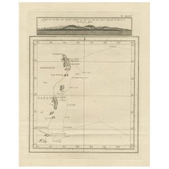
Map of the East Coast of Hanshu or Honshu & a View of the Japanese Coast, 1803
Located in Langweer, NL
Antique map titled 'Gedeelte van Japan of Nipon'. Map of the east coast of Hanshu, with a view of the Japanese coast titled 'Gezigt van de Kust van Japan, wanneer wij haar voor h...
Paper
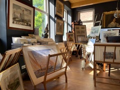
Antique and vintage collectibles and curiosities can bring whimsy and wonder to any interior.
Decorating with old scientific instruments, historical memorabilia and vintage musical instruments, as well as other authentic collectibles and curiosities that can be found on 1stDibs, presents an opportunity to create a unique, natural history museum-like atmosphere in your home that can provoke conversation as often as it pays tribute to how far we’ve come in understanding our world.
And bringing collectibles and curiosities into your space is actually on trend — Wunderkammern, or curiosity cabinets, were all the rage in Europe during the 1500s and continued to have adherents there and in the U.S. in the following centuries. Today, however, they’re experiencing a real surge in popularity and influencing how many interior designers are furnishing and decorating homes — combining contemporary with antique, scientific with tribal, earthly with extraterrestrial, Les Lalanne tables with Flemish tapestries.
The original Wunderkammern were entire rooms filled with objects demonstrating their owners’ worldly knowledge: A proper one included artificiala or preciosa (objets d’art); naturalia (such as skeletons, shells, minerals); exotica (taxidermy or dried plants); and scientifica (scientific instruments), frequently alongside religious relics and ancient artifacts.
Pay tribute to a history of rich and diverse musical traditions that have taken shape all over the world by decorating your home with a collection of antique and vintage musical instruments — with a little help from strong hanging wire or some wall hooks, vintage brass instruments such as a gong, French horn or trumpet can help elevate a home office or complement the efforts you’ve made to ensure a welcoming vibe in your home’s entryway. Bells or antique wind instruments can add provocative metallic contrasts to dark woods as tabletop decorative objects.
Create an intriguing focal point with Georgian scientific instruments, such as stick barometers with mahogany cases or lacquered brass telescopes. These items stem from an era named for the monarchies of the four King Georges, who ruled England in succession starting in 1714 (plus King William’s reign, which lasted until 1837). Just as there was beautiful jewelry produced during the period that today is coveted by collectors, there is much to be found in the collectibles and curiosities realm too.
Wanderlust, nostalgia and a shared love of good design are contributing factors to certain trends in decorating — just as vintage trunks and luggage have reappeared as furniture or home accents in a bedroom or foyer, decorating with globes, maps or nautical objects is similarly rooted in the allure of travel and a penchant for the stylish finishing touch that collectibles bring to our homes.
Find a wide range of antique and vintage collectibles and curiosities on 1stDibs.
It’s never too early for good design. These interiors combine elevated furnishings and a youthful spirit, resulting in spaces that are at once elegant and whimsical.
Produced in 1843, the well-preserved volume is evidence of the author's exacting specifications.
New or old, the coverlets add old-time charm to any space.
Get into the games! These items celebrate the events, athletes, host countries and sporting spirit.
French trendsetter and serial collector Daniel Rozensztroch tells us about his obsession with objects related to seafaring men.
It's hard to resist the allure of a beautiful pool. So, go ahead and daydream about whiling away your summer in paradise.
The sought-after designer worked with the team at Hoffman Creative to produce a monograph that beautifully showcases some of Studio Shamshiri's most inspiring projects.
Italian writer and collector Umberto Pasti opens the doors to his remarkable cave of wonders in North Africa.