Pierre Mortier Landscape Prints
Dutch, 1661-1711
Pierre Mortier, also referred to as Pieter Mortier, was a Dutch designer. He was known for his activity as a bird's eye map illustrator.
to
2
Overall Width
to
Overall Height
to
5
182
169
146
131
2
2
2
2
Artist: Pierre Mortier
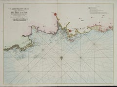
Carte Particuliere Des Coste De Bretagne qui Comprend Morlaix
By Pierre Mortier
Located in Paonia, CO
Carte Particuliere Des Costes De Bretagne qui Comprend Morlaix, Saint Paul de Leon, les Sept Isles, et L’Isle. Faite par ordre Exprez Du Roy de France is from the collection of ch...
Category
1690s Pierre Mortier Landscape Prints
Materials
Engraving
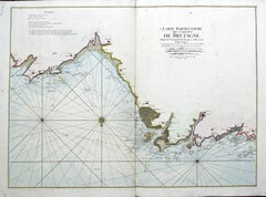
Carte Particular Des Costes De Bretagne Depuis le Cap de Frehel, Jusques a Perros
By Pierre Mortier
Located in Paonia, CO
Carte Particulaire Des Costes De Bretagne Depuis Le Cap de Frehel, Jusques a Perros, & L’Isle Tome. This large sea scale chart shows part of the northwestern co...
Category
1690s Pierre Mortier Landscape Prints
Materials
Engraving
Related Items
A View of Dover, England: A Framed 19th C. Engraving After J. M. W. Turner
By J.M.W. Turner
Located in Alamo, CA
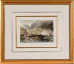
This beautiful 19th century framed engraving "Dover" by Thomas Lupton is based on an original painting by the renowned British artist J.M.W. Turner, which depicts a panoramic view of the harbor of Dover, a town in southeastern England, that has been an important port for centuries. The engraving captures the dramatic sky and sea that Turner was known for, with billowing clouds and waves crashing against the shore. The town and its famous white cliffs are visible in the background, while ships and boats dot the harbor in the foreground. Several wooden rowboats...
Category
Mid-19th Century Romantic Pierre Mortier Landscape Prints
Materials
Engraving
$460 Sale Price
20% Off
H 18 in W 20.5 in D 1 in
A View of Kauai, Hawaii Discovered by Captain Cook: Original 18th C. Engraving
By John Webber
Located in Alamo, CA
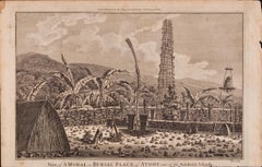
"View of A Morai or Burial Place of Atooi, One of the Sandwich Islands (Kauai, Hawaii)" is an original 18th century engraving from a drawing by John Webber (1751-1793), who was the a...
Category
1780s Pierre Mortier Landscape Prints
Materials
Engraving
$180 Sale Price
20% Off
H 9.75 in W 15.25 in
Fishing Off Hastings, England: A Framed 19th C. Engraving After J. M. W. Turner
By J.M.W. Turner
Located in Alamo, CA
This beautiful 19th century framed engraving "Line Fishing Off Hastings" by William Miller is based on an original painting by the renowned British artist J.M.W. Turner, which depicts a scene of fishermen at work off the coast of the town of Hastings in East Sussex, England. The Miller engraving faithfully reproduces Turner's painting, capturing the same atmospheric quality and sense of motion. In the foreground of the image, a group of fishermen are shown in a small boat, with one man using a fishing line to catch fish. In the background, there is a larger ship, along with a view of the town of Hastings and the cliffs beyond. Overall, the Miller engraving "Line Fishing Off Hastings" is a beautiful and detailed representation of Turner's original painting, and provides a glimpse into life in a 19th century fishing community.
This colorful 19th century engraving is presented in a gold-colored wood frame and a cream-colored French mat highlighted with a light blue band and thinner mustard and gold-colored bands. There is a gold-colored fillet which further embellishes the engraving. The frame measures 18" high, 20.5" wide and 1" deep. The engraving, frame and mat are in excellent condition.
Joseph Mallord William (J.M.W.) Turner (1775-1851) was an English painter who is widely considered one of the greatest landscape painters in Western art history. Born in London, he showed a remarkable talent for art from a young age, and studied at the Royal Academy of Arts from the age of 14. He quickly gained recognition for his watercolor landscapes, which were highly innovative and expressive. Turner's style evolved over time, and he became increasingly interested in the effects of light and color. He traveled extensively throughout Europe, and his experiences of the natural world, particularly the sea and the sky, had a profound influence on his art. His paintings are known for their luminosity, atmospheric effects, and dramatic use of color. Despite facing criticism and ridicule from some of his contemporaries, Turner continued to push the boundaries of art, experimenting with new techniques and styles throughout his career. He was a prolific artist, creating thousands of paintings, sketches, and watercolors, and his legacy continues to inspire artists today.
William Miller (1796-1882) was an English engraver and publisher, best known for his work in reproducing the paintings of J.M.W. Turner. Miller was born in Bristol and began his career as an engraver at a young age, working for a variety of publications and artists. In the early 1820s, Miller began working with Turner, engraving many of the artist's most famous works, including "The Fighting Temeraire...
Category
Mid-19th Century Romantic Pierre Mortier Landscape Prints
Materials
Engraving
$460 Sale Price
20% Off
H 18 in W 20.5 in D 1 in
The Fighting Temeraire: A Framed 19th C. Engraving After J. M. W. Turner
By J.M.W. Turner
Located in Alamo, CA
This beautiful 19th century framed engraving "The Fighting Temeraire" by James Tibbetts Willmore is based on an original painting by the renowned British artist J.M.W. Turner. It was published by James S. Virtue & Co. in London between 1859-1875. It depicts the once mighty British warship the HMS Temeraire being towed away down the river Thames by a much smaller steamboat to a ship-breaking yard to be broken up for scrap. The Temeraire was first launched in 1798 and represented the pinnacle of British ship-building. 180-feet long, constructed of English oak and armed with 98 guns, she was one of the largest warships of the period. The Temeraire became a symbol of British pride and military power that endured throughout the 19th century. The man-of-war served during the French Revolutionary and Napoleonic Wars and was among the last serving ships to have been at the Battle of Trafalgar in 1805. It became one of the many older ships put out of service in the 1830s and 1840s. The once mighty and feared ship symbolizes a once magnificent, but now obsolete, technology. Turner seems to lament her inglorious final journey, being towed by a less magnificent, but modern steam powered tugboat.
The Turner painting was created in 1838 and is now held in the National Gallery in London. Willmore's engraving, created in 1859, captures the dramatic scene with great detail and skill. The image has become an iconic representation of the decline of Britain's naval power and the transition from sail to steam in the 19th century. The sunset in the background is symbolic of the sun going down on British naval power and tradition. The painting conveys profound and diverse themes that are central to the human experience: those of mortality and change, technology and progress, heroism and brutality. The painting demonstrates Turner’s skill as an artist. His ability to produce scenes of great beauty that are dramatic, but are also symbolic, stimulating both thoughtful analysis, as well as emotion. Turner's painting was voted by the British public in a 2005 BBC radio sponsored survey to be the British people's favorite painting of all time. In 2020 it was included on a new British banknote...
Category
Mid-19th Century Romantic Pierre Mortier Landscape Prints
Materials
Engraving
$540 Sale Price
20% Off
H 18 in W 20.5 in D 1 in
Surrender of Tahiti to Captain Wallis: An Original 18th C. Engraving
By John Webber
Located in Alamo, CA
"A Representation of the Surrender of the Island of Otaheite to Capt.n Wallis, by the Supposed Queen of Oberea" is an original 18th century engraving created by Sparrow, from a drawi...
Category
1780s Pierre Mortier Landscape Prints
Materials
Engraving
$200 Sale Price
20% Off
H 9.5 in W 15.25 in
Sandwich Islands Canoe (Hawaii): Framed 18th C. Engraving Captain Cook's Journal
By John Webber
Located in Alamo, CA
"A Canoe of the Sandwich Islands, the Rowers Masked" is an engraving created by Charles Grignion, from a drawing by John Webber (1752-1793), who was the artist on Captain James Cook's 3rd and final voyage of discovery. It is Plate 65 in the atlas of "A Voyage to the Pacific Ocean Undertaken by the Command of His Majesty, for Making Discoveries in the Northern Hemisphere", the official British Admiralty sanctioned journal published upon completion of the voyage in London in 1784 by Strahan & Cadell.
This famous image of ten Hawaiian rowers transporting a priest who is carrying a feather-covered image of Kukailimoku, the Hawaiian god of war. The priests and paddlers are all wearing gourd masks in their double-hulled canoe with an upright lateen woven sail. Each hull was shaped from a single large Koa log harvested from island rainforests, where they were carved before being transported to the coast.
This engraving is presented in a Koa wood frame and a white mat. There are occasional faint spots, but the print is otherwise in very good condition. Koa is the same wood as was used to make the canoe. Koa wood is legendary in Hawaii. Not only is this amazing wood native to Hawaii, but it is known for the deep rich colors and varied grain pattern. Koa has an honored heritage in Hawaii and is highly revered and sacred. The word “koa” means “warrior” in Hawaiian. The warriors of King Kamehameha the Great, created canoes and weapons from a wood plentiful on the Big Island of Hawaii. This wood became synonymous with the warriors themselves, and it became known as koa. The frame measures 20.75" high, 26.75" wide and 0.88" deep.
There are three other engravings listed from the official journal of Captain Cook's 3rd voyage available that are presented in identical Koa wood frames and mat (LU117324682022, LU117324684052, LU117324684062). They would make a wonderful grouping for a display of 2, 3 or 4 prints. A discount is available for a grouping depending on the number of items included.
Hawaii was discovered by Captain Cook (1728-1779) during this voyage. Hawaii was originally called The Sandwich Islands in honor of The Earl of Sandwich...
Category
1780s Pierre Mortier Landscape Prints
Materials
Engraving
$2,060 Sale Price
20% Off
H 20.75 in W 26.75 in D 0.88 in
A View of Scarborough, England: A Framed 19th C. Engraving After J. M. W. Turner
By J.M.W. Turner
Located in Alamo, CA
This beautiful 19th century framed engraving "Scarborough" by W. Chapman is based on an original painting by the renowned British artist J.M.W. Turner. It was published in London by ...
Category
Mid-19th Century Romantic Pierre Mortier Landscape Prints
Materials
Engraving
$460 Sale Price
20% Off
H 18.25 in W 20.88 in D 1 in
St. Michael's Mount, Cornwall: A Framed 19th C. Engraving After Myles Foster
By Myles Birket Foster
Located in Alamo, CA
This beautiful 19th century framed hand-colored engraving is entitled "St. Michael's Mount, Cornwall" by J. Saddler after an original painting by the British artist Myles Birket Fost...
Category
Mid-19th Century Romantic Pierre Mortier Landscape Prints
Materials
Engraving
$460 Sale Price
20% Off
H 14.38 in W 17.88 in D 1.5 in
View of Meissen, Germany: A 16th Century Hand-colored Map by Braun & Hogenberg
By Franz Hogenberg
Located in Alamo, CA
This is a 16th century original hand-colored copperplate engraved map of View of View of Meissen, Germany entitled "Misena Hermun Duvorum Urbs" by Georg Braun & Franz Hogenberg, from their famous city atlas "Civitates Orbis Terrarum", published in Cologne, Germany in 1575.
The map depicts a side view and bird's-eye view, looking across the Elbe River (labelled Albis Fluvius on the map; White River in Latin) from the northeast. In the foreground are three women in conversation on a hill above the city, along with a man and a woman in conversation by a road, all dressed in contemporary costumes of the upper class. A coat-of-arms is present in each upper corner. A great castle sits atop a hill in the background on the left. Meissen grew up around Albrechtsburg castle, built by Emperor Henry I around AD 929, and was granted a municipal charter at the end of the 12th century. From 1471 onwards, the castle complex was reconstructed as the residence of the Saxon electors on the northeast corner of the Domberg (Cathedral Hill). Meissen cathedral is a Gothic hall church begun c. 1270; in 1413 a bolt of lightning destroyed its west towers, which were replaced only in the 20th century. Meissen lies to the northwest of Dresden, Germany in Saxony. Meissen is famous for its Meissen porcelain and the Albrechtsburg castle
The following is an English translation of an excerpt from Braun's description of the city: "This city is surrounded by very many rivers, to the east flows the Elbe, to the south the Triebisch, to the west are the mountains, to the north the Meisse, after which the city is said to be named. The city is well-situated in its surroundings, the navigable rivers, the mountains and the healthy air. Around the city there is a good land to grow grain, fertile vineyards on the hillsides and without doubt the mountains are not without ore, for one mile away, up the Elbe, is Scharfenberg, where silver and lead ore are mined.."
References: Van der Krogt 4, 2684; Taschen, Braun and Hogenberg...
Category
16th Century Old Masters Pierre Mortier Landscape Prints
Materials
Engraving
$780 Sale Price
20% Off
H 15.75 in W 21.25 in
Three 19th C. Hand Colored Engravings of London Architecture by T. Shepherd
By Thomas Hosmer Shepherd
Located in Alamo, CA
A set of three hand-colored engravings from "Metropolitan Improvements; or London in the Nineteenth Century", published in London, England in 1828. The scenes were drawn by Thomas Ho...
Category
1820s Realist Pierre Mortier Landscape Prints
Materials
Engraving
$775
H 12.5 in W 13.75 in D 0.63 in
Map of the World: An Original 18th Century Hand-colored Map by E. Bowen
Located in Alamo, CA
This is an original 18th century hand-colored map entitled "A New & Correct Chart of All The Known World Laid down according to Mercator's Projection" by Emanuel Bowen. It was published in 1744 in London in John Harris's "Navigantium atque Itinerantium Bibliotheca" or "A Complete Collection of Voyages and Travels". This highly detailed and colorful map depicts the world. as it was known in the mid 18th century. A majority of the northern and central portions of Canada and America are left blank due to the purity of knowledge at the time this map was published.
The map is embellished with four Compass Roses in the lower left, lower center, lower right and center, along with many rhumb lines. There a is a decorative title cartouche in the upper left. This colorful, attractive, historical and interesting 1744 map presents the entire world on Mercator's projection as it was understood in the middle part of the 18th century, before the landmark explorations of Captain’s Cook, Vancouver, Wilkes and others. It is an example of a nautical chart, a type of map that was designed specifically for use by mariners. The map is centered on the equator and includes both the Eastern and Western Hemispheres. The continents of North America, South America, Europe, Africa, and Asia are depicted, as well as various islands in the Atlantic, Pacific, and Indian Oceans. The map is laid out according to the Mercator projection, a type of cylindrical map projection that was developed in the 16th century by Flemish cartographer Gerardus Mercator. This projection has the advantage of preserving angles and shapes, making it useful for navigation. The map presents a paucity of inland detail, particularly for the Americas, but major cities, geographical landmarks, and regions are included. Ocean currents and Tradewinds are identified, as well as the magnetic declination lines or magnetic variance, which refers to the difference between true north and compass north. The continents are color coded, enhancing the beauty of this map. The three compass roses indicate the directions of the cardinal points.
The depiction of the western coast of America, the Pacific and Australia are interesting. There was very little exploration of Australia between the navigations of William Damper in 1699 and Tobias Furneaux in 1773. Most of the maps detail relies on the 17th century Dutch expeditions to Australia's western coast, by Abel Tasman and William Janszoon. Van Diemen's Land (Tasmania) and New Guinea appear connected to the Australian continent. New Zealand appears as a single landmass. North of New Zealand there is a landmass labelled 'Ter d' St. Esprit' which probably represents the New Hebrides Islands. This map precedes the accurate exploration of the South Pacific and east coast of Australia by Captain James Cook later in the 18th century. The map includes ‘Drakes' Port,' the site where Sir Francis Drake supposedly landed in 1579 during his 1579 circumnavigation of the globe. Here he claimed territory for England, restocked, and repaired his vessels. Drake named the region New Albion. The exact location of Drake's Port is a cartographic mystery. Drake's Harbor is believed to be in the region of San Francisco Bay, Bodega Bay, San Pablo Bay...
Category
Mid-18th Century Old Masters Pierre Mortier Landscape Prints
Materials
Engraving
$1,020 Sale Price
20% Off
H 15.75 in W 19.63 in
Europe: An Original 18th Century Hand-colored Map by E. Bowen
Located in Alamo, CA
This is an original 18th century hand-colored map entitled "A New & Accurate Map of Europe Drawn from the Best Authorities Assisted by the Most Improved Modern Charts and Maps." by E...
Category
Mid-18th Century Old Masters Pierre Mortier Landscape Prints
Materials
Engraving
$940 Sale Price
20% Off
H 15.75 in W 19 in
Previously Available Items
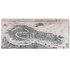
Veduta di Venezia Stampa Antica Incisa su Rame Acquaforte 1724 Pierre Mortier
By Pierre Mortier
Located in Milano, IT
Venezia Stampa Antica Incisa Acquaforte 1724 Mortier. Questa veduta veneziana è una delle più suggestive e affascinanti piante prospettiche della città di Venezia, incisa su rame al...
Category
1720s Flemish School Pierre Mortier Landscape Prints
Materials
Etching
H 28.35 in W 51.58 in D 1.19 in
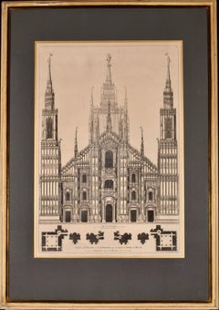
Milan Cathedral: A Framed 1704 Architectural Rendering by Mortier after Blaeu
By Pierre Mortier
Located in Alamo, CA
This is an architectural engraving depicting the front of the famous cathedral in Milan (Duomo di Milano), Italy entitled "Face de L'Eglise de St. Ambriose qu'on Appelle le Dome de Milan" by Pierre Mortier (1661-1711) in 1704 after a 17th century engraving by Joan Blaeu (1596-1673), from Blaeu's publication "Nouveau Théâtre D'Italie, Ou Description Exacte De Ses Villes, Palais, Églises, Principaux Édifices" (New Theater or Townbooks of Italy).
In 1672 Blaeu's printing house was destroyed by fire, and Mortier took over what was left of Blaeu's plates. New plates were engraved, and Mortier re-issued Blaeu's Townbooks of Italy with a mixture of the old and the new panoramas of Italian towns and cities.
This engraving is presented in an antiqued bleached wood...
Category
Early 18th Century Old Masters Pierre Mortier Landscape Prints
Materials
Engraving
H 33.75 in W 23.63 in D 1.25 in
Pierre Mortier landscape prints for sale on 1stDibs.
Find a wide variety of authentic Pierre Mortier landscape prints available for sale on 1stDibs. You can also browse by medium to find art by Pierre Mortier in engraving and more. Much of the original work by this artist or collective was created during the 18th century and earlier and is mostly associated with the Old Masters style. Not every interior allows for large Pierre Mortier landscape prints, so small editions measuring 24 inches across are available. Customers who are interested in this artist might also find the work of Johann Baptist Homann, Charles Amand Durand, and Samuel & Nathaniel Buck. Pierre Mortier landscape prints prices can differ depending upon medium, time period and other attributes. On 1stDibs, the price for these items starts at $1,350 and tops out at $1,420, while the average work can sell for $1,350.
