
William Hodges Prints and Multiples

to
2
1
2
1
1
2
Overall Height
to
Overall Width
to
1
1
1
1
2
1
2
3
986
695
659
626
3
Artist: William Hodges
India William Hodges 'The East End of the Fort of Mongheer' India Engraving
By William Hodges
Located in Norfolk, GB
Aquatint with soft ground etching from the seminal publication, Selected Views in India, drawn on the Spot, in the Years 1780, 1781, 1782 and 1783, and Executed in Aquatint in 1786 -...
Category

Late 18th Century Other Art Style William Hodges Prints and Multiples

Materials

Engraving

India William Hodges 'A View of the Ravines at Etana' Early India Engraving
By William Hodges
Located in Norfolk, GB
William Hodges Plate 27 'A View of the Ravines at Etawa' Published 20th May 1787 by J Wells, 22 Charing Cross. Page size, 16.5” x 22.5”, image 11.25 x 18” Aquatint with soft gro...
Category

Early 2000s Other Art Style William Hodges Prints and Multiples

Materials

Engraving

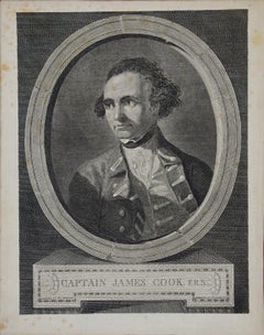
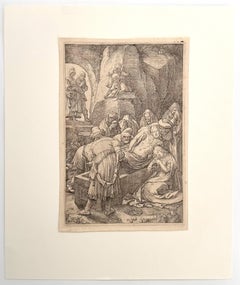
Captain James Cook: 18th C. Portrait by William Hodges After Cook's 2nd Voyage
By William Hodges
Located in Alamo, CA
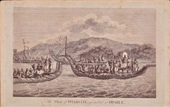
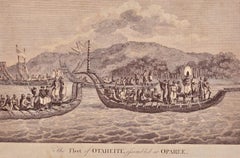
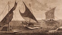
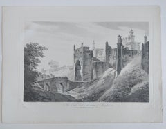
This is an original 18th Century copper plate engraved portrait of Captain James Cook as a young man. It was engraved by J. Basire after a painting by William Hodges, published in London by W. Strahan and T. Cadell in the Strand in 1777 as the frontispiece to the official journal publication of Cook's 2nd voyage of discovery, "A voyage towards the South Pole, and round the World. Performed in His Majesty's ships the Resolution and Adventure, in the years 1772, 1773, 1774, and 1775". The journal was written by James Cook, Commander of the Resolution, which was the ship used for the voyage and William Hodges, who was the artist on board the ship. This famous image has been used in many articles and tributes to Captain Cook, including a Norfolk Island stamp celebrating his many accomplishments. This engraved head-and-shoulders portrait of Captain Cook is enclosed in an oval with the appearance of a stone border. Captain Cook is dressed in his naval dress uniform, with a topcoat over a lace shirt. The engraving is printed on watermarked laid, chain-linked paper. The sheet measures 11.5" high x 9" wide. There is some spotting, most prominently in the margins. The print is otherwise in excellent condition. Captain James Cook (1728-1779) was an English explorer, navigator, surveyor and cartographer, who dramatically changed what was known about the world through his three voyages of discovery in the 1770's. Cook's achievements are too numerous to include here, but for example, Cook charted much of the Pacific Ocean and discovered many island groups, including the Hawaiian islands, which he named the Sandwich Islands, in honor of the head of the British Admiralty and a patron of Cook's. Cook was the first European to explore the eastern coast of Australia, and he was the first to map the New Zealand coastline. He sailed farther south than any other explorer before him, disproving the belief that a huge land mass occupied the South Pole. He also explored the northwest coast of North America, including present day Alaska and adjacent portions of Russia. He proved that the Northwest Passage did not exist. Cook was an exceptional seaman, navigator and leader of men, which contributed to the success of his explorations, but also saved his ship and crew on many occasions when faced with challenges, such as storms in previously unexplored waters, like occurred in the Great Barrier Reef off the eastern coast of Australia. He is also the first to require his crew to eat citrus fruit which markedly reduced the incidence of survey, which had led to large scale illness and death during earlier ocean voyages. As outstanding as Cook's skills were, they are even more impressive since they were self-taught. Having grown up the son of a farmhand in Northern England he had only four years of formal schooling. He taught himself astronomy, mathematics and other disciplines which were helpful when he continued his education, first in the merchant marine and then in the British Navy. Cook's adventurous career came to a sudden and unfortunate end in 1779, when he was killed in a confrontation with Hawaiian natives...
Category

1770s William Hodges Prints and Multiples

Materials

Engraving

Related Items
View of Pisaro, Italy: A 16th Century Hand-colored Map by Braun & Hogenberg
By Franz Hogenberg
Located in Alamo, CA
This is a 16th century original hand-colored copperplate engraved map of View of Pezaro (Pisaro), Italy entitled "Pisaurum vulgo Pezaro" by Georg Braun & Franz Hogenberg, from their famous city atlas "Civitates Orbis Terrarum", published in Augsberg, Germany in 1575. The map depicts a view of Pesaro, Italy from the west looking over the town to the Adriatic Sea. The River Foglia flows into the Adriatic in the foreground. The only identifiable building is the cathedral of San Domenico, which rises above the other roofs with its tall spire. Two women, dressed in styles of the 16th century are in conversation on a hill in the foreground on the left. Pesaro is in the province of Pesaro and Urbino and lies on the Adriatic and east of Florence. The city, which was founded by the Etruscans and named Pisaurum by the Romans, belonged from AD 754 onwards to the Papal States, and after 1285 was controlled by the princely families of Malatesta, Sforza and della Rovere. Today it is the capital of the province of Pesaro and Urbino and has a population of about 92,000. Pesaro's most famous resident, composer Gioacchino Rossini, was born here in 1792. The following is an English translation of an excerpt from Braun's description of the city: "We believe that the astonishingly short life of the inhabitants of Pesaro comes not only from the insalubrious air, but also from the great quantity of delectable and delicious fruits which they consume to excess. For this causes the production in their bodies of evil humours, which then lead to incurably fatal diseases. The area around the city is most charming and well planted with vineyards, fig trees, olive trees and other fruit-bearing trees." 
  References: Van der Krogt 4, 3369, state 1; Taschen, Braun and Hogenberg...
Category

16th Century Old Masters William Hodges Prints and Multiples

Materials

Engraving

Frankfort, Germany: A 16th Century Hand-colored Map by Braun & Hogenberg
By Franz Hogenberg
Located in Alamo, CA
This is a 16th century original hand-colored copperplate engraved map of Frankfort, Germany entitled "Francenbergum, vel ut alij Francoburgum Hassiae Opp" by Georg Braun & Franz Hogenberg, from their famous city atlas "Civitates Orbis Terrarum", published in Cologne, Germany in 1595. This is an English translation of an excerpt from the original text in the atlas: "Frankenberg or, according to others, Francoburgum, a town in Hesse. Charlemagne vested the town of Frankenberg with many freedoms and privileges, which it still enjoys to this day, and on account of its valiant and victorious soldiers awarded a signet, upon which there formerly appeared a golden castle with a tower, together with the letter F and a golden crown. Frankenberg, seen here from the northeast, lies on a hill above the River Eder. The hillside is covered with fields neatly separated by bushes and fences. Soaring above the town is the massive Liebfrauenkirche, which was modelled on St Elizabeth's church in Marburg. The New Town was founded in 1335 at the foot of the hill (right) and merged with the Old Town as late as 1556. Frankenberg was founded by Conrad of Thuringia in 1233/34 to prevent the archbishops of Mainz from expanding their sphere of influence...
Category

16th Century Old Masters William Hodges Prints and Multiples

Materials

Engraving

View of Emden, Germany: A 16th Century Hand-colored Map by Braun & Hogenberg
By Franz Hogenberg
Located in Alamo, CA
This is a 16th century original hand-colored copperplate engraved map of a bird's-eye View of Embden, Germany entitled " Emuda, vulgo Embden vrbs Frisia orientalis primaria" by Georg Braun & Franz Hogenberg, in volume II of their famous city atlas "Civitates Orbis Terrarum", published in Cologne, Germany in 1575. This is a beautifully colored and detailed map of Emden, a seaport in northwestern Germany, along the Ems River and perhaps portions of over Dollart Bay, near the border with the Netherland. The map depicts a bird's-eye view of the city from the southwest, as well as a view of the harbor and an extensive system of canals. Numerous ships of various sizes, as well as two rowboats containing numerous occupants are seen in the main waterway in the foreground and additional boats line two canals in the center of the city. Two men and two women are shown on a hill in the foreground on the right, dressed in the 16th century style of nobility. Two ornate crests are included in each corner. A title strap-work cartouche is in the upper center with the title in Latin. The crest on the right including Engelke up de Muer (The Little Angel on the Wall) was granted by Emperor Maximilian I in 1495. This is an English translation of an excerpt of Braun's description of Embden: "In Emden, the capital of East Frisia, rich merchants live in very fine houses. The city has a broad and well-situated harbour, which in my opinion is unique in Holland. Frisia and the whole of the Netherlands, for the ships can anchor here right under the city walls. They have also extended the harbour as far as the New Town, so that up to 400 ships can now find shelter here when the sea is rough." The emphasis on the harbor and waterways within the city highlights the importance of Emden's place as a seaport at this time. Embden developed from a Dutch/Flemish trading settlement in the 7th-8th centuries into a city as late as late 14th century. In 1494 it was granted staple rights, and in 1536 the harbour was extended. In the mid-16th century Emden's port was thought to have the most ships in Europe. Its population then was about 5,000, rising to 15,000 by the end of the 16th century. The Ems River flowed directly under the city walls, but its course was changed in the 17th century by the construction of a canal. Emden has canals within its city limits, a typical feature of Dutch towns, which also enabled the extension of the harbor. In 1744 Emden was annexed by Prussia and is now part of Germany. It was captured by French forces in 1757 during the Seven Years' War, but recaptured by Anglo-German forces in 1758. During the Napoleonic French era, Emden and the surrounding lands of East Frisia were part of the short-lived Kingdom of Holland. References:Van der Krogt 4, 1230, State 2; Taschen, Braun and Hogenberg...
Category

16th Century Old Masters William Hodges Prints and Multiples

Materials

Engraving

Map of the World: An Original 18th Century Hand-colored Map by E. Bowen
Located in Alamo, CA
This is an original 18th century hand-colored map entitled "A New & Correct Chart of All The Known World Laid down according to Mercator's Projection" by Emanuel Bowen. It was published in 1744 in London in John Harris's "Navigantium atque Itinerantium Bibliotheca" or "A Complete Collection of Voyages and Travels". This highly detailed and colorful map depicts the world. as it was known in the mid 18th century. A majority of the northern and central portions of Canada and America are left blank due to the purity of knowledge at the time this map was published. The map is embellished with four Compass Roses in the lower left, lower center, lower right and center, along with many rhumb lines. There a is a decorative title cartouche in the upper left. This colorful, attractive, historical and interesting 1744 map presents the entire world on Mercator's projection as it was understood in the middle part of the 18th century, before the landmark explorations of Captain’s Cook, Vancouver, Wilkes and others. It is an example of a nautical chart, a type of map that was designed specifically for use by mariners. The map is centered on the equator and includes both the Eastern and Western Hemispheres. The continents of North America, South America, Europe, Africa, and Asia are depicted, as well as various islands in the Atlantic, Pacific, and Indian Oceans. The map is laid out according to the Mercator projection, a type of cylindrical map projection that was developed in the 16th century by Flemish cartographer Gerardus Mercator. This projection has the advantage of preserving angles and shapes, making it useful for navigation. The map presents a paucity of inland detail, particularly for the Americas, but major cities, geographical landmarks, and regions are included. Ocean currents and Tradewinds are identified, as well as the magnetic declination lines or magnetic variance, which refers to the difference between true north and compass north. The continents are color coded, enhancing the beauty of this map. The three compass roses indicate the directions of the cardinal points. The depiction of the western coast of America, the Pacific and Australia are interesting. There was very little exploration of Australia between the navigations of William Damper in 1699 and Tobias Furneaux in 1773. Most of the maps detail relies on the 17th century Dutch expeditions to Australia's western coast, by Abel Tasman and William Janszoon. Van Diemen's Land (Tasmania) and New Guinea appear connected to the Australian continent. New Zealand appears as a single landmass. North of New Zealand there is a landmass labelled 'Ter d' St. Esprit' which probably represents the New Hebrides Islands. This map precedes the accurate exploration of the South Pacific and east coast of Australia by Captain James Cook later in the 18th century. The map includes ‘Drakes' Port,' the site where Sir Francis Drake supposedly landed in 1579 during his 1579 circumnavigation of the globe. Here he claimed territory for England, restocked, and repaired his vessels. Drake named the region New Albion. The exact location of Drake's Port is a cartographic mystery. Drake's Harbor is believed to be in the region of San Francisco Bay, Bodega Bay, San Pablo Bay...
Category

Mid-18th Century Old Masters William Hodges Prints and Multiples

Materials

Engraving

Christuskopf (Christ Head) /// German Expressionism Karl Schmidt-Rottluff
By Karl Schmidt-Rottluff
Located in Saint Augustine, FL
Artist: Karl Schmidt-Rottluff (German, 1884-1976) Title: "Christuskopf (Christ Head)" Portfolio: Das Spiel Christa vom Schmerz der Schönheit des Weibes (The Play Christa from the Pain of the Beauty of the Woman) *Issued unsigned Year: 1918 Medium: Original Woodcut Engraving on wove paper Limited edition: Unknown Printer: Fritz Voigt, Berlin, Germany Publisher: Verlag Die Aktion, Berlin, Germany Reference: Schapire No. 227, page 46; Jentsch No. 35. Rifkind No. 2563; Lang No. 300; Reed No. 118 Overall size with attached page: 8.5" x 10.63" Sheet size: 8.5" x 5.38" Image size: 3.63" x 3.38" Condition: Toning to sheet (as normal). One tiny pinhole top margin. In very good condition Very rare Notes: Provenance: private collection - Oxnard, CA. Comes from a complete originally bound 48 page folio with 9 original woodcut engravings by Schmidt-Rottluff. Text by Alfred Brust. Presently attached to its accompanying page which is actually the title page. The cover page in pictures is not included, only for reference/provenance. There is an example of this work in the permanent collection of the Brücke Museum, Berlin, Germany. Biography: Karl Schmidt-Rottluff (born December 1, 1884, Rottluff, near Chemnitz, Germany—died...
Category

1910s Expressionist William Hodges Prints and Multiples

Materials

Engraving, Woodcut

A View of Scarborough, England: A Framed 19th C. Engraving After J. M. W. Turner
By J.M.W. Turner
Located in Alamo, CA
This beautiful 19th century framed engraving "Scarborough" by W. Chapman is based on an original painting by the renowned British artist J.M.W. Turner. It was published in London by ...
Category

Mid-19th Century Romantic William Hodges Prints and Multiples

Materials

Engraving

Ulysses Deriding Polyphemus: A Framed 19th C. Engraving After J. M. W. Turner
By J.M.W. Turner
Located in Alamo, CA
This beautiful 19th century framed hand-colored engraving/etching entitled "Ullyses Deriding Polyphemus" by Edward Goodall is based on an original 1829 painting by the renowned Briti...
Category

Mid-19th Century Romantic William Hodges Prints and Multiples

Materials

Engraving, Etching

The Fighting Temeraire: A Framed 19th C. Engraving After J. M. W. Turner
By J.M.W. Turner
Located in Alamo, CA
This beautiful 19th century framed engraving "The Fighting Temeraire" by James Tibbetts Willmore is based on an original painting by the renowned British artist J.M.W. Turner. It was published by James S. Virtue & Co. in London between 1859-1875. It depicts the once mighty British warship the HMS Temeraire being towed away down the river Thames by a much smaller steamboat to a ship-breaking yard to be broken up for scrap. The Temeraire was first launched in 1798 and represented the pinnacle of British ship-building. 180-feet long, constructed of English oak and armed with 98 guns, she was one of the largest warships of the period. The Temeraire became a symbol of British pride and military power that endured throughout the 19th century. The man-of-war served during the French Revolutionary and Napoleonic Wars and was among the last serving ships to have been at the Battle of Trafalgar in 1805. It became one of the many older ships put out of service in the 1830s and 1840s. The once mighty and feared ship symbolizes a once magnificent, but now obsolete, technology. Turner seems to lament her inglorious final journey, being towed by a less magnificent, but modern steam powered tugboat. The Turner painting was created in 1838 and is now held in the National Gallery in London. Willmore's engraving, created in 1859, captures the dramatic scene with great detail and skill. The image has become an iconic representation of the decline of Britain's naval power and the transition from sail to steam in the 19th century. The sunset in the background is symbolic of the sun going down on British naval power and tradition. The painting conveys profound and diverse themes that are central to the human experience: those of mortality and change, technology and progress, heroism and brutality. The painting demonstrates Turner’s skill as an artist. His ability to produce scenes of great beauty that are dramatic, but are also symbolic, stimulating both thoughtful analysis, as well as emotion. Turner's painting was voted by the British public in a 2005 BBC radio sponsored survey to be the British people's favorite painting of all time. In 2020 it was included on a new British banknote...
Category

Mid-19th Century Romantic William Hodges Prints and Multiples

Materials

Engraving

Canterbury: An Original 16th C. Framed Hand-colored Map by Braun & Hogenberg
By Franz Hogenberg
Located in Alamo, CA
This is a framed 16th century map and city view of Canterbury, England entitled "Cantuarbury" by Braun & Hogenburg, from their famous landmark atlas of city views 'Civitates Orbis Terrarum' (Atlas of the Cities of the World), which was first published in Cologne, Germany in 1572. The map of Canterbury was first published in 1588. It depicts a detailed birdseye view of the completely walled and fortified city of Canterbury, with its cathedral the most prominent feature. The coat of arms of England, Canterbury, and the Archbishop of Canterbury are included. This beautifully hand-colored map is presented in a gold-colored wood frame with a beaded inner trim and a paprika-colored mat that highlights details in the map. The frame measures 18.75" high by 22.25" wide by 0.875" deep. There is a central vertical fold, as issued. The map is in excellent condition. Braun and Hogenberg's 'The Civitates Orbis Terrarum' was the second atlas of maps ever published and the first atlas of cities and towns of the world. It is one of the most important books published in the 16th century. Most of the maps in the atlas were engraved by Franz Hogenberg and the text, with its descriptions of the history and additional factual information of the cities, was written by a team of writers and edited by Georg Braun. The work contained 546 bird-eye views and map views of cities and towns from all over the world. It gave graphic representation of the main features of the illustrated cities and towns, including the buildings and streets. Although the ordinary buildings are stylized, the principal buildings are reproduced from actual drawings created on location. The principal landmarks and streets can still be recognized today. In addition, the maps often include the heraldic arms of the city, the nature of the surrounding countryside, the important rivers, streams and harbors, even depicting stone bridges, wooden pontoons, flat-bottomed ferries, ships and working boats, wharves and jetties, as well as land-based activities, including horsemen, pedestrians, wagons, coaches, and palanquins. Small vignettes are often included which illustrate the trade, occupations and habits of the local inhabitants, such as agriculture, paper-making and textiles, as well as local forms of punishment, such as gibbets, wheels, floggings etc. Large figures dressed in their local costume are often presented out of proportion in the foreground. The aim of the authors was to give as much information as possible in a pleasing visual form. They succeeded in creating maps that were both informative and decorative works of art. The atlas is a wonderful glimpse of life in medieval Europe. Georg Braun (1541-1622) was German Catholic...
Category

16th Century Old Masters William Hodges Prints and Multiples

Materials

Engraving

St. Michael's Mount, Cornwall: A Framed 19th C. Engraving After Myles Foster
By Myles Birket Foster
Located in Alamo, CA
This beautiful 19th century framed hand-colored engraving is entitled "St. Michael's Mount, Cornwall" by J. Saddler after an original painting by the British artist Myles Birket Fost...
Category

Mid-19th Century Romantic William Hodges Prints and Multiples

Materials

Engraving

Fishing Off Hastings, England: A Framed 19th C. Engraving After J. M. W. Turner
By J.M.W. Turner
Located in Alamo, CA
This beautiful 19th century framed engraving "Line Fishing Off Hastings" by William Miller is based on an original painting by the renowned British artist J.M.W. Turner, which depicts a scene of fishermen at work off the coast of the town of Hastings in East Sussex, England. The Miller engraving faithfully reproduces Turner's painting, capturing the same atmospheric quality and sense of motion. In the foreground of the image, a group of fishermen are shown in a small boat, with one man using a fishing line to catch fish. In the background, there is a larger ship, along with a view of the town of Hastings and the cliffs beyond. Overall, the Miller engraving "Line Fishing Off Hastings" is a beautiful and detailed representation of Turner's original painting, and provides a glimpse into life in a 19th century fishing community. This colorful 19th century engraving is presented in a gold-colored wood frame and a cream-colored French mat highlighted with a light blue band and thinner mustard and gold-colored bands. There is a gold-colored fillet which further embellishes the engraving. The frame measures 18" high, 20.5" wide and 1" deep. The engraving, frame and mat are in excellent condition. Joseph Mallord William (J.M.W.) Turner (1775-1851) was an English painter who is widely considered one of the greatest landscape painters in Western art history. Born in London, he showed a remarkable talent for art from a young age, and studied at the Royal Academy of Arts from the age of 14. He quickly gained recognition for his watercolor landscapes, which were highly innovative and expressive. Turner's style evolved over time, and he became increasingly interested in the effects of light and color. He traveled extensively throughout Europe, and his experiences of the natural world, particularly the sea and the sky, had a profound influence on his art. His paintings are known for their luminosity, atmospheric effects, and dramatic use of color. Despite facing criticism and ridicule from some of his contemporaries, Turner continued to push the boundaries of art, experimenting with new techniques and styles throughout his career. He was a prolific artist, creating thousands of paintings, sketches, and watercolors, and his legacy continues to inspire artists today. William Miller (1796-1882) was an English engraver and publisher, best known for his work in reproducing the paintings of J.M.W. Turner. Miller was born in Bristol and began his career as an engraver at a young age, working for a variety of publications and artists. In the early 1820s, Miller began working with Turner, engraving many of the artist's most famous works, including "The Fighting Temeraire...
Category

Mid-19th Century Romantic William Hodges Prints and Multiples

Materials

Engraving

Tournai (Tournay), Belgium: A 16th Century Hand-colored Map by Braun & Hogenberg
By Franz Hogenberg
Located in Alamo, CA
This is a 16th century original hand-colored copperplate engraved map of Tournai, Belgium, entitled "Tornacum" by Georg Braun & Franz Hogenberg, in volume IV of their famous city atlas "Civitates Orbis Terrarum", published in Cologne or Augsberg, Germany in 1575. The map provides a bird's-eye view of the walled city of Tournai, the second oldest city in Belgium. It lies approximately one hour by car southwest of Brussels or from Ghent. The names of thirty of its streets, prominent buildings, churches and squares are listed in a key within a strap-work cartouche in the lower left. These locations are numbered in the key corresponding to their locations on the map. This colorful map of Tournai (Tornacum or Tournay as it was called in the 16th century) includes the title in Latin in a cartouche in the upper center. Three crests are present across the upper map. A man and two woman are standing on a hill in the foreground in the lower right dressed in the style of 16th century upper class residents of the town. This is an English translation of an excerpt of Braun's description of Tornai: “Tornacum or Turnacum is a city in Gallia Belgica, situated on the Schelde in the territory of the Nervii, called Tournai by its French inhabitants, but Dorneck by the Germans. Tournai has always been a large and powerful city, with an abundance of goods and commercial activities and wonderfully resourceful craftsmen, who invent new articles every day, and although some of these go out of use they constantly conceive of other new things, both useful and delightful, so that they have at all times something that provides work and a means of livelihood for the poor." ReferencesVan der Krogt 4, 4435, State 1; Taschen, Braun and Hogenberg...
Category

16th Century Old Masters William Hodges Prints and Multiples

Materials

Engraving

Previously Available Items
William Hodges India 'A View of the Fort of Bidjegur' Early India Engraving
By William Hodges
Located in Norfolk, GB
William Hodges 'A View of the Fort of Bidjegur' Published May 29th 1786 by J.Wells No:22 Charing Cross Image size 32.2 x 48.2 cm Aquatint with soft ground etching from the seminal ...
Category

Late 18th Century Other Art Style William Hodges Prints and Multiples

Materials

Engraving

William Hodges prints and multiples for sale on 1stDibs.

Find a wide variety of authentic William Hodges prints and multiples available for sale on 1stDibs. You can also browse by medium to find art by William Hodges in engraving and more. Not every interior allows for large William Hodges prints and multiples, so small editions measuring 9 inches across are available. Customers who are interested in this artist might also find the work of Henry Mayo Bateman, John Webber, and Guy Bardone. William Hodges prints and multiples prices can differ depending upon medium, time period and other attributes. On 1stDibs, the price for these items starts at $712 and tops out at $1,100, while the average work can sell for $712.

Recently Viewed

View All