Items Similar to The Orbits of Venus and Mercury: An 18th C. Framed Celestial Map by Doppelmayr


Want more images or videos?
Request additional images or videos from the seller
1 of 11
Johann Gabriel Doppelmayr 1The Orbits of Venus and Mercury: An 18th C. Framed Celestial Map by Doppelmayr1736
1736
About the Item
This 18th century hand-colored copperplate celestial map by Johann Doppelmayr entitled "Phænomena Motuum Irregularium quos Planetar inferiores Venus et Mercurius ad annum Salutis MDCCX," ("Regular Phenomena of the Lower Planetar Motions of Venus and Mercury for the Year 1710") was incorporated as plate 7 in 'Atlas Novus Coelestis in quo Mundus Spectabilis', first published in Nuremberg, Germany in 1735 in association with the heirs of the famous and prolific cartographer and printer Johann Baptist Homann. 'Atlas Novus Coelestis in Quo Mundus spectabilis, et in Eodem Tam Errantium Quam Inerrantium Stellarum Phoenomena notabilia, Circa Ipsarum lumen, figuram, faciem, motum, Eclipses.secundum Nic. Copernici, et Ex Parte Tychonis De Brahe, Hypothesin' (The New Atlas of the Celestial World in which the World is to be Looked at, and the Phenomena Notable in the Same of the Errants and the Inerrant Stars, with respect to their light, shape, face, motion, and eclipses according to Nic. Copernicus and Tycho De Brahe: Hypothesis) includes diagrams illustrating the planetery systems of Copernicus, Tycho, and Riccioli; the elliptic theories of Kepler, Boulliau, Seth Ward, and Mercator; the lunar theories of Tycho, Horrocks, and Newton; and Halley's cometary theory. This plate and others were originally created by Doppelmayr for scientific publication by the academic society Academiae Caesareae Leopoldino-Carolinae Naturae Curiosorum to show the movements of Mars, Saturn, Jupiter, Mercury, Venus and Earth according to Tycho Brahe (1546-1601), who combined Copernican and Ptolemaic astronomical systems in his attempt to explain the universe through observed data, including the orbits of the known planets at the time.
This celestial chart/map depicts the heliocentric motions of the planets Mercury and Venus during the year 1710, with two diagrams depicting the transit of Mercury across the Sun on November 5, 1710 and the predicted transit of Venus across the Sun on June 6, 1761, demonstrated through Copernican mathematical theories. The planets are illustrated in a vignette as allegorical figures in chariots; Venus (Aphrodite) accompanied by the moon is in a chariot drawn by six horses and driven by a child figure racing above the clouds. Mercury's (Hermes) chariot sits above clouds. It is driven by a putti and drawn by two birds. Above Mercury, Zeus (Jupiter) sits astride the sun. Zodiac symbols, including Leo and Cancer, are depicted above the vignette.
This framed 18th century double page hand-colored engraved celestial map is printed on chain-linked laid paper. It is presented in an attractive polished medium brown-colored frame with contrasting black inner and outer trim. The frame measures 31.13" high by 34.88" wide by 1" in depth. There are a few small frame abrasions. The double mat consists of a beige fabric outer mat and a cranberry-colored inner mat. There is a central fold, as issued with mild separation of the lower fold, but the visible portions of the print are otherwise in very good condition.
There are two other Doppelmayr/Homann celestial maps that are listed on our 1stdibs storefront that are presented in identical frames and maps. Two or three of these would make for an attractive and impressive display grouping. A discount will be extended for the purchase of multiple maps. Please reach out to us for more details about these striking and interesting celestial maps.
Johann Gabriel Doppelmayr (1677-1750) was a famous German geographer and astronomer, who was Professor of Mathematics at the Aegidien Gymnasium in Nuremberg, Germany. He wrote extensively on astronomy, geography, cartography, spherical trigonometry, sundials and mathematical and other scientific instruments and was involved in the production of terrestrial and celestial globes. He was a member of the Royal Society of London and the Berlin and St. Petersburg Academies of Sciences. In the early 1700s, Doppelmayr created astronomical and cosmological plates that were incorporated in atlases published by Johann Baptist Homann (1664-1724), first published in 1712 in Homann’s Atlas von hundert Charten and reprinted in his Grossen Atlas in 1716. They continued to be published after Homann's death by his heirs until 1848. Thirty of these plates were published in the Atlas Novus Coelestis in quo Mundus Spectabilis. Twenty of these plates focused on the cosmological systems of Copernicus and Tycho Brahe, as well as known details of the planets and other bodies in the solar system. The other ten plates focussed on constellations and the locations known stars and comets.
Johann Baptist Homann (1663-1724) was a mapmaker who founded a respected and prolific publishing company, which continued long after his death as Homann Heirs. Homann lived his entire life in Bavaria, particularly in Nuremberg. Initially, Johann trained to become a priest before converting to Protestantism and working as a notary. In 1702, Johann founded a publishing house that specialized in engravings. The firm flourished, becoming the leading map publisher in Germany and an important entity in the European map market. In 1715, Johann was named Imperial Geographer to the Holy Roman Empire by Charles VI and made a member of the Prussian Academy of Sciences. Most importantly for his business, his reputation and contacts gained him imperial printing privileges which protected his publications and recommended him to customers.
- Creator:Johann Gabriel Doppelmayr 1 (1677 - 1750, German)
- Creation Year:1736
- Dimensions:Height: 31.13 in (79.08 cm)Width: 34.88 in (88.6 cm)Depth: 1 in (2.54 cm)
- Medium:
- Period:
- Condition:
- Gallery Location:Alamo, CA
- Reference Number:
About the Seller
5.0
Vetted Seller
These experienced sellers undergo a comprehensive evaluation by our team of in-house experts.
Established in 2011
1stDibs seller since 2019
233 sales on 1stDibs
Typical response time: 1 hour
- ShippingRetrieving quote...Ships From: Alamo, CA
- Return PolicyA return for this item may be initiated within 7 days of delivery.
More From This SellerView All
- L'Isle de France: A Hand-colored 17th Century Map by De WitBy Frederick de WitLocated in Alamo, CAThis colorful and detailed 17th century hand-colored copperplate map by Frederick De Wit was published in Amsterdam between 1666 and 1760. The map depicts the Île-de-France, which is one of the ancient provinces of France. Paris is located in the center of the map, with Versailles to the southwest The map extends from Rouen in the west to Reims in the east. The area around Paris, the Véxin Français, was the original domain of the king of France. Other areas were ruled by French feudal lords. For example, the Véxin Normand area was the domain of the Duke of Normandy...Category
Early 18th Century Old Masters More Prints
MaterialsEngraving
- Map of the Russian Empire: An Original 18th Century Hand-colored Map by E. BowenLocated in Alamo, CAThis is an original 18th century hand-colored map entitled "A New & Accurate Map of The Whole Russian Empire, As Contain'd Both In Europe and Asia, Drawn from Authentic Journals, Sur...Category
Mid-18th Century Old Masters Landscape Prints
MaterialsEngraving
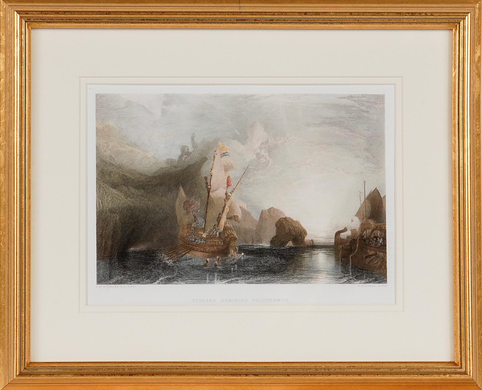
- Ulysses Deriding Polyphemus: A Framed 19th C. Engraving After J. M. W. TurnerBy J.M.W. TurnerLocated in Alamo, CAThis beautiful 19th century framed hand-colored engraving/etching entitled "Ullyses Deriding Polyphemus" by Edward Goodall is based on an original 1829 painting by the renowned Briti...Category
Mid-19th Century Romantic Landscape Prints
MaterialsEngraving, Etching
- View of Emden, Germany: A 16th Century Hand-colored Map by Braun & HogenbergBy Franz HogenbergLocated in Alamo, CAThis is a 16th century original hand-colored copperplate engraved map of a bird's-eye View of Embden, Germany entitled " Emuda, vulgo Embden vrbs Frisia orientalis primaria" by Georg Braun & Franz Hogenberg, in volume II of their famous city atlas "Civitates Orbis Terrarum", published in Cologne, Germany in 1575. This is a beautifully colored and detailed map of Emden, a seaport in northwestern Germany, along the Ems River and perhaps portions of over Dollart Bay, near the border with the Netherland. The map depicts a bird's-eye view of the city from the southwest, as well as a view of the harbor and an extensive system of canals. Numerous ships of various sizes, as well as two rowboats containing numerous occupants are seen in the main waterway in the foreground and additional boats line two canals in the center of the city. Two men and two women are shown on a hill in the foreground on the right, dressed in the 16th century style of nobility. Two ornate crests are included in each corner. A title strap-work cartouche is in the upper center with the title in Latin. The crest on the right including Engelke up de Muer (The Little Angel on the Wall) was granted by Emperor Maximilian I in 1495. This is an English translation of an excerpt of Braun's description of Embden: "In Emden, the capital of East Frisia, rich merchants live in very fine houses. The city has a broad and well-situated harbour, which in my opinion is unique in Holland. Frisia and the whole of the Netherlands, for the ships can anchor here right under the city walls. They have also extended the harbour as far as the New Town, so that up to 400 ships can now find shelter here when the sea is rough." The emphasis on the harbor and waterways within the city highlights the importance of Emden's place as a seaport at this time. Embden developed from a Dutch/Flemish trading settlement in the 7th-8th centuries into a city as late as late 14th century. In 1494 it was granted staple rights, and in 1536 the harbour was extended. In the mid-16th century Emden's port was thought to have the most ships in Europe. Its population then was about 5,000, rising to 15,000 by the end of the 16th century. The Ems River flowed directly under the city walls, but its course was changed in the 17th century by the construction of a canal. Emden has canals within its city limits, a typical feature of Dutch towns, which also enabled the extension of the harbor. In 1744 Emden was annexed by Prussia and is now part of Germany. It was captured by French forces in 1757 during the Seven Years' War, but recaptured by Anglo-German forces in 1758. During the Napoleonic French era, Emden and the surrounding lands of East Frisia were part of the short-lived Kingdom of Holland. References:Van der Krogt 4, 1230, State 2; Taschen, Braun and Hogenberg...Category
16th Century Old Masters Landscape Prints
MaterialsEngraving
- Ireland: A Framed 17th Century Hand-colored Map by Jan JannsonBy Johannes JanssoniusLocated in Alamo, CAThis is a 17th century hand-colored map entitled "Hibernia Regnum Vulgo Ireland" by Johannes Janssonius's (Jan Jansson), published in Amsterdam in 1640. This highly detailed map depicts the Emerald Isle with an extensive display of towns, roads, mountains, rivers, lakes and county borders, etc. It includes two decorative cartouches on the left. The title cartouche includes the Irish harp and the second, in the upper left, includes a lion wearing a crown on the left, a unicorn on the right and a coat-of-arms in the middle, which includes another Irish harp. A distance scale is seen in the lower right, augmented with two putti. The map is embellished with three sailing ships and a sea monster. Western portions of Scotland and England...Category
Mid-17th Century Old Masters Landscape Prints
MaterialsEngraving
- View of Meissen, Germany: A 16th Century Hand-colored Map by Braun & HogenbergBy Franz HogenbergLocated in Alamo, CAThis is a 16th century original hand-colored copperplate engraved map of View of View of Meissen, Germany entitled "Misena Hermun Duvorum Urbs" by Georg Braun & Franz Hogenberg, from their famous city atlas "Civitates Orbis Terrarum", published in Cologne, Germany in 1575. The map depicts a side view and bird's-eye view, looking across the Elbe River (labelled Albis Fluvius on the map; White River in Latin) from the northeast. In the foreground are three women in conversation on a hill above the city, along with a man and a woman in conversation by a road, all dressed in contemporary costumes of the upper class. A coat-of-arms is present in each upper corner. A great castle sits atop a hill in the background on the left. Meissen grew up around Albrechtsburg castle, built by Emperor Henry I around AD 929, and was granted a municipal charter at the end of the 12th century. From 1471 onwards, the castle complex was reconstructed as the residence of the Saxon electors on the northeast corner of the Domberg (Cathedral Hill). Meissen cathedral is a Gothic hall church begun c. 1270; in 1413 a bolt of lightning destroyed its west towers, which were replaced only in the 20th century. Meissen lies to the northwest of Dresden, Germany in Saxony. Meissen is famous for its Meissen porcelain and the Albrechtsburg castle The following is an English translation of an excerpt from Braun's description of the city: "This city is surrounded by very many rivers, to the east flows the Elbe, to the south the Triebisch, to the west are the mountains, to the north the Meisse, after which the city is said to be named. The city is well-situated in its surroundings, the navigable rivers, the mountains and the healthy air. Around the city there is a good land to grow grain, fertile vineyards on the hillsides and without doubt the mountains are not without ore, for one mile away, up the Elbe, is Scharfenberg, where silver and lead ore are mined.." References: Van der Krogt 4, 2684; Taschen, Braun and Hogenberg...Category
16th Century Old Masters Landscape Prints
MaterialsEngraving


You May Also Like
- India William Hodges 'The East End of the Fort of Mongheer' India EngravingBy William HodgesLocated in Norfolk, GBAquatint with soft ground etching from the seminal publication, Selected Views in India, drawn on the Spot, in the Years 1780, 1781, 1782 and 1783, and Executed in Aquatint in 1786 -...Category
Late 18th Century Other Art Style Landscape Prints
MaterialsEngraving
- India William Hodges 'A View of the Ravines at Etana' Early India EngravingBy William HodgesLocated in Norfolk, GBWilliam Hodges Plate 27 'A View of the Ravines at Etawa' Published 20th May 1787 by J Wells, 22 Charing Cross. Page size, 16.5” x 22.5”, image 11.25 x 18” Aquatint with soft gro...Category
Early 2000s Other Art Style Landscape Prints
MaterialsEngraving
- Persiae, Armeniae, Natoliae et Arabiae Descriptio per Frederick deWit 1666 mapLocated in Paonia, COMap of Persiae, Armeniae, Natoliae et Arabiae Descriptio per F de Wit 1688 engraving from: Atlas Contractus Orbis Terrarum Praecipuas ac Novissimas Complectens Tabulas. Amsterdam, N. Visscher, 1656-77. (Koeman III, Vis5-8) This highly decorative map of the Middle East is by the Dutch engraver, publisher, and map seller...Category
1660s Realist Landscape Prints
MaterialsEngraving
- A View at Bolcheretzko (Russia) 1784 Captains Cook Final Voyage by John WebberBy John WebberLocated in Paonia, COA View at Bolcheretzko (Russia) is from the 1784 First Edition Atlas Accompanying Capt. James Cook and King; Third and Final Voyage of Captain James Cook.John Webber (1752-1793) was ...Category
1780s Realist Landscape Prints
MaterialsEngraving
- AYX Map of Aix en Provence, France by J. Blaeu 17th c.By Joan (Johannes) BlaeuLocated in Paonia, CODetailed plan of Aix en Provence, in France. This print is a hand -colored double sheet engraving by the famous cartographer Joan (Johannes) Blaeu ( 1596 - 1673 ). The left side ...Category
Late 17th Century Other Art Style Landscape Prints
MaterialsEngraving
- Map of the County of Buckingham From an Actual SurveyLocated in Paonia, COCartographers Christopher (1786-1855) and John (1791-1867) Greenwood were surveyors from Yorkshire, who undertook an ambitious project to produce a series of large-scale maps of the counties of England, Wales and Scotland.The maps represent a remarkable and impressive surveying achievement forming an important record of the counties depicted. In the years 1817-1832 the Greenwood brothers published the Atlas of The Counties of England from an Actual Survey. This Atlas was finely drafted and engraved and decorated with large vignettes of prominent buildings of the county. This map of Buckingham County is beautifully hand colored and is in very good condition. There is a vignette of Stowe House...Category
19th Century Other Art Style More Prints
MaterialsEngraving