Items Similar to Antique Map of Asia with Northern Portion of Australia “Hollandia Nova", 1727


Want more images or videos?
Request additional images or videos from the seller
1 of 5
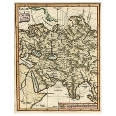
Antique Map of Asia with Northern Portion of Australia “Hollandia Nova", 1727
About the Item
Antique map titled 'Exactissima Asiae Delineatio in praecipuas regiones Caeterasq Partes.' Original antique map of the continent of Asia with a northern portion of Australia “Hollandia Nova”. The map is embellished by a vivacious scene of native Asian figures and a camel, parrots and a monkey as part of the title cartouche. Published in Amsterdam by R. & J. Ottens.
Artists and Engravers: Reinier and Joshua Ottens (both 1704-1765) are publishers, cartographers and map engravers from the Netherlands. The family business was founded by their father Joachim, but most productive during the time of Reiner and Joshua.
Condition: Good, given age. Small rusty hole in right margin. A small spot in the lower left margin. A few spots, mainly in the margins. Original middle fold as issued. General age-related toning and/or occasional minor defects from handling. Please study image carefully.
Date: c.1727
Overall size: 63.5 x 53.5 cm.
Image size: 47.3 x 49.2 cm.
We sell original antique maps to collectors, historians, educators and interior decorators all over the world. Our collection includes a wide range of authentic antique maps from the 16th to the 20th centuries. Buying and collecting antique maps is a tradition that goes back hundreds of years. Antique maps have proved a richly rewarding investment over the past decade, thanks to a growing appreciation of their unique historical appeal. Today the decorative qualities of antique maps are widely recognized by interior designers who appreciate their beauty and design flexibility. Depending on the individual map, presentation, and context, a rare or antique map can be modern, traditional, abstract, figurative, serious or whimsical. We offer a wide range of authentic antique maps for any budget.
- Dimensions:Height: 21.07 in (53.5 cm)Width: 25.01 in (63.5 cm)Depth: 0 in (0.01 mm)
- Materials and Techniques:
- Period:
- Date of Manufacture:circa 1727
- Condition:
- Seller Location:Langweer, NL
- Reference Number:
About the Seller
5.0
Platinum Seller
These expertly vetted sellers are 1stDibs' most experienced sellers and are rated highest by our customers.
Established in 2009
1stDibs seller since 2017
1,916 sales on 1stDibs
Typical response time: <1 hour
- ShippingRetrieving quote...Ships From: Langweer, Netherlands
- Return PolicyA return for this item may be initiated within 14 days of delivery.
More From This SellerView All
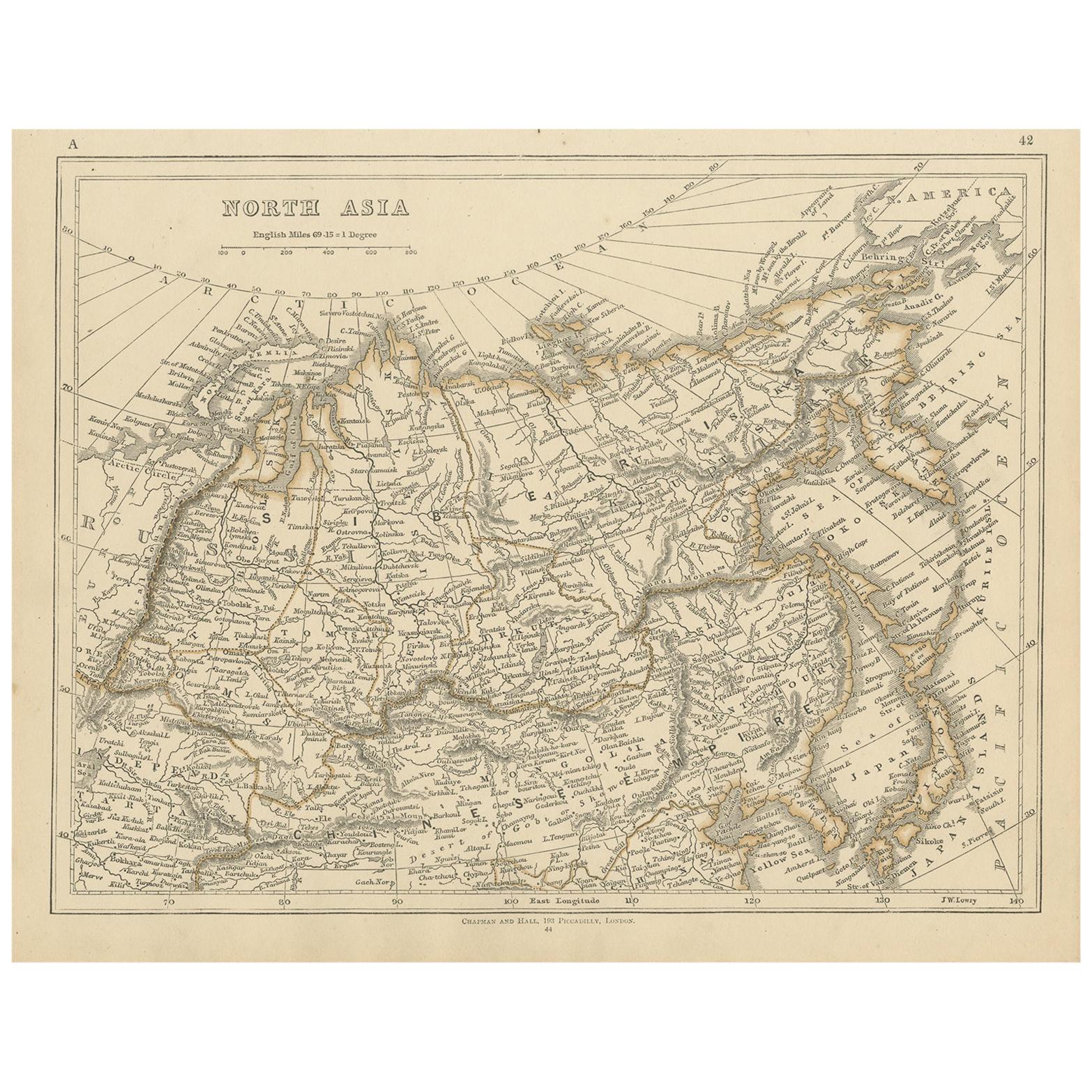
- Antique Map of Northern Asia by Lowry, 1852Located in Langweer, NLAntique map titled 'North Asia'. Original map of Northern Asia. This map originates from 'Lowry's Table Atlas constructed and engraved from the most recent authorities' by J.W. Lowry...Category
Antique Mid-19th Century Maps
MaterialsPaper
- Antique Map of the Northern Portion of the Philippines by J.N. Bellin, 1764Located in Langweer, NLDetailed map of the Northern portion of the Philippines, extending from Batanes and Babuyanes to Mindonoro and Masbate, and centered on Luzon. One of the most detailed maps of the pe...Category
Antique Mid-18th Century Maps
MaterialsPaper
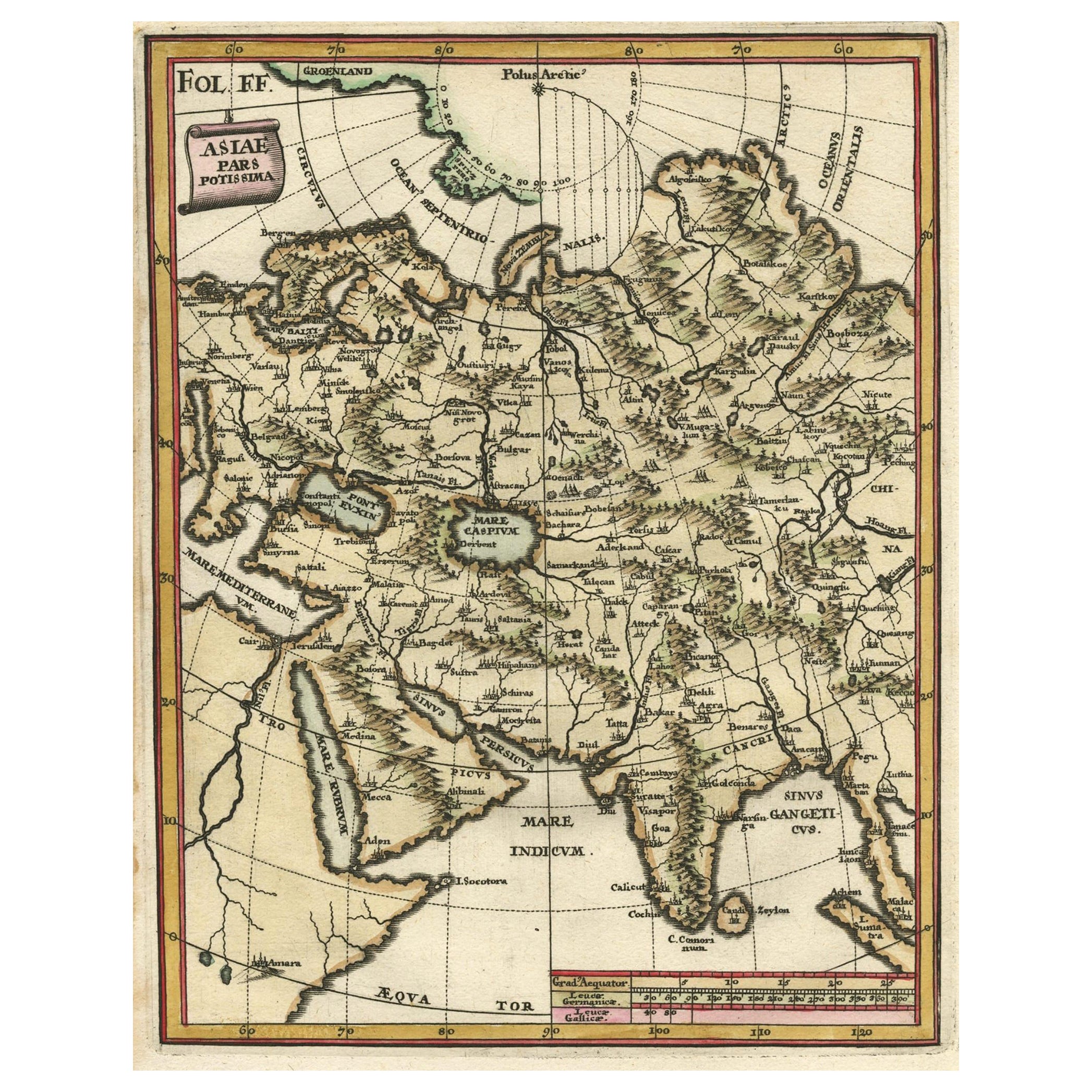
- Antique Map of Central Asia Wiht Nova Zembla as an Island, C.1700Located in Langweer, NLAntique map titled 'Asiae Pars Potissima.' Attractive map focusing on the central part of Asia but extending to include much of Eastern Europe and Northeastern Africa. The Caspian Se...Category
Antique 18th Century Maps
MaterialsPaper
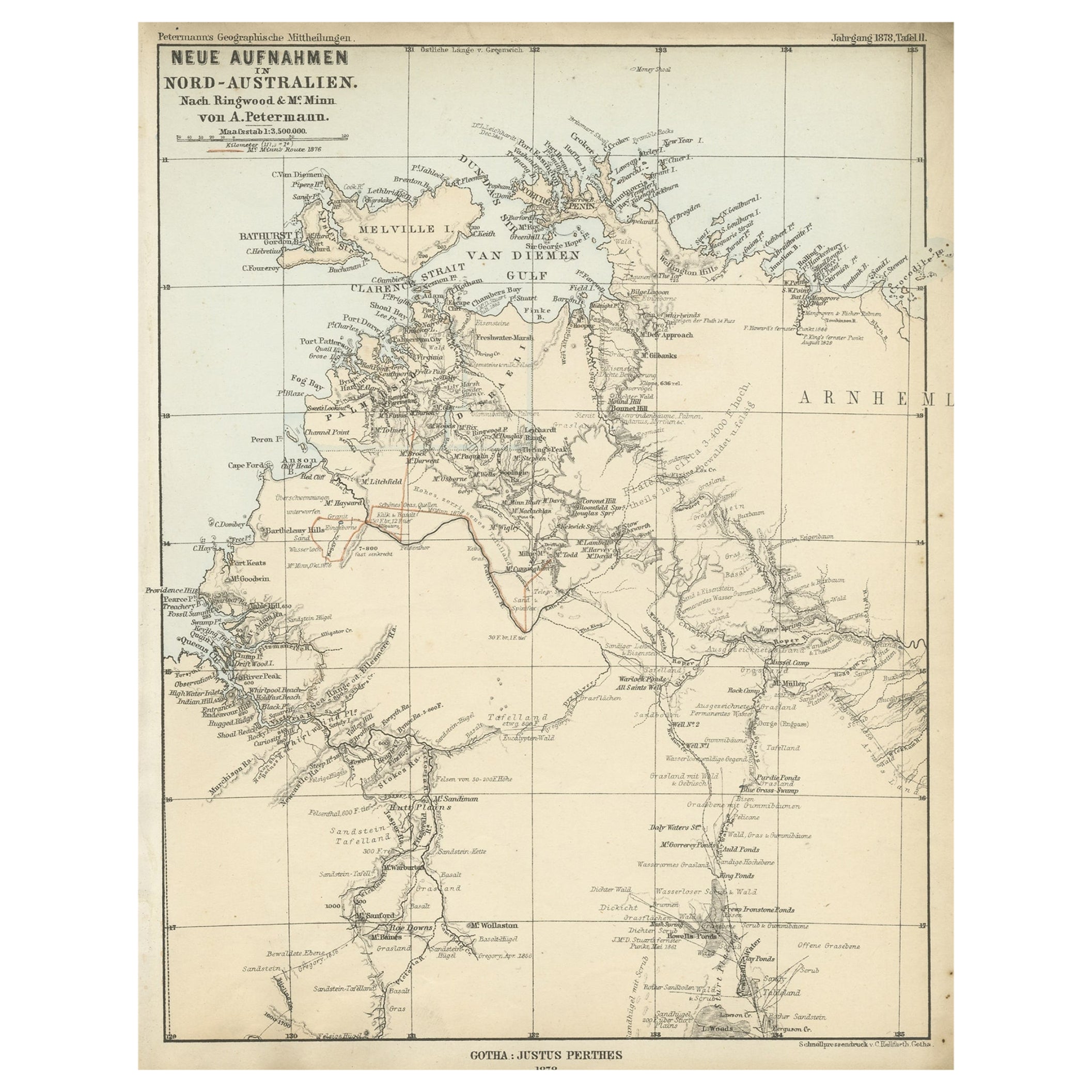
- Northern Australia Map with The Routes of Explorers Ringwood and McMinn, 1878Located in Langweer, NLAntique map titled 'Neue Aufnahmen in Nord-Australien'. Old map of Northern Australia showing the 'new routes' of the exploration of Ringwood and McMinn. Covers as far east as pa...Category
Antique 1870s Maps
MaterialsPaper
- Original Antique Map of Northern IndiaBy Jakob van der SchleyLocated in Langweer, NLAntique map titled 'Carte de l'Indoustan (..) - Kaart van Hindoestan (..)'. Original antique map of northern India. This map originates from 'His...Category
Antique Mid-18th Century Maps
MaterialsPaper
- Antique Map of Asia by with an Inset Map of Turkey in Asia, 1868Located in Langweer, NLAntique map Asia titled 'Carte Politique et Ethnographique d'Asie'. Old map of Asia with an inset map of Turkey in Asia. Includes descriptive text box...Category
Antique 19th Century Maps
MaterialsPaper


You May Also Like
- Original Antique Map of South East Asia, Arrowsmith, 1820Located in St Annes, LancashireGreat map of South East Asia Drawn under the direction of Arrowsmith Copper-plate engraving Published by Longman, Hurst, Rees, Orme and Brown, 1820 Unframed.Category
Antique 1820s English Maps
MaterialsPaper
- Sweden & Adjacent Portions of Scandinavia: A Hand-Colored 18th C. Map by HomannBy Johann Baptist HomannLocated in Alamo, CAThis hand-colored map of Sweden and adjacent portions of Scandinavia entitled "Regni Sueciae in Omnes suas Subjacentes Provincias accurate divisi Tabula Generalis" was created by Joh...Category
Antique 1720s German Maps
MaterialsPaper
- Scandinavia & Portions of Eastern Europe: 18th Century Hand-Colored Homann MapBy Johann Baptist HomannLocated in Alamo, CAAn early 18th century hand-colored copper-plate map entitled "Regni Sueciae in omnes suas Subjacentes Provincias accurate divisi Tabula Generalis" by Johann Baptist Homann (1663-1724...Category
Antique Early 18th Century German Maps
MaterialsPaper
- Original Antique Map of South East Asia by Thomas Clerk, 1817Located in St Annes, LancashireGreat map of South East Asia Copper-plate engraving Drawn and engraved by Thomas Clerk, Edinburgh. Published by Mackenzie And Dent, 1817 Unframed.Category
Antique 1810s English Maps
MaterialsPaper
- Original Antique Map of South East Asia by Becker, circa 1840Located in St Annes, LancashireGreat map of South East Asia Steel engraving with original color outline Engraved by Becker Published by Virtue, circa 1840. Unframed.Category
Antique 1840s English Other Maps
MaterialsPaper
- Antique Map of Principality of MonacoBy Antonio Vallardi EditoreLocated in Alessandria, PiemonteST/619 - "Old Geographical Atlas of Italy - Topographic map of ex-Principality of Monaco" - ediz Vallardi - Milano - A somewhat special edition ---Category
Antique Late 19th Century Italian Other Prints
MaterialsPaper


Recently Viewed
View AllMore Ways To Browse
Australian Designer Furniture
Australian Antiques
Australian Antique Furniture
Antique Furniture In Australia
Australia Antique Furniture
Map Australia
Maps Of Australia
Rusty Antique
Antique Collectables Australia
18th Century Parrot
Parrot 18th
Antique Maps Australia
Antique Map Australia
Australia Antique Map
Antique Maps Of Australia
Antique Map Of Australia
Antique Australia Map
Antique Australian Map