Items Similar to Antique Map of China, 1874


Want more images or videos?
Request additional images or videos from the seller
1 of 5
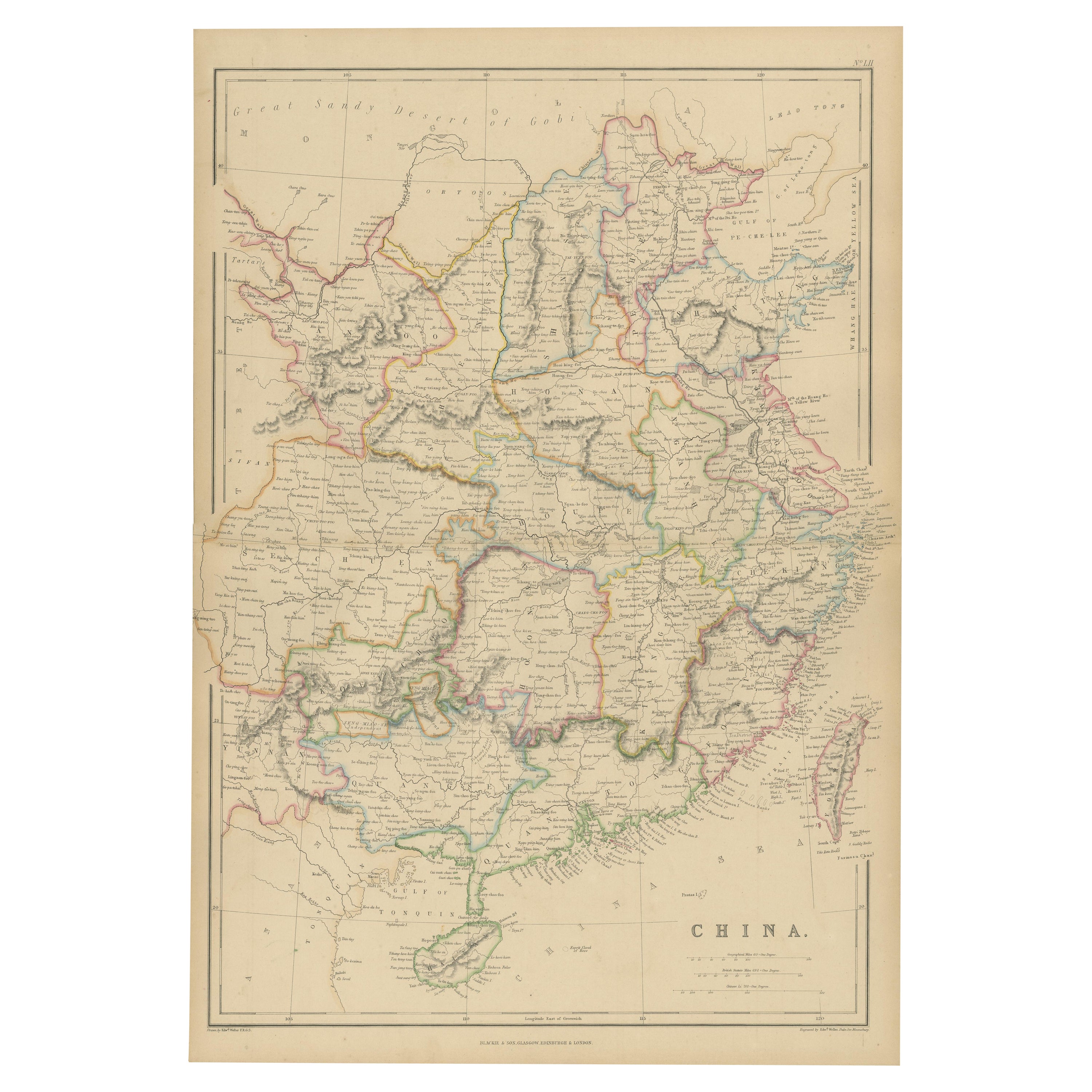
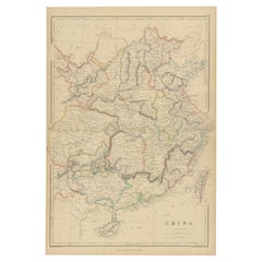
Antique Map of China, 1874
About the Item
Antique map titled 'China'. Detailed map of China originates from Blackie's 'The Comprehensive Atlas & Geography of the World'.
Artists and Engravers: Edward Weller, English cartographer of which little is known of his personal life although he produced a number of important maps and was elected a member of the Royal Geographical Society.
Condition: Good, general age-related toning. Few small tears and splits on folding line, please study image carefully.
Date: 1874
Overall size: 37.5 x 54 cm.
Image size: 34 x 50 cm.
We sell original antique maps to collectors, historians, educators and interior decorators all over the world. Our collection includes a wide range of authentic antique maps from the 16th to the 20th centuries. Buying and collecting antique maps is a tradition that goes back hundreds of years. Antique maps have proved a richly rewarding investment over the past decade, thanks to a growing appreciation of their unique historical appeal. Today the decorative qualities of antique maps are widely recognized by interior designers who appreciate their beauty and design flexibility. Depending on the individual map, presentation, and context, a rare or antique map can be modern, traditional, abstract, figurative, serious or whimsical. We offer a wide range of authentic antique maps for any budget.
- Dimensions:Height: 21.26 in (54 cm)Width: 14.77 in (37.5 cm)Depth: 0 in (0.01 mm)
- Materials and Techniques:
- Period:
- Date of Manufacture:1874
- Condition:
- Seller Location:Langweer, NL
- Reference Number:
About the Seller
5.0
Platinum Seller
These expertly vetted sellers are 1stDibs' most experienced sellers and are rated highest by our customers.
Established in 2009
1stDibs seller since 2017
1,933 sales on 1stDibs
Typical response time: <1 hour
- ShippingRetrieving quote...Ships From: Langweer, Netherlands
- Return PolicyA return for this item may be initiated within 14 days of delivery.
More From This SellerView All
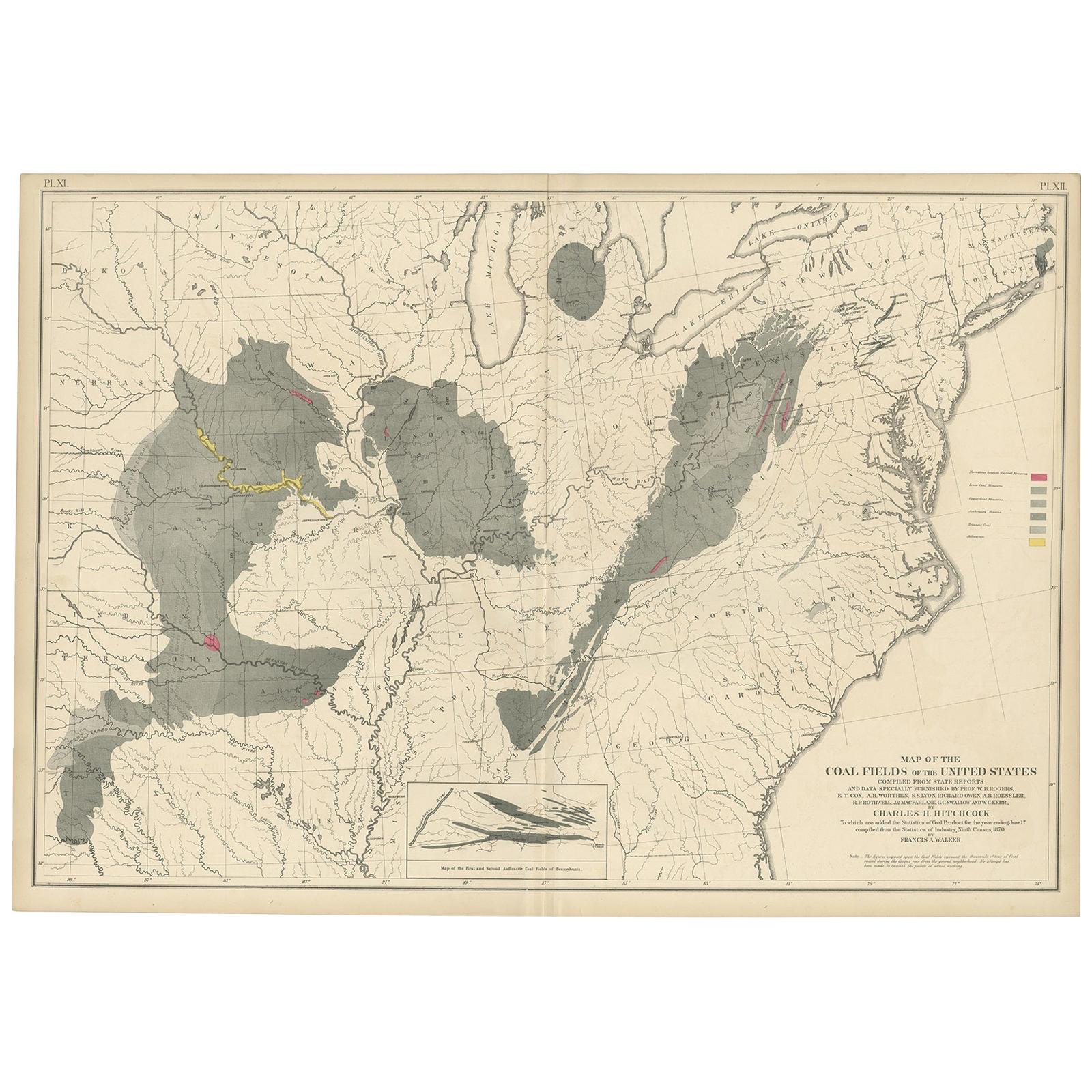
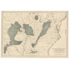
- Antique Map of the Coal Fields of the United States by Walker '1874'Located in Langweer, NLAntique map titled 'Map of the coal fields of the United States, compiled from state reports and data specially furnished by Prof. W.B. Rogers, E.T. Cox, A.H. Worthen, S.S. Lyon, Ric...Category
Antique Late 19th Century Maps
MaterialsPaper
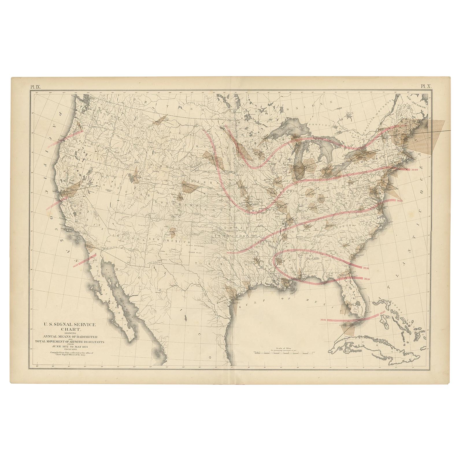
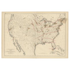
- Pl. 9 Antique Map of the Air Movement of the United States by Walker '1874'Located in Langweer, NLAntique map titled 'U.S. Signal Service chart, showing annual means of barometer and total movement of air with resultants from June 1872 to May 1873 inclusive. Compiled from data co...Category
Antique Late 19th Century Maps
MaterialsPaper
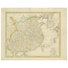
- Antique Map of China by W. G. Blackie, 1859Located in Langweer, NLAntique map titled 'China'. Original antique map of China. This map originates from ‘The Imperial Atlas of Modern Geography’. Published by W. G. Blackie, 1859.Category
Antique Mid-19th Century Maps
MaterialsPaper
- Antique Map of China by A & C, Black, 1870Located in Langweer, NLAntique map titled 'China'. Original antique map of China. This map originates from ‘Black's General Atlas of The World’. Published by A & C. Black, 1870.Category
Antique Late 19th Century Maps
MaterialsPaper
- Antique Map of China by Wilkinson '1803'Located in Langweer, NLAntique map titled 'China, Contains 15 Subject Provinces Including the 2 Islands of Hainan, Formosa and the Tributary Kingdoms of Korea, Tonkin'. Old map depicting China, extending f...Category
Antique Early 19th Century Maps
MaterialsPaper
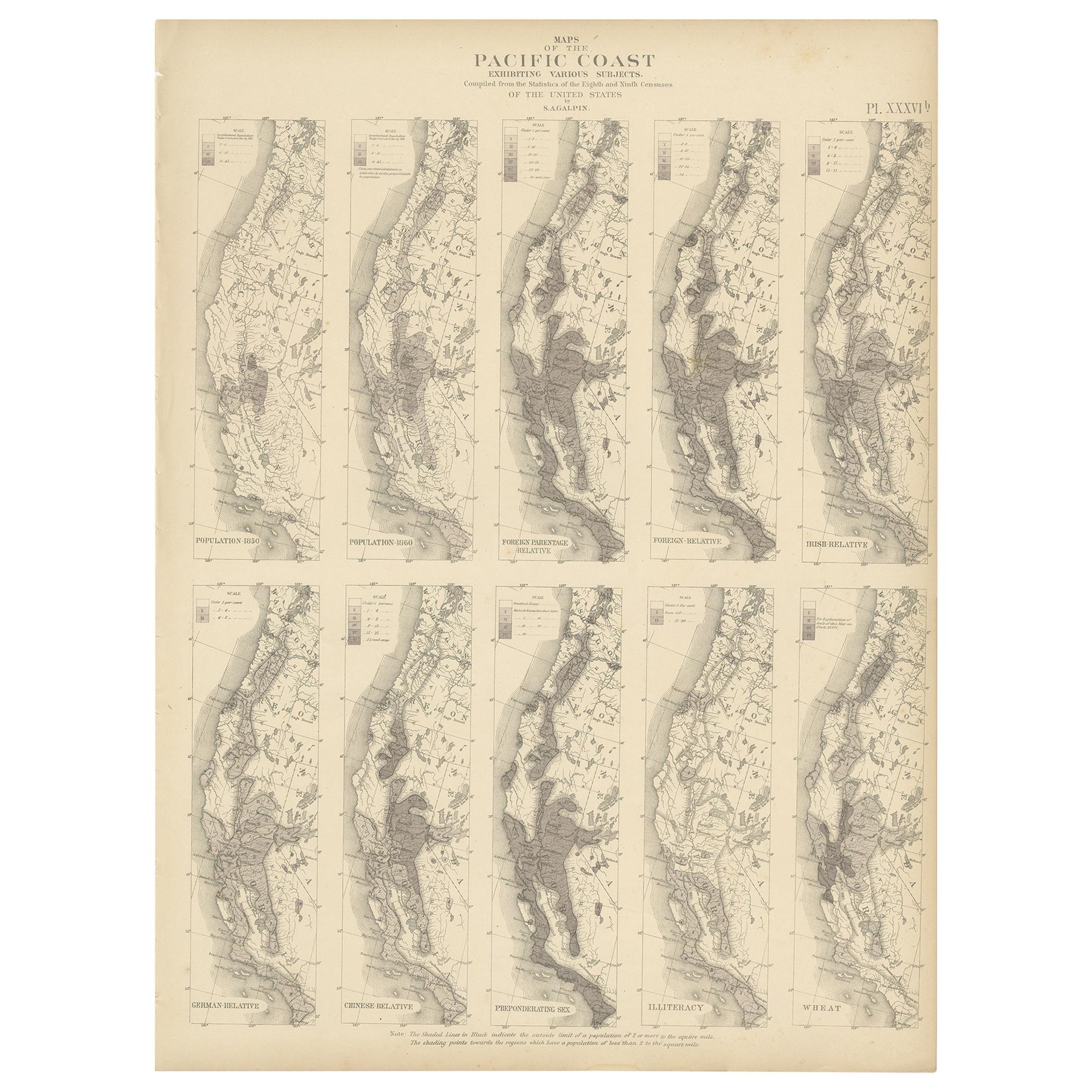
- Antique Chart of the Pacific Coast '1874'Located in Langweer, NLAntique chart titled 'Maps of the Pacific Coast exhibiting various subjects. Compiled from the statistics of the eight and ninth census of the United Sta...Category
Antique Late 19th Century Maps
MaterialsPaper


You May Also Like
- Original Antique Map of China by Thomas Clerk, 1817Located in St Annes, LancashireGreat map of China Copper-plate engraving Drawn and engraved by Thomas Clerk, Edinburgh. Published by Mackenzie And Dent, 1817 Unframed.Category
Antique 1810s English Maps
MaterialsPaper
- Antique Map of Principality of MonacoBy Antonio Vallardi EditoreLocated in Alessandria, PiemonteST/619 - "Old Geographical Atlas of Italy - Topographic map of ex-Principality of Monaco" - ediz Vallardi - Milano - A somewhat special edition ---Category
Antique Late 19th Century Italian Other Prints
MaterialsPaper
- Original Antique Map of Italy. C.1780Located in St Annes, LancashireGreat map of Italy Copper-plate engraving Published C.1780 Unframed.Category
Antique Early 1800s English Georgian Maps
MaterialsPaper

- Original Antique Map of Asia. C.1780Located in St Annes, LancashireGreat map of Asia Copper-plate engraving Published C.1780 Two small worm holes to right side of map Unframed.Category
Antique Early 1800s English Georgian Maps
MaterialsPaper

- Original Antique Map of India. C.1780Located in St Annes, LancashireGreat map of India Copper-plate engraving Published C.1780 Three small worm holes to right side of map and one bottom left corner Unframed.Category
Antique Early 1800s English Georgian Maps
MaterialsPaper

- Original Antique Map of Canada, Arrowsmith, 1820Located in St Annes, LancashireGreat map of Canada. Drawn under the direction of Arrowsmith. Copper-plate engraving. Published by Longman, Hurst, Rees, Orme and Brown, 1820 ...Category
Antique 1820s English Maps
MaterialsPaper


Recently Viewed
View AllMore Ways To Browse
Collecting Antique China
Collectible Antique China
Chinese Antique Collectables
Chinese General
16th Century English Antique
Chinese Map
Chinese Maps
China Map
Map Of China
Antique English Maps
Chinese Hundred Antiques
Antique Chinese 16th
16th Century Chinese Antiques
Antique Map China
Antique China Map
Antique Chinese Maps
Antique Maps Of China
Antique Map Of China