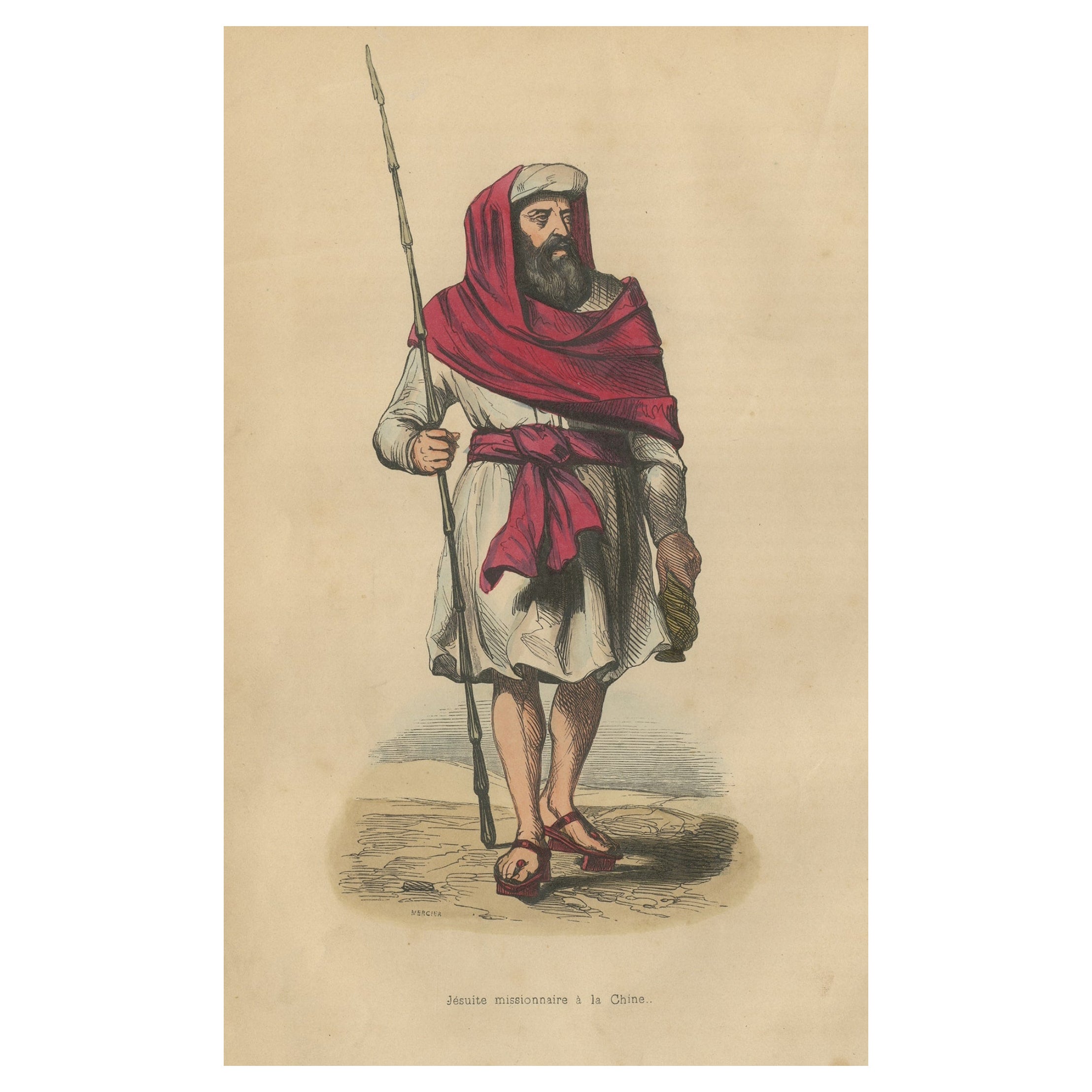
Journal of a Voyage to Madras and India in 1812-1813 with 24 Hand Colored Prints
View Similar Items
Want more images or videos?
Request additional images or videos from the seller
1 of 19
Journal of a Voyage to Madras and India in 1812-1813 with 24 Hand Colored Prints
About the Item
- Dimensions:Height: 11 in (27.94 cm)Width: 8 in (20.32 cm)Depth: 1 in (2.54 cm)
- Style:Regency (Of the Period)
- Materials and Techniques:
- Place of Origin:
- Period:
- Date of Manufacture:1814
- Condition:Wear consistent with age and use. Minor losses. There is foxing throughout the volume with more on the text and quite a bit less on the plates. Cover has some sun fading. Overall a very attractive book.
- Seller Location:San Francisco, CA
- Reference Number:Seller: C1021-111stDibs: LU855230600882
About the Seller
5.0
Recognized Seller
These prestigious sellers are industry leaders and represent the highest echelon for item quality and design.
Platinum Seller
Premium sellers with a 4.7+ rating and 24-hour response times
Established in 1982
1stDibs seller since 2008
353 sales on 1stDibs
Typical response time: 2 hours
Associations
The Art and Antique Dealers League of AmericaAntiques Associations Members
Authenticity Guarantee
In the unlikely event there’s an issue with an item’s authenticity, contact us within 1 year for a full refund. DetailsMoney-Back Guarantee
If your item is not as described, is damaged in transit, or does not arrive, contact us within 7 days for a full refund. Details24-Hour Cancellation
You have a 24-hour grace period in which to reconsider your purchase, with no questions asked.Vetted Professional Sellers
Our world-class sellers must adhere to strict standards for service and quality, maintaining the integrity of our listings.Price-Match Guarantee
If you find that a seller listed the same item for a lower price elsewhere, we’ll match it.Trusted Global Delivery
Our best-in-class carrier network provides specialized shipping options worldwide, including custom delivery.More From This Seller
View AllWorks of F. Crawford in 5 Volumes Bound in Blue Morocco Leather with Gilt Spines
Located in San Francisco, CA
The works of Victorian period American author F. Marion Crawford (1854-1909) an erudite novelist born in Italy, the son of a sculptor. The set includes some of his better known works...
Category
Antique Late 19th Century American Books
Materials
Leather, Paper
The Poetic and Dramatic Works of Robert Browning Bound in Leather and Cloth
Located in San Francisco, CA
An attractive leather bound set of the poetic and dramatic works of Robert Browning (1812-1889) published in 1906 by Houghton Mifflin and Company, New York and Boston. Top edges gilt...
Category
Early 20th Century American Books
Materials
Leather, Paper
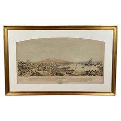
Early San Francisco View by Henry Firks Printed by W.H. Jones in 1849
Located in San Francisco, CA
A tinted lithographic view of San Francisco, made during the gold rush, showing a panoramic view of the bay's waterfront from the south along Montgomery Street to Telegraph Hill. The...
Category
Antique Mid-19th Century American Victorian Maps
Materials
Paper
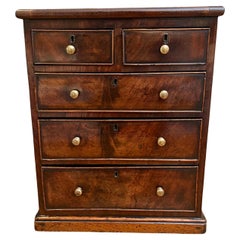
English Regency Style Mahogany Miniature 5 Drawer Chest with Brass Knobs
Located in San Francisco, CA
A good quality English mahogany miniature chest with 2 short over 3 long drawers, each retaining their original brass knobs, supported on a plinth base. Very attractive color and fi...
Category
Antique Mid-19th Century English Regency Models and Miniatures
Materials
Brass
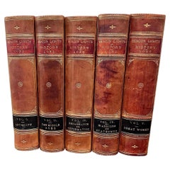
Beacon Lights of History by John Lord in 5 volumes
Located in San Francisco, CA
A five volume leather bound set titled "Beacon Lights of History" by John Lord
published in New York in 1884 by Fords, Howard and Hulbert profiling various historical luminaries from...
Category
Antique 1880s American Books
Materials
Leather, Paper
Extraordinary and Unique Model of a Japanese Tea House
Located in San Francisco, CA
A wonderful Japanese model of a traditional tea house, each room with latticework sliding doors, tatami mats and miniature decorations hanging on the walls,...
Category
Antique 19th Century Japanese Architectural Models
Materials
Straw, Wood, Paper

You May Also Like
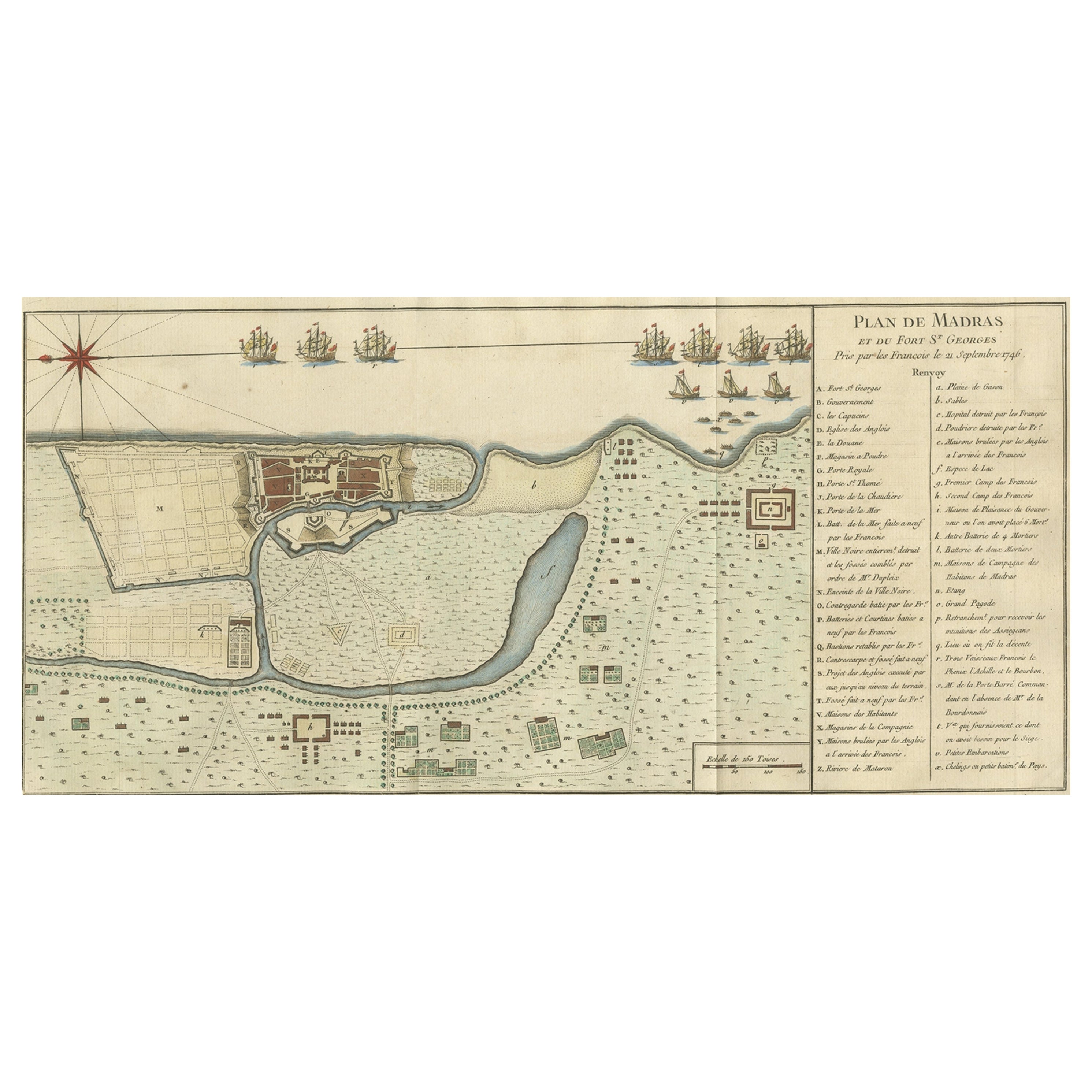
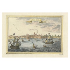
Antique Colored Engraving of Madras 'Chennai' and Fort St. George in India, 1751
By Jacques-Nicolas Bellin
Located in Langweer, NL
Antique print titled 'Plan de Madras et du Fort St. Georges'. Plan of the city of Madras (or Chennai), the capital of the state of Tamil Nadu, India. Also shows a plan of Fort St. Ge...
Category
Antique 18th Century Prints
Materials
Paper
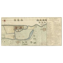
$333 Sale Price
20% Off
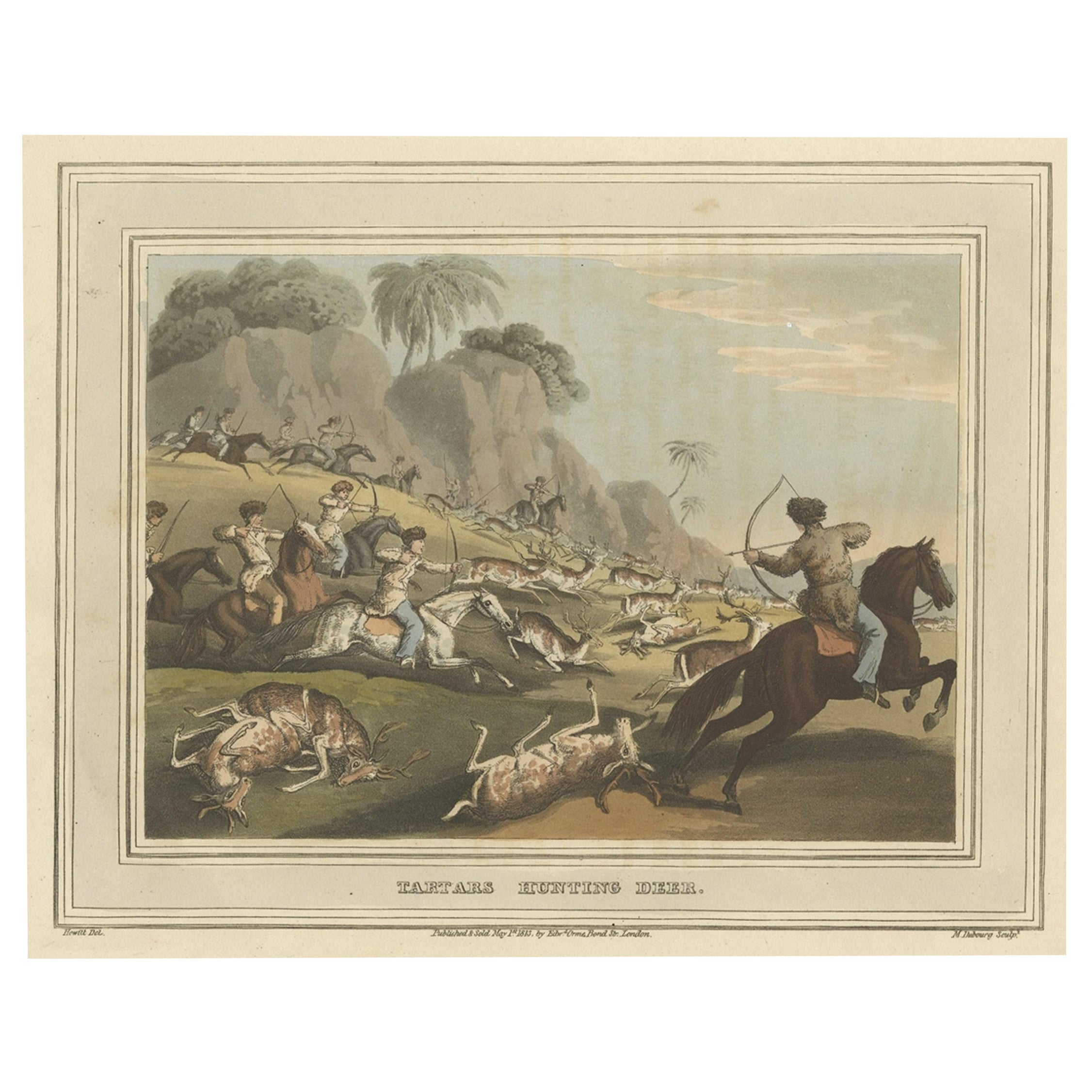
Decorative Hand-Colored Antique Print of Tartars Hunting Deer in Russia, 1813
Located in Langweer, NL
Antique print titled 'Tartars hunting deer'. This print originates from Samuel Howitt's 'Foreign Field Sports'.
Artists and Engravers: Samuel Howitt was an English painter, illust...
Category
Antique 1810s Prints
Materials
Paper
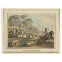
$240 Sale Price
20% Off
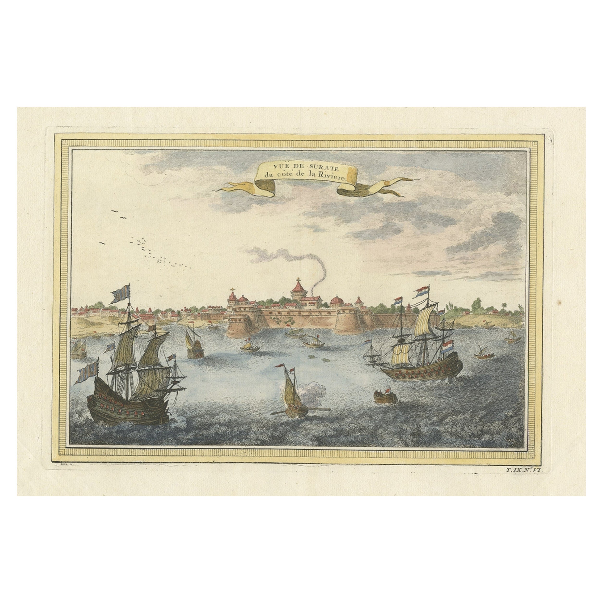
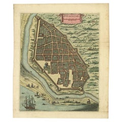
Nicely Colored Antique Print of Surat in India, 1751
Located in Langweer, NL
Antique print titled 'Vuë de Surate du côté de la Riviere'. View of Surat, a city in the state of Gujarat, India. This print originates from 'Histoire générale des voyages' by A. Pré...
Category
Antique 18th Century Prints
Materials
Paper
$333 Sale Price
20% Off
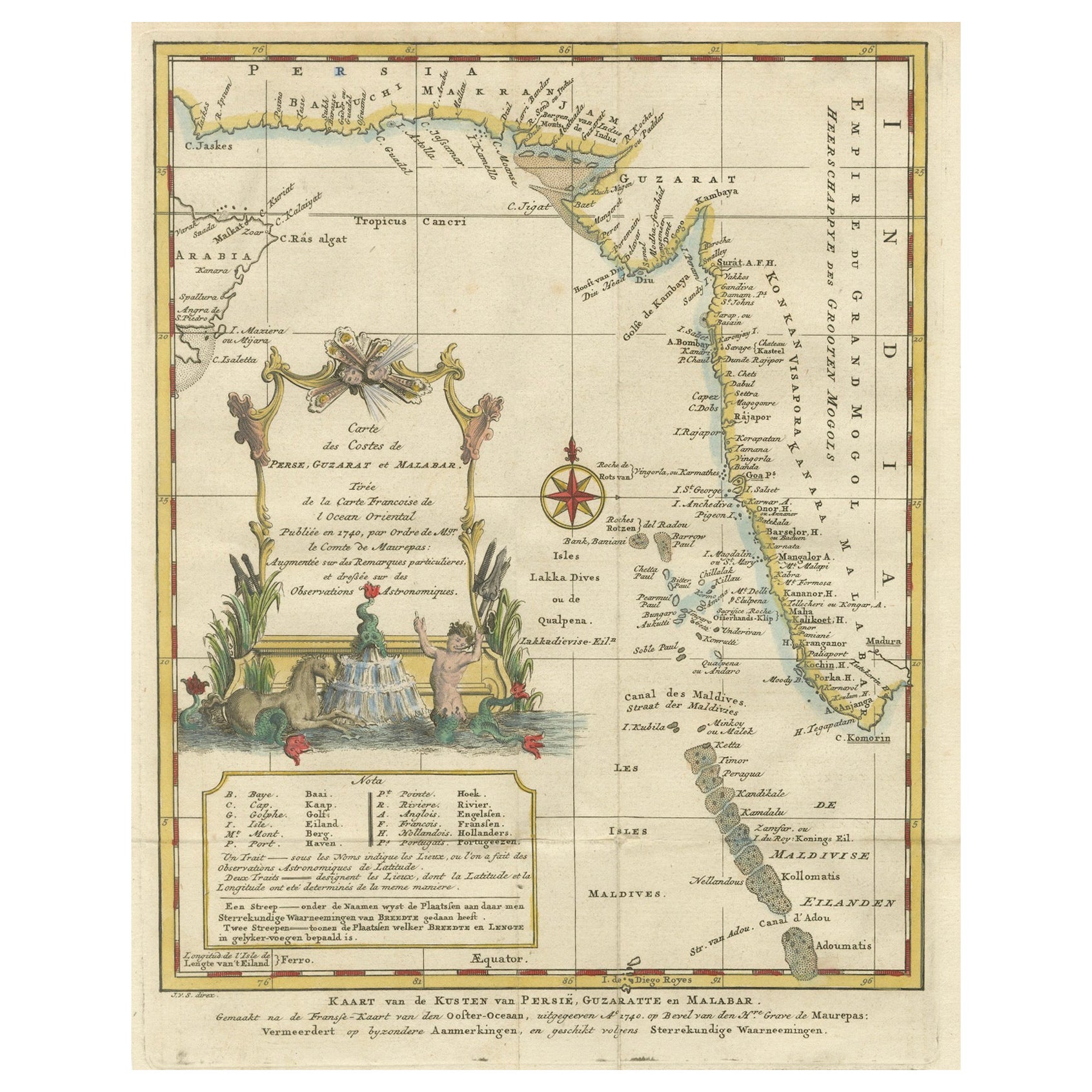
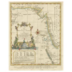
1773 Map of Persia, Gujarat & Malabar Coasts – Arabia to India, Hand-Colored
Located in Langweer, NL
1773 Bellin map of Persia, Gujarat and Malabar coasts with Arabia and Maldives
Description:
This finely engraved and delicately hand-colored 18th-century map titled Kaart van de Kusten van Persië, Guzaratte en Malabar was produced by the eminent French cartographer Jacques-Nicolas Bellin and engraved by Jakob van der Schley. It was published in 1773 in Amsterdam by E. van Harrevelt and D. Changuion, as part of a Dutch edition of Bellin’s maritime atlas focused on the East Indies and the Indian Ocean.
The map presents the coastline bordering the Arabian Sea, extending from the Persian Gulf and parts of the Arabian Peninsula to the shores of Gujarat and the Malabar Coast in southwestern India. It provides a detailed representation of the coastlines of Persia (modern-day Iran), the western coast of India, and a portion of southern Arabia including the Oman Peninsula. Coastal towns, rivers, ports, and geographical landmarks are clearly labeled, including prominent trading centers like Surat, Goa, Calicut, Cochin, and Cape Comorin (now Kanyakumari).
Additionally, the map shows the Laccadive Islands (Laka Dives) and the Maldives (Maldivische Eilanden), with attention to navigational details such as shoals, sandbanks, and anchor points. A large compass rose and clear latitude and longitude markings enhance its utility as a navigational aid.
A highly decorative title cartouche at lower left features maritime iconography such as sea creatures, a fountain, and shells. An inset legend beneath the map provides explanations in Dutch for the symbols used to indicate bays, capes, ports, forts, islands, and towns.
This is a copperplate engraving printed on laid paper with full original hand coloring. It retains its original fold lines as issued. The condition is generally good, with minor age toning and a few light spots in the margins. No repairs or restoration are visible. The paper is strong, and the impression remains crisp and clear.
This historical map is a significant and attractive example of 18th-century European cartography, especially valued for its depiction of maritime trade regions and coastal geography during the age of exploration and colonial expansion.
To frame this 1773 Bellin map attractively and safely:
- Use acid-free matting in a neutral tone like cream or antique white
- Consider double matting with a subtle inner color that complements the map
- Choose a simple wooden frame in walnut, cherry, or aged oak for a classic look
- Use UV-protective glass or acrylic to prevent fading
- For a full display, consider float mounting to show the edges and fold lines
- Allow 2 to 3 inch mat margins to balance the composition and enhance presentation
Keywords:
Bellin map 1773, van der Schley, Persia coast map, Gujarat map, Malabar map...
Category
Antique 1780s Maps
Materials
Paper
$314 Sale Price
20% Off
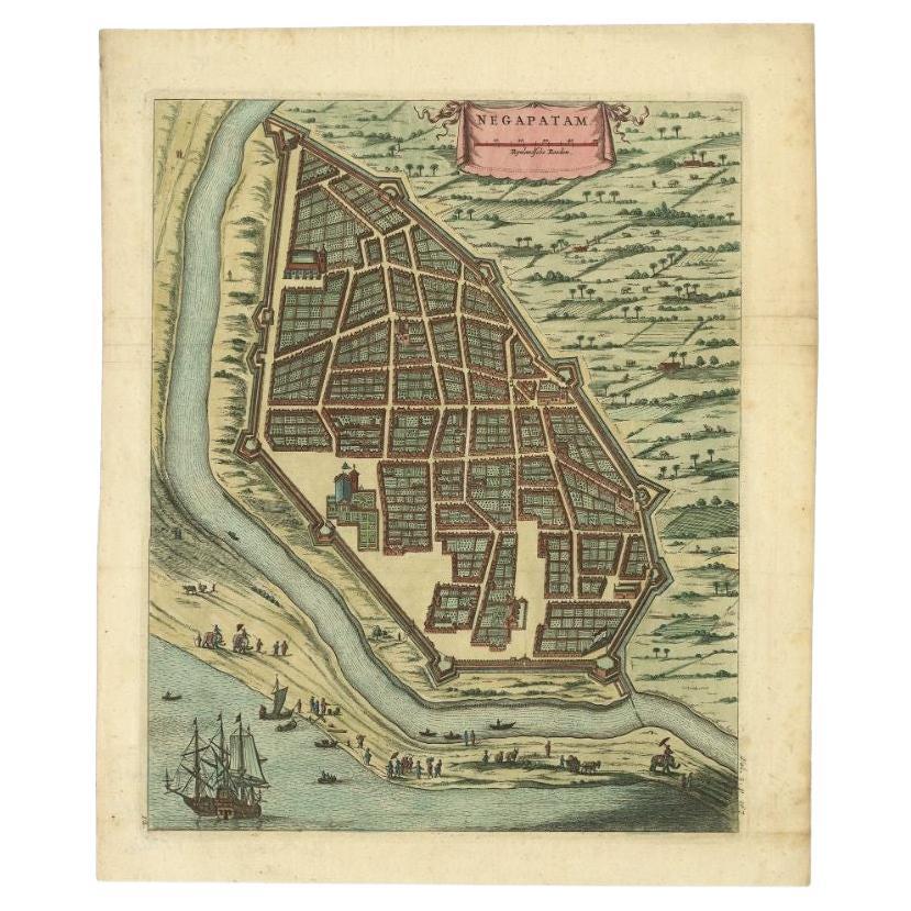
Attractive Hand-Colored Antique Plan of Nagapattinam in India, 1744
Located in Langweer, NL
Antique map titled 'Negapatam.' Attractive bird's-eye view of Nagapattinam, India from Churchill's 'A Collection of Voyages and Travels, some now first printed from original manuscri...
Category
Antique 18th Century Maps
Materials
Paper
$512 Sale Price
25% Off
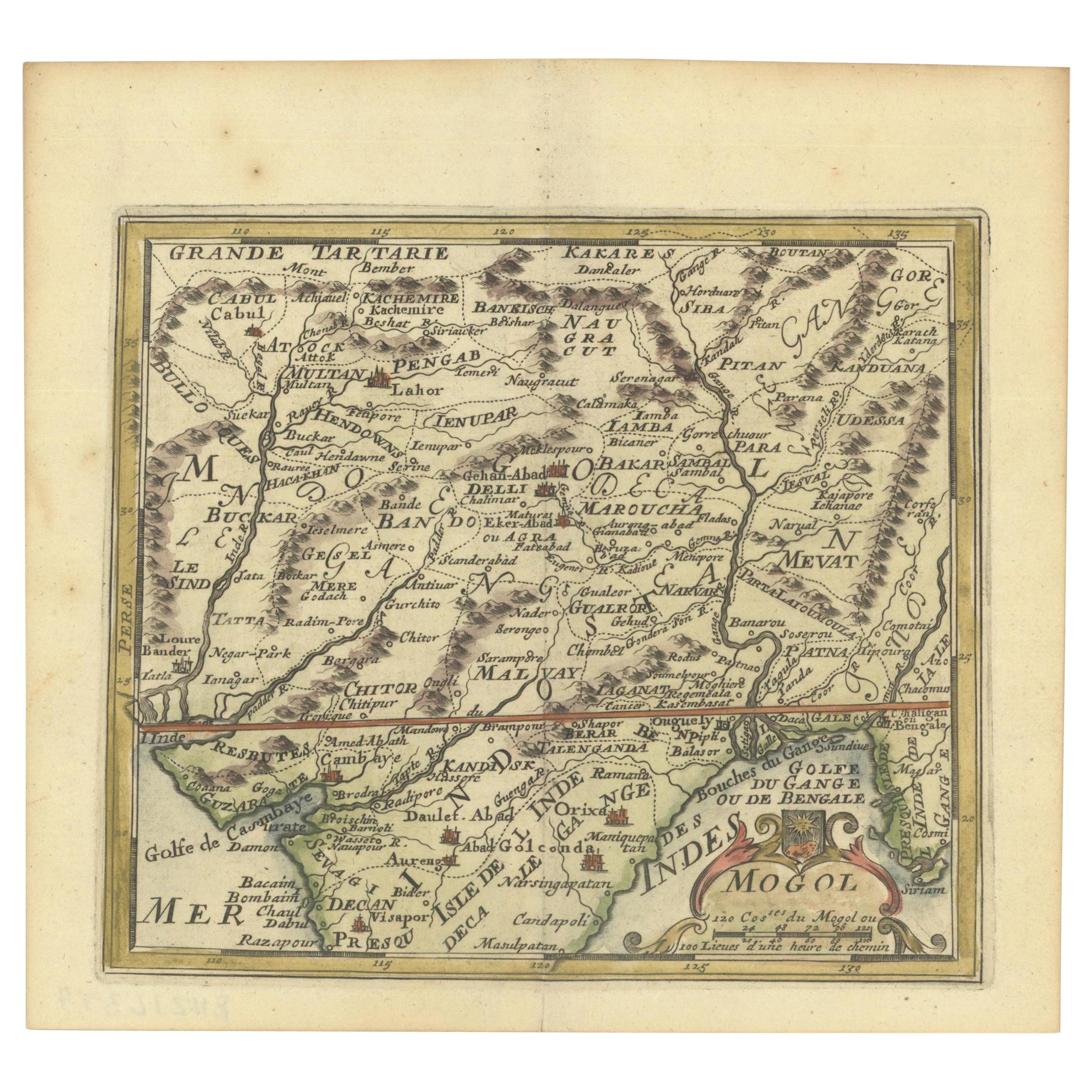
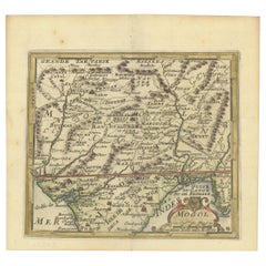
1692 Engraved Map: Detailed Mogul Empire, India to Afghanistan, Hand-Colored
Located in Langweer, NL
1692 Map of the Mogul Empire by Jacques Peeters
This finely engraved map, published in 1692 by Jacques Peeters, showcases the Mogul Empire region, covering areas from northern India...
Category
Antique 1690s Maps
Materials
Paper
$453 Sale Price
20% Off