Want more images or videos?
Request additional images or videos from the seller
1 of 5
1861 Topographical Map of the District of Columbia, by Boschke, Antique Map
$40,000List Price
About the Item
- Dimensions:Height: 53.25 in (135.26 cm)Width: 53.75 in (136.53 cm)Depth: 3.5 in (8.89 cm)
- Materials and Techniques:
- Place of Origin:
- Period:
- Date of Manufacture:1861
- Condition:Wear consistent with age and use. Overall very good condition considering age. Significant crease in center where sheets are joined, scattered holes and light staining, but overall a very stabile and clear example. Framed according to the highest conservation standards.
- Seller Location:Colorado Springs, CO
- Reference Number:Seller: M280-C1stDibs: LU909716545792
About the Seller
4.9
Vetted Professional Seller
Every seller passes strict standards for authenticity and reliability
Established in 2010
1stDibs seller since 2011
465 sales on 1stDibs
Authenticity Guarantee
In the unlikely event there’s an issue with an item’s authenticity, contact us within 1 year for a full refund. DetailsMoney-Back Guarantee
If your item is not as described, is damaged in transit, or does not arrive, contact us within 7 days for a full refund. Details24-Hour Cancellation
You have a 24-hour grace period in which to reconsider your purchase, with no questions asked.Vetted Professional Sellers
Our world-class sellers must adhere to strict standards for service and quality, maintaining the integrity of our listings.Price-Match Guarantee
If you find that a seller listed the same item for a lower price elsewhere, we’ll match it.Trusted Global Delivery
Our best-in-class carrier network provides specialized shipping options worldwide, including custom delivery.You May Also Like
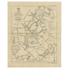
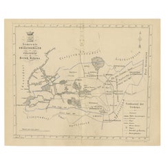
Antique Map of the Menaldumadeel Township by Behrns, 1861
Located in Langweer, NL
Antique map titled 'Gemeente Menaldumadeel'. Old map depicting the Menaldumadeel township including cities and villages like Berlikum, Wier, Menaldum, Dronrijp, Marsum, Engelum, Dein...
Category
Antique 19th Century Maps
Materials
Paper
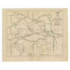
$85 Sale Price
20% Off
H 6.74 in W 8.31 in D 0 in
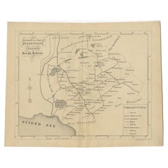
Antique Map of the Ferwerderadeel Township by Behrns, 1861
Located in Langweer, NL
Antique map titled 'Ferwerderadeel'. Old map depicting the Ferwerderadeel township including cities and villages like Ferwerd, Marrum, Hallum, Wanswerd and Hijum. This map orginates ...
Category
Antique 19th Century Maps
Materials
Paper
$85 Sale Price
20% Off
H 6.78 in W 8.23 in D 0 in
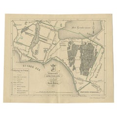
Antique Map of the Leeuwarderadeel Township by Behrns, 1861
Located in Langweer, NL
Antique map titled 'Gemeente Leeuwarderadeel'. Old map depicting the Leeuwarderadeel township including cities and villages like Finkum, Hijum, Stiens, Jelsum, Leeuwarden, Wirdum and...
Category
Antique 19th Century Maps
Materials
Paper

$85 Sale Price
20% Off
H 8.43 in W 6.78 in D 0 in
Antique Map of the Lemsterland Township by Behrns, 1861
Located in Langweer, NL
Antique map titled 'Gemeente Lemsterland'. Old map depicting the Lemsterland township including cities and villages like Lemmer, Follega, Oosterzee en Echten. This map orginates from...
Category
Antique 19th Century Maps
Materials
Paper
$85 Sale Price
20% Off
H 6.78 in W 8.15 in D 0 in
Antique Map of the Hennaarderadeel Township by Behrns, 1861
Located in Langweer, NL
Antique map titled 'Gemeente Hennaarderadeel'. Old map depicting the Hennaarderadeel township including cities and villages like Kubaard, Wommels, Hennaard, Oosterend, Wierum, Tzum, ...
Category
Antique 19th Century Maps
Materials
Paper
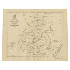
$85 Sale Price
20% Off
H 28.04 in W 8.35 in D 0 in
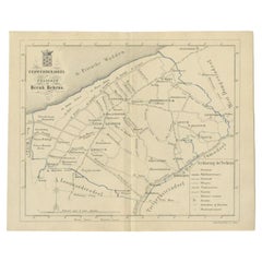
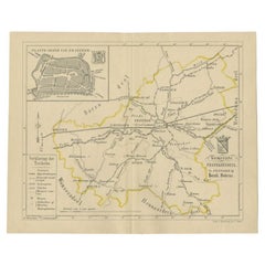
Antique Map of the Doniawerstal Township by Behrns, 1861
Located in Langweer, NL
Antique map titled 'Gemeente Doniawerstal'. Old map depicting the Doniawerstal township including cities and villages like Follega, Tjerkgaast, Legemeer, Idskenhuizen, St. Nicolaasga...
Category
Antique 19th Century Maps
Materials
Paper
$120 Sale Price
20% Off
H 8.27 in W 6.78 in D 0 in
Antique Map of the Franekeradeel Township by Behrns, 1861
Located in Langweer, NL
Antique map titled 'Gemeente Franekeradeel'. Old map depicting the Franekeradeel township including cities and villages like Franeker, Midlum, Hitsum, Schalsum, Dongjum, Peins and Ac...
Category
Antique 19th Century Maps
Materials
Paper
$85 Sale Price
20% Off
H 6.78 in W 8.27 in D 0 in
Antique Map of the Kollumerland Township by Behrns, 1861
Located in Langweer, NL
Antique map titled 'Gemeente Kollumerland en Nieuw Kruisland'. Old map depicting the Kollumerland township including cities and villages like Westergeest, Kollum, Kollumerzwaag and B...
Category
Antique 19th Century Maps
Materials
Paper
$85 Sale Price
20% Off
H 6.78 in W 8.31 in D 0 in
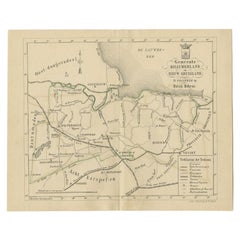
Antique Map of The Region of Heerenveen by Behrns, 1861
Located in Langweer, NL
Antique map titled 'Arrondissement Heerenveen'. Old map depicting the region of Heerenveen including cities and villages like Akkrum, Oudehaske, Wolvega, Donkerbroek and more. This m...
Category
Antique 19th Century Maps
Materials
Paper
$125 Sale Price
20% Off
H 6.78 in W 8.23 in D 0 in
Antique Map of The Dutch Smallingerland Township, 1861
Located in Langweer, NL
Antique map titled 'Gemeente Smallingerland'. Old map depicting the Smallingerland township including cities and villages like Eernewoude, Oudega, Boornbergum, Opeinde and Drachten. ...
Category
Antique 19th Century Maps
Materials
Paper
$96 Sale Price
20% Off
H 6.78 in W 8.19 in D 0 in
More From This Seller
View All1904 "Nell's Topographical Map of the State of Colorado"
Located in Colorado Springs, CO
This highly detailed pocket map is a topographical map of the state of Colorado by Louis Nell from 1904. The map "has been compiled from all available...
Category
Antique Early 1900s American Maps
Materials
Leather, Paper

1868 "Lloyd's Topographical Railway Map of North America..." Hanging Wall Map
Located in Colorado Springs, CO
Presented is “Lloyd's Topographical Railway Map of North-America, or the United States Continent in 1900.” This map was published by J. T. Lloyd, in New York, in 1868. A large, hangi...
Category
Antique 1860s American Late Victorian Maps
Materials
Linen, Paper

1812 United States Map, by Pierre Tardieu, Antique French Map Depicting the U.S.
By Pierre François Tardieu
Located in Colorado Springs, CO
1812 "United States of Nth America -- Carte des Etats-Unis De L'Amerique Septentrionale" Two-Sheet Map by Tardieu
This attractive map, published in Paris in 1812, is one of the most rare large format maps from the period. It features a view of the East Coast of the U.S. from Maryland to just below South Carolina. Additionally, Ellicott’s plan for the City of Washington D.C. is included at the top right and an illustration of Niagara Falls is shown at the bottom right with a description in both French and English. This extremely detailed map not only depicts the mountainous regions of the southeastern U.S., but also includes names of regions, rivers, and towns.
Based on the first state of Arrowsmith’s 4-sheet map of the United States, this map is completely engraved by Tardieu in Paris and showcases high quality engravings. This detailed map of the recently independent United States includes one of the largest and earliest examples of the Ellicott plan of Washington DC.
The artist, Pierre François Tardieu (PF Tardieu) was a very well-known map engraver, geographer, and illustrator. Awarded a bronze medal by King Louis-Phillipe for the accuracy and beauty of his map-making, Tardieu produced many fine works including maps of Louisiana...
Category
Antique 1810s French Maps
Materials
Paper

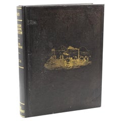
Report upon the Colorado River of the West by Joseph Ives, First Edition, 1861
Located in Colorado Springs, CO
Ives, Joseph Christmas. Report upon the Colorado River of the West. Washington: Government Printing Office, 1861. First Edition, Senate Issue. Extensively illustrated with maps, engr...
Category
Antique 1860s American Books
Materials
Fabric, Paper
1859 "Map of the United States of America..." by J. H. Colton
By J.H. Colton
Located in Colorado Springs, CO
Presented is an 1859 “Map of the United States of America, the British Provinces, Mexico, the West Indies and Central America with Part of...
Category
Antique 1850s American Maps
Materials
Paper

1864 Map of North America, Antique Hand-Colored Map, by Adolphe Hippolyte Dufour
Located in Colorado Springs, CO
Offered is a map of North America entitled Amerique du Nord from 1864. This rare, separately published wall map was produced by Adolphe Hippolyte Dufour. This map includes vibrant an...
Category
Antique 1860s French Maps
Materials
Paper

Recently Viewed
View AllMore Ways To Browse
George Coronation
German Christmas Ornaments
Hand Crank
Neil Armstrong
Rare Christmas
Ulysses S Grant
Vintage Christmas Ornament
Mercury Glass Ornaments
Antique German Christmas
Mid Century Christmas Tree
German Antique Ornaments
German Glass Christmas Ornaments
Blown Glass Christmas
Masonic Furniture
Antique Coffe Grinder
Antique Coffee Grinder
Artillery Shell
Historical Signatures