Items Similar to Antique Hand-Colored Print of Sister of the Third Order of St. Francis

Want more images or videos?
Request additional images or videos from the seller
1 of 6
Antique Hand-Colored Print of Sister of the Third Order of St. Francis
About the Item
Antique print titled 'Soeur du Tiers Ordre des Servites'. Print of a Sister of the Third Order. This print originates from 'Histoire et Costumes des Ordres Religieux'.
Artists and Engravers: Author: Abbé Tiron.
Condition: Good, general age-related toning. Minor wear and foxing, blank verso. Protective sheet attached. Please study image carefully.
Date: 1845
Overall size: 16 x 25.5 cm.
Image size: 7 x 15 cm.
We sell original antique maps to collectors, historians, educators and interior decorators all over the world. Our collection includes a wide range of authentic antique maps from the 16th to the 20th centuries. Buying and collecting antique maps is a tradition that goes back hundreds of years. Antique maps have proved a richly rewarding investment over the past decade, thanks to a growing appreciation of their unique historical appeal. Today the decorative qualities of antique maps are widely recognized by interior designers who appreciate their beauty and design flexibility. Depending on the individual map, presentation, and context, a rare or antique map can be modern, traditional, abstract, figurative, serious or whimsical. We offer a wide range of authentic antique maps for any budget.
- Dimensions:Height: 10.04 in (25.5 cm)Width: 6.3 in (16 cm)Depth: 0 in (0.01 mm)
- Materials and Techniques:
- Period:
- Date of Manufacture:1845
- Condition:Condition: Good, general age-related toning. Minor wear and foxing, blank verso. Protective sheet attached. Please study image carefully.
- Seller Location:Langweer, NL
- Reference Number:Seller: BG-12444-1-571stDibs: LU3054329304662
About the Seller
5.0
Recognized Seller
These prestigious sellers are industry leaders and represent the highest echelon for item quality and design.
Platinum Seller
Premium sellers with a 4.7+ rating and 24-hour response times
Established in 2009
1stDibs seller since 2017
2,423 sales on 1stDibs
Typical response time: <1 hour
- ShippingRetrieving quote...Shipping from: Langweer, Netherlands
- Return Policy
Authenticity Guarantee
In the unlikely event there’s an issue with an item’s authenticity, contact us within 1 year for a full refund. DetailsMoney-Back Guarantee
If your item is not as described, is damaged in transit, or does not arrive, contact us within 7 days for a full refund. Details24-Hour Cancellation
You have a 24-hour grace period in which to reconsider your purchase, with no questions asked.Vetted Professional Sellers
Our world-class sellers must adhere to strict standards for service and quality, maintaining the integrity of our listings.Price-Match Guarantee
If you find that a seller listed the same item for a lower price elsewhere, we’ll match it.Trusted Global Delivery
Our best-in-class carrier network provides specialized shipping options worldwide, including custom delivery.More From This Seller
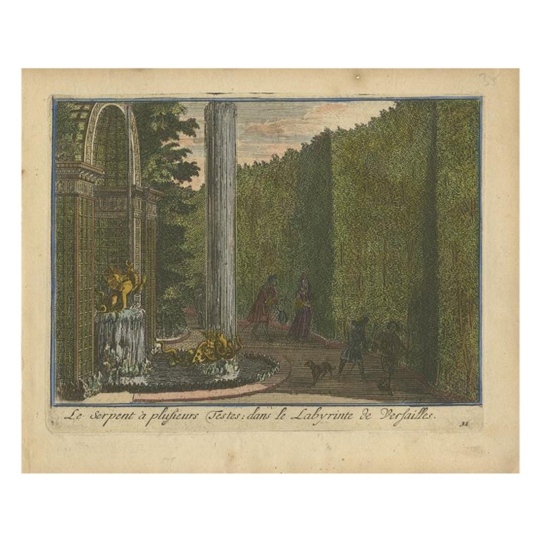
View AllAntique Hand-Colored Print of the Labyrinth of Versailles, c.1720
Located in Langweer, NL
Antique print titled 'Le Serpent à plusieurs Testes: dans le Labyrinte de Versailles'. This print illustrates the fable 'The Snake with several heads' of the labyrinth of Versailles ...
Category
Antique 18th Century Prints
Materials
Paper

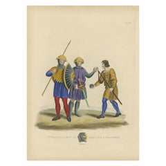
Antique Hand-Colored Print of a Spearman, 1842
Located in Langweer, NL
Antique print titled 'A Spearman, Man at Arms and a Slinger'. Old print of a spearman, slinger and man at arms. This print originates from 'A critical inquiry into antient armour as ...
Category
Antique 19th Century Prints
Materials
Paper
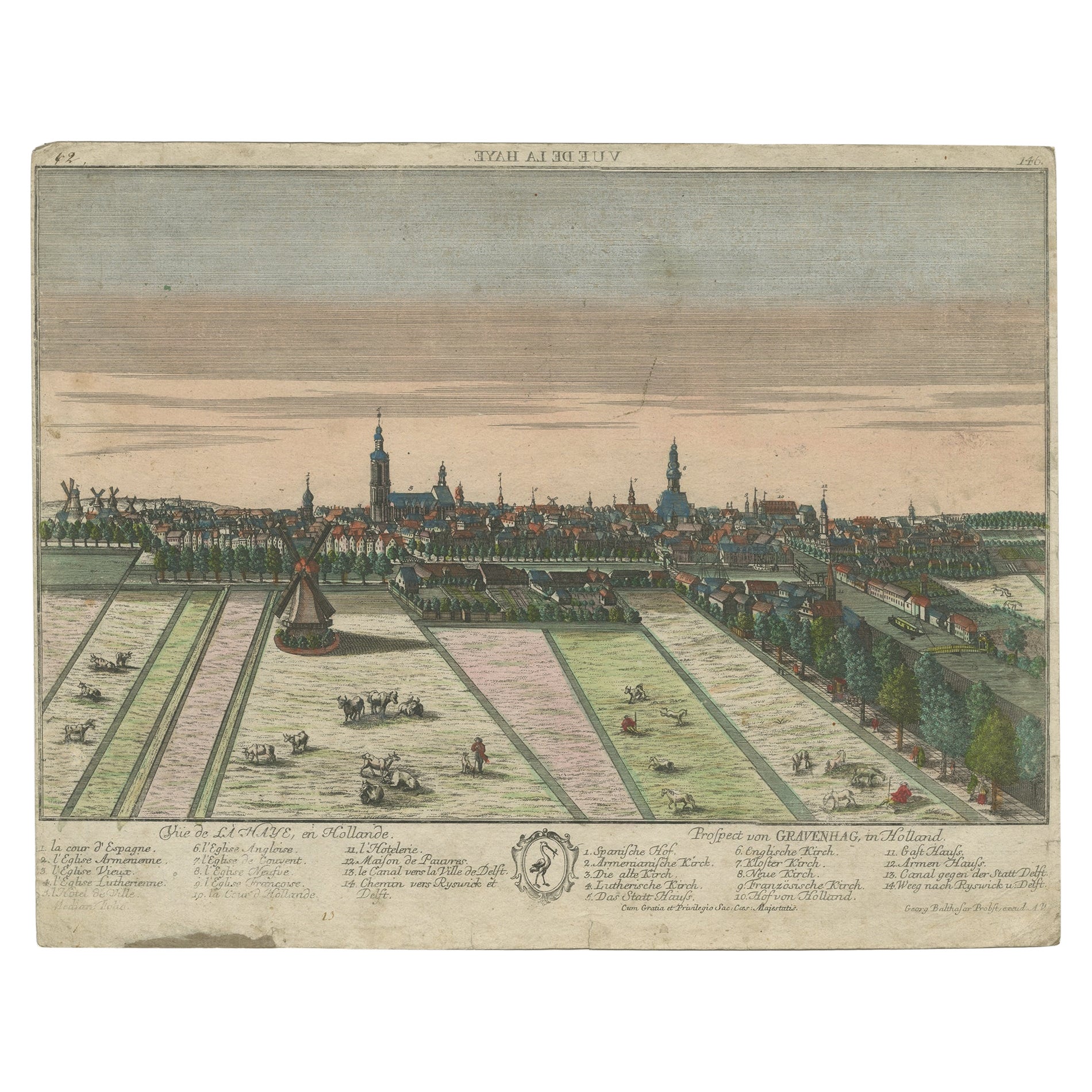
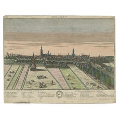
Original Antique Hand-Colored Optica Print of the Hague, C.1760
Located in Langweer, NL
Antique print titled 'Vue de la Haye en Hollande - Prospect von Gravenhag in Holland'. Beautiful view of The Hague, the Netherlands. This is an optical print, also called 'vue optiqu...
Category
Antique 18th Century Prints
Materials
Paper
$330 Sale Price
20% Off
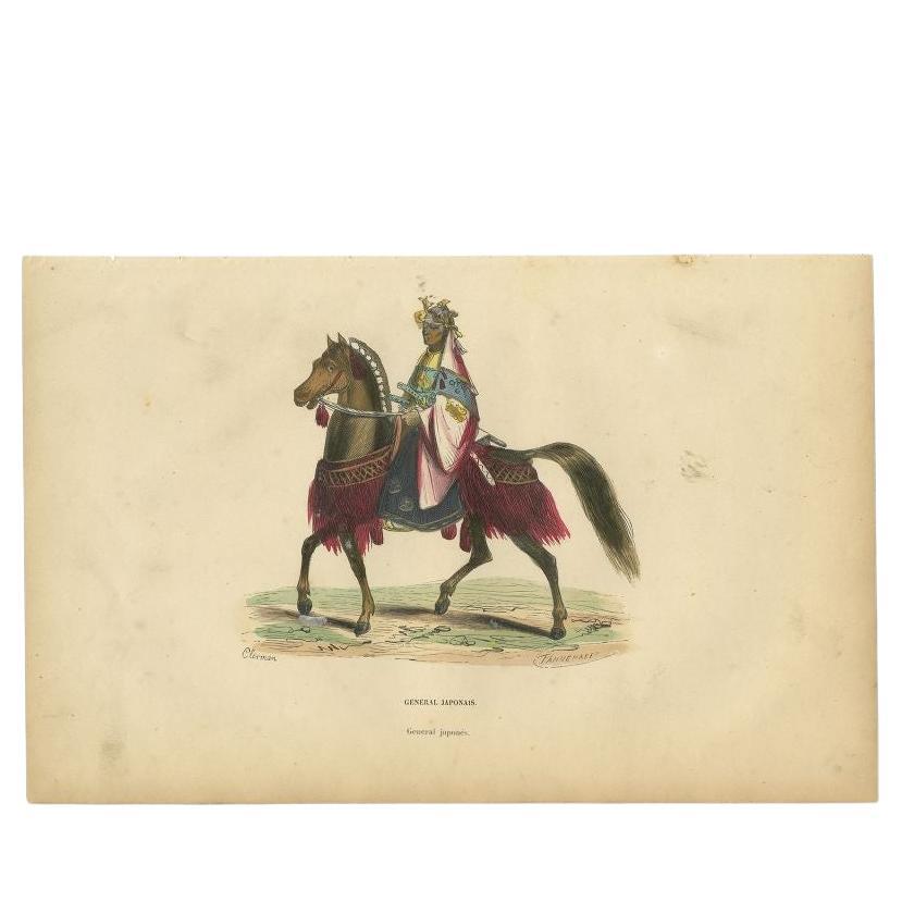
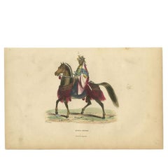
Antique Hand-Colored Print of a Japanese General, 1843
Located in Langweer, NL
Antique costume print titled 'General Japonais'. Original antique print of a Japanese general. This print originates from 'Moeurs, usages et costumes de tous les peuples du monde' by...
Category
Antique 19th Century Prints
Materials
Paper
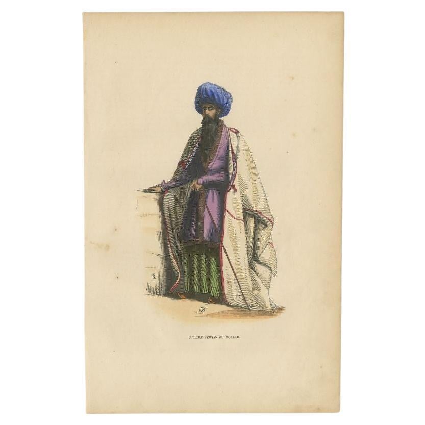
Antique Hand-Colored Print of a Persian Priest, 1843
Located in Langweer, NL
Antique costume print titled 'Pretre Persan ou Mollah'. Original antique print of a Persian Priest. This print originates from 'Moeurs, usages et costumes de tous les peuples du mond...
Category
Antique 19th Century Prints
Materials
Paper

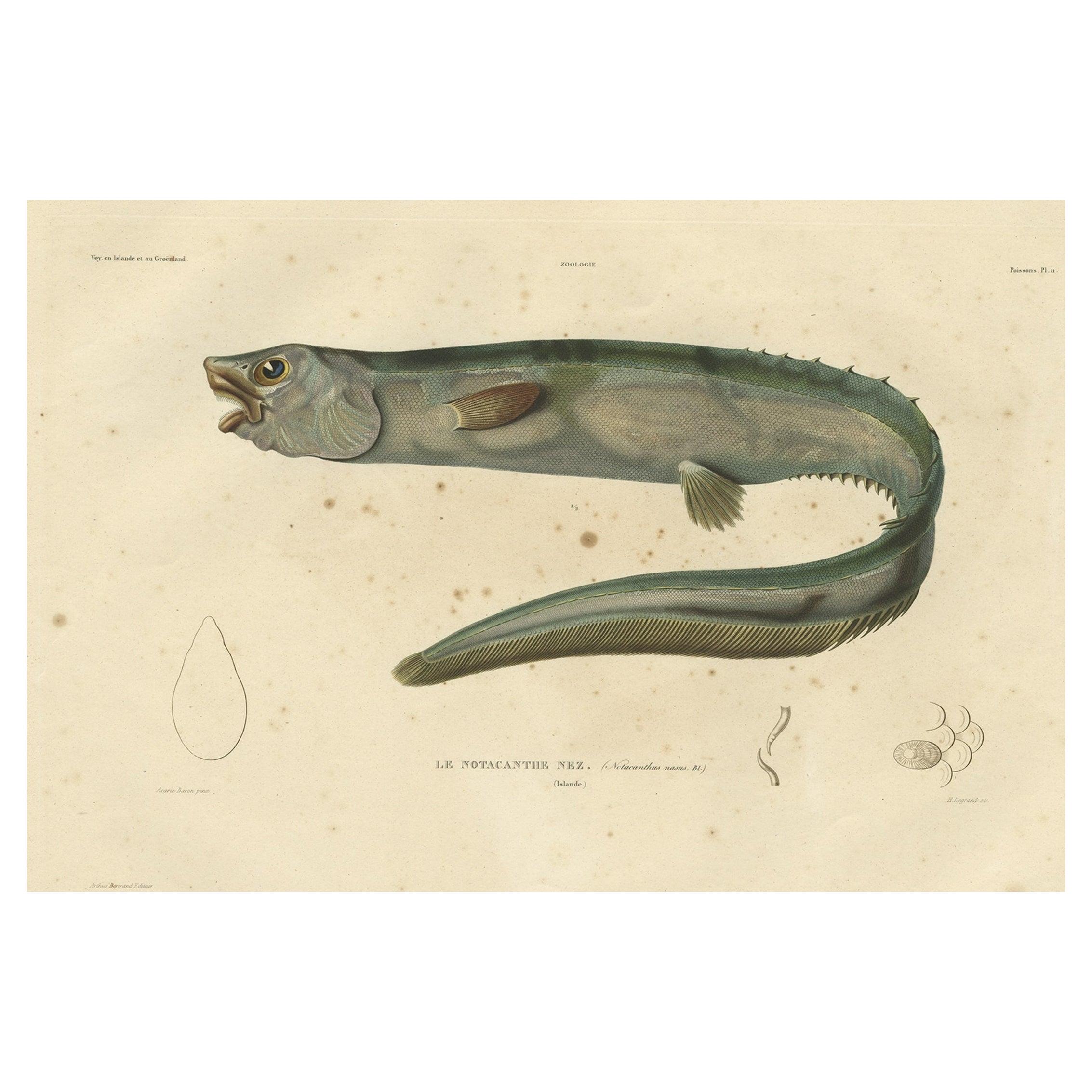
Antique Hand-Colored Fish Print of the Snub-Nosed Spiny Eel, 1842
Located in Langweer, NL
Antique print, titled: 'Poissons Plate 11 - Le Notacanthe Nez (Notacanthus nasus).' - This rare plate shows the snub-nosed spiny eel (Notacanthus chemnitzii). From: 'Voyage en Island...
Category
Antique 1840s Prints
Materials
Paper

You May Also Like
St. Christophe 'St. Kitts' Island: An 18th Century Hand-colored Map by Bellin
By Jacques-Nicolas Bellin
Located in Alamo, CA
Jacques Bellin's copper-plate map of the Caribbean island of Saint Kitts entitled "Carte De De l'Isle St. Christophe Pour servir á l'Histoire Genle. des V...
Category
Antique Mid-18th Century French Maps
Materials
Paper

Hand-Colored 18th Century Homann Map of the Danube, Italy, Greece, Croatia
By Johann Baptist Homann
Located in Alamo, CA
"Fluviorum in Europa principis Danubii" is a hand colored map of the region about the Danube river created by Johann Baptist Homann (1663-1724) in his 'Atlas Novus Terrarum', publish...
Category
Antique Early 18th Century German Maps
Materials
Paper

The Normandy Region of France: A 17th C. Hand-colored Map by Sanson and Jaillot
By Nicolas Sanson
Located in Alamo, CA
This large hand-colored map entitled "Le Duché et Gouvernement de Normandie divisée en Haute et Basse Normandie en divers Pays; et par evêchez, avec le Gouvernement General du Havre ...
Category
Antique 1690s French Maps
Materials
Paper

The Kingdom of Naples and Southern Italy: A Hand-Colored 18th Century Homann Map
By Johann Baptist Homann
Located in Alamo, CA
"Novissima & exactissimus Totius Regni Neapolis Tabula Presentis Belli Satui Accommo Data" is a hand colored map of southern Italy and the ancient Kingdom of Naples created by Johann...
Category
Antique Early 18th Century German Maps
Materials
Paper

Hand Colored 18th Century Homann Map of Austria Including Vienna and the Danube
By Johann Baptist Homann
Located in Alamo, CA
"Archiducatus Austriae inferioris" is a hand colored map of Austria created by Johann Baptist Homann (1663-1724) and published in Nuremberg, Germany in 1728 shortly after his death. ...
Category
Antique Early 18th Century German Maps
Materials
Paper

17th Century Hand Colored Map of the Liege Region in Belgium by Visscher
By Nicolaes Visscher II
Located in Alamo, CA
An original 17th century map entitled "Leodiensis Episcopatus in omnes Subjacentes Provincias distincté divisusVisscher, Leodiensis Episcopatus" by Nicolaes Visscher II, published in Amsterdam in 1688. The map is centered on Liege, Belgium, includes the area between Antwerp, Turnhout, Roermond, Cologne, Trier and Dinant.
This attractive map is presented in a cream-colored mat measuring 30" wide x 27.5" high. There is a central fold, as issued. There is minimal spotting in the upper margin and a tiny spot in the right lower margin, which are under the mat. The map is otherwise in excellent condition.
The Visscher family were one of the great cartographic families of the 17th century. Begun by Claes Jansz Visscher...
Category
Antique Late 17th Century Dutch Maps
Materials
Paper
