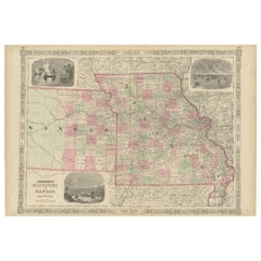
1865 "Johnson's Missouri and Kansas" Map by Johnson and Ward
View Similar Items


Want more images or videos?
Request additional images or videos from the seller
1 of 10
1865 "Johnson's Missouri and Kansas" Map by Johnson and Ward
About the Item
- Dimensions:Height: 23 in (58.42 cm)Width: 29 in (73.66 cm)Depth: 0.75 in (1.91 cm)
- Materials and Techniques:
- Period:
- Date of Manufacture:1865
- Condition:Additions or alterations made to the original: Archivally framed with acid-free mats, UV conservation clear glass, and a custom wooden frame. Framed by Rio Grande Framing Co in Colorado Springs, CO in October of 2023. Wear consistent with age and use. Toning, few areas of foxing.
- Seller Location:Colorado Springs, CO
- Reference Number:Seller: M3531stDibs: LU909738901352
About the Seller
4.9
Platinum Seller
Premium sellers with a 4.7+ rating and 24-hour response times
Established in 2010
1stDibs seller since 2011
452 sales on 1stDibs
Typical response time: 1 hour
Authenticity Guarantee
In the unlikely event there’s an issue with an item’s authenticity, contact us within 1 year for a full refund. DetailsMoney-Back Guarantee
If your item is not as described, is damaged in transit, or does not arrive, contact us within 7 days for a full refund. Details24-Hour Cancellation
You have a 24-hour grace period in which to reconsider your purchase, with no questions asked.Vetted Professional Sellers
Our world-class sellers must adhere to strict standards for service and quality, maintaining the integrity of our listings.Price-Match Guarantee
If you find that a seller listed the same item for a lower price elsewhere, we’ll match it.Trusted Global Delivery
Our best-in-class carrier network provides specialized shipping options worldwide, including custom delivery.More From This Seller
View All1890 "Map of Oregon, Kansas, California, and the Territories" by S. A. Mitchell
By Samuel Augustus Mitchell 1
Located in Colorado Springs, CO
Presented is an 1890 map "Map of Oregon, Kansas, California, and the Territories" by S. A. Mitchell Jr. The map was issued in the atlas “Mitchell's New Intermediate Geography” publis...
Category
Antique 1890s American Victorian Maps
Materials
Paper

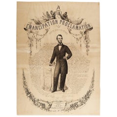
1865 Emancipation Proclamation, Antique Lithograph by P.S. Duval and Son
Located in Colorado Springs, CO
Presented is a lithographic broadside of the text of the Emancipation Proclamation issued on January 1, 1863. This broadside was published in...
Category
Antique 1860s American Historical Memorabilia
Materials
Paper
"Lady Washington's Reception, " Engraved by A. H. Ritchie, Antique Print, 1865
Located in Colorado Springs, CO
This 1865, hand-colored engraving by A. H. Ritchie is entitled Lady Washington's Reception and is based on Daniel F. Huntington's original painting "Th...
Category
Antique 1860s American Prints
Materials
Paper

1854 Map of Massachusetts, Connecticut and Rhode Island, Antique Wall Map
Located in Colorado Springs, CO
This striking wall map was published in 1854 by Ensign, Bridgman & Fanning and has both full original hand-coloring and original hardware. This impression is both informative and highly decorative.
The states are divided into counties, outlined in red, green, and black, and subdivided into towns. Roads, canals, and railroad lines are prominently depicted, although they are not all labeled. The mapmakers also marked lighthouses, banks, churches, and prominent buildings, with a key at right. The map is an informative and comprehensive overview of the infrastructural development of New England prior to the Civil War. Physical geographies depicted include elevation, conveyed with hachure marks, rivers and lakes. The impression features an inset map of Boston...
Category
Antique 19th Century American Maps
Materials
Paper

1812 United States Map, by Pierre Tardieu, Antique French Map Depicting the U.S.
By Pierre François Tardieu
Located in Colorado Springs, CO
1812 "United States of Nth America -- Carte des Etats-Unis De L'Amerique Septentrionale" Two-Sheet Map by Tardieu
This attractive map, published in Paris in 1812, is one of the most rare large format maps from the period. It features a view of the East Coast of the U.S. from Maryland to just below South Carolina. Additionally, Ellicott’s plan for the City of Washington D.C. is included at the top right and an illustration of Niagara Falls is shown at the bottom right with a description in both French and English. This extremely detailed map not only depicts the mountainous regions of the southeastern U.S., but also includes names of regions, rivers, and towns.
Based on the first state of Arrowsmith’s 4-sheet map of the United States, this map is completely engraved by Tardieu in Paris and showcases high quality engravings. This detailed map of the recently independent United States includes one of the largest and earliest examples of the Ellicott plan of Washington DC.
The artist, Pierre François Tardieu (PF Tardieu) was a very well-known map engraver, geographer, and illustrator. Awarded a bronze medal by King Louis-Phillipe for the accuracy and beauty of his map-making, Tardieu produced many fine works including maps of Louisiana...
Category
Antique 1810s French Maps
Materials
Paper

1864 Map of North America, Antique Hand-Colored Map, by Adolphe Hippolyte Dufour
Located in Colorado Springs, CO
Offered is a map of North America entitled Amerique du Nord from 1864. This rare, separately published wall map was produced by Adolphe Hippolyte Dufour. This map includes vibrant an...
Category
Antique 1860s French Maps
Materials
Paper

You May Also Like
1862 Johnson's Map of New York State by Johnson & Browning
Located in Langweer, NL
Title: 1862 Johnson's Map of New York State by Johnson & Browning
Description:This is an 1862 map of New York State, titled "Johnson's New York," created by Johnson & Browning. The ...
Category
Antique 1860s Maps
Materials
Paper

$260 Sale Price
20% Off
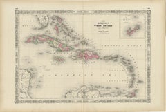
1864 Johnson's Map of the West Indies and Bermuda
Located in Langweer, NL
Title: 1864 Johnson's Map of the West Indies and Bermuda
Description: This is an 1864 map titled "Johnson's West Indies," published by Johnson and Ward. The map provides a detailed ...
Category
Antique 1860s Maps
Materials
Paper
$297 Sale Price
20% Off
Historic Map of Missouri and Kansas Showing Railroads and Frontier Trails, 1864
Located in Langweer, NL
Antique 1864 Map of Missouri and Kansas by Johnson and Ward
Description:
This finely detailed and vibrantly hand-colored map of Missouri and Kansas, publ...
Category
Antique 1860s Maps
Materials
Paper
1864 Johnson's Map of New York State with City Insets
Located in Langweer, NL
Title: 1864 Johnson's Map of New York State with City Insets
Description: This 1864 map, titled "Johnson's New York," was published by Johnson and Ward and features a detailed depic...
Category
Antique 1860s Maps
Materials
Paper

$260 Sale Price
20% Off
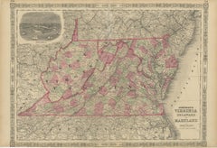
1864 Johnson's Map of Virginia, Delaware, and Maryland with Fort Monroe Inset
Located in Langweer, NL
Title: 1864 Johnson's Map of Virginia, Delaware, and Maryland with Fort Monroe Inset
Description: This 1864 map titled "Johnson's Virginia, Delaware, and ...
Category
Antique 1860s Maps
Materials
Paper
$279 Sale Price
20% Off
1864 Johnson's Map of the World on Mercator's Projection, Ric.B009
Located in Norton, MA
An 1864 Johnson's map of
the World on Mercator's Projection
Ric.b009
About this Item
"This antique map came from Johnson's New Illustrated (Steel Plate) Family Atlas, publ...
Category
Antique 19th Century Dutch Maps
Materials
Paper

Recently Viewed
View AllMore Ways To Browse
Antique Boot Jack
Antique Bottle Glass Windows
Antique Brass Binoculars
Antique Brass Goblet
Antique Brass Microscope Scientific Instruments
Antique Celtic Cross
Antique Chairs Philippines
Antique Childs Vanity
Antique Childs Writing Desk
Antique Coconut Cups
Antique Cut Glass Water Pitcher
Antique Doctors Scale
Antique Dog Carrier
Antique Drafting Table Desks
Antique Dragon Bench
Antique English China Crown Derby
Antique English Pub Table
Antique Exeter Silver