Items Similar to 1875 "North America" Map by J. Bartholomew


Video Loading
Want more images or videos?
Request additional images or videos from the seller
1 of 7
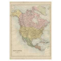
1875 "North America" Map by J. Bartholomew
About the Item
Presented is an original 1875 map of “North America.” The map was issued in Volume 1 of the Ninth Edition of the Encyclopædia Britannica, published in Edinburgh. The map was drawn by famous Scottish mapmaker John Bartholomew. The map depicts North America, to include Greenland, the Dominion of Canada, the United States, Mexico, the countries of Central America, and the islands of the West Indies. Prominent rivers, mountain ranges, and cities are labeled on the map, and country borders are emphasized in red.
The Encyclopædia Britannica has been published continuously since 1768, appearing in fifteen official editions. The landmark ninth edition of the Encyclopædia Britannica, often called "the Scholar's Edition," was published from January 1875 to 1889 in 25 volumes. The editor and author of the “Foreword” was Thomas Spencer Baynes, the first English-born editor after a series of Scots. After 1880, Baynes was assisted by William Robertson Smith. The 9th edition is often lauded as a high point among early editions for scholarship.
The 9th edition was far more luxurious than any previously printed Encyclopædia Britannicas, with thick boards and quality leather bindings, premier paper, and a production which took full advantage of the technological advances of printing in the years between the 1850s and 1870s. The publishers took advantage of the new ability to print large graphic illustrations on the same pages as the text, as opposed to limiting illustrations to separate copper plate engravings. Although this technology had first been used in a primitive fashion the 7th edition, and to a much lesser extent in the 8th, in the 9th edition there were thousands of quality illustrations and maps set into the text pages, in addition to the plates. The 9th edition was a critical success, and roughly 8,500 sets were sold in Britain.
CONDITION:
Very good condition. Color printed map. Color is original to the map and still vibrant. Minor toning to paper. Two small spots of foxing along the left side. Artist and publication information is printed at the bottom of the map: At bottom right margin "J. Bartholomew, Edin." At bottom center "Encyclopædia Britannica, Ninth Edition" Along the right side margin, "Vol I. North America. Plate X. " Map measures 14 10/16” x 10 1/2”.
Map has been artfully framed to archival standards, with acid-free mats, UV glass, and a custom-built black wooden frame. Framed Dimensions: 19" H x 15" W x 1 1/8" D.
- Dimensions:Height: 19 in (48.26 cm)Width: 15 in (38.1 cm)Depth: 1.13 in (2.88 cm)
- Materials and Techniques:
- Place of Origin:
- Period:
- Date of Manufacture:1875
- Condition:Additions or alterations made to the original: Archival framing by Rio Grande Custom Framing in Boulder, Colorado, in April of 2023. Wear consistent with age and use.
- Seller Location:Colorado Springs, CO
- Reference Number:
About the Seller
4.9
Platinum Seller
These expertly vetted sellers are 1stDibs' most experienced sellers and are rated highest by our customers.
Established in 2010
1stDibs seller since 2011
400 sales on 1stDibs
Typical response time: <1 hour
- ShippingRetrieving quote...Ships From: Colorado Springs, CO
- Return PolicyA return for this item may be initiated within 10 days of delivery.
More From This SellerView All
- 1864 Map of North America, Antique Hand-Colored Map, by Adolphe Hippolyte DufourLocated in Colorado Springs, COOffered is a map of North America entitled Amerique du Nord from 1864. This rare, separately published wall map was produced by Adolphe Hippolyte Dufour. This map includes vibrant an...Category
Antique 1860s French Maps
MaterialsPaper
- 1859 "Map of the United States of America..." by J. H. ColtonBy J.H. ColtonLocated in Colorado Springs, COPresented is an 1859 “Map of the United States of America, the British Provinces, Mexico, the West Indies and Central America with Part of...Category
Antique 1850s American Maps
MaterialsPaper
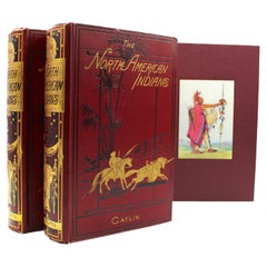
- North American Indians by George Catlin, Two Volumes, First Grant Edition, 1926By George CatlinLocated in Colorado Springs, COCatlin, George. North American Indians: Being Letters and Notes on Their Manners, Customs, and Conditions, Written During Eight Years' Travel Amongst the Wildest Tribes of Indians in...Category
Vintage 1920s Scottish Books
MaterialsPaper
- 1907 Map of Colorado, Antique Topographical Map, by Louis NellLocated in Colorado Springs, COThis highly detailed pocket map is a topographical map of the state of Colorado by Louis Nell from 1907. The map "has been complied from all availabl...Category
Antique Early 1900s American Maps
MaterialsPaper
- "Clason's Guide Map of Montana" by The Clason Map Company, Circa 1920sLocated in Colorado Springs, COPresented is “Clason's Guide Map of Montana,” published in the early 1920s by the Clason Map Company. Issued as a folding map, this map identifies county boundaries, county seats, Na...Category
Vintage 1920s American Art Deco Maps
MaterialsPaper
- 1861 Topographical Map of the District of Columbia, by Boschke, Antique MapLocated in Colorado Springs, COPresented is an original map of Albert Boschke's extremely sought-after "Topographical Map of the District of Columbia Surveyed in the Years 1856 ...Category
Antique 1860s American Historical Memorabilia
MaterialsPaper


You May Also Like
- Antique Map of North America by Levasseur '1875'Located in Langweer, NLAntique map titled 'Carte générale de l'Amérique Septentrionale'. Large map of North America. This map originates from 'Atlas de Géographie Modern...Category
Antique Late 19th Century Maps
MaterialsPaper
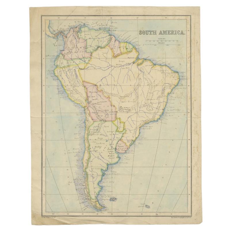
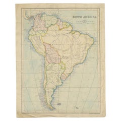
- Antique Map of South America by Philip & Son, 1875Located in Langweer, NLAntique map titled 'South America'. Old map of South America. Source unknown, to be determined. Artists and Engravers: George Philip (1800–1882) was a cartographer, map publisher...Category
Antique 19th Century Maps
MaterialsPaper
- Antique Map of North America by Johnston, 1882By Alexander Keith JohnstonLocated in Langweer, NLAntique map titled 'North America'. Old map of North America. This map originates from 'The Royal Atlas of Modern Geography, Exhibiting, in a Series of Entirely Original and Authen...Category
Antique 19th Century Maps
MaterialsPaper
- Antique Map of North America by A & C. Black, 1870Located in Langweer, NLAntique map titled 'North America'. Original antique map of North America. This map originates from ‘Black's General Atlas of The World’. Published by A & C. Black, 1870.Category
Antique Late 19th Century Maps
MaterialsPaper
- Antique Map of North America by Lowry '1852'Located in Langweer, NLAntique map titled 'North America'. Original map of North America. This map originates from 'Lowry's Table Atlas constructed and engraved from the...Category
Antique Mid-19th Century Maps
MaterialsPaper
- Antique Map of North America by Johnson, '1872'Located in Langweer, NLAntique map titled 'Johnson's North America'. Original map of North America, with an inset map of the Hawaiian group or Sandwich Islands. This map originates from 'Johnson's New Illu...Category
Antique Late 19th Century Maps
MaterialsPaper


Recently Viewed
View AllMore Ways To Browse
Antique Furniture North West
Antique Side Boards
Antique Side Board Antiques
1850s American
Scottish Borders
Black Leather Red Bottoms
Antique Center Islands
Antique Country Primitives
The Scots
Set Of Scottish Glasses
Thomas Toner
Wooden Printing
Antique Country Furniture Of North America
West Indies Prints
William Spencer
Antique Maps Canada
Antique Map Canada
West Indies Map