Items Similar to 1879 Map of the United States, Showing the Santa Fe Railroad by GW & CB Colton


Want more images or videos?
Request additional images or videos from the seller
1 of 11
1879 Map of the United States, Showing the Santa Fe Railroad by GW & CB Colton
About the Item
Presented is an original "General Map of the United States Showing the Lines of the Atchison, Topeka & Santa Fe Railroad and Its Connections with the Sea Ports". Undated, this map was published in New York by G.W. & C.B. Colton, circa 1879. This small, folding map of the United States highlights various railroad routes of the Atchison, Topeka & Santa Fe Railroad in bright red, extending from east coast ports like Halifax, Boston, New York and Philadelphia to St. Louis, Chicago, and Atchison, Lead Valley and Pueblo in Colorado, extending into the Southwest with Santa Fe, San Diego, and ending in the Mexican cities of Guaymas and Chihuahua. It includes a small inset map of Britain at the bottom left, drawn to scale for sheer size comparison.
The verso of the map features three panels of German text titled "Amerika," marketing settlement to the rich agricultural lands of southwest Kansas owned by the railroad. One section of text, translated, states that “Kansas should be called ‘Mesopotamia’ because of its fertility, and its rivers, Kansas and Arkansas, the ‘Euphrates’ and ‘Tigris’, should indeed be called one of the pearls of North America, and whoever has once visited them must join in the general praise of Kansas' agricultural conditions." Another section boasts that “the Atchison, Topeka, and Santa Fe Railroad is the facilitator of a magnificent traffic route between the mining regions of the Rocky Mountains and the great breadbasket of the continent. It runs through the richest regions of Kansas and connects them with the silver and gold-producing mountains, where the products of Kansas farms find a profitable market.” The Santa Fe railroad actively and successfully promoted settlement in Kansas among German communities in Europe, with maps and pamphlets just like this one.
Founded in 1859, the Atchison, Topeka and Santa Fe Railway was created to connect the Kansas frontier town of Atchison with the growing trade routes of the American Southwest. But what began as a regional railroad soon became one of the largest and most influential railroads in the United States, stretching from the Midwest to the Pacific. The Santa Fe Railway forged paths into previously inaccessible regions, bringing infrastructure, settlers, and commerce to the American West. Unlike other railroads that primarily served established cities, the Santa Fe created new towns just by laying track across vast, unsettled land. It gave rise to dozens of communities and helped make states like New Mexico, Arizona, and California more accessible and economically viable.
The Santa Fe railway was a powerful engine of economic change- transporting cattle, minerals, lumber, and agricultural products from the West to markets in the East and Midwest. It played a critical role in the cattle boom of Texas and Oklahoma and helped turn the arid lands of the Southwest into productive agricultural hubs through irrigation efforts. The Santa Fe made it possible for small frontier settlements to connect with national markets. The resulting economic growth reshaped not only the Western states, but the national economy as a whole.
CONDITION:
Very good condition. Issued folding, with light creasing along fold lines as expected. Engraving with original handcoloring, in light water color wash of pink, green, yellow. With red overprinting, marking railroad routes. Small inset map of England, Scotland, and Wales at bottom left. Publisher’s line, “Prepared by G.W. & C.B. Colton & Co. New York,” printed at bottom right margin. Minor toning and small stain at top. Verso has three printed panels of German text, with pen inked inscription at bottom right “Philipp Behrene, aus Rodenberg, Station Haste Nendorft.” Map Dimensions: 5.2” H x 8.9” W.
Archivally framed, with acid-free dark mats, UV glass, and custom wooden frame with gold beaded spandrel.
Framed Dimensions:9 3/4"H x 12 7/8"W x 5/8"D.
Accompanied by our company's letter of authenticity.
- Creator:G.W. & C.B. Colton (Maker)
- Dimensions:Height: 9.75 in (24.77 cm)Width: 12.88 in (32.72 cm)Depth: 0.63 in (1.61 cm)
- Style:High Victorian (Of the Period)
- Materials and Techniques:
- Place of Origin:
- Period:
- Date of Manufacture:1879
- Condition:Additions or alterations made to the original: Archivally framed by Artem Art Services in Colorado Springs, Colorado, in April of 2025. Wear consistent with age and use.
- Seller Location:Colorado Springs, CO
- Reference Number:Seller: M3911stDibs: LU909745141392
About the Seller
4.9
Platinum Seller
Premium sellers with a 4.7+ rating and 24-hour response times
Established in 2010
1stDibs seller since 2011
449 sales on 1stDibs
Typical response time: <1 hour
- ShippingRetrieving quote...Shipping from: Colorado Springs, CO
- Return Policy
Authenticity Guarantee
In the unlikely event there’s an issue with an item’s authenticity, contact us within 1 year for a full refund. DetailsMoney-Back Guarantee
If your item is not as described, is damaged in transit, or does not arrive, contact us within 7 days for a full refund. Details24-Hour Cancellation
You have a 24-hour grace period in which to reconsider your purchase, with no questions asked.Vetted Professional Sellers
Our world-class sellers must adhere to strict standards for service and quality, maintaining the integrity of our listings.Price-Match Guarantee
If you find that a seller listed the same item for a lower price elsewhere, we’ll match it.Trusted Global Delivery
Our best-in-class carrier network provides specialized shipping options worldwide, including custom delivery.More From This Seller
View All1859 "Map of the United States of America..." by J. H. Colton
By J.H. Colton
Located in Colorado Springs, CO
Presented is an 1859 “Map of the United States of America, the British Provinces, Mexico, the West Indies and Central America with Part of...
Category
Antique 1850s American Maps
Materials
Paper

1847 Ornamental Map of the United States & Mexico by H. Phelps
Located in Colorado Springs, CO
Offered is an original 1847 ornamental map of the U.S. entitled "Ornamental Map of the United States & Mexico" by Humphrey Phelps. The map was issued as an act of Congress by Phelps on Fulton Street, New York. The broadside is elaborately hand-colored.
This is a very detailed and graphic propaganda map of the United States expressing U.S. dominance of the North American continent. The hand-colored map proclaims the Manifest Destiny, with the recent acquisition of Upper California and Texas at the conclusion of the Mexican-American War. The newly acquired land is boldly colored, standing in stark contrast to the rest of the U.S. The map details a potential route for a railroad running from New York City, to Buffalo, to Chicago, then west along the Oregon Trail to Oregon City. This route anticipates the construction of the transcontinental railroad by nearly 20 years.
The map includes elaborately detailed renderings of George Washington, Hernan Cortez, and Montezuma at top to represent European expansion to the Americas. At bottom are four inset designs with text showing the following: a chronological history of the U.S. beginning from settlement to the U.S. victory in the Mexican-American war; an illustration of General Zachary Taylor with details on the Oregon Territory; an illustration of the Aztec Temple of the Sun in Tenochtitlan and a chronology of the Conquest of the Aztec Empire under Cortez; a portrait of General Antonio Lopez de Santa Anna...
Category
Antique 1840s American Maps
Materials
Paper

1866 Ensign & Bridgman's Rail Road Map of the United States
Located in Colorado Springs, CO
Presented is an 1866 issue of “Ensign & Bridgeman’s Rail Road Map of the United States, showing Depots & Stations.” First published in 1856, this is the third edition, following anot...
Category
Antique 1860s American Late Victorian Maps
Materials
Paper

1939 "A Good-Natured Map of the United States" by Greyhound
Located in Colorado Springs, CO
Presented is an original 1939 map, titled “A Good-Natured Map of the United States Setting Forth the Services of the Greyhound Lines and a Few Principal Connecting Bus Lines.” This brightly colored pictographic map was one of several similar United States maps...
Category
Vintage 1930s American Art Deco Maps
Materials
Paper

1842 Wall Map of the United States by J. H. Young, Published by S. A. Mitchell
Located in Colorado Springs, CO
Presented is an 1842 hanging “Map of the United States,” engraved by J. H. Young and published by Samuel Augustus Mitchell, Philadelphia. This is a beautiful example of the rare 1842...
Category
Antique 1840s American Maps
Materials
Paper

1812 United States Map, by Pierre Tardieu, Antique French Map Depicting the U.S.
By Pierre François Tardieu
Located in Colorado Springs, CO
1812 "United States of Nth America -- Carte des Etats-Unis De L'Amerique Septentrionale" Two-Sheet Map by Tardieu
This attractive map, published in Paris in 1812, is one of the most rare large format maps from the period. It features a view of the East Coast of the U.S. from Maryland to just below South Carolina. Additionally, Ellicott’s plan for the City of Washington D.C. is included at the top right and an illustration of Niagara Falls is shown at the bottom right with a description in both French and English. This extremely detailed map not only depicts the mountainous regions of the southeastern U.S., but also includes names of regions, rivers, and towns.
Based on the first state of Arrowsmith’s 4-sheet map of the United States, this map is completely engraved by Tardieu in Paris and showcases high quality engravings. This detailed map of the recently independent United States includes one of the largest and earliest examples of the Ellicott plan of Washington DC.
The artist, Pierre François Tardieu (PF Tardieu) was a very well-known map engraver, geographer, and illustrator. Awarded a bronze medal by King Louis-Phillipe for the accuracy and beauty of his map-making, Tardieu produced many fine works including maps of Louisiana...
Category
Antique 1810s French Maps
Materials
Paper

You May Also Like
Antique Map Colton's United States of America
Located in Langweer, NL
Antique map titled 'Colton's United States of America'. Show railroads, canals, state capitals, major cities and towns, military posts, historic trails, Pony Express and U.S. mail routes; Dakota [Territory] extending deep into Nebraska, and Idaho [Territory] encompassing [modern day] Montana and Wyoming; Indian Territory...
Category
Antique Mid-19th Century Maps
Materials
Paper

$823 Sale Price
20% Off
Antique Map of the United States of America, also showing the Caribbean
Located in Langweer, NL
Antique map titled 'Verein-Staaten von Nord-America, Mexico, Yucatan u.a.'. Very detailed map of the United States of America showing the ...
Category
Antique Mid-19th Century Maps
Materials
Paper

Antique Railroad Map of the United States by Rand, McNally & Co, 1900
Located in Langweer, NL
Antique map titled 'Rand, McNally & Co's New Official Railroad map of the United States with portions of The Dominion of Canada, The Republic of Mexico and the West Indies'. Large railroad map of the United States, sectionalised and laid on linen. Map shows state boundaries for the United States, Mexico, the West Indies, and lower portion of Canada; major cities and towns, military posts, Native American reservations, and railroads; Oklahoma and "Indian Territory." Inset: "Map of Alaska...
Category
20th Century Maps
Materials
Linen, Paper

$2,167 Sale Price
25% Off
Free Shipping
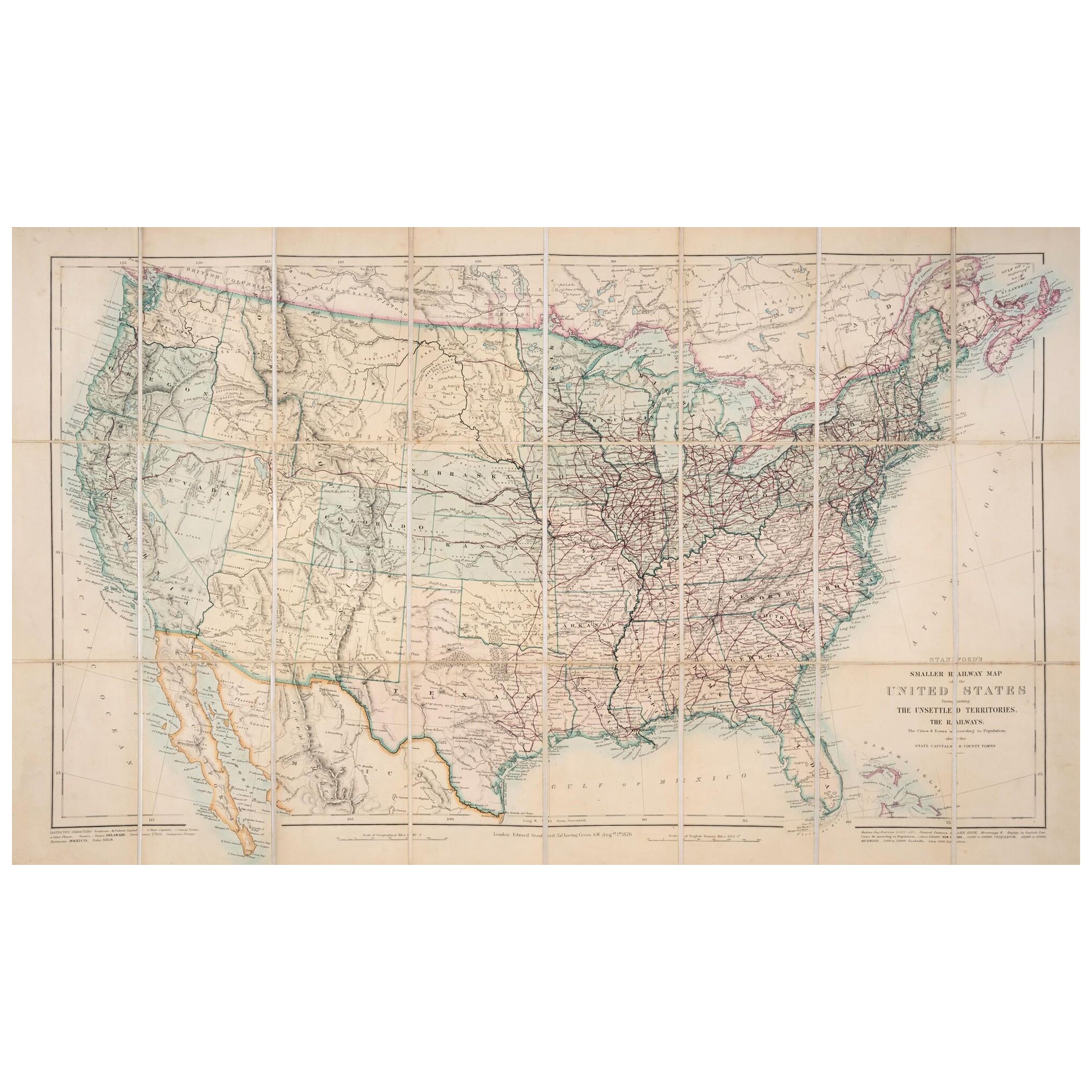
1876 Map of the United States: Detailing the Railroads and Unsettled Territories
Located in Langweer, NL
Stanford’s Smaller Railway Map of the United States, 1876
This original 1876 map, titled "Stanford's Smaller Railway Map of the United States Distinguishing the Unsettled Territorie...
Category
Antique 1870s Maps
Materials
Paper
Small Map of the United States
Located in Langweer, NL
Antique map titled 'Amérique septe. Physique'. Small map of the United States. lithographed by C. Callewaert brothers in Brussels circa 1870.
Category
Antique Mid-19th Century Maps
Materials
Paper

Antique 1844 J Calvin Smith JH Colton Midwest United States Survey Map 27"
By J.H. Colton
Located in Dayton, OH
Antique framed black and white map of seven Midwestern American states. Guide Through Ohio, Michigan, Indiana, Illinois, Missouri, Wisco...
Category
Antique 1840s Maps
Materials
Paper

$940 Sale Price
20% Off