Items Similar to 1882 Map of Queensland, New South Wales, and Victoria with Detailed Features

Want more images or videos?
Request additional images or videos from the seller
1 of 8
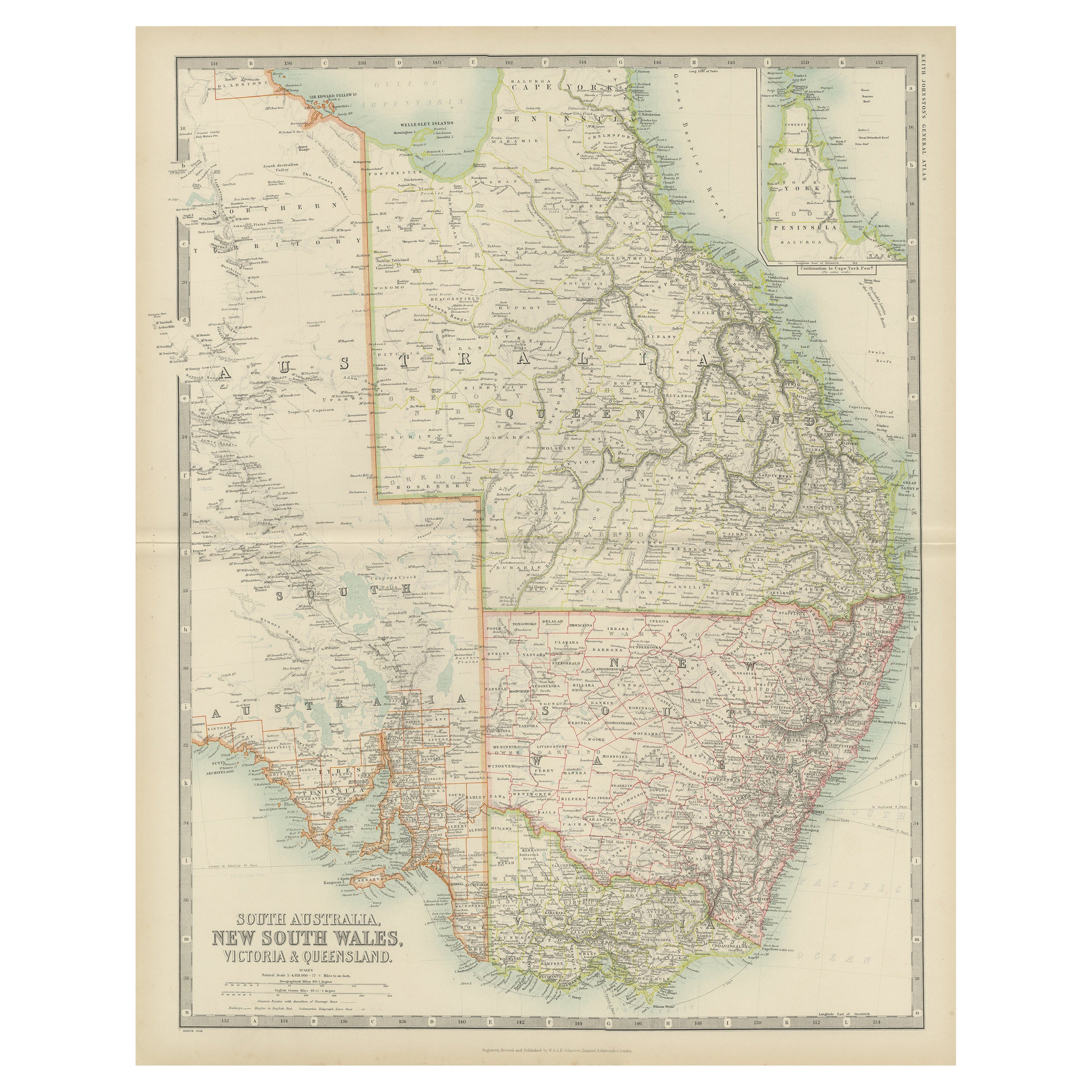
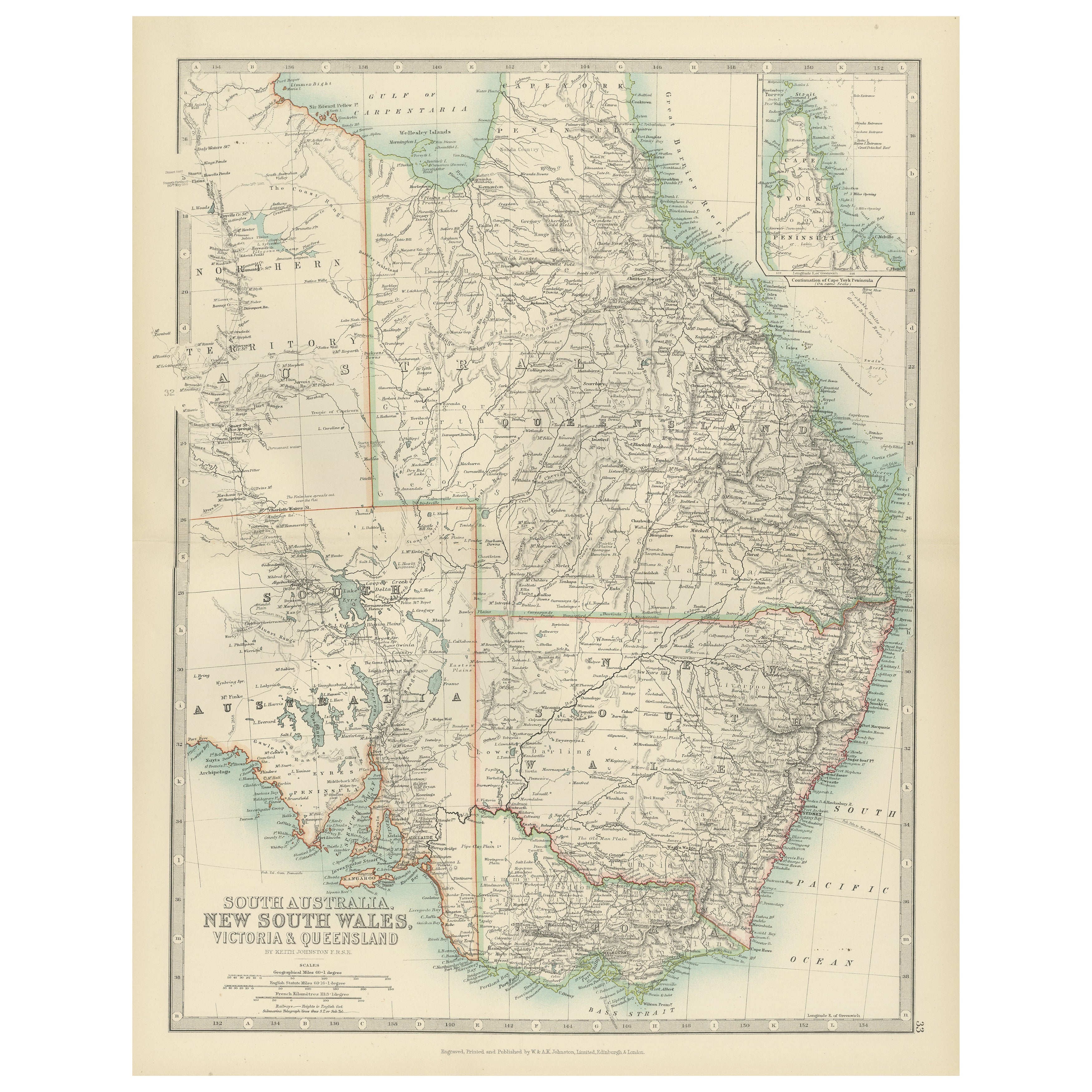
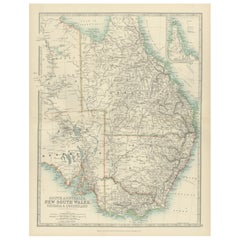
1882 Map of Queensland, New South Wales, and Victoria with Detailed Features
$298.46
£222.70
€250
CA$416.19
A$455.95
CHF 238.18
MX$5,481.44
NOK 2,977.66
SEK 2,808.40
DKK 1,903.70
About the Item
This 1882 map of Queensland, New South Wales, and Victoria, published by Blackie and Son as part of the 'Comprehensive Atlas and Geography of the World,' provides a detailed depiction of Australia's southeastern regions. It captures the geographical and political divisions of the time, showcasing the states' boundaries, major cities, towns, and transportation routes. The map highlights Queensland's expansive northern territories, the populous coastal areas of New South Wales, and the growing infrastructure in Victoria.
Topographical features are rendered with remarkable detail, including mountain ranges, rivers, and deserts. The Great Dividing Range is prominently displayed, stretching along the eastern coastline, while significant rivers such as the Darling and Murray are also included. The intricate network of settlements and transport routes reflects the rapid development of the region during the late 19th century. The map's soft pastel coloring is used to differentiate the territories, enhancing its aesthetic appeal while maintaining clarity.
Condition report: The map is in good condition, with minor signs of age-related toning and light spotting. The engraving remains sharp, and the coloring is well-preserved, with no visible tears or repairs.
Framing tips: Choose a classic wooden frame in a natural or antique finish, such as walnut or dark oak, to complement the historical character of the map. Use a double mat with an inner cream or off-white color and an outer mat in light green or beige to enhance the map's subtle tones. Opt for UV-protective, anti-reflective glass to preserve the map’s condition and ensure its longevity as a display piece.
- Dimensions:Height: 22.45 in (57 cm)Width: 15.36 in (39 cm)Depth: 0 in (0.02 mm)
- Materials and Techniques:
- Period:
- Date of Manufacture:1882
- Condition:Condition report: The map is in good condition with minimal edge wear. Slight toning and occasional spotting are present, consistent with its age. The engraving remains sharp, and the colors are well-preserved. Fold line in middle, as issued.
- Seller Location:Langweer, NL
- Reference Number:Seller: BG-13601-2-741stDibs: LU3054343552772
About the Seller
5.0
Recognized Seller
These prestigious sellers are industry leaders and represent the highest echelon for item quality and design.
Platinum Seller
Premium sellers with a 4.7+ rating and 24-hour response times
Established in 2009
1stDibs seller since 2017
2,654 sales on 1stDibs
Typical response time: <1 hour
- ShippingRetrieving quote...Shipping from: Langweer, Netherlands
- Return Policy
Authenticity Guarantee
In the unlikely event there’s an issue with an item’s authenticity, contact us within 1 year for a full refund. DetailsMoney-Back Guarantee
If your item is not as described, is damaged in transit, or does not arrive, contact us within 7 days for a full refund. Details24-Hour Cancellation
You have a 24-hour grace period in which to reconsider your purchase, with no questions asked.Vetted Professional Sellers
Our world-class sellers must adhere to strict standards for service and quality, maintaining the integrity of our listings.Price-Match Guarantee
If you find that a seller listed the same item for a lower price elsewhere, we’ll match it.Trusted Global Delivery
Our best-in-class carrier network provides specialized shipping options worldwide, including custom delivery.More From This Seller
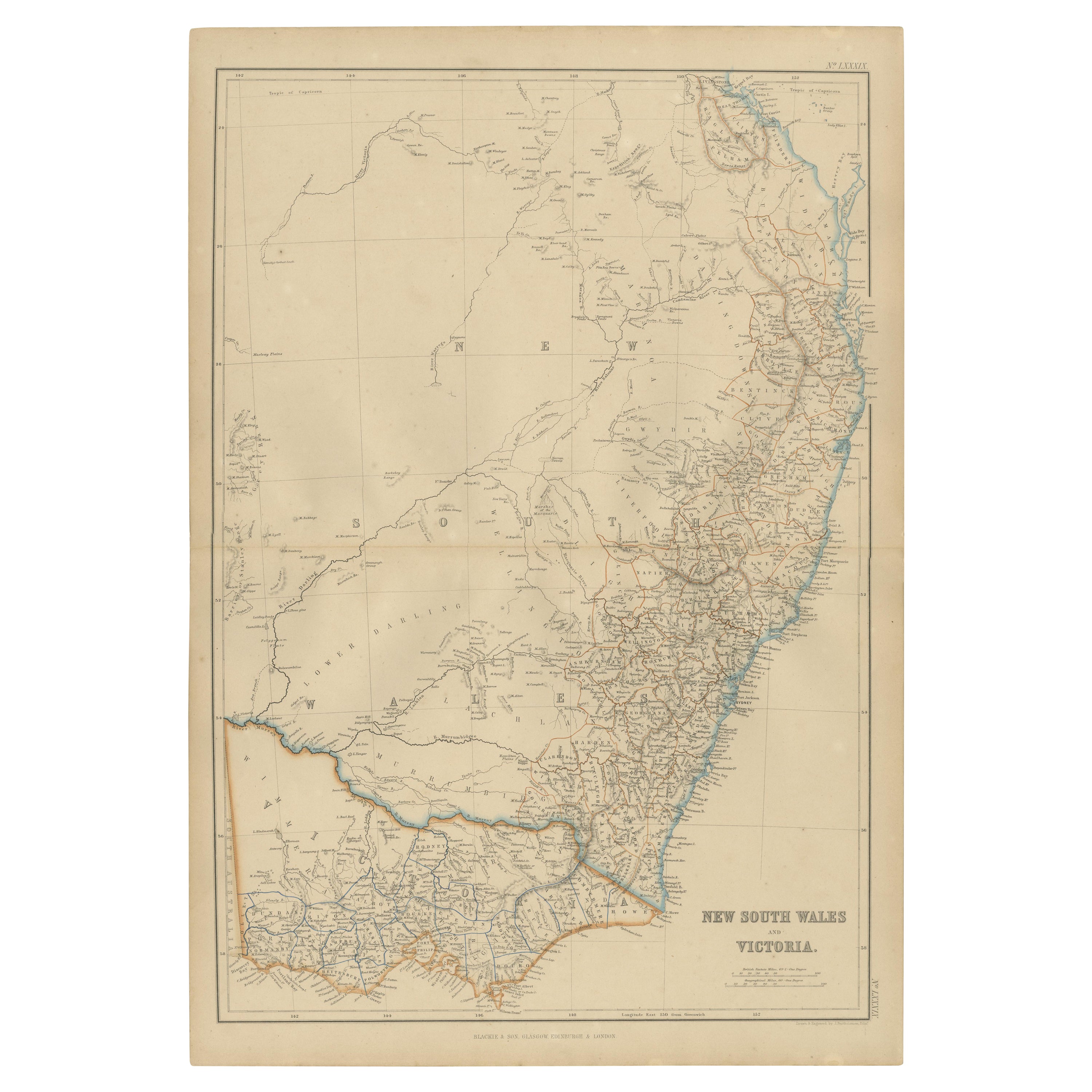
View AllAntique Detailed Map of New South Wales, Queensland & Victoria, Australia, 1865
Located in Langweer, NL
Antique map Australia titled 'South Australia, New South Wales, Victoria & Queensland'. Old map depicting South Australia including New South Wal...
Category
Antique 19th Century Maps
Materials
Paper

$334 Sale Price
20% Off
Antique Map of New South Wales by Johnston, '1909'
Located in Langweer, NL
Antique map titled 'South Australia, New South Wales, Victoria and Queensland'. Original antique map of New South Wales. With inset map of Cape York Pe...
Category
Early 20th Century Maps
Materials
Paper
$238 Sale Price
20% Off
Antique Map of New South Wales and Victoria by W. G. Blackie, 1859
Located in Langweer, NL
Antique map titled 'New South Wales and Victoria'. Original antique map of New South Wales and Victoria. This map originates from ‘The Imperial Atlas of Modern Geography’. Published ...
Category
Antique Mid-19th Century Maps
Materials
Paper
$238 Sale Price
20% Off
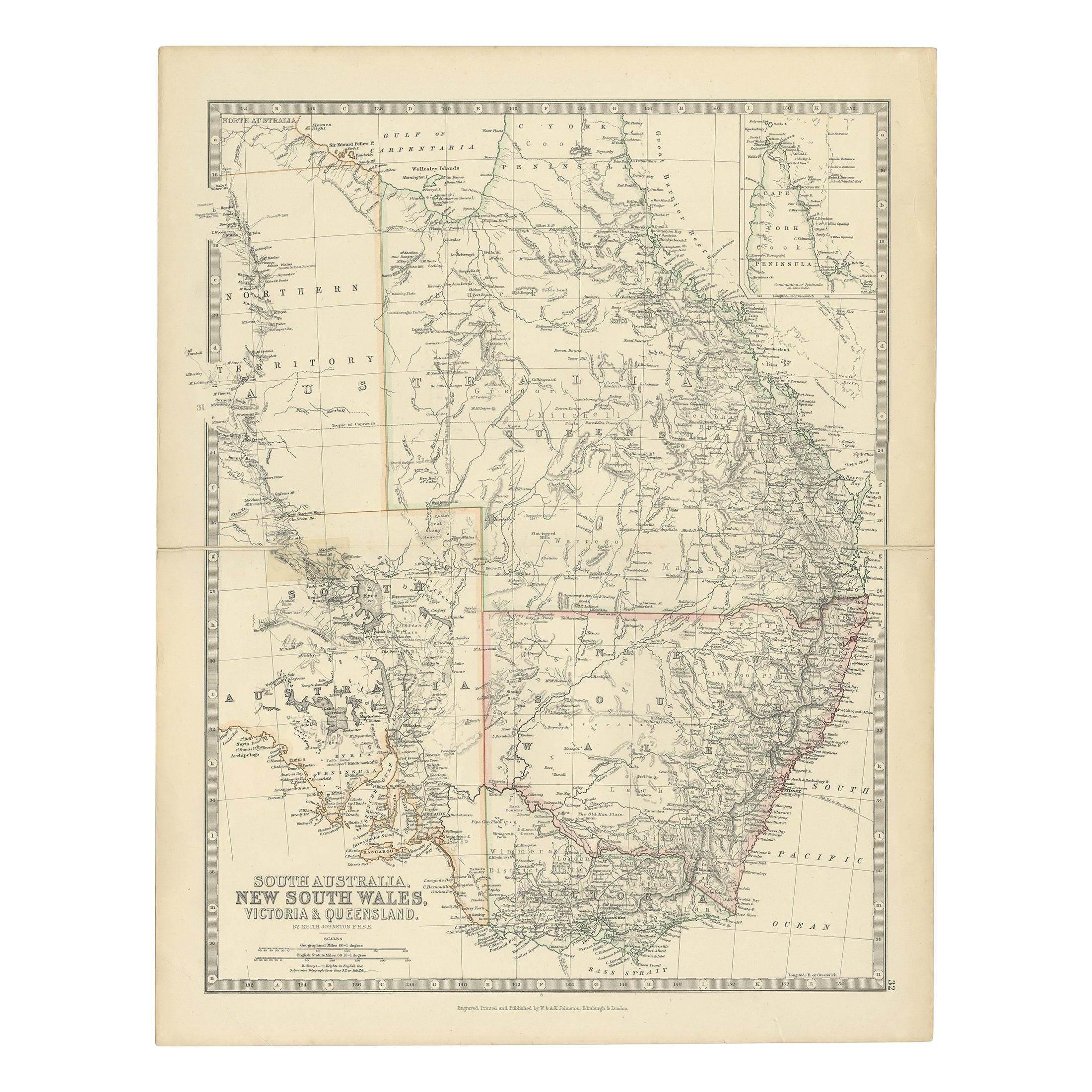
Antique Map of South Australia, Victoria, Queensland and New South Wales, c.1860
Located in Langweer, NL
Antique map Australia titled 'South Australia, New South Wales, Victoria & Queensland'. Old map depicting South Australia including New South Wal...
Category
Antique 19th Century Maps
Materials
Paper

$324 Sale Price
20% Off
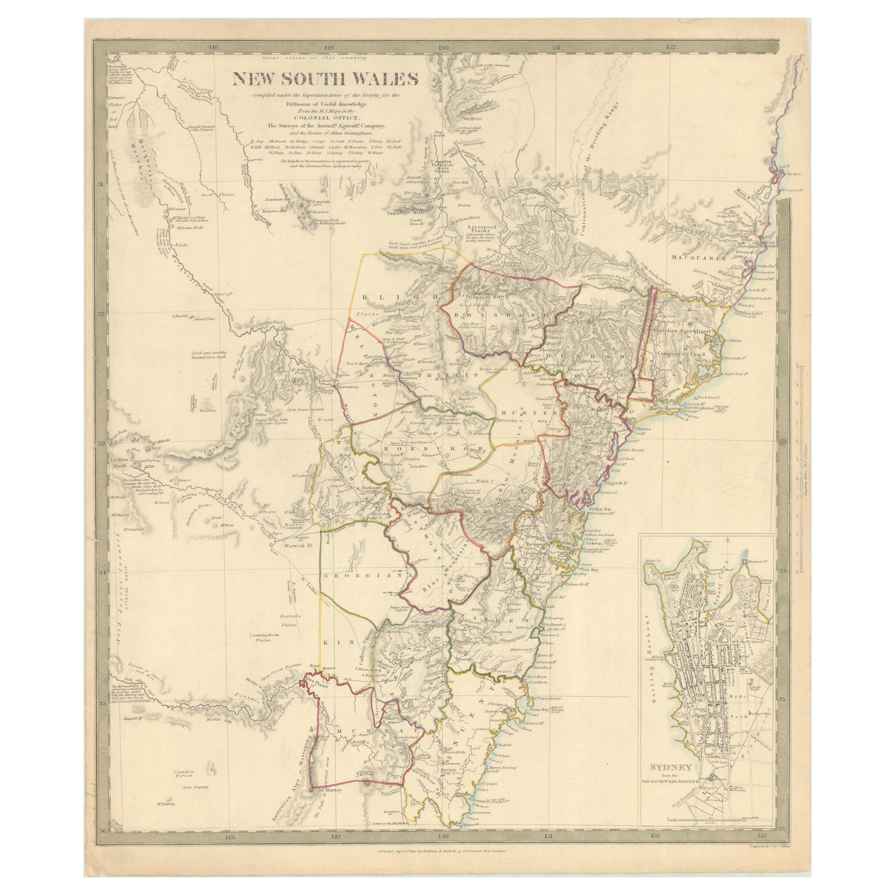
Detailed Map of New South Wales, Australia from 1833 by SDUK
Located in Langweer, NL
Detailed Map of New South Wales, Australia from 1833 by SDUK
This historical map of New South Wales, Australia, published in 1833 by the Society for the Diffusion of Useful Knowledg...
Category
Antique 1830s Maps
Materials
Paper
$534 Sale Price
20% Off
Antique Map of South Australia, New South Wales, Victoria and Queensland, 1903
Located in Langweer, NL
Title: Antique Map of South Australia, New South Wales, Victoria, and Queensland, 1903
Description:
This antique map, titled "South Australia, New South Wales, Victoria, and Queensl...
Category
Early 20th Century Maps
Materials
Paper
You May Also Like
Original Antique Map of Australia by Dower, circa 1835
Located in St Annes, Lancashire
Nice map of Australia
Drawn and engraved by J.Dower
Published by Orr & Smith. C.1835
Unframed.
Free shipping
Category
Antique 1830s English Maps
Materials
Paper

Australia, Tallis antique map, 1851
Located in Melbourne, Victoria
'Australia'
With decorative border surrounds and vignettes including a view of Sydney, Kangaroos, Natives of Australia Felix, Australian Parrots and Cockatoos and Natives of the Tri...
Category
19th Century Naturalistic Landscape Prints
Materials
Engraving

New South Wales, Australia, antique mid 19th century engraved John Tallis map
Located in Melbourne, Victoria
'New South Wales'
With decorative border surrounds and vignettes of 'Sydney Cove'. 'The Murray' and 'Xanthorrhea'.
'Drawn and engraved by J Rapkin'. Published by John Tallis.
375m...
Category
1840s Victorian Landscape Prints
Materials
Engraving

Large Original Antique Map of Australia by Sidney Hall, 1847
Located in St Annes, Lancashire
Great map of Australia
Drawn and engraved by Sidney Hall
Steel engraving
Original colour outline
Published by A & C Black. 1847
Unframed
Free shipping.
Category
Antique 1840s Scottish Maps
Materials
Paper

Vintage Australia Map, Framed, Historic 19th Century Cartography Interest, 1988
Located in Hele, Devon, GB
This is a vintage Australia map. A late 20th century reproduction of John Tallis’ original 1850 steel engraving, produced to mark the 1988 Australian Bicentennial.
Fascinating repro...
Category
1990s Australian Victorian Maps
Materials
Glass, Paper

Ancient National Atlas of France with Marengo
Located in Alessandria, Piemonte
Ancient National Atlas of France with the department of Marengo: a rare French etching dated 1806.
ST/178.
Category
Antique Early 19th Century French Other Prints
Materials
Paper

More Ways To Browse
Victoria And Son
Green Persian Rug
50 X 50 Coffee Table
Spanish Baroque Furniture
Couch Console
Vintage Burn
Sterling Silver Flatware Service For 12
Antique Dining Tables With Leaves
Decorative Wall Panels
Frank Lloyd Wright For Cassina
Natural Curved
Spanish Wool Rug
Leather Pouf And Ottomans
Low Side Tables
Set Of Four Italian Dining Chairs
Silk Runner Carpet
18th Century Blue And White Porcelain
3x5 Rugs