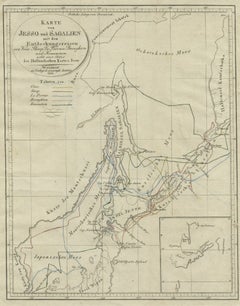
Items Similar to 19th Century Large Original Antique Map of Denmark by J. Pinkerton, 1812


Want more images or videos?
Request additional images or videos from the seller
1 of 10
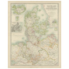
19th Century Large Original Antique Map of Denmark by J. Pinkerton, 1812
About the Item
Highly detailed map of Denmark. One of the best large format English atlas maps of the period.
Pinkerton's maps reflect the fine copperplate engraving work being done in the Britain at the beginning of the 19th century, with remarkable detail and a 3 dimensional feeling.
- Creator:Pinkerton (Artist)
- Dimensions:Height: 28.75 in (73 cm)Width: 21.26 in (54 cm)Depth: 0.02 in (0.5 mm)
- Materials and Techniques:
- Period:
- Date of Manufacture:1812
- Condition:Please study images carefully.
- Seller Location:Langweer, NL
- Reference Number:Seller: BG-004131stDibs: LU305438911283
About the Seller
5.0
Recognized Seller
These prestigious sellers are industry leaders and represent the highest echelon for item quality and design.
Gold Seller
Premium sellers maintaining a 4.3+ rating and 24-hour response times
Established in 2009
1stDibs seller since 2017
2,467 sales on 1stDibs
Typical response time: 1 hour
- ShippingRetrieving quote...Shipping from: Langweer, Netherlands
- Return Policy
Authenticity Guarantee
In the unlikely event there’s an issue with an item’s authenticity, contact us within 1 year for a full refund. DetailsMoney-Back Guarantee
If your item is not as described, is damaged in transit, or does not arrive, contact us within 7 days for a full refund. Details24-Hour Cancellation
You have a 24-hour grace period in which to reconsider your purchase, with no questions asked.Vetted Professional Sellers
Our world-class sellers must adhere to strict standards for service and quality, maintaining the integrity of our listings.Price-Match Guarantee
If you find that a seller listed the same item for a lower price elsewhere, we’ll match it.Trusted Global Delivery
Our best-in-class carrier network provides specialized shipping options worldwide, including custom delivery.More From This Seller
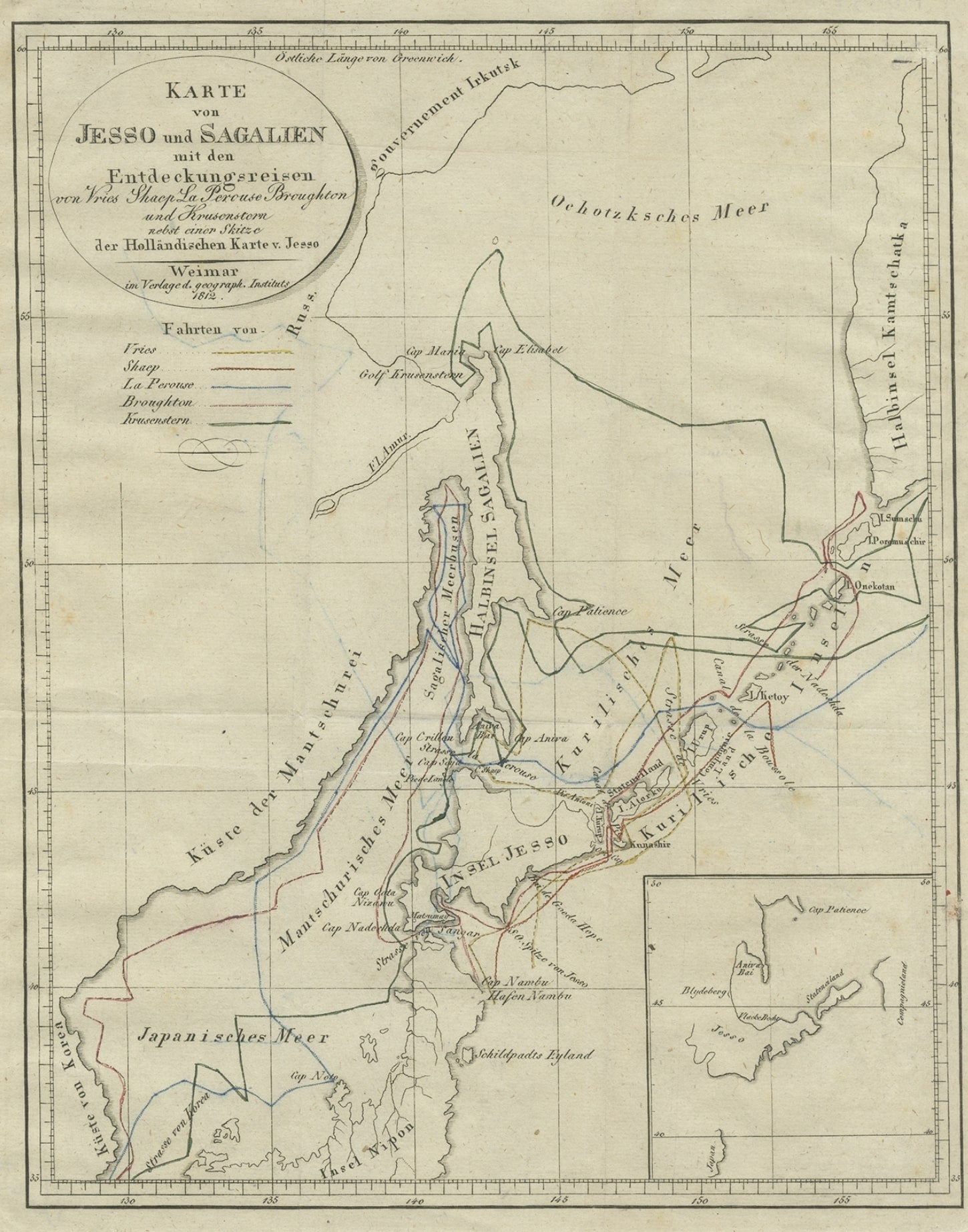
View AllAntique Map of the Region of Hokkaido, Island of Japan, 1812
Located in Langweer, NL
Antique map titled 'Karte von Jesso und Sagalien'. Old map of the region of the island of Yesso (Mororan, Hokkaido, Japan). This map originates from Volume 38 of 'Allgemeine geograph...
Category
Antique 19th Century Maps
Materials
Paper
Original Hand-colored Antique Map of Denmark by S. Neele, 1790
Located in Langweer, NL
Antique very decorative engraving of Denmark engraved by S. Neele. Published in November 1790 by John Trusler. Tape on verso.
Category
Antique Late 18th Century Maps
Materials
Paper

$195 Sale Price
20% Off
Antique Map of Denmark by Johnston '1909'
Located in Langweer, NL
Antique map titled 'Denmark'. Original antique map of Denmark. With inset maps of Iceland, Faroe Island, and Copenhagen. This map originates from the ‘Royal Atlas of Modern Geography...
Category
Early 20th Century Maps
Materials
Paper
$232 Sale Price
20% Off
Antique Map of Denmark by Lowry, 1852
Located in Langweer, NL
Antique map titled 'Denmark'. Original map of Denmark. This map originates from 'Lowry's Table Atlas constructed and engraved from the most recent Authorities' by J.W. Lowry. Publish...
Category
Antique Mid-19th Century Maps
Materials
Paper

$94 Sale Price
20% Off
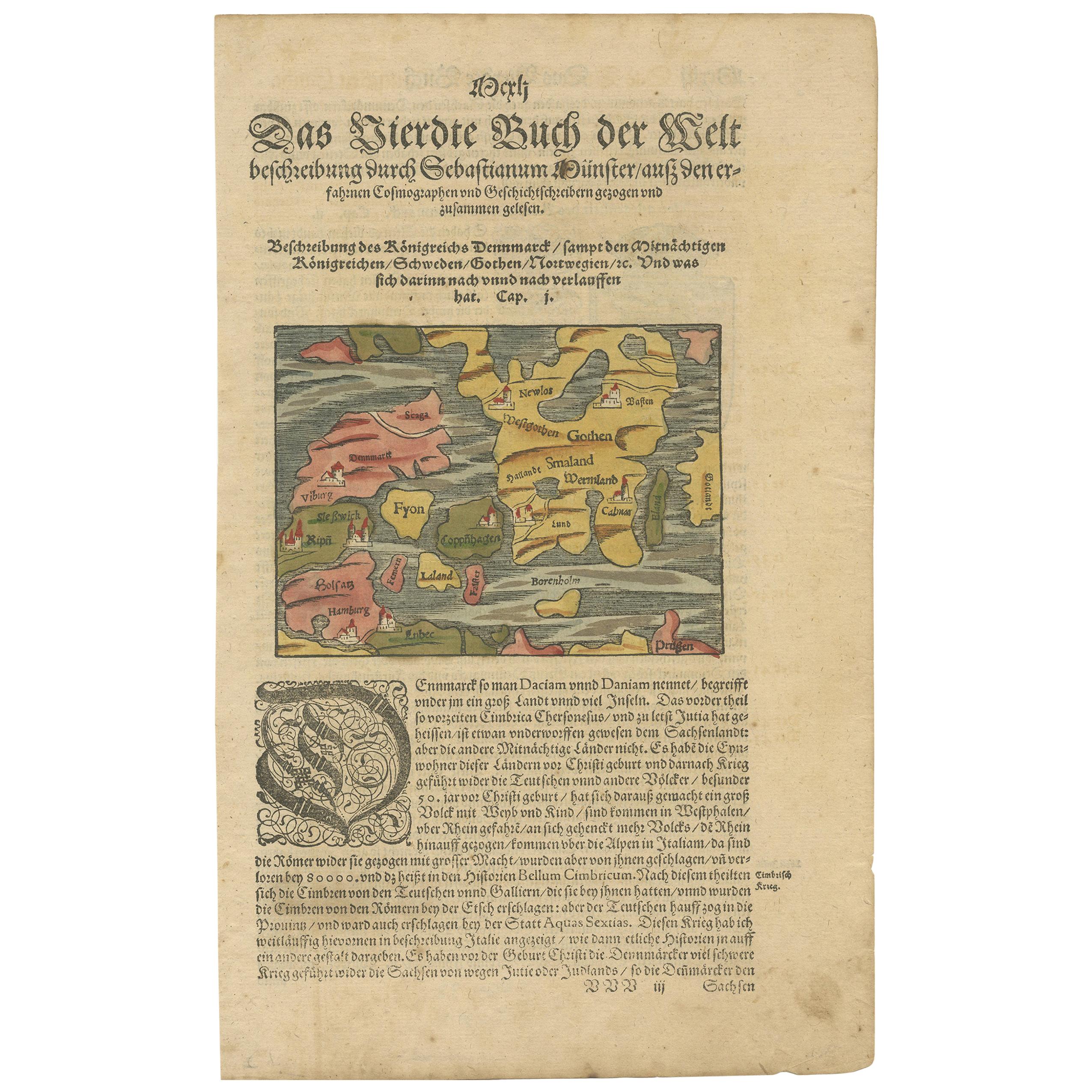
Antique Map of Denmark by Münster '1588'
Located in Langweer, NL
Antique map titled 'Beschreibung des Königreichs Dennmarck (..)'. Early map of Denmark. This map originates from 'Cosmographey Oder beschreibung Aller Länder (..)' by Sebastian Münster.
Category
Antique 16th Century Maps
Materials
Paper
$258 Sale Price
20% Off
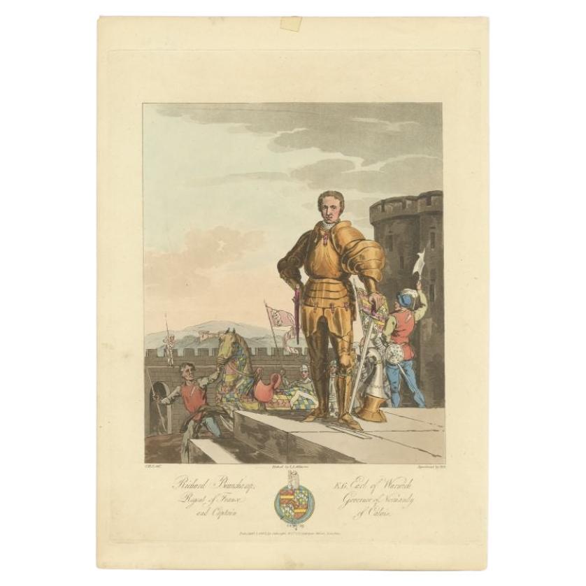
Original Antique Print of Richard Beauchamp, 5th Earl of Warwick, 1812
Located in Langweer, NL
Antique print titled 'Richard Beuchamp, H.G. Earl of Warwick'. Old print of Richard Beuchamp, 5th Earl of Warwick, standing on a platform within the walls of a castle, wearing armour, a dagger, and garter on his left leg. Originates from 'Selections of the Ancient Costume...
Category
Antique 19th Century Prints
Materials
Paper
$300 Sale Price
20% Off
You May Also Like
America "Amérique Septentrionale": A 19th Century French Map by Delamarche
By Maison Delamarche 1
Located in Alamo, CA
This framed mid 19th century map of North America entitled "Amérique Septentrionale" by Felix Delamarche was published in Paris in 1854 by Quay de l'Horloge du Palais, avec les Carte...
Category
Antique Mid-19th Century American Other Maps
Materials
Paper

Original Antique Map of Sweden, Engraved by Barlow, 1806
Located in St Annes, Lancashire
Great map of Sweden
Copper-plate engraving by Barlow
Published by Brightly & Kinnersly, Bungay, Suffolk. 1806
Unframed.
Category
Antique Early 1800s English Maps
Materials
Paper

17th Century Map of Denmark by French Cartographer Sanson, Dated 1658
By Nicolas Sanson
Located in Copenhagen, K
17th century map of Denmark by French cartographer Sanson.
Nicolas Sanson (20 December 1600-7 July 1667) was a French cartographer, termed by some the creator of French geography an...
Category
Antique 17th Century French Maps
Materials
Paper

Original Antique Map of China, Arrowsmith, 1820
Located in St Annes, Lancashire
Great map of China
Drawn under the direction of Arrowsmith
Copper-plate engraving
Published by Longman, Hurst, Rees, Orme and Brown, 1820
Unfr...
Category
Antique 1820s English Maps
Materials
Paper

Original Antique Map of South America. C.1780
Located in St Annes, Lancashire
Great map of South America
Copper-plate engraving
Published C.1780
Two small worm holes to left side of map
Unframed.
Category
Antique Early 1800s English Georgian Maps
Materials
Paper

Original Antique Map of Ireland- Kerry. C.1840
Located in St Annes, Lancashire
Great map of Kerry
Steel engraving
Drawn under the direction of A.Adlard
Published by How and Parsons, C.1840
Unframed.
Category
Antique 1840s English Maps
Materials
Paper

Recently Viewed
View AllMore Ways To Browse
Chesterfield Directors Chairs
Chinoiserie Tilt Top Table
Chippendale Wall Shelves
Chippendale Wing Chair
Christofle Knife Rests
Chrome Flat Bar Sofa
Cider Jug
Cigar Ash Tray
Cipollino Verde
Clarice Cliff Pottery
Classicon Munich
Clear Acrylic Stool
Cock Chair
Coin Silver Cup
Coin Silver Tea Set
Cole Pottery
Collana Chair
Colonial Brazil Dining Table Furniture