Items Similar to Antique German Map of India and Sri Lanka or Ceylon, 1902


Want more images or videos?
Request additional images or videos from the seller
1 of 7
Antique German Map of India and Sri Lanka or Ceylon, 1902
About the Item
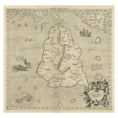
Antique map titled 'Ostindien.' (Map of India with an inset map of East-Bengal.) This attractive original old antique print / plate / map originates from 1885-1907 editions of a famous German encyclopedia: 'Meyers grosses Konversations-Lexikon.', published in Leipzig and Vienna. Meyers Konversations-Lexikon was a major German encyclopedia that existed in various editions from 1839 until 1984, when it merged with the Brockhaus encyclopedia. Several of the plates were also used in Dutch Encyclopedia's like Winkler Prins.
Artists and Engravers: The original founder and publisher who initiated this famous encyclopedia was Joseph Meyer (1796-1856, Hildburghausen, Germany).
Condition: Good, given age. Middle fold, as issued. General age-related toning and/or occasional minor defects from handling. Please study image carefully.
Date: 1902
Overall size: 24.5 x 30 cm.
Image size: 0.001 x 23 x 28 cm.
- Creator:Meyer (Artist)
- Dimensions:Height: 11.82 in (30 cm)Width: 9.65 in (24.5 cm)Depth: 0 in (0.01 mm)
- Materials and Techniques:
- Period:
- Date of Manufacture:1902
- Condition:Condition: Good, given age. Middle fold, as issued. General age-related toning and/or occasional minor defects from handling. Please study image carefully.
- Seller Location:Langweer, NL
- Reference Number:
About the Seller
5.0
Platinum Seller
These expertly vetted sellers are 1stDibs' most experienced sellers and are rated highest by our customers.
Established in 2009
1stDibs seller since 2017
1,932 sales on 1stDibs
Typical response time: <1 hour
- ShippingRetrieving quote...Ships From: Langweer, Netherlands
- Return PolicyA return for this item may be initiated within 14 days of delivery.
More From This SellerView All
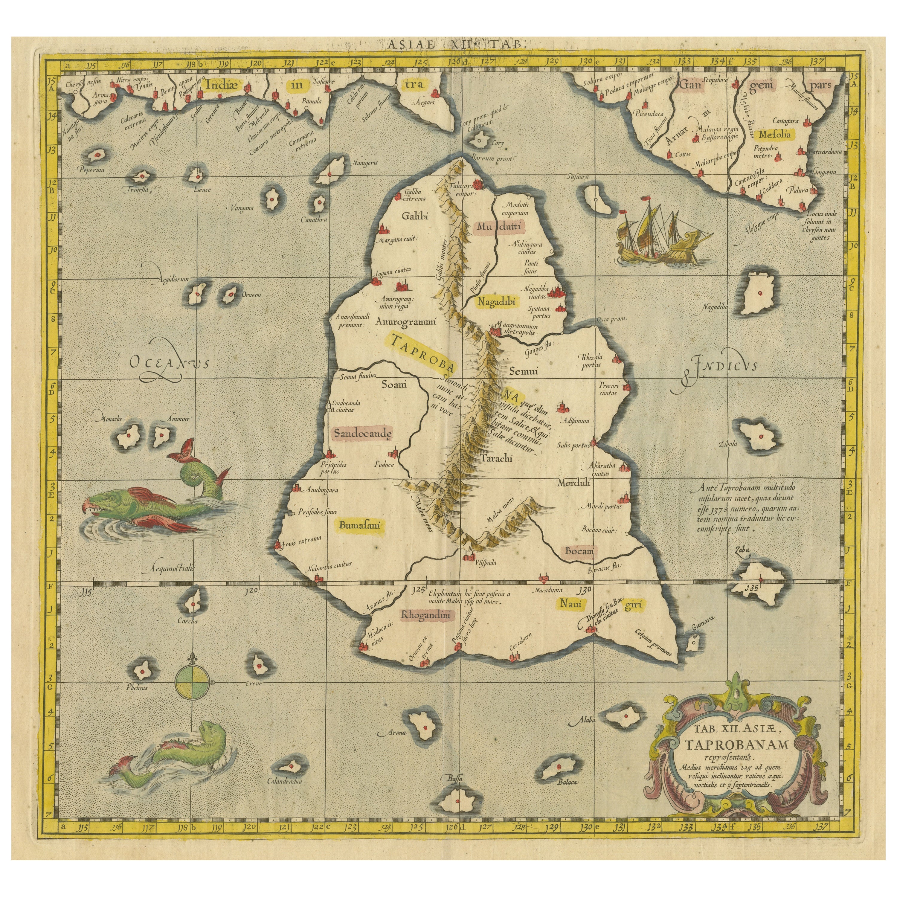
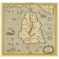
- Antique Ptolemaic Map of Ceylon or nowadays Sri LankaLocated in Langweer, NLAntique map titled 'Tab XII. Asiae Taprobanam'. Ptolemaic map of Sri Lanka. Ptolemy drew on the accounts of travelers and sailors and though the information was secondhand and often ...Category
Antique Mid-18th Century Maps
MaterialsPaper
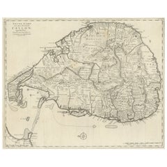
- Old Map of Southern India and Ceylon 'Sri Lanka', 1882Located in Langweer, NLAntique map titled 'India (Southern Sheet)'. Old map of Southern India and Ceylon (Sri Lanka). With an inset map of the South-Eastern Provinces of India. This map originates from...Category
Antique 1880s Maps
MaterialsPaper
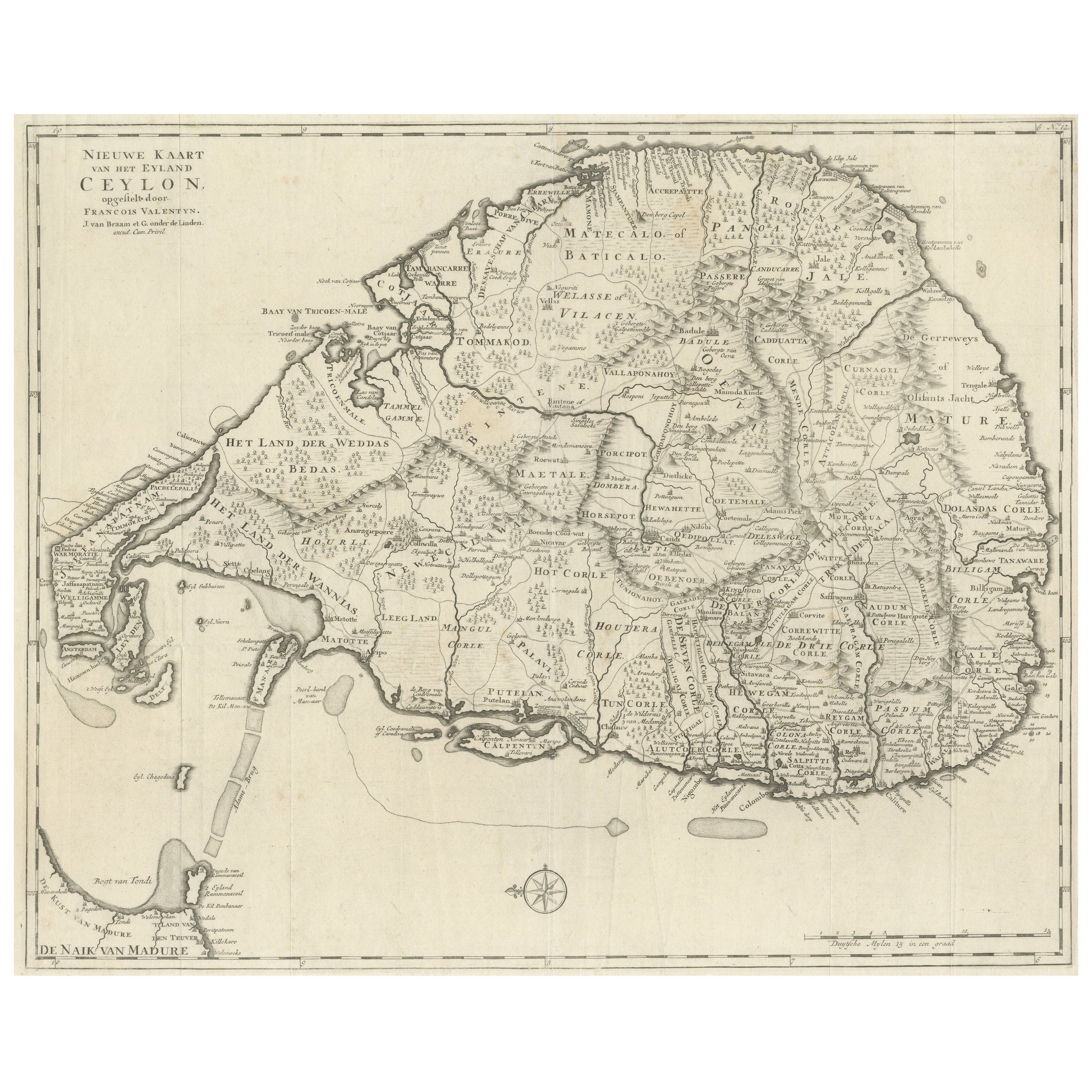
- Large Antique Map of Ceylon, Sri LankaLocated in Langweer, NLAntique map titled 'Nieuwe Kaart van het Eyland Ceylon opgestelt door Francois Valentyn'. Beautiful map of Sri Lanka. Originates from 'Oud en Nieuw Oost Indien (..)' by F. Valentijn,...Category
Antique Mid-18th Century Maps
MaterialsPaper
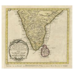
- Original Antique Map of Southern India and Ceylon 'Present-Day Sri Lanka'By Jakob van der SchleyLocated in Langweer, NLAntique map titled 'Suite de la Carte de l'Indoustan (..) - Vervolg van de Kaart van Hindoestan (..)'. Original antique map of Southern India and Ceylon (present-day Sri Lanka). This...Category
Antique Mid-18th Century Maps
MaterialsPaper
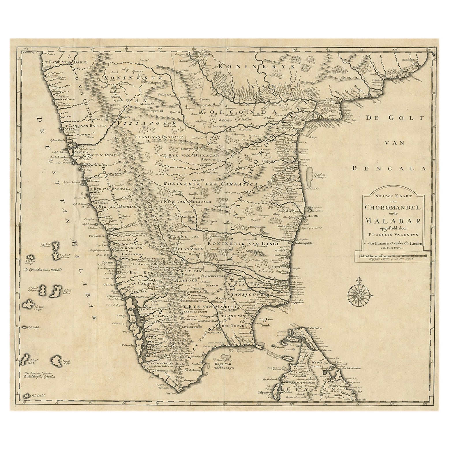
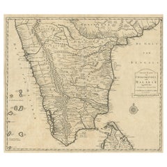
- Old Original Map of Chormandel & Malabar, India & Ceylon, Now Sri Lanka, 1726Located in Langweer, NLAntique map titled 'Nieuwe Kaart van Choromandel ende Malabar'. Antique map depicting the southern part of India and the northern tip of Ceylon, Sri Lanka. This map originates from...Category
Antique 1720s Maps
MaterialsPaper
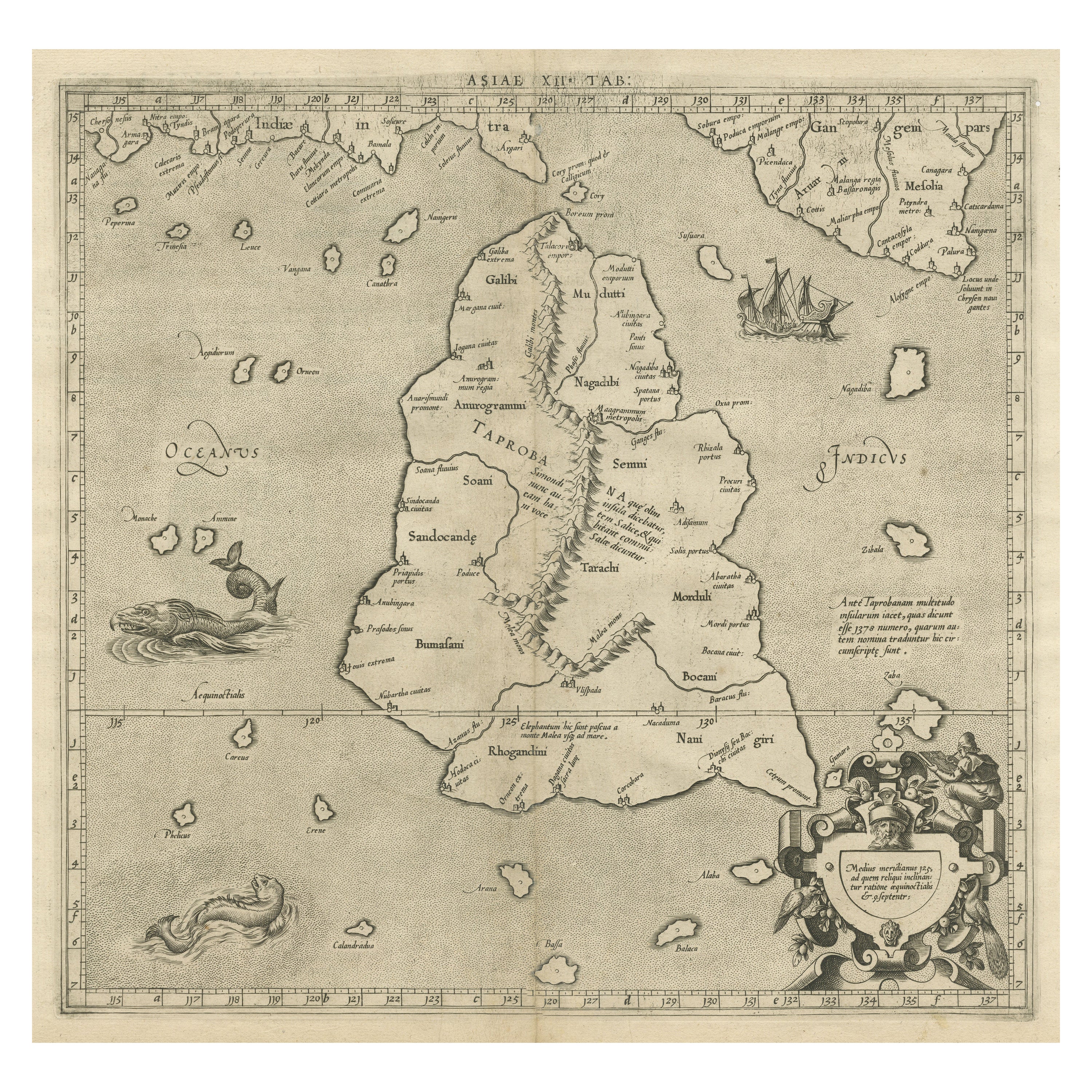
- Mercator's Ptolemaic map of Taprobana, (Ceylon) Sri LankaLocated in Langweer, NLAntique map titled 'Asiae XII Tab'. Mercator's Ptolemaic map of Taprobana. The map shows Ptolemy's erroneous location of the island of Sri Lanka near the equator, with a bit of India...Category
Antique 16th Century Maps
MaterialsPaper

You May Also Like
- Large Original Vintage Map of India, circa 1920Located in St Annes, LancashireGreat map of India Original color. Good condition / repair to some minor damage just above Sri Lanka. Shown in the last image. Published by Alexander Gross Unframed.Category
Vintage 1920s English Maps
MaterialsPaper
- Original Antique Map of Indonesia, 1861Located in St Annes, LancashireGreat map of Indonesia Drawn and engraved by Edward Weller Original color Published in The Weekly Dispatch Atlas, 1861 Repairs to minor e...Category
Antique 1860s English Victorian Maps
MaterialsPaper

- Original Antique Map of Missouri, 1889Located in St Annes, LancashireGreat map of Missouri Drawn and Engraved by W. & A.K. Johnston Published By A & C Black, Edinburgh. Original colour Unframed.Category
Antique 1880s Scottish Victorian Maps
MaterialsPaper

- Original Antique Map of New Brunswick and Nova Scotia, 1889Located in St Annes, LancashireGreat map of New Brunswick and Nova Scotia Drawn and Engraved by W. & A.K. Johnston Published By A & C Black, Edinburgh. Original colour Unfr...Category
Antique 1880s Scottish Victorian Maps
MaterialsPaper
- Large Original Antique Map of Java and Borneo, Fullarton, C.1870Located in St Annes, LancashireGreat map of Java and Borneo Wonderful figurative borders From the celebrated Royal Illustrated Atlas Lithograph. Original color. Published by Fullarton, Edinburgh. C.1870 Unfr...Category
Antique 1870s Scottish Maps
MaterialsPaper
- Original Antique Map of Cyprus. Circa 1880Located in St Annes, LancashireGreat map of Cyprus Drawn and Engraved by R.Walker Published W.Mackenzie, London Original colour Unframed.Category
Antique 1880s English Maps
MaterialsPaper


Recently Viewed
View AllMore Ways To Browse
Antiques Of India
The Vintage Map
Old India Furniture
Encyclopedia Used
Vintage Collectibles India
Old Vintage India
Antique Ceylon
Ceylon Furniture
India Map
Old Ceylon
Map Of India
Germany Vintage Map
Vintage German Map
Vintage Map Of Germany
Antique Sri Lanka
Sri Lankan Antiques
Ceylon Antique Furniture
Antique Encyclopedia